Valbona to Theth by 4x4
Most people hike this. The Valbona-to-Theth trail is one of the marquee treks in the Balkans — a day-long mountain crossing through the Albanian Alps that draws thousands of hikers each summer. They take the Koman Ferry to Valbona, walk over the pass, descend to Theth, and get a furgon out to Shkoder. It takes six to eight hours on foot.
We drove it. Not because we dislike hiking, but because we had been told it was impossible in a vehicle, and that specific phrasing has a history of being wrong.
It is not impossible. It is difficult. The track involves three river crossings of variable depth, switchbacks on exposed scree at gradients that justify low-range, and a pass at roughly 1,800 metres where the surface is loose rock with ruts from seasonal snowmelt. We managed it in a Suzuki Jimny in August 2023. It took seven hours for 65 km, which gives you an accurate picture of the driving pace. The Jimny came through intact. We came through in need of a beer.
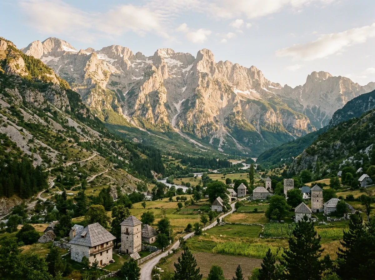
The landscape justifies every minute. The Accursed Mountains — Bjeshket e Nemuna in Albanian — are genuine Alps. Limestone towers, glacial valleys, snow patches surviving into August, waterfalls fed by snowmelt that look invented. The road, such as it is, traverses the heart of this range, and you see it from inside in a way the Tusheti Road in Georgia only hints at.
Getting there
The approach from the south: Koman Ferry
The classic approach to Valbona is via the Koman Ferry — a three-hour ride through a drowned canyon that feels like a Norwegian fjord transplanted to the Balkans. Ferries run daily from Koman (reachable from Shkoder) to Fierze, from where it is 30 km of paved road to Valbona village. The ferry takes vehicles, but book ahead — space is limited, particularly in July and August. Cost is approximately 2,000 ALL (about 18 EUR) per vehicle.
The approach from the north: Bajze and Hani i Hotit
If you are coming from Montenegro, the border crossing at Hani i Hotit puts you on the road to Bajze and then Valbona via the SH5. This road is paved for most of its length and reaches Valbona in approximately two hours from the border. Fuel up at the station in Bajze — it is the last reliable fuel before the crossing to Theth and back.
Starting point
Valbona village sits at approximately 200 metres elevation in a wide river valley. GPS: 42.4500 degrees N, 20.0333 degrees E. The track to Theth begins at the east end of the village, following the Valbona River upstream. There is a junction marked with hiking trail signs. The vehicle track is the wider path — obvious enough.
The crossing: Valbona to the pass
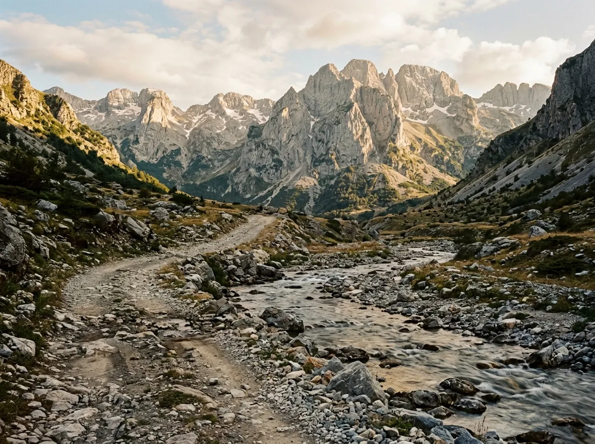
River crossings (km 0-15)
The first 15 km from Valbona follow the river valley, climbing gently through meadows and light forest. The track surface here is compact earth and gravel — reasonable driving in any 4x4 and possible (though uncomfortable) in a high-clearance 2WD.
The complication is the river crossings. There are three fords in this section, and their character changes dramatically with recent rainfall.
| Crossing | Location (approx.) | Normal depth | Post-rain depth | Bottom |
|---|---|---|---|---|
| Ford 1 | Km 5 | 25 cm | 40-50 cm | Gravel, firm |
| Ford 2 | Km 9 | 30 cm | 50-70 cm | Cobble, uneven |
| Ford 3 | Km 13 | 35 cm | 60-80+ cm | Rock and gravel, variable |
In dry August conditions, all three are manageable in a Jimny or similar without drama — water below the sills, firm footing, moderate current. After a day of rain, the river rises fast. Ford 3 becomes the critical decision point. If the water reaches the lower edge of the doors on a Jimny (approximately 50 cm), we would turn around. The current in a swollen mountain river is the danger, not the depth alone. A vehicle that can stand in 60 cm of still water can be pushed sideways in 40 cm of fast water.
Walk each ford before driving it. Every time. Check the depth with a stick. Check the bottom for holes. Look at the exit bank — is it gravel or mud? We spent 10 minutes assessing each ford, which felt excessive until we watched a Land Cruiser from a local tour company bury itself to the axles in Ford 2 by charging through without looking.
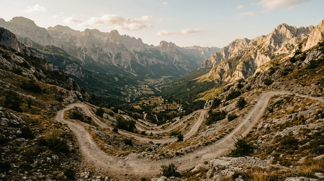
The switchback ascent (km 15-25)
After the third ford, the character of the track changes completely. The valley narrows, the gradient steepens, and the surface transitions from compact gravel to exposed rock and scree. Over the next 10 km, the track gains approximately 1,400 metres of elevation through a series of switchbacks carved into the mountainside.
This is where low-range earns its keep. The gradient on some of the switchback ramps exceeds 20 percent. The surface is loose — scree, rubble, occasional bedrock — and the traction is inconsistent. In the Jimny, we ran low-range second gear for most of the ascent. The engine worked hard. The transmission worked harder. The cooling system earned our respect.
The switchbacks are tight — the Jimny’s turning circle was barely adequate on some of the hairpins, and a full-size Land Cruiser would need three-point turns. The track is single-lane with occasional passing places, most of which coincide with corners where you are already committed.
Two things to note: the exposure is significant (several hundred metres of unguarded drop on the valley side of many switchbacks), and the track is shared with hikers. We encountered approximately 30 hikers on the ascent, most of whom were gracious about pressing against the rock face while we inched past. Go slowly. Use your horn on blind corners. Yield to hikers whenever physics allows.
The pass (km 25-28)
Qafa e Valbones — the Valbona Pass — sits at approximately 1,800 metres in a saddle between two limestone peaks. The track flattens here, the views open in every direction, and you can stop, breathe, and contemplate what you just drove and what you are about to descend.
The pass area is windswept and bare. On the day we crossed, there was patchy snow on the north-facing slopes despite it being mid-August. A shepherd was grazing cattle. A dozen hikers were sitting on rocks eating lunch. The Jimny looked deeply out of place among the hiking poles and trail runners.
There is no water at the pass. No shelter. No coverage. You are at the midpoint of a route that has no exit except forward or backward, and both directions involve significant effort. This is the commitment point — once you begin the descent to Theth, turning around means climbing back over the pass.
The descent: Pass to Theth
The upper descent (km 28-38)
The Theth side of the pass is, somewhat surprisingly, in better condition than the Valbona side. The switchbacks are still steep and the surface is still loose rock, but the track is wider, the hairpins are more generous, and the gradient is slightly less severe. This may be because the Theth side receives more vehicle traffic — local furgon drivers from Shkoder have been running this road for years.
Low-range is still essential for engine braking on the descent. We ran low-range first gear for the steepest sections, letting the engine control the speed. The temptation to ride the brakes is strong but foolish — 10 km of continuous braking on a 15-20 percent gradient will overheat any brake system. We stopped twice on the descent to let the brakes cool, which is boring advice but the alternative is arriving at a hairpin with faded brakes and a valley below.
The valley approach (km 38-50)
Below 800 metres, the track enters the Theth valley and the gradient eases. Dense forest — beech and pine — closes in on both sides, and the surface transitions to compacted earth and gravel. The river reappears, running clear and fast through the valley floor. There are no fords on the Theth side; the track stays on the west bank.
The driving here is straightforward — moderate speeds on a reasonable surface with occasional rock outcrops that require attention but not anxiety. This section is the reward: deep valley, high walls, sound of water, green in every direction.
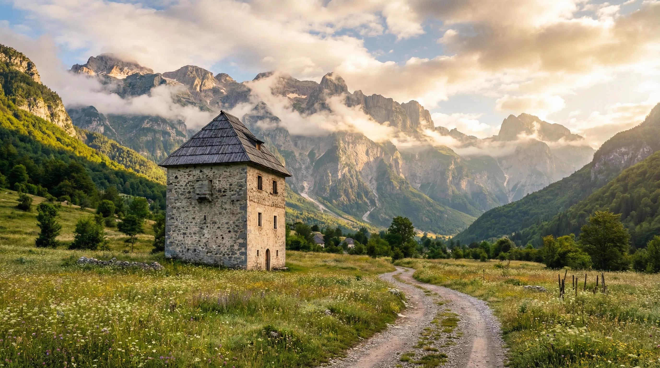
Theth village (km 50-55)
Theth appears gradually — first a church, then stone houses, then guesthouses. The village sits at approximately 750 metres in a broad valley floor below the Lock-in Tower, a medieval stone structure historically used for blood feud isolation (a man under threat of retribution could lock himself inside until the feud was negotiated). It is Albania’s most famous example of the Kanun — the customary law code that governed these mountains for centuries.
The village has guesthouses (book ahead in summer), a few restaurants, and a shop with basic supplies. There is no fuel station. There is no mobile coverage. There is a sense of having arrived somewhere genuinely remote, which in 2023 Europe is increasingly rare.
The Theth to Shkoder road (km 55-65)
From Theth, a recently improved road descends to Shkoder — approximately 65 km of mountain road that has been partially paved and partially gravel-graded as of our visit. This road is the escape route: passable in a high-clearance 2WD under current conditions, though it is winding and slow. Allow two hours for the drive to Shkoder. Fuel is available in Shkoder.
Practical information
| Item | Detail |
|---|---|
| Total distance | 65 km (Valbona village to Theth village) |
| Driving time | 5-7 hours depending on conditions and stops |
| Fuel | Fill up in Bajze (from north) or Fierze (from south). No fuel on route. Round-trip range from last fuel: ~130 km |
| Water | 3L per person minimum. River water is drinkable above the villages if filtered |
| Season | Mid-June to mid-October. Snow-free window varies by year. Confirm locally. |
| Mobile coverage | None on the entire crossing. Coverage returns near Shkoder. |
| Accommodation | Guesthouses in Valbona (before) and Theth (after). 20-40 EUR per person with dinner. |
| Emergency | No roadside assistance exists on this route. Self-recovery only. Nearest hospital: Shkoder (2+ hours from Theth). |
One-way or round trip
Most people drive this one-way, staging a vehicle at one end or arranging pickup. If doing one-way, the Valbona-to-Theth direction is harder than Theth-to-Valbona because the river crossings and the rougher switchbacks are on the Valbona side, and climbing them in reverse from Theth means tackling the harder terrain while already fatigued from the pass descent.
Our recommendation: start from Valbona while you are fresh and the day is long. Overnight in Theth. Drive out to Shkoder the next morning.
If returning to Valbona — because your accommodation or your ferry ticket is there — leave Theth early. The afternoon heat makes the pass climb harder on the engine, and you want daylight margin for the river crossings.
Who should drive this
We will be direct. This route is not for first-time off-roaders. The combination of river crossings, steep gradients on loose surfaces, exposure, and total isolation from assistance means that mistakes have consequences beyond inconvenience. If you have driven mountain tracks before — Tusheti in Georgia, Sani Pass in South Africa, or similar — you have the skills and the calibration. If your off-road experience is limited to graded gravel roads, start with the Riviera Coastal Tracks or Llogara Pass to build confidence.
That said: if you have the experience, this is one of the great drives in Europe. The Albanian Alps are world-class scenery, the track is a genuine adventure, and the sense of accomplishment at the end is earned in a way that paved mountain passes — however pretty — cannot replicate.
Return to the Albania hub for the full country overview.