Ethiopia
Route Specimens
3 routes surveyed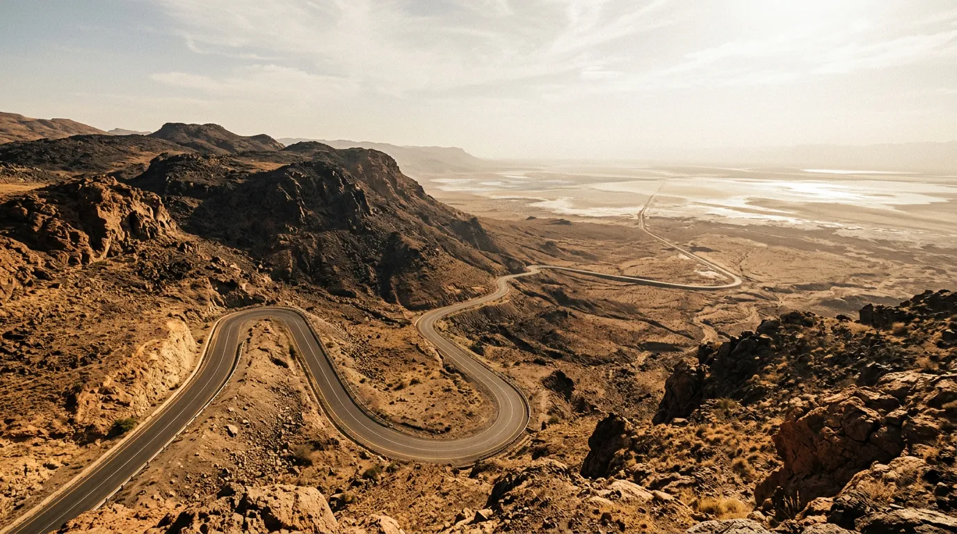
Ethiopia Off-Road Routes
Ethiopia broke something in our understanding of what a road can be. We had driven mountain passes in Georgia, sand deserts in Jordan, and gravel plains across Namibia, and we thought we had a reasonable grasp of the range of terrain a vehicle can traverse. Then we drove the Simien Mountains, where the road is a shelf carved into a cliff face at 4,000 metres with a vertical drop on one side and a vertical wall on the other, and gelada baboons sitting on the edge watching you pass with the mild disinterest of spectators at a performance they have seen before. Then we descended toward the Danakil Depression, where the road drops from highland plateau to 125 metres below sea level through terrain that looks like the set design for a planet that did not work out. Then we crossed the Omo Valley, where the road exists as a concept rather than a physical object — a general direction through bush and riverbed that your vehicle follows with varying degrees of success.
Ethiopia is the most challenging country we have driven. It is also, by a margin that surprises us every time we review the photos, the most visually extraordinary. The country sits at the junction of the East African Rift Valley and the Ethiopian Highlands — a geological arrangement that creates an elevation range of nearly 5,000 metres within a few hundred kilometres, and terrain diversity that no other country we have visited can match. You can start a day in cloud forest at 3,500 metres, cross a pass at 4,500 metres where the air is thin enough to make you lightheaded, and end in volcanic desert at sea level where the ground temperature exceeds 70 degrees Celsius. This is not a metaphor for variety. This is a single day’s driving plan.
We have driven three routes: the Simien Mountains Circuit through Africa’s highest road passes, the Danakil Approach Road descending into the hottest inhabited place on Earth, and the Omo Valley Tracks through the remote south where Ethiopia meets Kenya and South Sudan. Between them, they cover 710 km, an elevation span of 4,625 metres, and the full spectrum from Africa’s most dramatic mountain driving to its most extreme desert expedition.
Terrain classification
Ethiopia’s geology is the product of the East African Rift — a tectonic boundary that is slowly splitting the Horn of Africa from the rest of the continent. The rift created the highland plateau (averaging 2,500 metres), the escarpments that drop from it, and the depression basins (including the Danakil, one of the lowest and hottest places on Earth). The terrain types are extreme, not just varied.
| Terrain type | Where you find it | Vehicle requirement |
|---|---|---|
| Highland plateau | Simien, central highlands | 4x4 with low-range for passes |
| Escarpment road | Simien cliff edges, Rift Valley drops | 4x4 essential, nerve essential |
| Volcanic desert | Danakil approach, Afar region | Expedition 4x4, convoy mandatory |
| River valley | Omo Valley, Blue Nile gorge | 4x4 with high clearance |
| Rocky highland | Above 3,500m, Simien plateau | 4x4, slow pace for altitude |
| Laterite track | Omo Valley, southern lowlands | 4x4, impassable when wet |
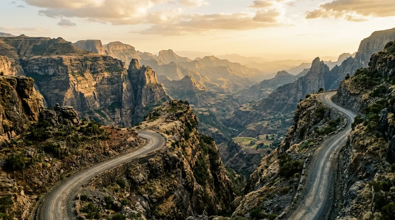
The defining characteristic of Ethiopian terrain is verticality. Roads in the highlands do not contour gradually around obstacles — they climb directly up escarpments and drop straight down the other side. Hairpin switchbacks with no guardrails and 500-metre drops are not exceptional features but standard road design. The Ethiopian approach to mountain road engineering appears to be: cut a shelf, hope for the best, maintain with occasional gravel.
Our documented routes
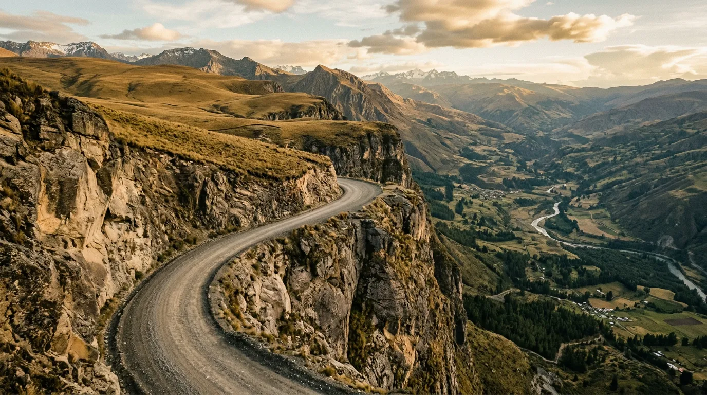
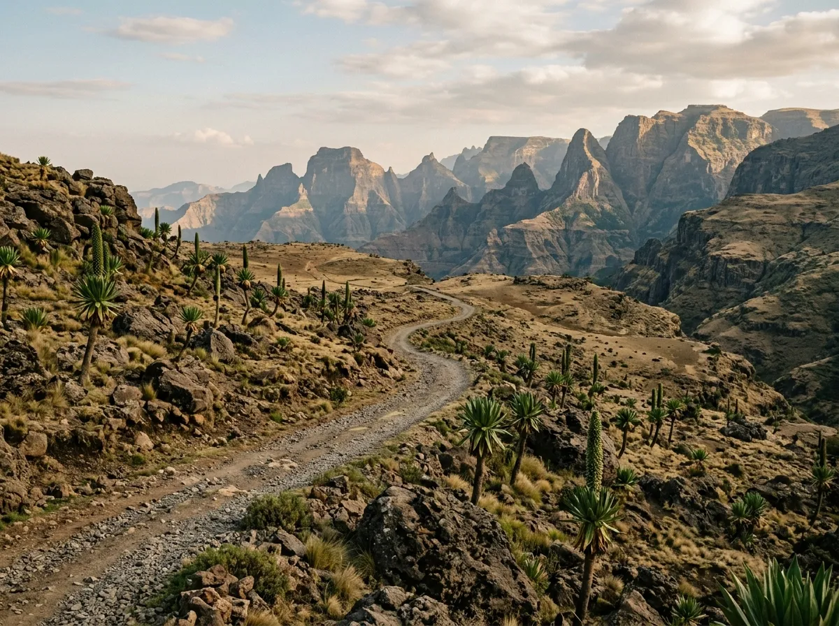
Simien Mountains Circuit
| **Catalog: TB-ET-001 | Difficulty: Challenging | Distance: 180 km | Duration: 3-4 days** |
The showcase. A multi-day circuit through the Simien Mountains National Park — a UNESCO World Heritage Site and the location of several of Africa’s highest peaks. The road climbs from the gateway town of Debark at 2,800 metres to a maximum elevation above 4,400 metres, traversing cliff-edge tracks, highland grassland, and afro-alpine moorland where giant lobelia and tree heather create a landscape that looks like a botanical hallucination. The gelada baboons — endemic primates that live in herds of up to 400 — sit on the cliff edges as you drive past, grooming each other and occasionally regarding your vehicle with the weary tolerance of animals that have seen many Land Cruisers. A mandatory armed scout accompanies you in the park. The driving is challenging primarily because of the exposure — the cliff drops are real, the road is narrow, and altitude above 3,500 metres affects judgment and reaction time. Read the full route guide.
Danakil Approach Road
| **Catalog: TB-ET-002 | Difficulty: Expert | Distance: 230 km | Duration: 2-3 days** |
The extreme route. The road from Mekelle descends from the Ethiopian Highlands at 2,200 metres to the Danakil Depression at minus 125 metres — a vertical drop of 2,325 metres through terrain that transitions from highland agriculture to volcanic wasteland. The Danakil is one of the hottest inhabited places on Earth, with daytime air temperatures regularly exceeding 50 degrees Celsius and ground temperatures approaching 70 degrees. Travel requires a mandatory armed escort (arranged through licensed operators in Mekelle), a convoy of at least two vehicles, and expedition-level preparation. This is not a route for beginners. It is arguably not a route for anyone with a fully functioning sense of self-preservation. It is also one of the most singular driving experiences on the planet — the volcanic landscape of sulphur springs, salt flats, and lava lakes has no equivalent anywhere we have driven. Read the full route guide.
Omo Valley Tracks
| **Catalog: TB-ET-003 | Difficulty: Challenging | Distance: 300 km | Duration: 3-5 days** |
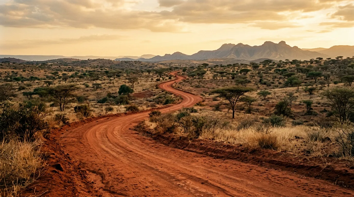
The remote route. The lower Omo Valley in Ethiopia’s southwest is one of the most culturally diverse regions in Africa — home to multiple ethnic groups whose lifestyles have changed less in the past century than anywhere else we have visited. The driving reflects this isolation: the tracks are seasonal, the river crossings are real (not the engineered ford type), and the concept of a “road” in the Omo Valley is more aspiration than description. Navigation requires local knowledge, a willingness to reverse when a track dead-ends at a river that has changed course since the last dry season, and patience measured in hours rather than minutes. The reward is access to a landscape and culture that most travelers see only from organized tour vehicles. Read the full route guide.
Practical information
Vehicle selection
Ethiopia’s rental market is limited and the vehicles available are generally older and harder-used than what you find in Kenya or Tanzania. The standard expedition vehicle is a Toyota Land Cruiser 70 Series — the workhorse of East African off-road travel, and the only vehicle we would recommend for all three routes. Land Cruiser Prados are available and adequate for the Simien circuit, but the lower clearance and shorter suspension travel make them marginal for the Omo Valley and insufficient for the Danakil approach.
Rental with driver is the norm in Ethiopia. Self-drive rental exists but the agencies will question your route plans — not unreasonably, given the terrain. Expect to show evidence of off-road experience before being handed keys for a vehicle destined for the Simien Mountains. For the Danakil, self-drive is theoretically possible but practically inadvisable without local knowledge.
Rental cost: $120-200 per day for a Land Cruiser, typically including a driver. Without driver: $80-150 per day (limited availability).
Fuel planning
Ethiopia’s fuel supply is unreliable even in the cities. Fuel shortages are periodic, caused by supply chain disruptions, currency issues, and distribution logistics that do not always function as designed. When fuel is available, fill up. This applies in Addis Ababa, in regional capitals, and especially in the gateway towns for our routes.
| Route | Last reliable fuel | Next fuel | Gap |
|---|---|---|---|
| Simien Mountains | Debark | Debark (return) | ~200 km round trip |
| Danakil Approach | Mekelle | Mekelle (return) or Afar settlements (unreliable) | ~500 km round trip |
| Omo Valley | Jinka or Turmi | Variable, often dry | ~350 km |
Carry jerry cans. For the Danakil, 60+ litres of reserve fuel is not excessive. For the Simien circuit, 20 litres is sufficient. For the Omo Valley, 40 litres is the minimum.
Season and weather
Ethiopia has two seasons that matter: dry (October to March, locally called Bega) and wet (June to September, locally called Kiremt). The driving season is the dry season, without exception. The wet season turns highland roads to mud, swells the Omo River to uncrossable levels, and makes the Danakil approach road a torrent channel.
The Simien Mountains are best from October to December — clear skies, cool temperatures, and dry roads. The Danakil is best from November to February — the “coolest” period, when daytime temperatures are merely 40-45 degrees instead of 50+. The Omo Valley is best from October to March.
Permits, escorts, and bureaucracy
Ethiopia requires more logistical preparation than any other country we document. The permit requirements vary by route:
| Route | Permit/escort requirement | Arranged where |
|---|---|---|
| Simien Mountains | Park entry fee ($20/day) + mandatory armed scout ($15/day) | Debark park office |
| Danakil | Mandatory licensed guide + armed Afar escort + convoy | Mekelle tour operators |
| Omo Valley | Regional permits (vary by specific area) | Jinka, Turmi, or Addis |
The Simien scout is non-negotiable — you will not be allowed to enter the park without one. The scout is armed (rifle), which feels dramatic until you realize the park contains wildlife that warrants the precaution, and that the scout’s primary function is navigation rather than protection.
The Danakil escort arrangement is more complex: a licensed operator in Mekelle provides a guide, armed Afar escorts (the Afar region has its own security dynamics), a lead vehicle, and logistical support. Independent travel in the Danakil is neither permitted nor sensible. Budget $200-400 per person for a 2-3 day organized trip.
Field notes
Ethiopian roads are shared infrastructure. They are used simultaneously by pedestrians, donkey carts, livestock herds, buses, trucks, and the occasional vehicle driving in a direction that bears no relationship to which side of the road is designated for traffic. Driving in Ethiopia requires constant vigilance, frequent horn use (the horn is a communication tool, not an expression of frustration), and a speed that allows for the sudden appearance of a cow, a child, or an oncoming truck in your lane.
The hospitality is genuine and occasionally intense. In rural areas, stopping the vehicle will attract a crowd within minutes — curious, friendly, and sometimes overwhelming. Children will ask for money, pens, or empty water bottles (the bottles have practical value). Adults will offer directions, coffee, or conversation. The coffee, when offered, should be accepted — Ethiopian coffee is exceptional, the ceremony is important, and the thirty minutes it requires is time well spent.
Ethiopian food is excellent and uniform: injera (a spongy flatbread) with various wats (stews). You will eat injera for every meal. This is not a limitation — the wats are diverse and delicious. Vegetarian options are abundant due to the Orthodox Christian fasting tradition, which restricts animal products for approximately 200 days per year.
Altitude is a real factor. The Simien circuit spends extended time above 3,500 metres, and the pass above 4,400 metres will affect anyone who has not acclimatized. Symptoms of mild altitude sickness (headache, nausea, fatigue) are common. Spend at least one night in Debark (2,800 metres) before ascending. Carry Diamox if your doctor advises it. Descend if symptoms worsen.
Mobile coverage exists in towns and is absent in the parks and remote areas. Safaricom-style mobile money does not exist in Ethiopia — carry cash (Ethiopian Birr) in small denominations for fuel, food, and permits. ATMs exist in regional capitals but do not always function.
Related regions
Ethiopia’s driving has no precise equivalent. The closest comparison for the mountain routes is Tanzania — specifically the escarpment roads approaching the Rift Valley — but Tanzania’s terrain is less extreme and the infrastructure more developed. For volcanic terrain, Iceland offers a geological parallel — highland tracks across lava fields — though the climate could not be more different. Jordan shares the desert canyon driving experience, though at a fraction of the scale and intensity of the Danakil.
If Ethiopia appeals to you, you are probably beyond the point where we need to recommend alternatives. You are looking for the most challenging, most remote, most visually extreme driving Africa offers. This is it.
Ground clearance, tire type, and 4x4 lock differ between agencies. Compare before you book.