Morocco
Route Specimens
3 routes surveyed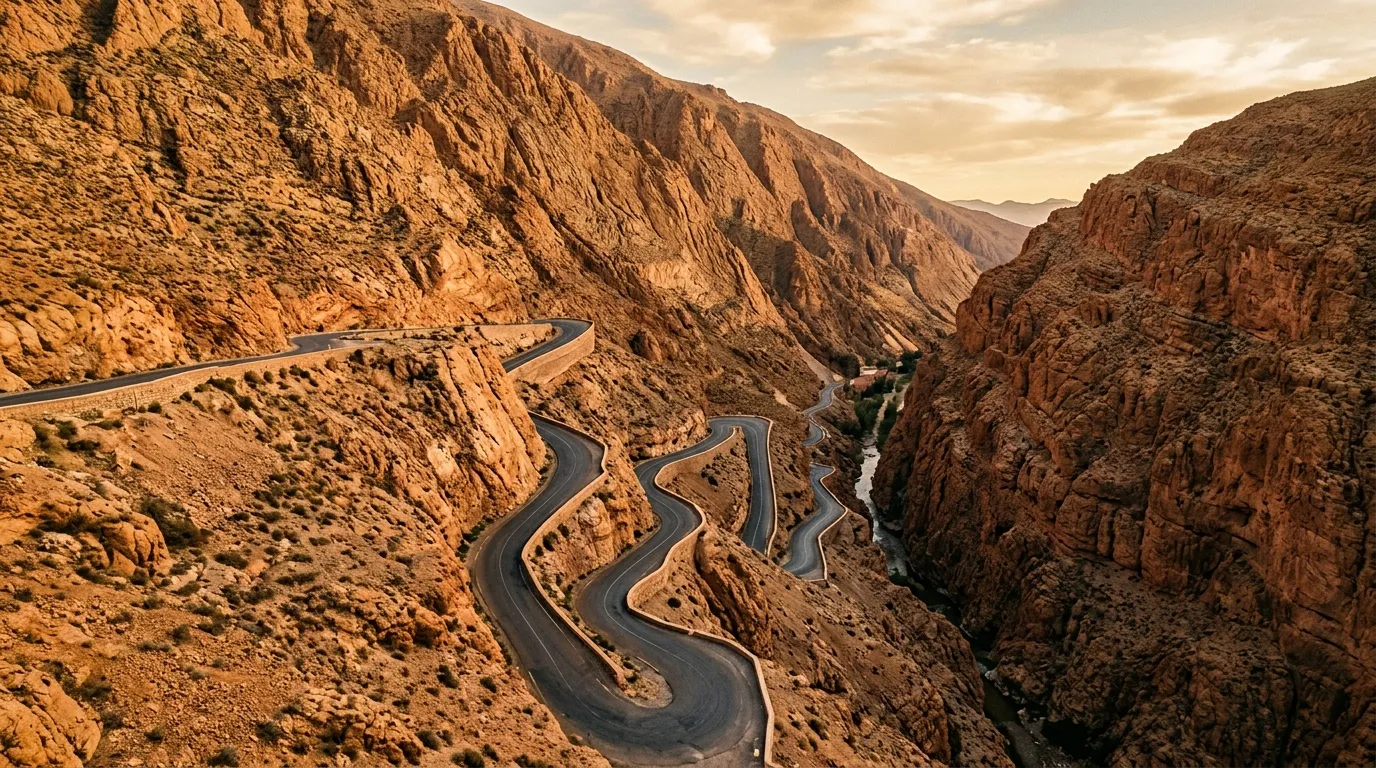
Morocco Off-Road Routes
Morocco is the country that taught two generations of European overlanders what a dirt road looks like. Before the Balkans opened up, before Oman built its tourism infrastructure, before Georgia started appearing on adventure driving blogs, there was Morocco — and specifically, there was the network of pistes, mountain passes, and desert tracks that connects the Atlas Mountains to the Sahara and makes the 300 km between Marrakech and the dunes feel like a journey across geological time.
We have driven three routes that represent the range of what Morocco offers. The Tizi n’Test pass crosses the High Atlas at 2,100 metres on a road that is technically paved but practically a mountain adventure. The Merzouga to Zagora Sahara piste is a 350 km desert crossing that qualifies as expert-level driving — sand, stone desert, and navigation by piste markers across terrain where the nearest help is measured in days, not hours. And the Dades and Todra Gorges offer the most accessible version of Morocco’s canyon driving, with paved gorge roads and dirt side-canyon detours that work in a 2WD.
Together, these routes cover mountain, desert, and canyon terrain across a 400 km stretch of southern Morocco. They can be driven independently or linked into a multi-week circuit.
Terrain classification
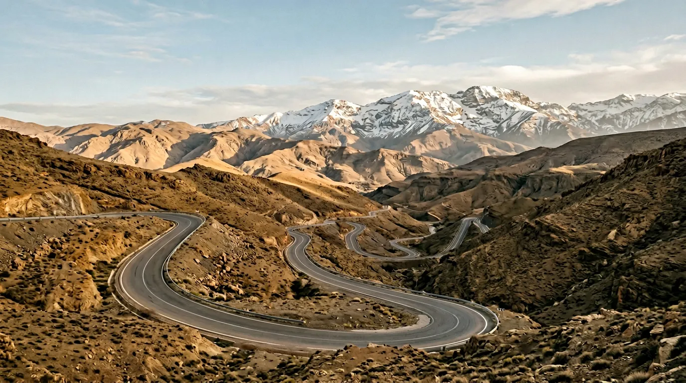
Morocco’s geography is organised by the Atlas Mountains, which run diagonally across the country from southwest to northeast. North of the Atlas is Mediterranean — green, agricultural, relatively mild. South of the Atlas is the pre-Saharan zone and then the desert proper. The mountains themselves are the transition, and crossing them is the fundamental act of Moroccan overland driving.
| Terrain type | Where you find it | Vehicle requirement |
|---|---|---|
| Mountain pass | High Atlas, Anti-Atlas | High-clearance 2WD for paved passes, 4x4 for detours |
| Desert piste (reg) | South of the Atlas, between ergs | 4x4 with low-range mandatory |
| Sand (erg) | Erg Chebbi (Merzouga), Erg Chigaga | 4x4 with low-range, deflated tires |
| Gorge road | Dades, Todra, smaller canyons | 2WD for main gorges, 4x4 for side canyons |
| Gravel road | Anti-Atlas, plateau areas | High-clearance 2WD |
The elevation range we drove spans from approximately 700 metres on the Sahara floor to 2,100 metres at the Tizi n’Test summit. The Anti-Atlas mountains further south reach lower elevations but offer extensive gravel networks that we have not yet documented.
Our documented routes
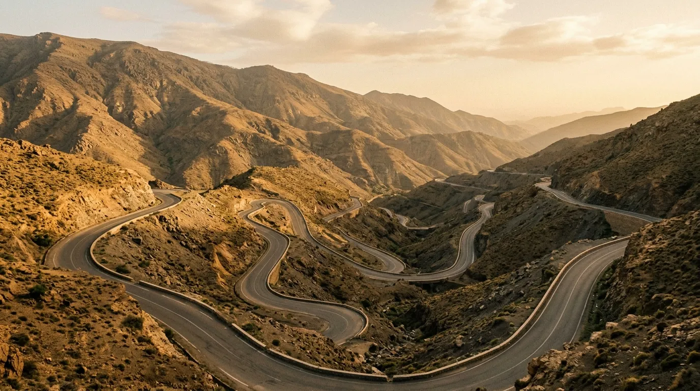
Tizi n’Test Pass
| **Catalog: TB-MA-001 | Difficulty: Moderate | Distance: 180 km | Duration: 1 day** |
The road that connects Marrakech to the Souss Valley via the western High Atlas. The pass itself tops out at 2,092 metres, and the road to get there is a continuous sequence of hairpin turns, blind corners, and single-lane sections with trucks coming the other way. The core road is paved, but it is narrow, exposed, and demanding enough to qualify as a mountain driving challenge. The dirt detours that branch off into argan forests and Berber villages add genuine off-road terrain. We drove it in a day, starting from Marrakech at dawn, and arrived at the southern side with a deep appreciation for the engineers who built it and the drivers who use it daily. Read the full route guide.
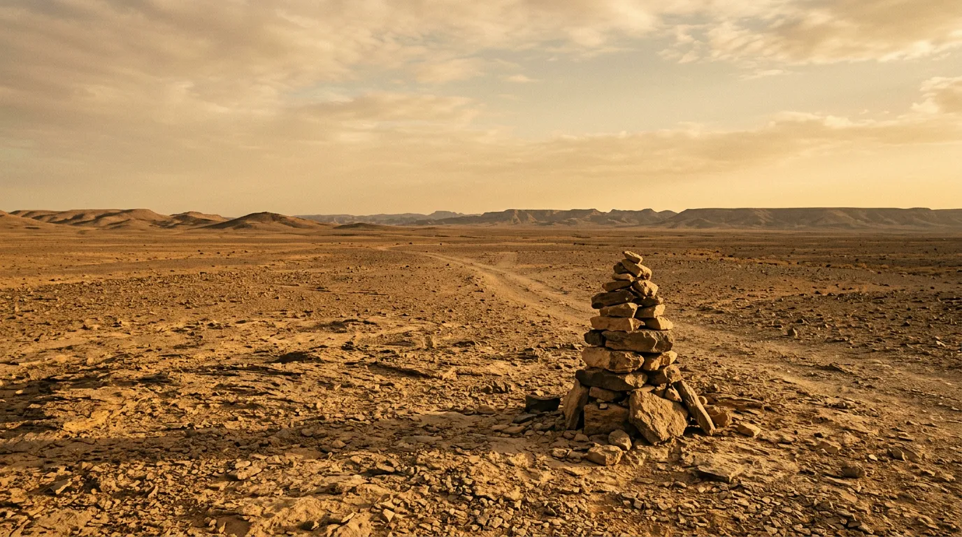
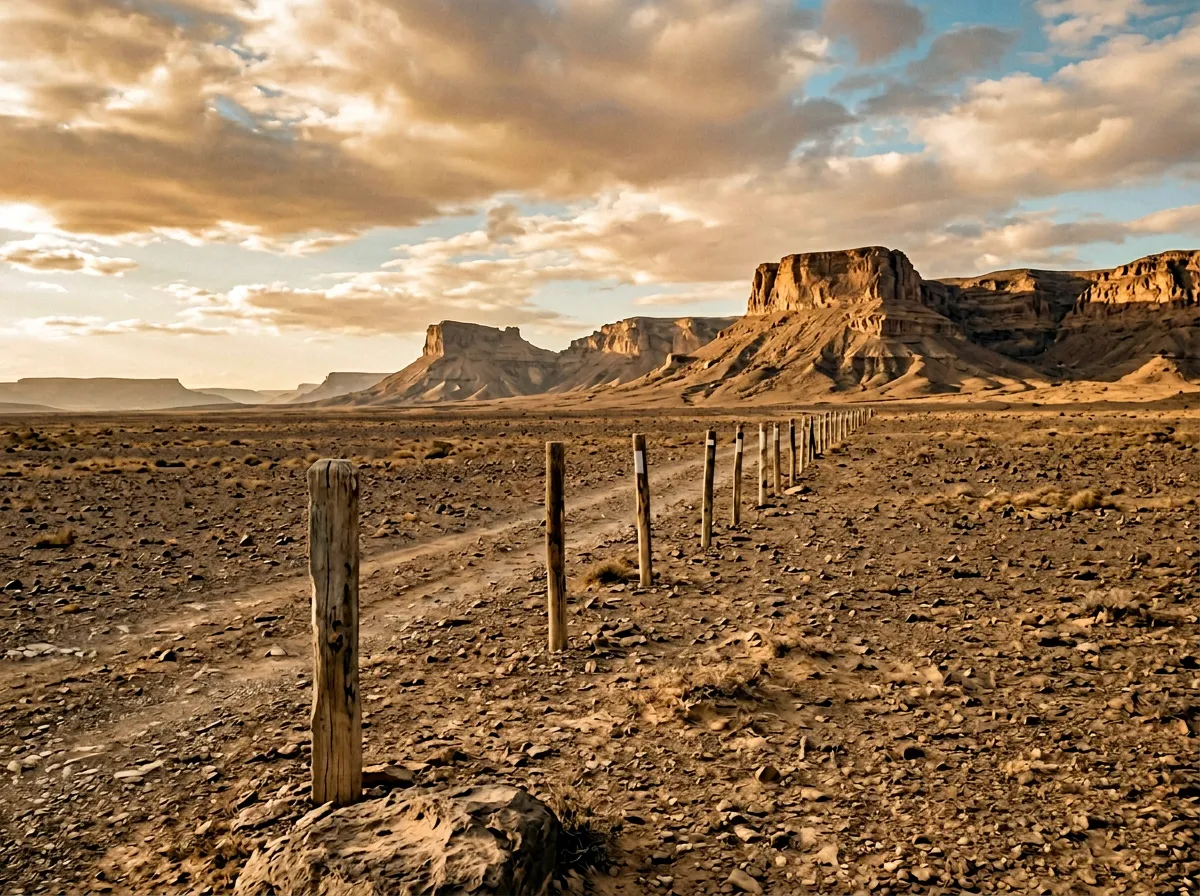
Sahara Piste: Merzouga to Zagora
| **Catalog: TB-MA-002 | Difficulty: Expert | Distance: 350 km | Duration: 2-3 days** |
This is the route that separates the enthusiasts from the tourists. 350 km of desert piste between Morocco’s two great erg towns, crossing reg (stone desert), dry lake beds, and sand sections that test your navigation, your vehicle preparation, and your willingness to be genuinely remote. The piste markers are sporadic and occasionally misleading. The fuel gap is 200 km. The nearest town of any size is a day’s drive away from the midpoint. We drove it in two and a half days and used every piece of recovery equipment we carried. It is the most demanding route we have documented in North Africa. Read the full route guide.
Dades and Todra Gorges
| **Catalog: TB-MA-003 | Difficulty: Easy | Distance: 140 km | Duration: 1-2 days** |
The accessible entry point for Morocco’s canyon driving. Two gorges connected by the Road of a Thousand Kasbahs, both with paved roads running through them and dirt tracks branching into side canyons. The Dades hairpins are the famous photograph — a zigzag road climbing through rock formations that look sculpted. The Todra narrows — 300-metre walls just 10 metres apart — are the engineering achievement. Both are driveable in a 2WD, which makes them the only route in our Morocco collection that does not demand a 4x4. The side canyons, however, are another story. Read the full route guide.
Practical information
Vehicle selection
Morocco has a well-established rental market. The practical choices are:
For mountain passes and gorges (Tizi n’Test, Dades, Todra): A Dacia Duster or similar high-clearance 2WD is sufficient for the main paved roads. For dirt detours and side canyons, you want a Suzuki Jimny or a Dacia Duster 4x4.
For the Sahara piste: A proper 4x4 with low-range transfer case is mandatory. Toyota Land Cruiser, Mitsubishi Pajero, or Nissan Patrol are the standard choices. Some agencies in Merzouga and Ouarzazate rent these specifically for desert use — expect to pay 500-800 MAD per day (approximately 45-75 EUR) for a capable vehicle.
Insurance note: Most rental agencies exclude desert driving from their insurance coverage. Read the fine print. Some agencies offer specific desert supplements; others simply will not rent you a vehicle for the Sahara piste. The agencies in Merzouga that cater to off-road travellers are your best bet.
Fuel planning
Morocco’s fuel network is good on paved roads and nonexistent in the desert. Fuel costs approximately 13-14 MAD per litre (about 1.20 EUR).
| Route | Last fuel | Next fuel | Gap |
|---|---|---|---|
| Tizi n’Test | Marrakech or Asni | Taroudant or Taliouine | ~100 km |
| Merzouga to Zagora | Merzouga | Zagora | ~200+ km |
| Dades and Todra | Boumalne Dades or Tinghir | Various small towns | ~60 km |
For the Sahara piste, carry a minimum of 20 litres of extra fuel in jerry cans. This is not optional.
Season and weather
Morocco is driveable year-round, but the seasons matter:
October to April: Best for desert routes. Comfortable temperatures in the Sahara (20-30 degrees by day, 5-15 at night). Mountain passes may have snow above 2,000 metres in December to February — Tizi n’Test occasionally closes for brief periods.
May to September: Mountain passes are at their best. The Atlas is green in spring (May-June) and the passes are fully clear. The Sahara, however, becomes dangerously hot — daytime temperatures exceed 45 degrees from June through August, and desert driving is not recommended.
The sweet spots: October-November and March-April, when both mountains and desert are accessible.
Permits and regulations
Morocco does not require driving permits for off-road travel. National park entry fees apply in some areas but are minimal (20-30 MAD per person). The gendarmerie maintains checkpoints on some desert approaches — they will check your documents (passport, vehicle registration, driver’s licence) and may ask about your route. This is routine, not adversarial.
International driving permits are technically required but inconsistently checked. Carry one regardless.
Connecting the routes
The three routes we have documented can be linked into a circuit starting and ending in Marrakech:
Day 1-2: Marrakech south over Tizi n’Test to the Souss Valley. Continue east along the Anti-Atlas roads to Ouarzazate (paved, approximately 300 km).
Day 3-4: Ouarzazate east to the Dades and Todra Gorges. Drive both gorges with side-canyon detours. Continue east to Merzouga (paved, approximately 200 km from Tinghir).
Day 5-7: Merzouga to Zagora Sahara piste. Two to three days of desert driving.
Day 8: Zagora north to Ouarzazate (paved, approximately 170 km), then over the Tizi n’Tichka pass back to Marrakech (paved, approximately 200 km).
Total circuit: approximately 8-10 days, covering mountain, gorge, and desert terrain. This is the classic Moroccan overland route, and for good reason — it packs three distinct landscapes into a single loop.
Field notes
Morocco is not a difficult country to travel in. The infrastructure is better than most visitors expect — paved roads are generally good, fuel is available in every town, and accommodation ranges from basic roadside auberges to comfortable riads. The difficulty is concentrated on the off-road sections, where the gap between paved Morocco and unpaved Morocco is as dramatic as the geography.
The human landscape matters as much as the physical one. The Berber villages in the Atlas Mountains and the desert communities south of the range are welcoming to travellers, and the tradition of roadside hospitality — tea, directions, mechanical advice — is genuine. We received more useful route information from a shopkeeper in Alnif than from any guidebook, and a Berber farmer near Tizi n’Test adjusted our tire pressure for the mountain descent without being asked.
French is widely spoken in southern Morocco and is the practical language for navigation, mechanical help, and accommodation booking. Arabic is official. English is less common outside tourist centres. A few phrases of French will serve you well.
Related regions
Morocco’s combination of mountain and desert driving has parallels in several countries we cover. Jordan offers similar desert terrain but in a more compact package — Wadi Rum and the Dana canyon are smaller in scale but equally dramatic. Oman combines desert sand driving with mountain roads in a way that echoes the Atlas-to-Sahara transition. Namibia is the closest equivalent in terms of scale — vast desert driving distances, gravel roads as the primary infrastructure, and a landscape that demands self-sufficiency.
Ground clearance, tire type, and 4x4 lock differ between agencies. Compare before you book.