South Africa
Route Specimens
3 routes surveyed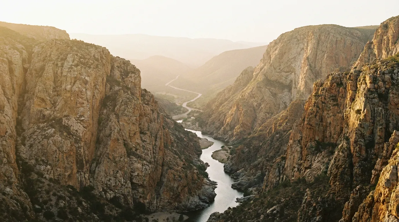
South Africa Off-Road Routes
South Africa is where off-road driving in Africa grew up. While other countries on the continent offer wilder terrain or more remote wilderness, South Africa has something none of them can match: a century-old tradition of building roads through landscapes that have no business being crossed by vehicles. The mountain passes of the Western Cape were graded by ox-wagon before they were graded by machine. The gorge tracks of the Eastern Cape follow hunting paths that are older than the colony. The desert routes of the Northern Cape run through terrain that the Khoisan navigated on foot for thirty thousand years before anyone thought to attach an engine to four wheels and point it at the horizon.
We have driven three routes across the country’s off-road terrain: the 200 km gorge crossing of Baviaanskloof, the vertical ascent of Sani Pass into Lesotho, and the desert loop through the Richtersveld along the Orange River. Between them, they cover an elevation range from sea level to nearly 3,000 metres and terrain that spans subtropical gorge, alpine escarpment, and succulent desert. This is a country that compresses geological variety into driveable distance.
Terrain classification
South Africa’s geology is old. The rocks in the Richtersveld are among the oldest exposed formations on Earth — over two billion years, which is a number that means nothing until you are standing on them and the landscape looks like a planet that has not yet decided whether it wants to support life. The Drakensberg escarpment, by contrast, is a layer cake of basalt and sandstone that records the breakup of Gondwana. You can read continental drift in the cliff faces on Sani Pass, if you can spare the attention from the switchbacks.
| Terrain type | Where you find it | Vehicle requirement |
|---|---|---|
| Mountain pass | Sani Pass, Swartberg, Bain’s Kloof | 4x4 with low-range for major passes |
| Gorge gravel | Baviaanskloof, Meiringspoort | 4x4 with high clearance |
| River crossing | Baviaanskloof, Eastern Cape | 4x4 recommended; depth varies seasonally |
| Desert track | Richtersveld, Tankwa Karoo | 4x4 recommended, high-clearance 2WD in dry conditions |
| Bushveld track | Limpopo, Mpumalanga | High-clearance 2WD minimum |
The country sits at the convergence of three oceans’ weather systems — Atlantic, Indian, and Southern — which means conditions vary dramatically across short distances. The Western Cape gets its rain in winter. The Eastern Cape gets it in summer. The Northern Cape barely gets it at all. This is not academic — it determines when each route is passable and when it will try to kill you.
Our documented routes
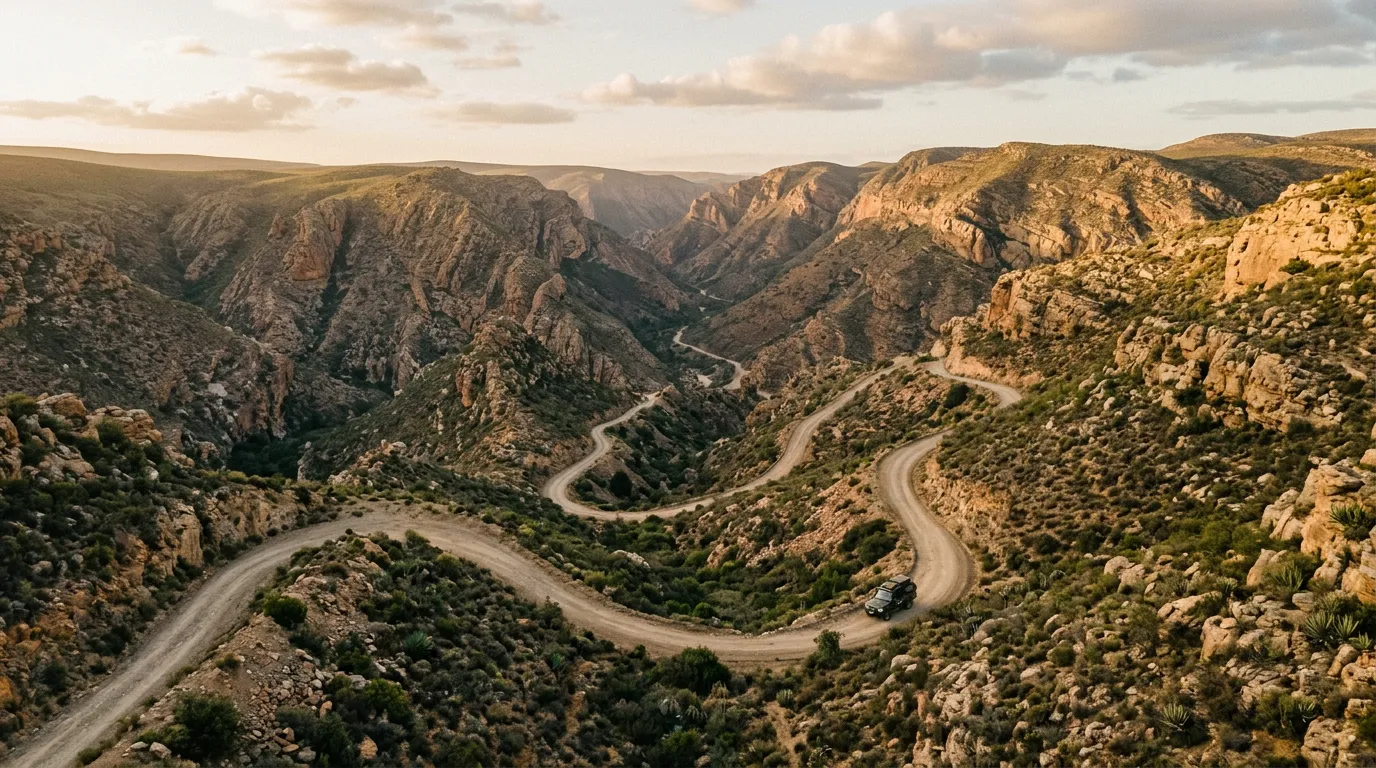
Baviaanskloof
| **Catalog: TB-ZA-001 | Difficulty: Challenging | Distance: 200 km | Duration: 2-3 days** |
The Baviaanskloof Mega Reserve is a UNESCO World Heritage buffer zone containing a 200 km gorge track with fourteen river crossings, no cell signal, and the kind of stargazing that makes you reconsider your life choices regarding where you live. The route runs east-west through a gorge that narrows to a few hundred metres in places, with vertical cliffs rising on both sides and a river that crosses the road with a regularity that suggests the road-builders gave up trying to avoid it. In dry season, the crossings are ankle-deep and scenic. In wet season, they are impassable and dangerous. We drove it in May and had perfect conditions. Read the full route guide.
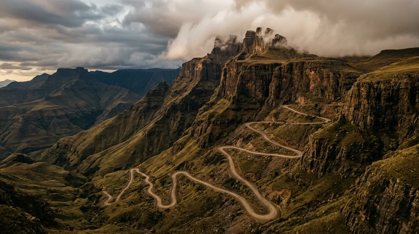
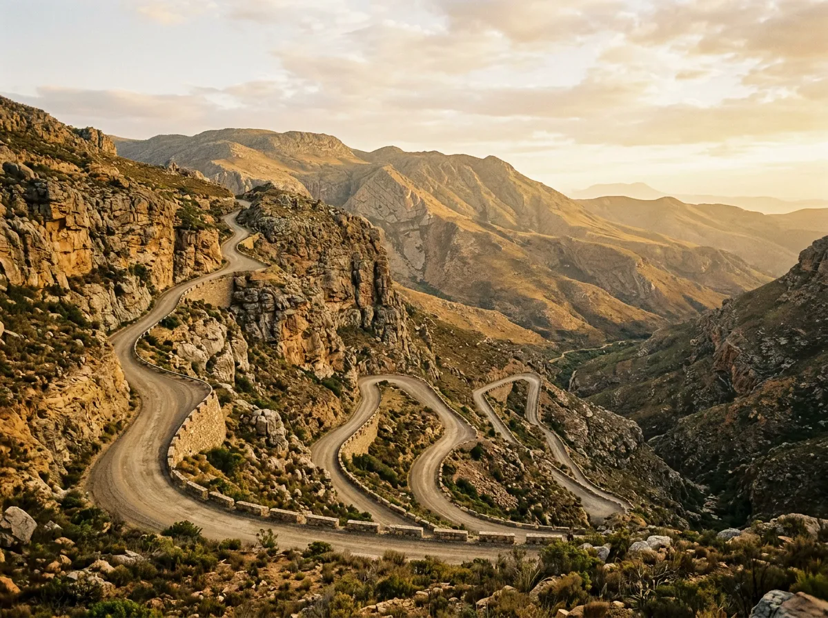
Sani Pass
| **Catalog: TB-ZA-002 | Difficulty: Challenging | Distance: 33 km | Duration: Half day** |
Sani Pass is the steepest gravel road pass in southern Africa: 33 km of switchbacks climbing 1,300 metres up the Drakensberg escarpment from KwaZulu-Natal into the Kingdom of Lesotho. Low-range 4x4 is legally required — border officials at the base will check your vehicle and turn you away if it does not qualify. The pass is narrow, steep, and occasionally terrifying, with blind corners and a gradient that makes your transmission work harder than it has ever worked. At the top, there is a pub that claims to be the highest in Africa. We did not verify this claim, but we drank a beer there and felt that altitude had been earned. Read the full route guide.
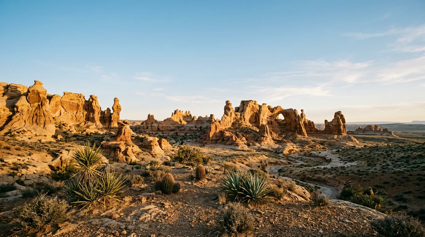
Richtersveld Loop
| **Catalog: TB-ZA-003 | Difficulty: Moderate | Distance: 160 km | Duration: 2-3 days** |
The Richtersveld is South Africa’s contribution to the category of landscapes that look like other planets. Succulent desert, rock formations weathered into shapes that suggest geological hallucination, and the Orange River carving a canyon through terrain that has not changed meaningfully in a hundred million years. The driving is moderate by South African off-road standards — mainly gravel tracks and rocky passes — but the remoteness is real. Summer temperatures exceed 45 degrees Celsius. There is no potable water on the route. The nearest assistance is hours away. This is a winter destination, and a rewarding one. Read the full route guide.
Practical information
Vehicle selection
The minimum vehicle for these routes depends on which one you are attempting. Sani Pass has a legal minimum: 4x4 with low-range transfer case. The border post at the bottom enforces this, and we watched a family in a Hyundai Tucson get turned away with the kind of gentle finality that suggested it happened several times a day. For Baviaanskloof, a 4x4 with high clearance is the practical minimum — the river crossings demand it, and the rocky sections between crossings are unkind to low-slung vehicles. The Richtersveld is the most forgiving: a high-clearance 2WD will manage in dry conditions, though a 4x4 gives you access to the more interesting side tracks.
Rental agencies in Cape Town, Durban, and Johannesburg all offer 4x4 vehicles. The most common are Toyota Hilux and Toyota Fortuner. Some agencies explicitly allow gravel road driving; others do not. Read the rental agreement before you sign, and ask about the excess on undercarriage damage.
Fuel planning
South Africa’s fuel network is extensive on tarred roads and sparse off them. Each route has its own fuel calculus.
| Route | Last reliable fuel | Next fuel | Gap |
|---|---|---|---|
| Baviaanskloof (westbound) | Willowmore | Patensie | ~200 km |
| Baviaanskloof (eastbound) | Patensie | Willowmore | ~200 km |
| Sani Pass | Underberg or Himeville | Mokhotlong (Lesotho) | ~80 km |
| Richtersveld | Port Nolloth or Springbok | Port Nolloth or Springbok | ~200 km |
Carry a minimum 20L jerry can for Baviaanskloof and the Richtersveld. Sani Pass is short enough that a full tank will suffice.
Season and weather
South Africa’s off-road season varies by region. The Eastern Cape (Baviaanskloof) is best April to October — dry season, when river crossings are manageable. Sani Pass is driveable year-round but snow is possible June through August, and ice on the upper sections makes the pass significantly more dangerous. The Richtersveld is strictly a winter destination: April to September. Summer temperatures in the Northern Cape regularly exceed 45 degrees Celsius, which is beyond what is sensible for vehicle or driver.
Permits and access
Baviaanskloof: free entry, but you must register at the gates (Willowmore side or Patensie side). Gates close at 17:00. The Makkedaat Caves campsite inside the gorge must be booked through CapeNature. The Richtersveld requires a SANParks permit and campsite booking — there are only four campsites inside the park, and they fill up months in advance in peak season (June to August). Sani Pass requires a valid passport — you are crossing an international border into Lesotho at the summit.
Field notes
South Africa’s off-road infrastructure is unusually mature. The passes have been maintained for over a century. The gorge tracks are graded annually. The national parks system (SANParks and CapeNature) provides reliable information on road conditions — phone the relevant park office before departing and they will tell you which crossings are passable and which are not. This is a level of institutional support that you will not find in most African countries, and it is worth using.
The driving culture is also established. South Africa has a large and knowledgeable 4x4 community, and the forums (4x4community.co.za is the main one) contain route reports that are often more detailed and more current than anything in a guidebook. Check the forum for your route before you go.
That said, South Africa is not a country where off-road driving is risk-free. The remoteness on Baviaanskloof and the Richtersveld is real — no cell signal, no passing traffic, no rescue services within practical distance. Carry what you need. Tell someone your itinerary. And respect the river crossings: a South African river that looks calm at the surface can have a current underneath that will move a vehicle sideways faster than you can react.
Water: 5 litres per person per day for the Richtersveld. 3 litres per person per day for Baviaanskloof (the river water is not potable but you are not in desert). Sani Pass is a day trip — carry a litre per person and lunch.
Related regions
South Africa’s off-road routes connect naturally to Namibia — the Richtersveld is essentially the South African side of a landscape that continues north into the Namib Desert. For a different kind of African driving, Tanzania offers savanna tracks and river crossings through wildlife-rich national parks. And for extreme highland terrain with minimal infrastructure, Ethiopia is the most challenging driving we have documented on the continent.
Ground clearance, tire type, and 4x4 lock differ between agencies. Compare before you book.