Iceland
Route Specimens
3 routes surveyed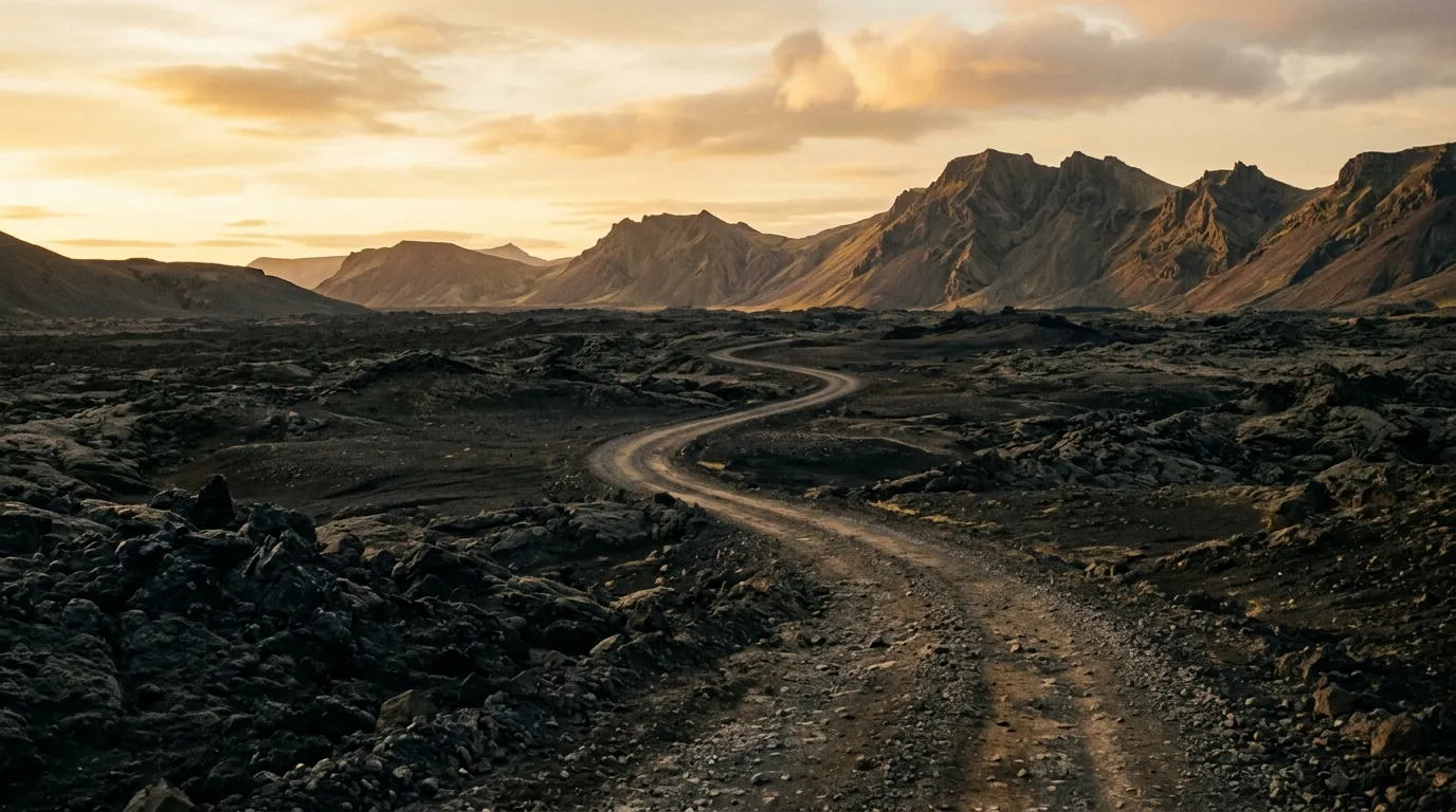
Iceland Off-Road Routes
Iceland is the only country on our list where off-road driving is illegal. We should clarify: driving off established roads and tracks is illegal. The F-roads — Iceland’s network of unpaved highland routes — are legal, designated, and open seasonally to 4x4 vehicles. Driving one metre to either side of these tracks, however, is a crime punishable by fines that start at 500,000 ISK (approximately 3,500 USD) and escalate from there. The reason is the moss. Icelandic moss takes decades to grow and can be destroyed by a single tire track. The Icelanders are protective of it, and they are right to be.
This distinction matters because it changes what “off-road driving in Iceland” means. In Georgia or Morocco, you are free to pick a line through open terrain, to deviate around obstacles, to explore a wadi or a steppe at your own discretion. In Iceland, you drive the tracks and only the tracks. The tracks, however, cross some of the most extraordinary terrain we have driven anywhere — volcanic deserts, glacial outwash plains, geothermal fields, and river fords that test your vehicle, your judgment, and your willingness to commit to a crossing with water above your bumper.
We have driven three routes in Iceland’s highland interior: the F35 Kjolur highland route between the glaciers, the F26 Sprengisandur crossing through the black desert, and the Askja caldera track to the volcanic interior. Between them, they cover the full range of what Iceland’s F-road network offers — from the relatively accessible Kjolur (no river fords) to the demanding Askja track (deep river fords, lava fields, and a geothermal lake inside a volcano).
Terrain classification
Iceland’s terrain is young. Geologically speaking, the island surfaced from the Mid-Atlantic Ridge approximately 18 million years ago and has been reshaping itself with volcanic eruptions, glacial advances, and erosive weather ever since. The highland interior is the result: a vast, treeless plateau of volcanic sand, lava fields, and glacial rivers, sitting at 500 to 1,000 metres elevation between the two largest ice caps in Europe.
| Terrain type | Where you find it | Vehicle requirement |
|---|---|---|
| Gravel highland road | Kjolur (F35), most F-road approaches | 4x4 required (legally mandated) |
| Volcanic sand desert | Sprengisandur (F26), Askja approach | 4x4 with good clearance |
| Lava field track | Askja (F88/F910), Landmannalaugar approach | 4x4 with high clearance |
| River ford | Sprengisandur, Askja, multiple F-roads | 4x4 with snorkel preferred for deep crossings |
| Glacial outwash plain | Approaches to Vatnajokull, Langjokull | 4x4, watch for soft sand |
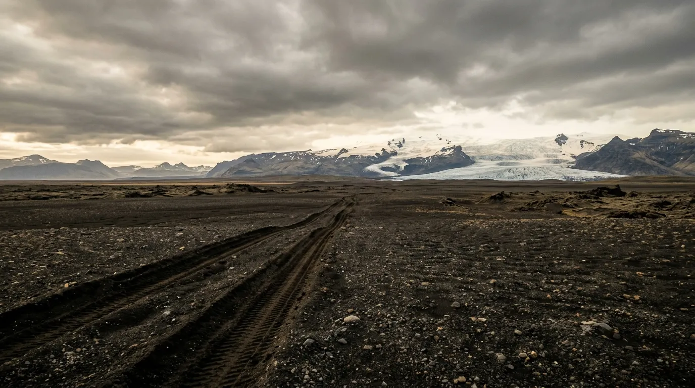
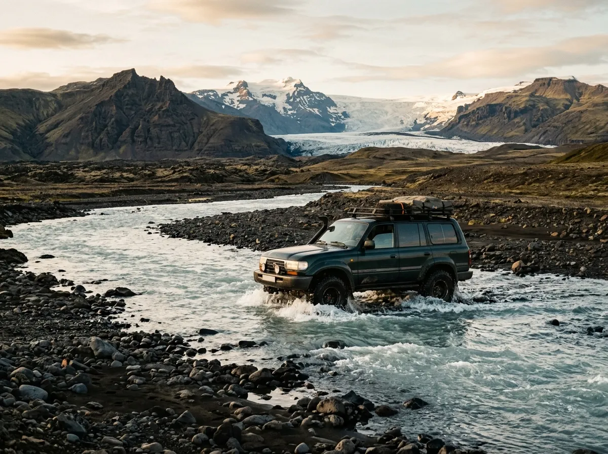
The river fords are the defining feature of Icelandic highland driving. Glacial rivers are fed by meltwater, which means their depth and flow rate change throughout the day — lowest in the morning before the sun hits the glacier, highest in the late afternoon after a full day of melting. Crossing a river at 8:00 AM and crossing the same river at 4:00 PM are two different propositions. We have seen rivers rise 30 cm in the space of a few hours.
Our documented routes
F35 Kjolur Highland Route
| **Catalog: TB-IS-001 | Difficulty: Moderate | Distance: 200 km | Duration: 1 day** |
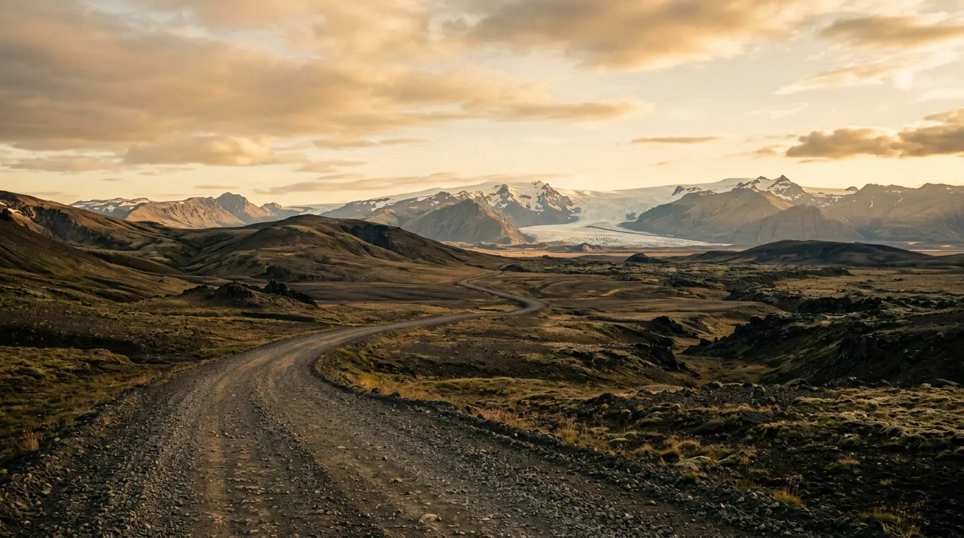
The entry-level highland route and the one we recommend for first-time F-road drivers. Kjolur runs 200 km between Gullfoss (the famous waterfall) and Blonduos on the north coast, passing between the Langjokull and Hofsjokull glaciers through volcanic desert and geothermal fields. The crucial advantage for beginners: no river fords. The route crosses bridges over every significant waterway, which removes the single most intimidating element of highland driving. The surface is gravel, the terrain is dramatic, and the Hveravellir hot springs at the midpoint offer a geothermal pool in the middle of a desert. If you have never driven an F-road, start here. Read the full route guide.
F26 Sprengisandur
| **Catalog: TB-IS-002 | Difficulty: Challenging | Distance: 200 km | Duration: 1 long day** |
The quintessential Icelandic highland crossing. Sprengisandur runs 200 km through the volcanic desert between Hofsjokull and Vatnajokull — the two largest glaciers in Iceland — across terrain that looks like the surface of another planet and feels like it too. There is nothing here. No buildings, no trees, no power lines, no mobile signal. There are river fords, including several that require assessment before crossing. There is Nyidalur, a mountain hut that represents the only shelter in 200 km. And there is the landscape: black sand, grey sky, white ice on the horizon, and the overwhelming sensation of being the only human beings on Earth. This is what people mean when they say Iceland’s interior. Read the full route guide.
Askja Caldera Track
| **Catalog: TB-IS-003 | Difficulty: Challenging | Distance: 100 km | Duration: 1 long day (return trip)** |
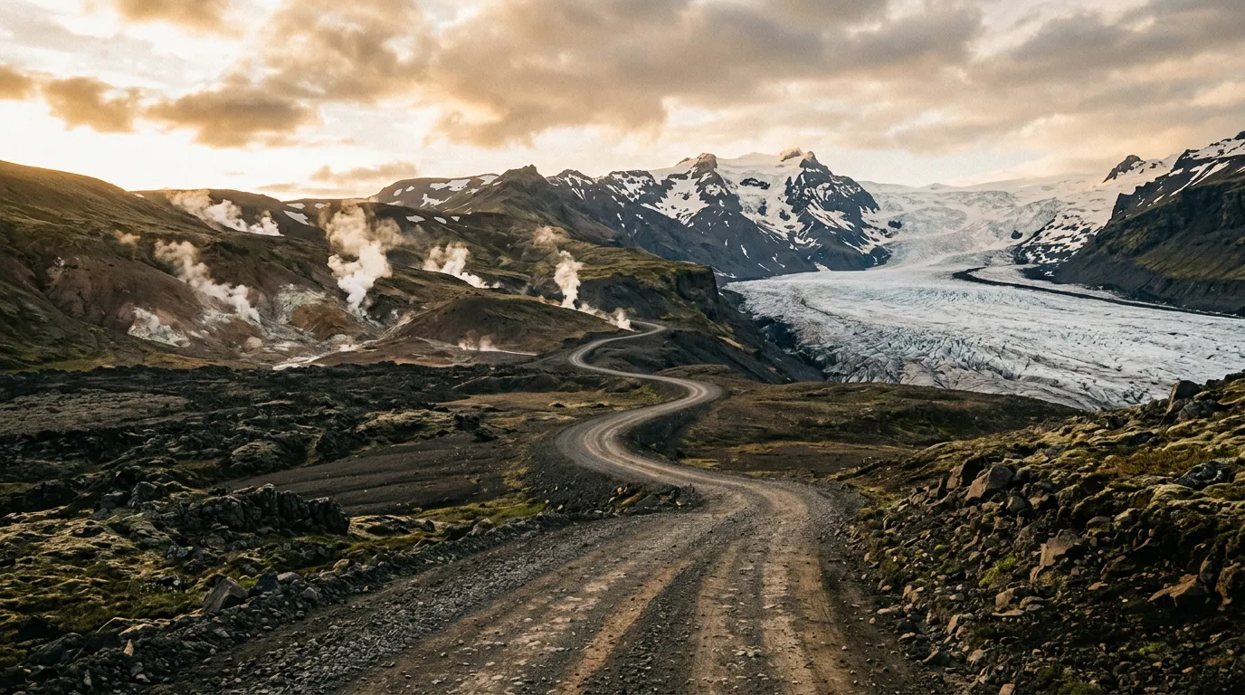
The most committed drive on our Iceland list. The F88 and F910 lead from the highland road system to the Askja caldera — a volcanic crater containing a 217-metre-deep lake and a geothermal crater (Viti) that is sometimes warm enough to swim in. The route crosses lava fields, black sand, and the Jokulsa a Fjollum river — a glacial river ford that is the crux of the entire route and has stopped many vehicles. The caldera itself is worth the effort: standing inside a volcano, looking at a lake that did not exist 150 years ago, with steam rising from the crater next to it. The road is open approximately six weeks per year. Read the full route guide.
Practical information
Vehicle requirements: the law
Iceland requires a 4x4 for all F-roads. This is not a recommendation — it is a legal requirement. Rental agencies geofence their vehicles and will know if you take a 2WD onto an F-road. Insurance is voided. Fines are issued. The rental agency will charge you for any damage, and the Icelandic police will charge you for the privilege of being caught.
Rent a proper 4x4. The Suzuki Jimny, Dacia Duster, and similar small 4x4s are legally sufficient for Kjolur but marginal for river fords. For Sprengisandur and Askja, we recommend a vehicle with a snorkel or at minimum adequate intake height — a Toyota Land Cruiser, Mitsubishi Pajero, or similar. Iceland’s rental market specialises in highland-capable vehicles, and the premium for a proper 4x4 over a basic one is money well spent.
River fording: the basics
| Principle | Detail |
|---|---|
| Time of day | Cross in the morning. Glacial rivers rise throughout the day. |
| Test first | Walk the crossing (in waterproof boots) to check depth and bottom. |
| Speed | Slow and steady. Create a bow wave but do not splash water into the engine. |
| Line | Angle upstream into the current. Cross at the widest, shallowest point. |
| Depth limit | If water reaches your door sills, stop and reconsider. |
| After crossing | Stop and check. Water in the brakes needs to be dried (drive slowly with slight brake pressure). |
River fording is a skill. If you have never done it, practice on a known shallow crossing first — not on a glacial river in the middle of the Sprengisandur desert.
Fuel planning
The highland interior has no fuel. Zero. The last fuel station before each route is on the Ring Road, and the next one is on the Ring Road on the other side. Plan accordingly.
| Route | Last fuel (south) | Last fuel (north) | Total distance no fuel |
|---|---|---|---|
| Kjolur (F35) | Geysir/Gullfoss area | Blonduos | ~200 km |
| Sprengisandur (F26) | Hrauneyjar | Godafoss area | ~250 km |
| Askja (F88/F910) | Myvatn area | Myvatn area (return) | ~200 km round trip |
Carry a jerry can for any route. Highland driving increases fuel consumption by 20-40 percent compared to ring road driving. Do not rely on the number your dashboard fuel range estimator displays — it was calibrated for paved roads.
Season and road openings
F-roads open when they are passable and close when they are not. The government maintains a road condition website (road.is) that shows the status of every F-road in the country. Check it before you drive. Check it again on the morning of your drive. Conditions change.
| Route | Typical opening | Typical closing | Open period |
|---|---|---|---|
| Kjolur (F35) | Mid-to-late June | Late September | ~3 months |
| Sprengisandur (F26) | Late June – early July | Early September | ~2 months |
| Askja (F88/F910) | Early-to-mid July | Late August | ~6 weeks |
These dates vary by year. Early snow, late thaw, or volcanic activity can shift them significantly. The 2010 Eyjafjallajokull eruption closed several highland routes for an entire season. Iceland is geologically active. Respect this.
Weather
Icelandic weather in the highlands is not weather in the conventional sense. It is a series of events that happen to your vehicle and your morale in rapid succession. Sun, rain, wind, fog, and hail can occur within a single hour. The temperature at 700 metres elevation in July ranges from 5 to 15 degrees Celsius. Wind can exceed 80 km/h without warning.
Carry warm clothing, waterproof layers, and a hat regardless of the forecast. The forecast is a suggestion, not a commitment.
Field notes
The highland interior is empty in a way that is difficult to describe from experience in other countries. We have driven desert routes in Namibia, steppe routes in Georgia, and remote tracks in Ethiopia. None of them prepared us for the specific quality of Icelandic emptiness, which is not just the absence of people but the absence of life — no trees, no grass (in the true desert sections), no birds, no evidence that any living thing has ever considered this a reasonable place to be. It is austere and beautiful and profoundly humbling.
The environmental regulations are strict because the environment is fragile. Tire tracks on moss last for decades. Human waste does not decompose at these temperatures. If you stop, stay on the track or on bare rock. If you need a toilet, use the facilities at the mountain huts or pack a portable system. This is not optional. The Icelanders will find you and they will fine you and they will be correct to do so.
Mobile coverage in the highlands is essentially nonexistent. Download offline maps. Carry a physical map as backup. A satellite communicator is strongly recommended for Sprengisandur and Askja — not because these routes are inherently dangerous, but because help is very far away if something goes wrong.
The mountain huts (managed by Ferdalag Islands, fi.is) are the highland accommodation system. They offer bunk beds, basic cooking facilities, and occasionally a warden. Book ahead for summer. The huts at Hveravellir (Kjolur) and Nyidalur (Sprengisandur) are the key stops on our routes.
Related regions
If Iceland’s volcanic highland driving appeals to you, Georgia offers a different kind of highland experience — mountain passes in the Caucasus with more vegetation, more human presence, and significantly less regulation. Ethiopia has volcanic terrain and highland circuits at altitude. Namibia shares the vast, empty desert character with more varied wildlife and considerably warmer temperatures.
Ground clearance, tire type, and 4x4 lock differ between agencies. Compare before you book.