Romania
Route Specimens
3 routes surveyed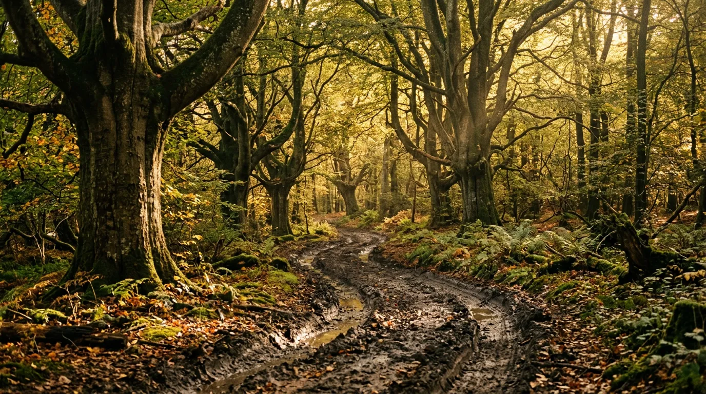
Romania Off-Road Routes
Romania is the country where the distinction between “off-road” and “on-road” matters least. The Transfagarasan and Transalpina are paved mountain passes — some of Europe’s finest, in fact — but their real value to us is as access roads. They carry you to 2,000 metres of altitude on smooth asphalt, and from there, unpaved tracks branch into the Carpathian forests where the landscape shifts from scenic tourism to something older and wilder. The bears are real. The mud is real. The logging trucks barrelling down single-lane forest roads at speeds that defy their mass are very real.
We drove three categories of route in Romania: the two famous mountain passes with their unpaved extensions, a network of Carpathian forest tracks in the Fagaras and Piatra Craiului ranges, and a handful of connecting tracks that stitch these together into multi-day itineraries. The result is the most varied off-road driving in Europe south of Scandinavia, accessible from Bucharest in half a day of driving and manageable in vehicles ranging from a Dacia Duster to a full-specification 4x4.
Romania’s Carpathians are also the most forgiving introduction to mountain off-road driving in our catalogue. The forest tracks are muddy but not usually steep. The gradients are moderate. The surfaces are soft earth rather than sharp rock. If you are new to driving on unpaved surfaces, Romania is a better starting point than Albania, Montenegro, or Georgia, because the penalties for mistakes are lower. You get stuck in mud, not stuck on a cliff.
Terrain classification
The Carpathians form a 1,500 km arc through Romania, creating a natural barrier between the Transylvanian plateau and the lowlands of Wallachia and Moldavia. The off-road terrain concentrates along the crest of this arc, where the forests begin and the pavement ends.
| Terrain type | Where you find it | Vehicle requirement |
|---|---|---|
| Paved mountain pass | Transfagarasan (DN7C), Transalpina (DN67C) | 2WD (any car) |
| Alpine gravel extension | Pass shoulders, seasonal roads above 1,800m | High-clearance 2WD |
| Forest logging track | Fagaras range, Piatra Craiului, Bucegi | 4x4 recommended |
| Stream crossing | Most forest tracks | 4x4 with clearance |
| Mud section | Forest tracks after rain | 4x4 with good tires |
The Romanian Carpathians are lower than the Caucasus or the Alps — the highest point is 2,544 metres — but their forest cover is denser and older. The Carpathians contain 65 percent of Europe’s remaining old-growth forest, and driving through it feels materially different from the bare alpine passes of Montenegro or Albania. Here, the trees press in on both sides, the light filters through canopy, and the surface underfoot is soft forest earth rather than exposed rock.
Our documented routes
Transfagarasan and Its Side Tracks
| **Catalog: TB-RO-001 | Difficulty: Easy | Distance: 150 km | Duration: 1-2 days** |
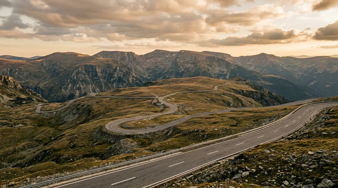
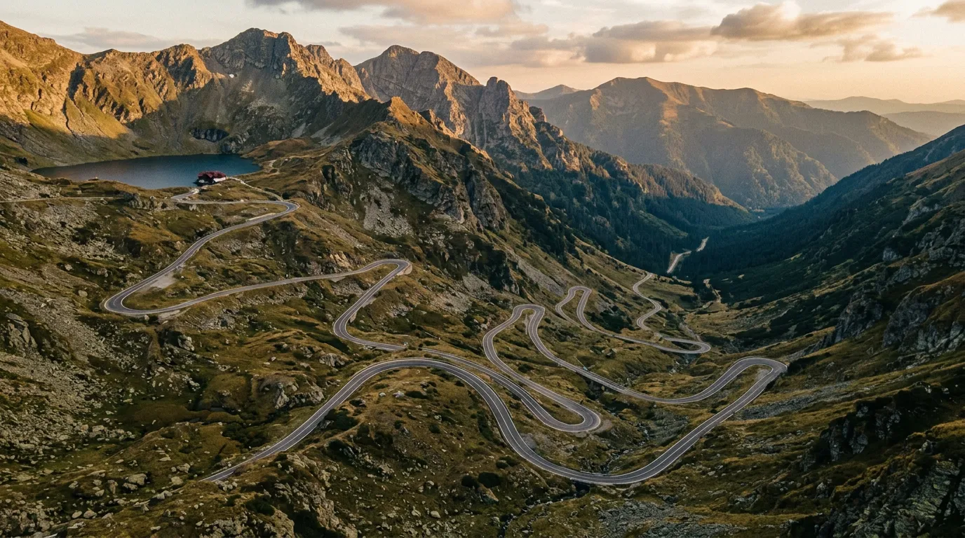
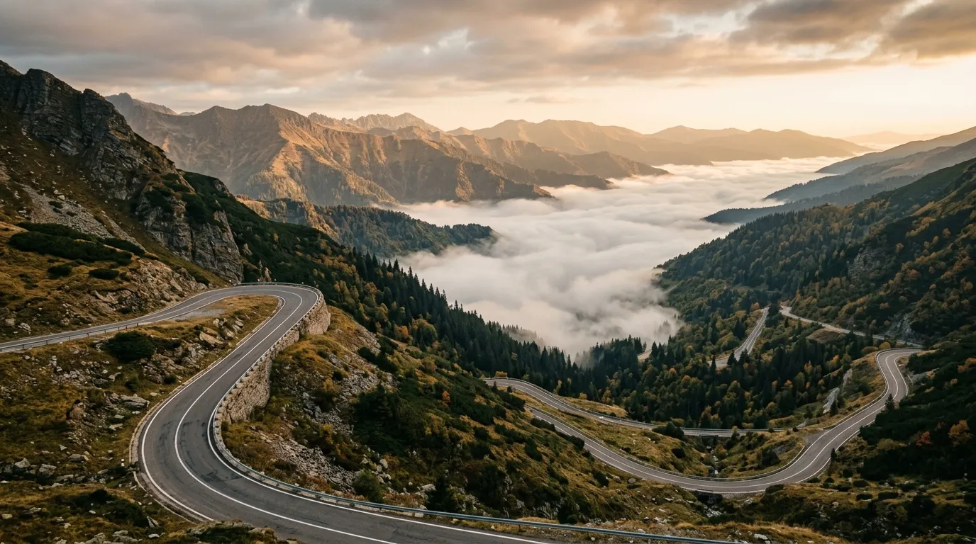
The Transfagarasan (DN7C) is the road Jeremy Clarkson called “the best road in the world,” which ensures a steady stream of sports car traffic on summer weekends. The road is genuinely spectacular — 150 km of mountain highway climbing to 2,042 metres at Balea Lake, with hairpin switchbacks, tunnels, and cascading views. But the adjacent forestry tracks on both flanks of the Fagaras range are where the off-road driving begins. Side roads to glacial lakes, shepherd pastures, and remote forest clearings branch off the main road throughout its length, accessible to anyone willing to leave the asphalt. Read the full route guide.
Transalpina
| **Catalog: TB-RO-002 | Difficulty: Moderate | Distance: 130 km | Duration: 1 day** |
Romania’s highest road tops out at 2,145 metres — higher than the Transfagarasan and less crowded. The DN67C crosses the Parang Mountains with sections of seasonal gravel that extend the paved road into genuine off-road territory. The summit section is exposed alpine terrain: no trees, no shelter, grass and rock and sky. Seasonal extensions — tracks that are passable only from July to September — continue where the pavement ends, reaching viewpoints and pastures that the paved road only hints at. Read the full route guide.
Carpathian Forest Tracks
| **Catalog: TB-RO-003 | Difficulty: Moderate | Distance: 80 km | Duration: 1 day** |
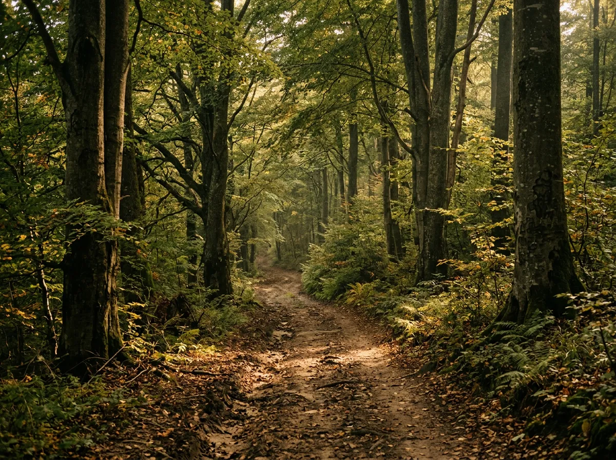
The logging roads of the southern Carpathians: a network of forest tracks that wind through old-growth beech and spruce forest, crossing streams, skirting clearings, and passing through terrain that is home to Europe’s largest brown bear population. The tracks are muddy, narrow, and alive with things that are not vehicles. This is where Romania’s off-road character is most distinct — soft, green, wet, and populated by wildlife that takes priority. Read the full route guide.
Practical information
Vehicle selection
Romania has the best vehicle-to-route match in our European catalogue. The Dacia Duster — literally a Romanian-manufactured vehicle — is available at every rental agency in the country and handles most of what we cover. The 2WD Duster is adequate for the paved passes and light gravel. The 4x4 Duster handles the forest tracks in dry conditions. For serious mud or post-rain forest driving, a heavier 4x4 (Jimny, Tucson 4WD) provides extra security but is rarely essential.
The Duster 4x4 rents for approximately 35-60 EUR per day in Bucharest. The Jimny, when available, is similar. Full-size 4x4s (Pajero, Land Cruiser) are rare in Romanian rental fleets and significantly more expensive.
Fuel planning
Romania’s fuel network is excellent. Even small Carpathian towns have fuel stations, and the mountain passes have fuel available at their base villages. The longest fuel gap on our routes is approximately 80 km (the forest tracks section), and even this is manageable in a Duster with its 50L tank.
| Route | Last reliable fuel | Next fuel | Gap |
|---|---|---|---|
| Transfagarasan | Curtea de Arges (south) or Cartisoara (north) | Multiple options | ~60 km max from pass summit |
| Transalpina | Sebes (north) or Novaci (south) | Multiple options | ~50 km max |
| Forest tracks | Varies by route. Brasov area is well-served. | ~80 km max | Carry 10L jerry for deep forest routes |
Season and weather
The mountain passes have official opening dates that vary by year. The Transfagarasan typically opens in late June and closes in late October. The Transalpina opens slightly earlier (early June) and closes similarly. Forest tracks at lower elevations are accessible from May to October, though spring mud extends into June.
Romanian summer weather in the mountains is warm (20-25 degrees Celsius during the day at pass altitude) with frequent afternoon thunderstorms from June through August. Rain makes the forest tracks significantly more difficult — the soft earth absorbs water and becomes slippery mud within an hour of a storm. If you are driving forest tracks and the sky darkens by noon, consider heading for pavement.
Bears
Romania has approximately 7,000 brown bears, the largest population in Europe outside Russia. The bears live primarily in the Carpathian forests, which is also where our forest tracks run. Encounters are not daily but they are not uncommon. Our Carpathian Forest Tracks guide includes bear-encounter protocol, but the summary is: stay in the vehicle, do not feed bears, do not leave food at campsites, and do not approach bears on foot regardless of how photogenic they appear.
Field notes
Bucharest to the Carpathians is a 2-3 hour drive on improving highways. Sibiu, Brasov, and Curtea de Arges are the most useful base towns for our routes — all have fuel, accommodation, supermarkets, and mechanics who understand what “I drove on a forest road” means when you show them the undercarriage.
The Romanian forestry road network is immense — far more extensive than our documented routes suggest. Thousands of kilometres of logging tracks exist throughout the Carpathians, and local enthusiasts have spent years mapping them on OsmAnd and other platforms. If you have time beyond our three routes, ask locally about tracks in the Apuseni Mountains (western Carpathians), which we have not yet driven but which reportedly offer excellent forest driving at slightly lower altitudes.
Romanian drivers are fast on mountain roads. The paved passes attract motorcyclists and sports car drivers who use them as circuits, and the sight lines on switchbacks are not always adequate for the speeds involved. On the Transfagarasan in particular, drive defensively and stay right on blind corners.
Mobile coverage is reliable in towns and along the paved passes. In the deep forest, coverage drops to zero. OsmAnd offline maps are essential.
Related regions
Romania pairs well with Bosnia and Herzegovina for a multi-country Balkan off-road itinerary — the Dinaric Alps offer a different geological character (limestone versus granite/schist) but similar driving difficulty. Montenegro is accessible from Romania via Serbia and provides highland plateau driving that contrasts with Romania’s forest emphasis. For more extreme mountain passes, Georgia takes everything Romania offers and amplifies it vertically.
Ground clearance, tire type, and 4x4 lock differ between agencies. Compare before you book.