Bosnia
Route Specimens
3 routes surveyed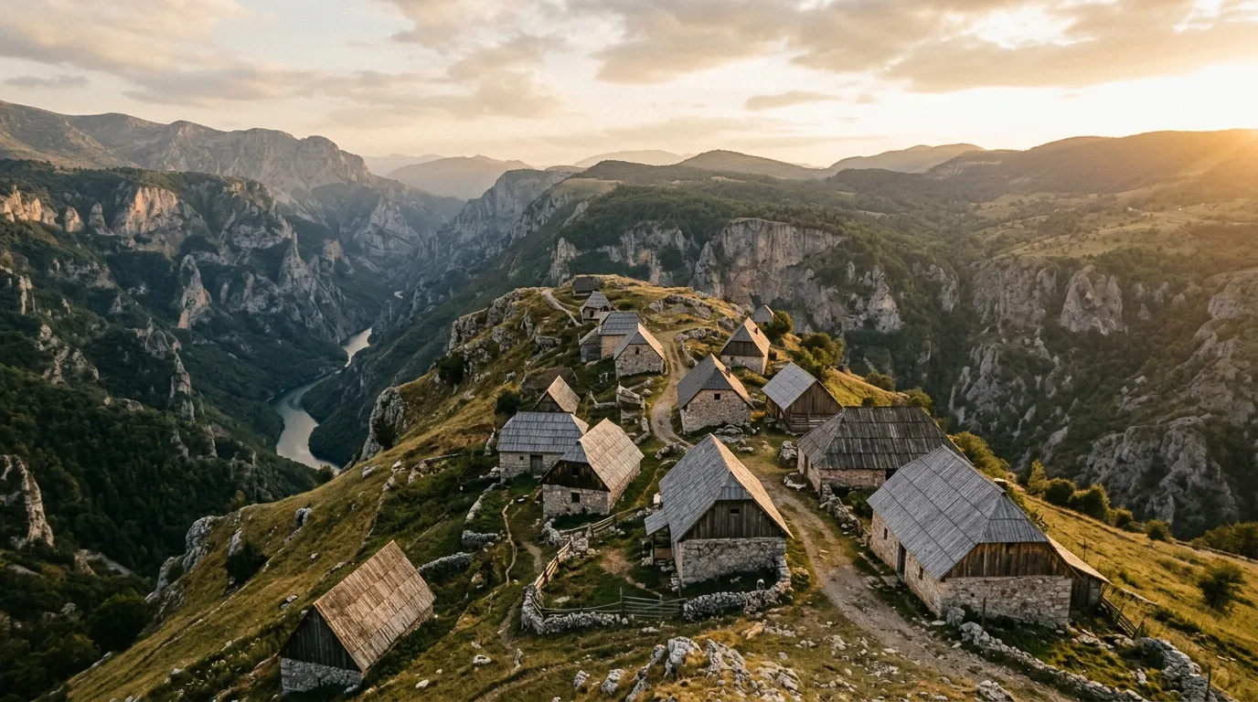
Bosnia Off-Road Routes
Bosnia and Herzegovina is the Balkan country that the travel industry has not yet figured out how to sell. Croatia has the coast. Montenegro has Kotor and Durmitor. Albania has the “hidden gem” narrative. Bosnia has — what? Sarajevo, Mostar, war history, and then a blank space in most people’s itineraries where the country’s actual geography should be.
That blank space is where we drive. The Dinaric Alps run the length of Bosnia’s western and central highlands, creating a mountain spine of limestone, forest, and highland meadow that is geologically continuous with Montenegro and Croatia but touristically invisible. The roads exist because villages exist, and the villages exist because shepherds have grazed these mountains for centuries, and nobody has yet decided to market this as adventure tourism. The result is off-road driving in the center of Europe with traffic levels that most countries reserve for their most remote corners.
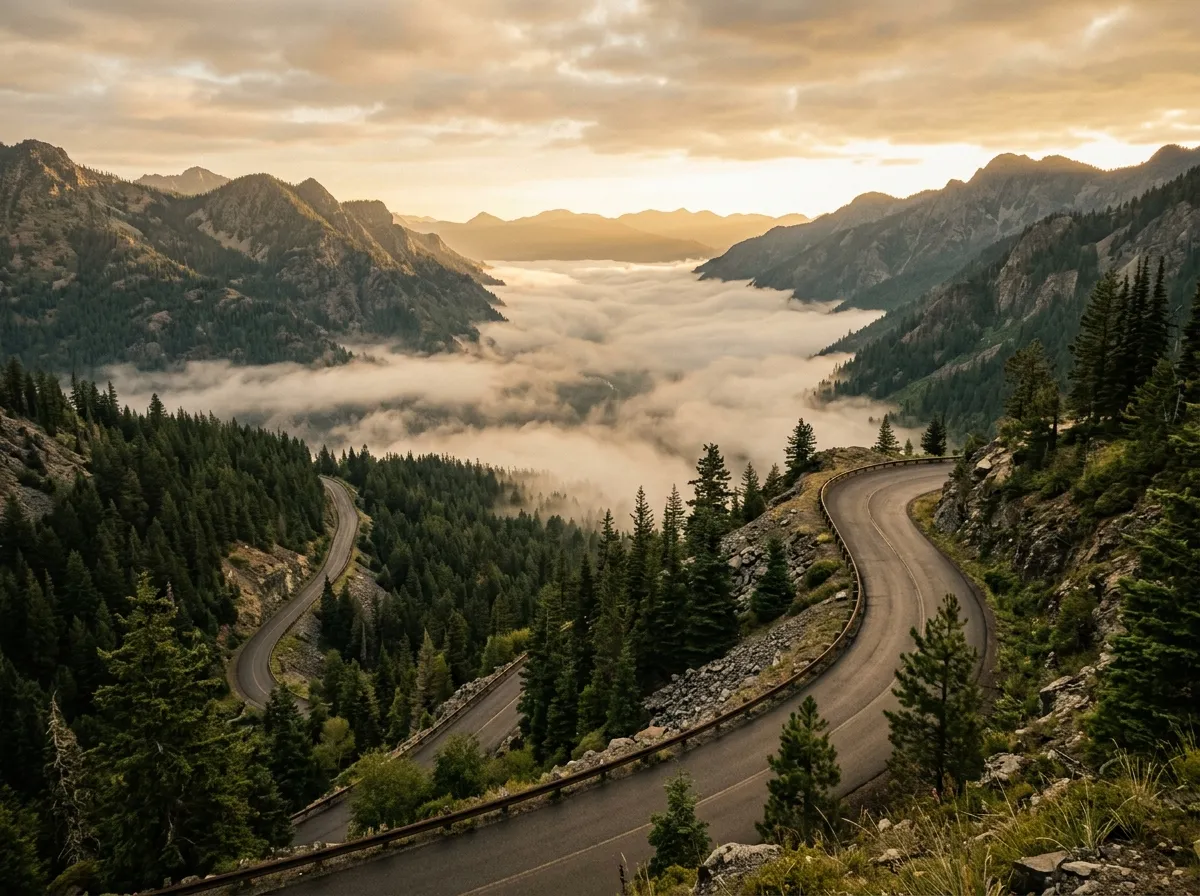
We drove three routes across the Bosnian highlands: the Via Dinarica access tracks along the backbone of the Dinaric Alps, the Lukomir Highland Road to Bosnia’s highest and most isolated village, and the Sutjeska National Park trails through primeval forest and along the Tara River canyon. Between them, they cover the range of Bosnian off-road terrain — from maintained gravel roads with mountain views to rocky tracks above the treeline to wet forest paths through trees that were old when the Ottoman Empire was young.
Terrain classification
Bosnia’s off-road terrain is defined by two geological features: the Dinaric limestone that creates the highland plateaus and ridgelines, and the rivers that have cut deep valleys between them. The tracks follow both — climbing to the ridges for views and pasture access, then descending into the valleys for village connections and river crossings.
| Terrain type | Where you find it | Vehicle requirement |
|---|---|---|
| Highland meadow track | Bjelasnica, Treskavica, Via Dinarica corridor | 4x4 recommended |
| Mountain gravel road | Main highland connections | High-clearance 2WD |
| Forest track | Sutjeska, Prenj, Igman | 4x4 for muddy sections |
| River valley road | Neretva approaches, Tara canyon | High-clearance 2WD |
| Rocky alpine track | Above treeline on Bjelasnica, Prenj | 4x4 required |
The Bosnian highlands are wetter than their Albanian or Montenegrin counterparts. More rainfall means more forest, more mud, and greener landscapes. It also means the tracks deteriorate faster — a gravel road that is fine in July can be rutted and soft by October. Season matters more here than in drier Balkan countries.
Our documented routes
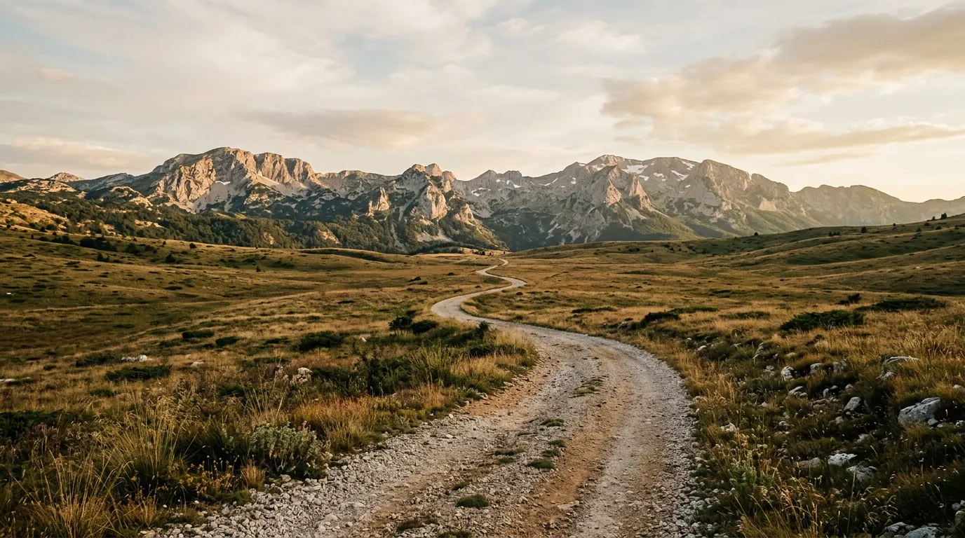
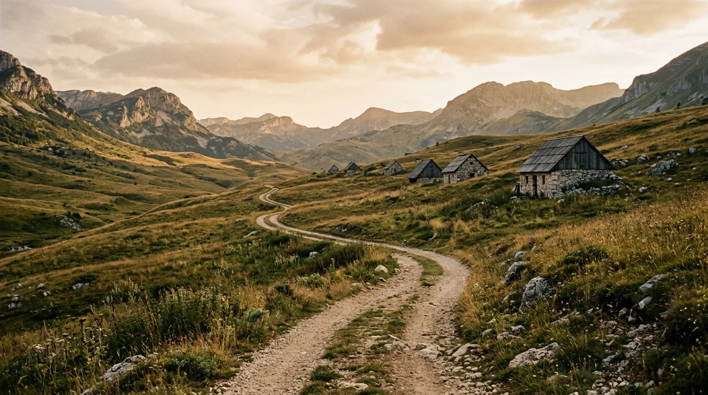
Via Dinarica Access Tracks
| **Catalog: TB-BA-001 | Difficulty: Moderate | Distance: 150 km | Duration: 2 days** |
The Via Dinarica is a long-distance hiking trail that follows the Dinaric Alps from Slovenia to Albania. The access roads that serve this trail — connecting trailheads, mountain huts, and highland villages — form a driveable corridor through some of Bosnia’s most dramatic mountain terrain. We drove a 150 km section of these access tracks through the central Bosnian highlands, linking mountain passes, highland meadows, and villages where the stone houses predate living memory. Read the full route guide.
Lukomir Highland Road
| **Catalog: TB-BA-002 | Difficulty: Moderate | Distance: 35 km | Duration: Half day** |
Lukomir is Bosnia’s highest permanently inhabited village, sitting at 1,495 metres on the southern rim of the Bjelasnica mountain. The road from Sarajevo to Lukomir climbs through pasture and exposed highland to a medieval stone settlement that is snowbound for six months of the year. The drive is short — 35 km of unpaved road from the last paved junction — but the destination is extraordinary: a stone village on the edge of a canyon, occupied by a handful of families who live as the highland Bosnians have lived for centuries. Read the full route guide.
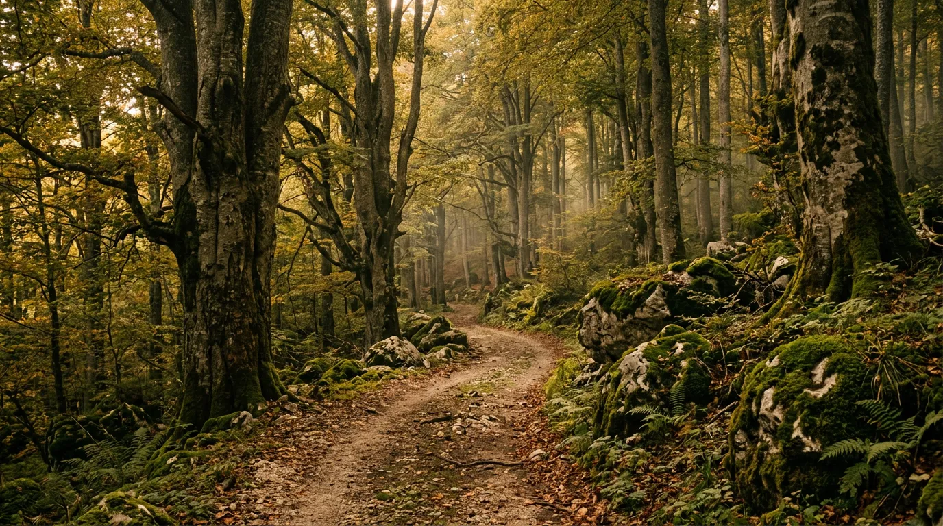
Sutjeska National Park Trails
| **Catalog: TB-BA-003 | Difficulty: Moderate | Distance: 70 km | Duration: 1 day** |
Bosnia’s oldest national park contains the Perucica primeval forest — one of the last remnants of old-growth forest in Europe — and a network of forest tracks along the Tara River canyon. The driving is moderate in difficulty but the forest environment is unmatched in the Balkans: massive beech and fir trees, moss-covered boulders, streams crossing the track at regular intervals, and a persistent green dampness that makes the air feel thick. Read the full route guide.
Practical information
Vehicle selection
Bosnia is a Dacia Duster country. The Duster 4x4 handles all three of our routes in dry conditions and most sections in wet conditions. The 2WD Duster manages the Via Dinarica access tracks and parts of the Lukomir road in summer, but will struggle on muddy highland sections and the steeper forest tracks in Sutjeska.
Rental agencies in Sarajevo offer the best selection. The major international chains are present, but local agencies — particularly those familiar with Bosnian road conditions — are often more helpful about which vehicle categories are available and what the insurance actually covers. Ask specifically about off-road coverage: Bosnian rental contracts vary widely on this point.
The Suzuki Jimny is available in Sarajevo but less common than in Albania or Montenegro. It is more vehicle than you need for most Bosnian routes, though the peace of mind of low-range is worth the cramped quarters if you are driving in marginal weather.
Fuel planning
Bosnia’s fuel network is adequate along the main road corridors but thin in the highlands. Sarajevo, Mostar, Konjic, and Foca are the relevant fuel towns for our routes.
| Route | Last reliable fuel | Next fuel | Gap |
|---|---|---|---|
| Via Dinarica tracks | Konjic or Prozor | Variable (depends on section) | ~60-80 km |
| Lukomir | Sarajevo suburbs or Hadzici | Sarajevo (return) | ~70 km round trip |
| Sutjeska | Foca or Tjentiste | Foca (return) | ~70 km |
Carry a 10L jerry can for any route. The fuel gaps are not extreme, but the mountain driving burns fuel faster than the distance implies, and the margin of error is thinner than in Romania or Montenegro.
Season and weather
May through October is the driving season. The core season is June through September for highland routes — Lukomir and the higher Via Dinarica sections are snow-free during this window. Sutjeska’s forest tracks at lower elevation are accessible from May.
Bosnia receives more rainfall than the rest of the Balkans, particularly in the highlands. Average precipitation in the mountains is 1,500-2,000 mm per year, which is significant. Rain can fall on any day in any month of the driving season. The practical implication: carry rain gear, expect mud, and accept that the scenic highland drive you planned may become a slippery highland crawl if the weather turns.
Landmine awareness
This requires mentioning. Bosnia’s 1992-1995 war left minefields, most of which have been cleared but some of which remain. Marked minefields are indicated by red signs with skull-and-crossbones or the text “MINE.” All of our routes follow established tracks that are in regular use and are considered safe. The rule is simple: stay on the track. Do not walk into unmarked undergrowth off the established paths, particularly near former front lines (the ridge above Sarajevo, areas around Mostar, rural areas near Brcko). This is not a reason to avoid Bosnia. It is a reason to stay on the road, which is what we came to drive on anyway.
Field notes
Sarajevo is the natural base for Bosnian off-road driving. The city sits in a valley at 500 metres, surrounded by mountains — Bjelasnica, Igman, Trebevic, Jahorina — that are accessible within 30-45 minutes of driving. Lukomir is a half-day trip from central Sarajevo. The Via Dinarica sections we cover are 2-3 hours from the city. Sutjeska is the furthest, at approximately 3 hours southeast.
Bosnian hospitality is direct and generous. We received coffee, directions, and a detailed assessment of our vehicle’s suitability for the road ahead from people we had not asked. The highland villages, in particular, treat visitors with a warmth that reflects genuine curiosity — not many tourists drive to Lukomir, and the ones who do are worth talking to.
Food in the highlands is simple and excellent. Burek (layered pastry with meat or cheese), cevapi (grilled minced meat), and kajmak (clotted cream) are available in any town. Mountain villages offer lamb and local cheese. Bosnian coffee is strong, thick, and served in a dzezva with a sugar cube on the side. Accept every offer.
Mobile coverage is good in Sarajevo and along the main corridors. In the highlands, coverage drops to intermittent. On the Via Dinarica tracks and in parts of Sutjeska, coverage is absent. Download offline maps (OsmAnd) before departing Sarajevo.
Related regions
Bosnia shares the Dinaric Alps with Montenegro, where the terrain is similar but the infrastructure is slightly more developed. The Prokletije and Sinjajevina routes in Montenegro are harder than anything in Bosnia, but Bosnia’s Via Dinarica tracks are longer and more varied. Albania extends the Dinaric geological zone southward with more extreme altitude and less forest cover. Romania offers a different mountain experience — the Carpathians are geologically distinct from the Dinarics, with different rock, different forest, and considerably more bears.
Ground clearance, tire type, and 4x4 lock differ between agencies. Compare before you book.