Georgia
Route Specimens
3 routes surveyed
Georgia Off-Road Routes
Georgia is the country where we stopped pretending that travel was about museums and restaurants. We had rented a Suzuki Jimny from a man in Tbilisi who shrugged when we mentioned Tusheti, said something in Georgian that our driver friend translated as “it’s open, probably,” and handed us the keys with the casual indifference of someone who either trusted the vehicle completely or did not care what happened to it. Three days later we returned the Jimny with a cracked skid plate, half the original tread depth on the rear tires, and a conviction that Georgia contains some of the finest unpaved driving on the European continent.
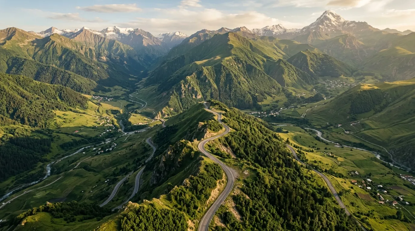
The Greater Caucasus mountains form a wall across Georgia’s northern border — a barrier of peaks above 4,000 metres that has kept the highland valleys isolated for centuries. The roads that cross these mountains were built for military and agricultural access, not tourism. They are narrow, steep, unguarded, and spectacularly maintained in the way that a track is maintained when the alternative is a village being cut off from the rest of the country for five months of winter. These are working roads. That they happen to traverse some of the most dramatic landscapes in the Northern Hemisphere is incidental.
We have driven three routes across Georgia’s off-road terrain: the Tusheti Road over Abano Pass, the Jvari Pass to Mestia highland route through Svaneti, and the David Gareja desert loop in the semi-arid southeast. Between them, they cover an elevation range of 2,500 metres, four distinct terrain types, and the full spectrum from expert-level cliff-edge switchbacks to an easy half-day gravel drive suitable for a rented hatchback with reasonable ground clearance.
Terrain classification
Georgia’s geology is the product of two continental plates arguing with each other for several million years. The Caucasus is a collision zone, and it shows — the terrain changes faster here than anywhere else we have driven in Europe. You can start a morning in subtropical lowland, cross a 2,900-metre pass by midday, and end up in semi-desert by evening, all within a country smaller than Ireland.
| Terrain type | Where you find it | Vehicle requirement |
|---|---|---|
| Mountain switchbacks | Tusheti road, Jvari Pass, Upper Svaneti | 4x4 with low-range essential |
| Highland gravel | Svaneti approach roads, Kazbegi area | 4x4 recommended, high-clearance 2WD possible |
| River crossing | Tusheti, Svaneti, multiple valley routes | 4x4 with adequate clearance |
| Semi-desert steppe | David Gareja, Vashlovani | High-clearance 2WD sufficient |
| Forest track | Borjomi-Bakuriani, Lagodekhi | High-clearance 2WD |
The mountain routes are genuinely demanding. The Tusheti road has killed people — not as a scare statistic, but as a factual statement about what happens when you combine single-lane dirt tracks, 500-metre drops, no guardrails, and oncoming traffic that expects you to reverse. The lowland routes, by contrast, are among the most rewarding easy drives we know. The David Gareja loop offers monastery caves carved into desert cliffs, Azerbaijan border views, and painted frescoes from the sixth century, all accessible in a Dacia Duster.
Our documented routes
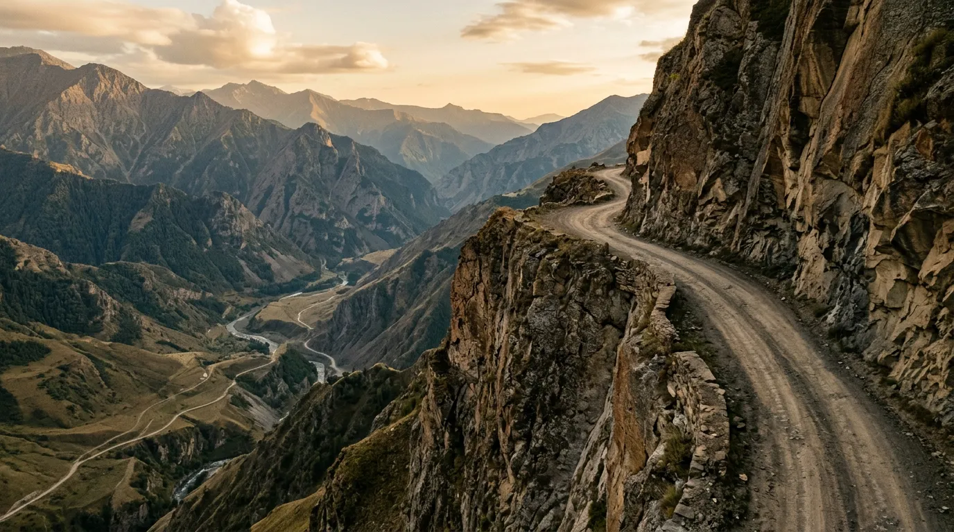
Tusheti Road
| **Catalog: TB-GE-001 | Difficulty: Expert | Distance: 72 km | Duration: 1 day (one way)** |
The headline route. The road to Tusheti via Abano Pass is frequently cited as one of the most dangerous roads in the world, and for once the hyperbole is roughly calibrated. Seventy-two kilometres of unguarded cliff-edge switchbacks climbing to 2,926 metres — the highest drivable pass in the Caucasus — with blind corners, oncoming trucks, and waterfall-fed mud sections that redefine “road surface” as a generous category. The reward is Omalo: a highland village of medieval defensive towers sitting in a valley so remote that it had no year-round road access until surprisingly recently. You will need a 4x4 with low-range, a full tank, recovery gear, and a tolerance for exposure. We have driven it twice and would drive it again tomorrow. Read the full route guide.
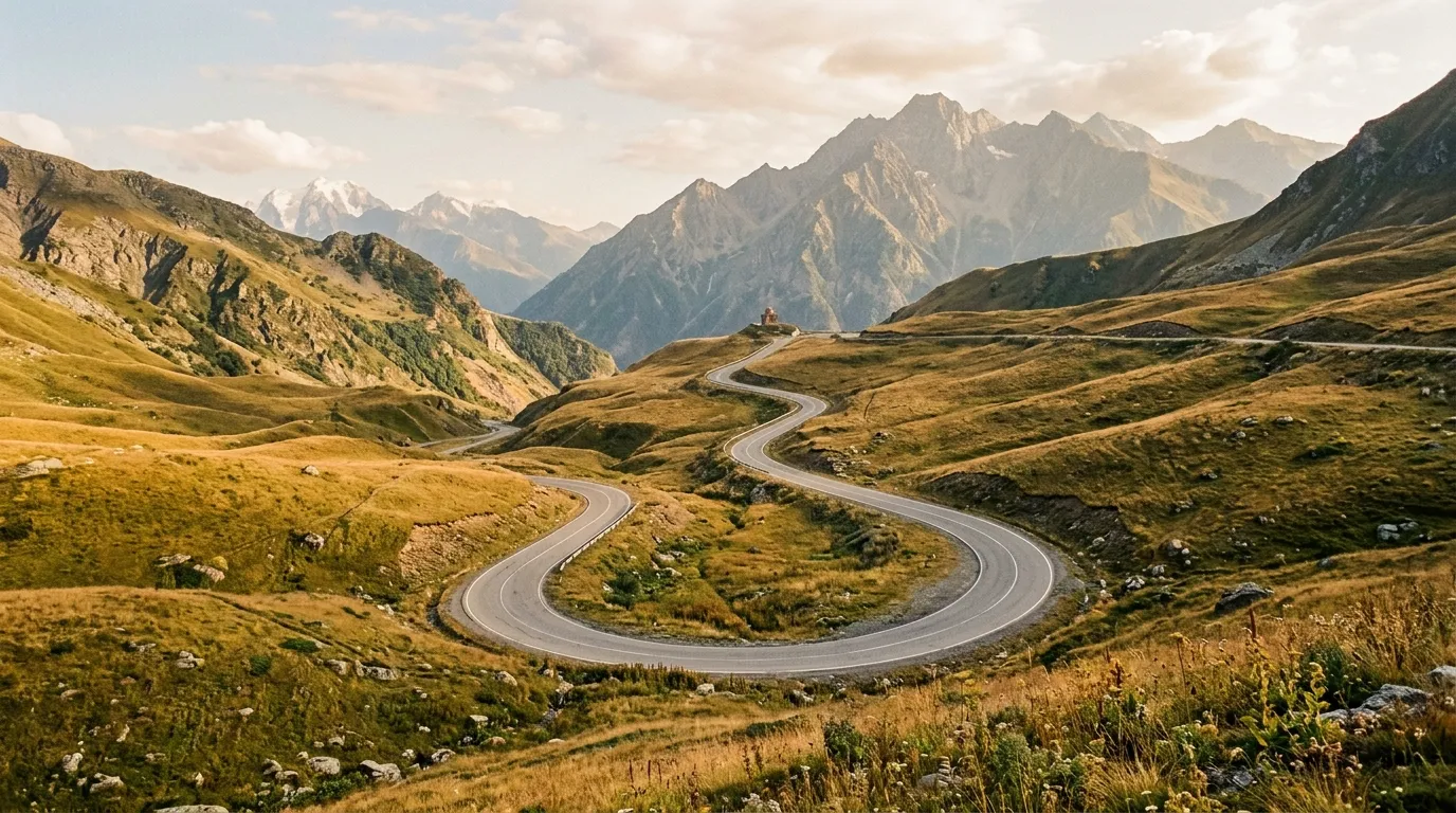
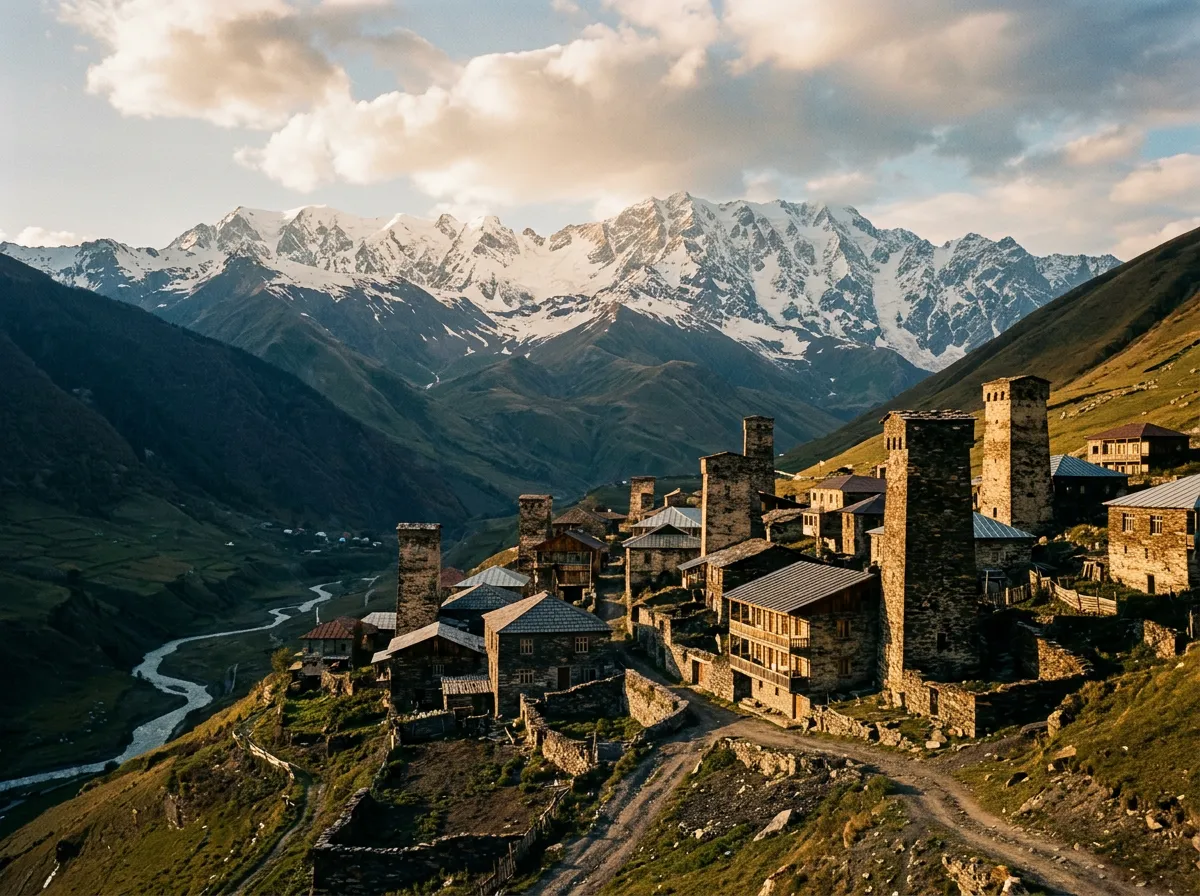
Jvari Pass to Mestia
| **Catalog: TB-GE-002 | Difficulty: Moderate | Distance: 140 km | Duration: 1-2 days** |
The route into Upper Svaneti crosses Jvari Pass at 2,379 metres before descending into the Enguri valley and climbing again to Mestia, the regional capital. The old road over the pass is being supplemented by a new tunnel, which is more efficient and entirely misses the point. The pass itself offers views of the western Caucasus ridge that are worth the gravel and the switchbacks. Mestia is the base for reaching Ushguli — Europe’s highest continuously inhabited settlement — where the Svan defensive towers stand against a backdrop of glacier and sky. The road is moderate by Georgian standards, which means it would be considered rough by anyone else’s. Read the full route guide.
David Gareja Desert Loop
| **Catalog: TB-GE-003 | Difficulty: Easy | Distance: 100 km | Duration: Half day** |
The accessible route. A half-day loop from Tbilisi through Georgia’s semi-desert steppe to the David Gareja monastery complex — a sixth-century cave monastery carved into a cliff face on the Azerbaijan border, decorated with frescoes that have survived 1,400 years of weather, neglect, and border disputes. The drive is gravel and dirt, flat to rolling, with no river crossings and no cliff edges. A high-clearance 2WD handles it without complaint. The monastery and the steppe landscape are the draw here, not the driving difficulty. This is the route we recommend to people who want to understand why Georgia is on our list but are not ready for Abano Pass. Read the full route guide.
Practical information
Vehicle selection
Georgia’s rental market has improved significantly. In Tbilisi you can find Suzuki Jimnys, Mitsubishi Pajeros, and Toyota Prados from established agencies. The Jimny is the local workhorse for mountain roads — narrow enough for the single-lane tracks, low-range capable, and cheap enough that the rental agency will not have a nervous breakdown when you mention Tusheti. For the David Gareja loop, any crossover with reasonable ground clearance will do. We have seen people do it in a Hyundai Tucson. They looked stressed but they made it.
Fuel planning
Georgia’s fuel network is reliable in the lowlands and non-existent in the mountains. The critical gaps are on the Tusheti road (no fuel at all in Tusheti — fill up in Alvani) and on the Svaneti route (limited fuel between Zugdidi and Mestia). Carry a jerry can for any mountain route.
| Route | Last reliable fuel | Next fuel | Gap |
|---|---|---|---|
| Tusheti Road | Alvani | Alvani (return) | ~150 km round trip |
| Jvari to Mestia | Zugdidi | Mestia | ~140 km |
| David Gareja | Sagarejo | Sagarejo (return) | ~120 km round trip |
Season and weather
The mountain routes are seasonal. Abano Pass typically opens in mid-to-late June and closes with the first heavy snow in October — sometimes September. Jvari Pass has similar constraints, though the new tunnel provides year-round access to Mestia for those willing to skip the pass. David Gareja can be driven year-round, but summer temperatures in the steppe exceed 40 degrees Celsius and make the approach walk to the monastery genuinely unpleasant. The optimal window for David Gareja is April to June and September to November.
The sweet spot for all three routes is July to September: passes open, weather stable, daylight long enough for the mountain routes.
Permits and access
Georgia is refreshingly relaxed about permits. There are no off-road driving fees, no park entry charges for the routes we document, and no requirement for guides or escorts. The Tusheti road passes through a border zone (the region borders Russia), and while a permit is technically not required for the road itself, carrying your passport and having accommodation details available is sensible. Checkpoint stops are rare but possible.
Field notes
Georgian hospitality is real and occasionally overwhelming. We stopped in a village on the Tusheti road to check tire pressure and were invited into a house for wine, cheese, bread, and a conversation conducted entirely in gestures and goodwill. This added two hours to our schedule and remains one of the better unplanned stops of any trip we have taken.
The road infrastructure is improving year on year. New tunnels, paved sections, and bridges are being built across Svaneti and other mountain regions. This is good for the villages that depend on access and less good for the adventure driver seeking isolation. Drive the old passes while they are still the main route — some of them will become scenic alternatives within a few years.
Mobile coverage is patchy to strong in the lowlands (Magti and Geocell both have decent networks) and nonexistent above 2,000 metres. Download offline maps — Maps.me has good coverage of Georgian mountain tracks.
Georgian wine is excellent, inexpensive, and available everywhere including the most remote mountain villages. This is relevant to your evening planning, not your driving planning.
Related regions
If Georgia’s combination of mountain passes and highland isolation appeals to you, consider Albania for similarly dramatic terrain with less traffic and even fewer guardrails. Iceland offers the highland track experience in a volcanic context — different geology, same spirit of committed remote driving. Romania has the Carpathian passes and forest tracks that serve as a gentler entry point to European mountain driving.
Ground clearance, tire type, and 4x4 lock differ between agencies. Compare before you book.