Namibia
Route Specimens
3 routes surveyed
Namibia Off-Road Routes
Namibia is the country that taught us what distance means. Not distance as a number on a map — we understood that before arriving — but distance as a physical, psychological experience. The kind of distance where you drive for three hours on a gravel road that is straight enough to see the vanishing point and encounter no other vehicle, no structure, no evidence of human activity of any kind. The kind of distance where the fuel gauge becomes the most important instrument in the vehicle, and the mental arithmetic of litres remaining versus kilometres to the next pump station becomes a background process that runs continuously, like breathing.
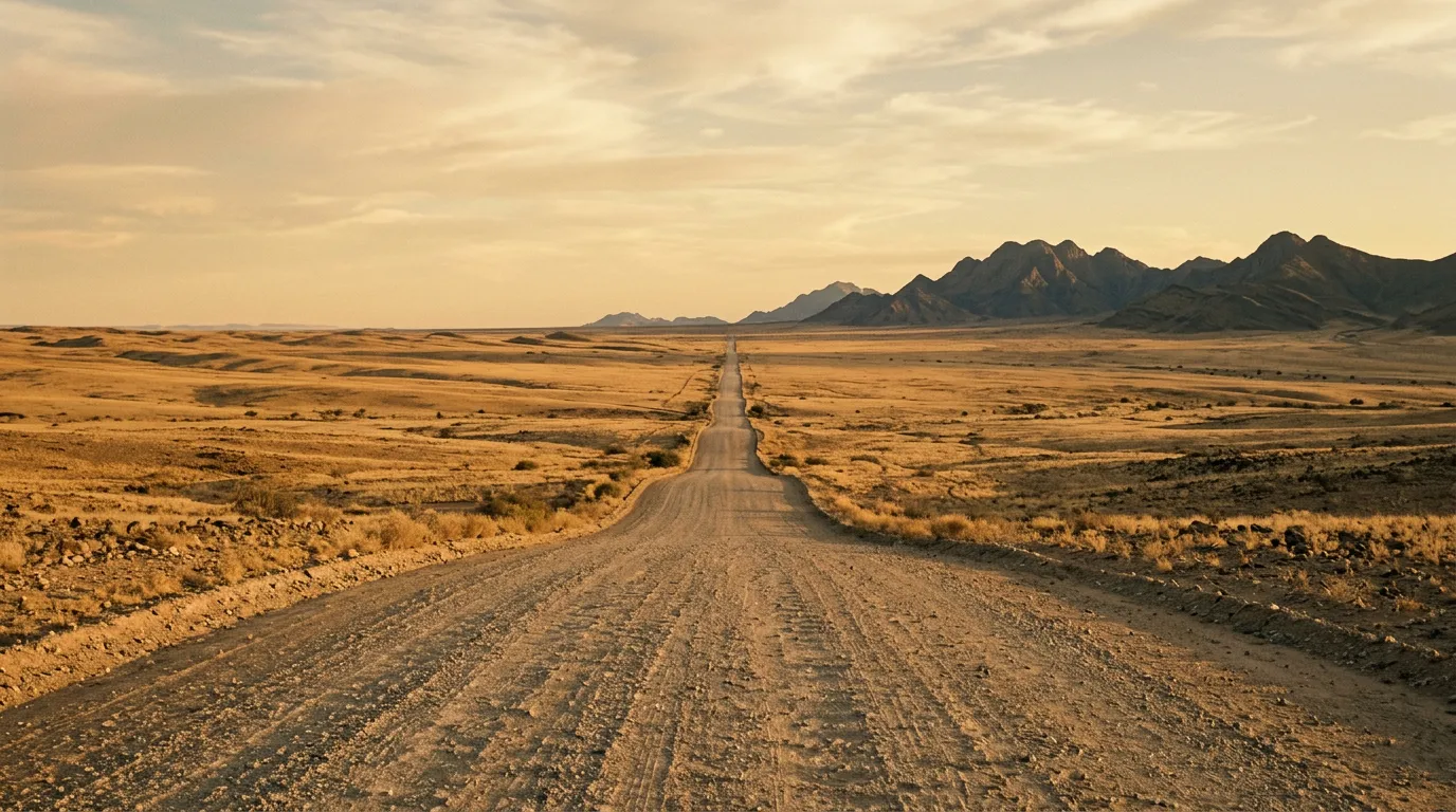
Namibia has approximately 5,400 km of tarred road and 37,000 km of gravel road. The ratio is informative. This is a country designed — if a country can be said to be designed — for self-drive travel on unpaved surfaces, and its gravel highways are among the best-maintained in Africa. But the gravel highways are not the interesting bits. The interesting bits are the tracks that branch off them: sand roads into the Namib Desert, dry riverbeds through Damaraland, fog-shrouded coastal routes along the Skeleton Coast, and the final kilometres to places like Deadvlei and Sossusvlei that no amount of photography can prepare you for.
We have driven three routes across Namibia: the fog and shipwrecks of the Skeleton Coast, the elephant-tracking tracks of Damaraland, and the gravel approaches to Sossusvlei. Between them, they cover the Namib Desert from coast to dune field, and they demonstrate why Namibia is the self-drive capital of Africa — not because the driving is the hardest (it is not; Ethiopia and Tanzania are harder) but because the infrastructure supports independent travel through landscapes that would be inaccessible in most other countries on the continent.
Terrain classification
Namibia’s terrain is dominated by desert. The Namib — one of the oldest deserts on Earth, approximately 55 million years old — runs the entire length of the country’s Atlantic coast, from the Orange River in the south to the Kunene River in the north. Inland, the terrain rises through semi-arid savanna to the central highlands around Windhoek, then descends again to the Kalahari semi-desert in the east. For the off-road driver, this translates to a spectrum of surface types, each with its own vehicle demands.
| Terrain type | Where you find it | Vehicle requirement |
|---|---|---|
| Gravel highway | B and C roads nationwide | 2WD sufficient, speed limit 80-120 km/h |
| Salt road | Skeleton Coast C34 | 2WD sufficient, corrugation warning |
| Desert sand track | Damaraland, Skeleton Coast interior | 4x4 with low-range |
| Dry riverbed | Damaraland, Kaokoveld | 4x4 with low-range, experience required |
| Dune approach | Sossusvlei, Sandwich Harbour | 4x4, deflated tires |
| Rocky mountain track | Damaraland, Brandberg | 4x4 with high clearance |
The gravel highways deserve special mention. Namibia’s C-roads (secondary highways, all gravel) are graded regularly and in good conditions feel like driving on a well-maintained dirt road at 80 km/h. The temptation is to drive them at 100 or 110 km/h, which the surface occasionally permits and the emptiness encourages. Resist this. Corrugation — a washboard pattern in the gravel surface — builds at higher speeds and creates a vibration that loosens every bolt on your vehicle. Tire blowouts on corrugated gravel at speed are the most common cause of vehicle damage in Namibia. We saw three blown tires on the roadside during a single day on the C14. Drive at 80 km/h, check your tire pressures at every stop, and carry two spare tires.
Our documented routes
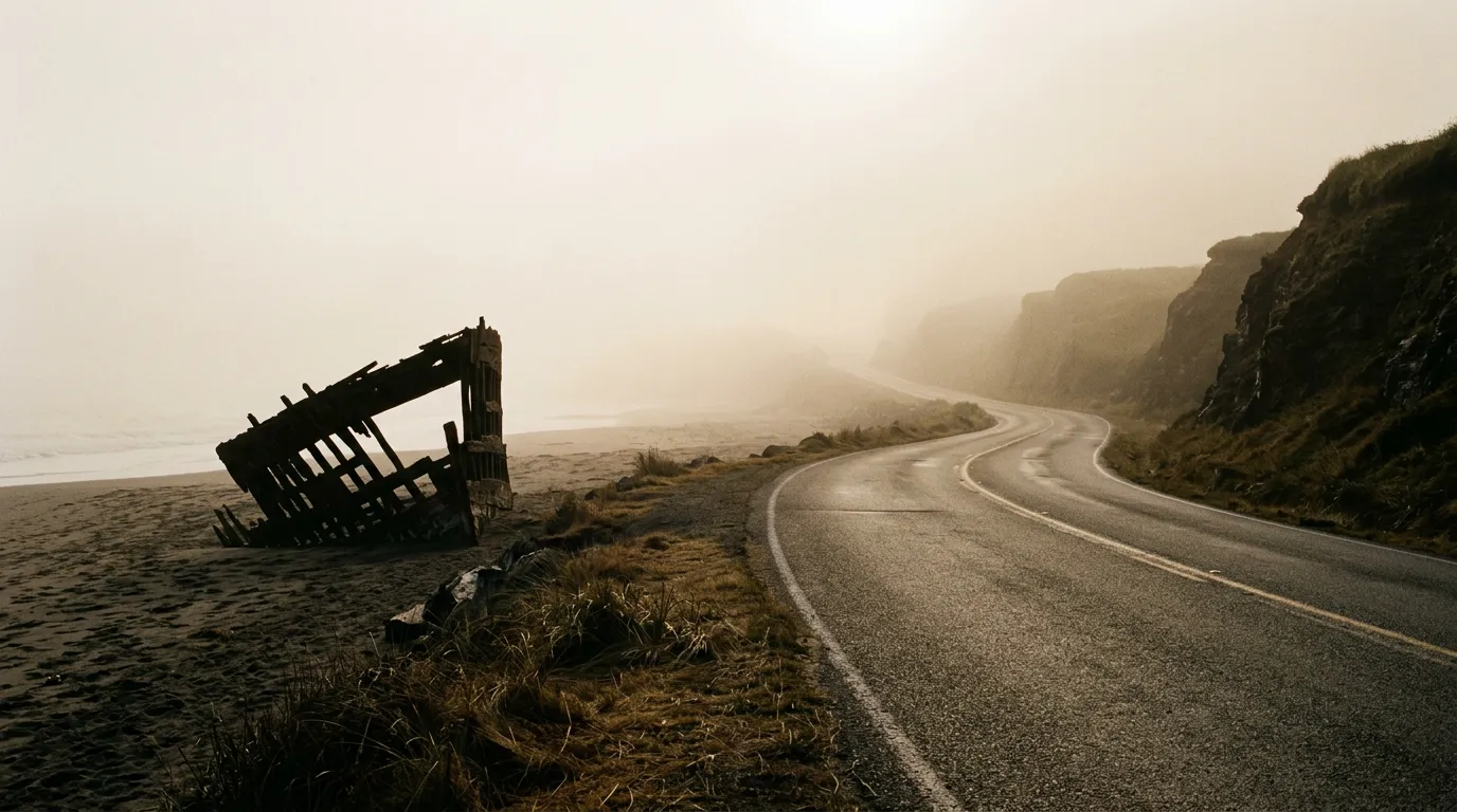
Skeleton Coast Route
| **Catalog: TB-NA-001 | Difficulty: Moderate | Distance: 250 km | Duration: 2-3 days** |
The Skeleton Coast is where the Namib Desert meets the Atlantic Ocean, and neither has much interest in human presence. The C34 highway runs 250 km along the coast from Henties Bay to Terrace Bay through fog, past shipwrecks half-buried in sand, and alongside a Cape Cross seal colony that numbers over 100,000 animals and smells exactly as you would expect 100,000 seals to smell. The road itself is a salt surface — hard, fast, and monotonous — but the landscape is anything but. The fog that rolls in from the cold Benguela Current creates visibility conditions that shift from 50 metres to 50 kilometres within minutes, and the shipwrecks that give the coast its name are visible from the road as dark shapes emerging from sand dunes. No services between Henties Bay and Terrace Bay. Carry everything. Read the full route guide.
Damaraland Elephant Tracks
| **Catalog: TB-NA-002 | Difficulty: Challenging | Distance: 120 km | Duration: 2 days** |
Damaraland is where Namibia gets difficult. The tracks are unmarked, the terrain alternates between soft sand riverbeds and rocky plains, and the destination — desert-adapted elephants moving through dry riverbeds — requires finding animals that do not follow schedules in a landscape that has no roads. We hired a local tracker from the community conservancy, which is both the ethical and practical approach, and spent two days following fresh tracks through the Huab and Aba-Huab riverbeds. We found the elephants on the second morning. The driving was the hardest we have done in Namibia. The Twyfelfontein rock engravings — 6,000-year-old petroglyphs on a hillside — provided a counterpoint that reminded us the difficulty of this terrain has been understood for millennia. Read the full route guide.
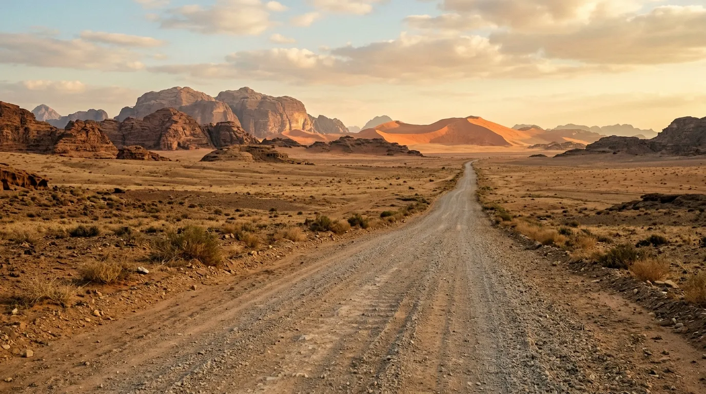
Sossusvlei Gravel Approaches
| **Catalog: TB-NA-003 | Difficulty: Easy | Distance: 350 km | Duration: 1-2 days** |
The routes to Sossusvlei are, for most of their length, straightforward gravel highway driving. The C14 from Walvis Bay runs 200 km through the Namib-Naukluft Park on a surface that is fast and empty and framed by scenery that qualifies as monotonous until the light changes, at which point it becomes extraordinary. The interest — and the challenge — arrives in the final 5 km to Deadvlei, where the tarred park road ends and a soft sand track begins, requiring deflated tires and a 4x4. But the real value of this route is the approach itself: 350 km of desert driving that demonstrates why Namibia’s gravel highways are among the best driving experiences in Africa. Read the full route guide.
Practical information
Vehicle selection
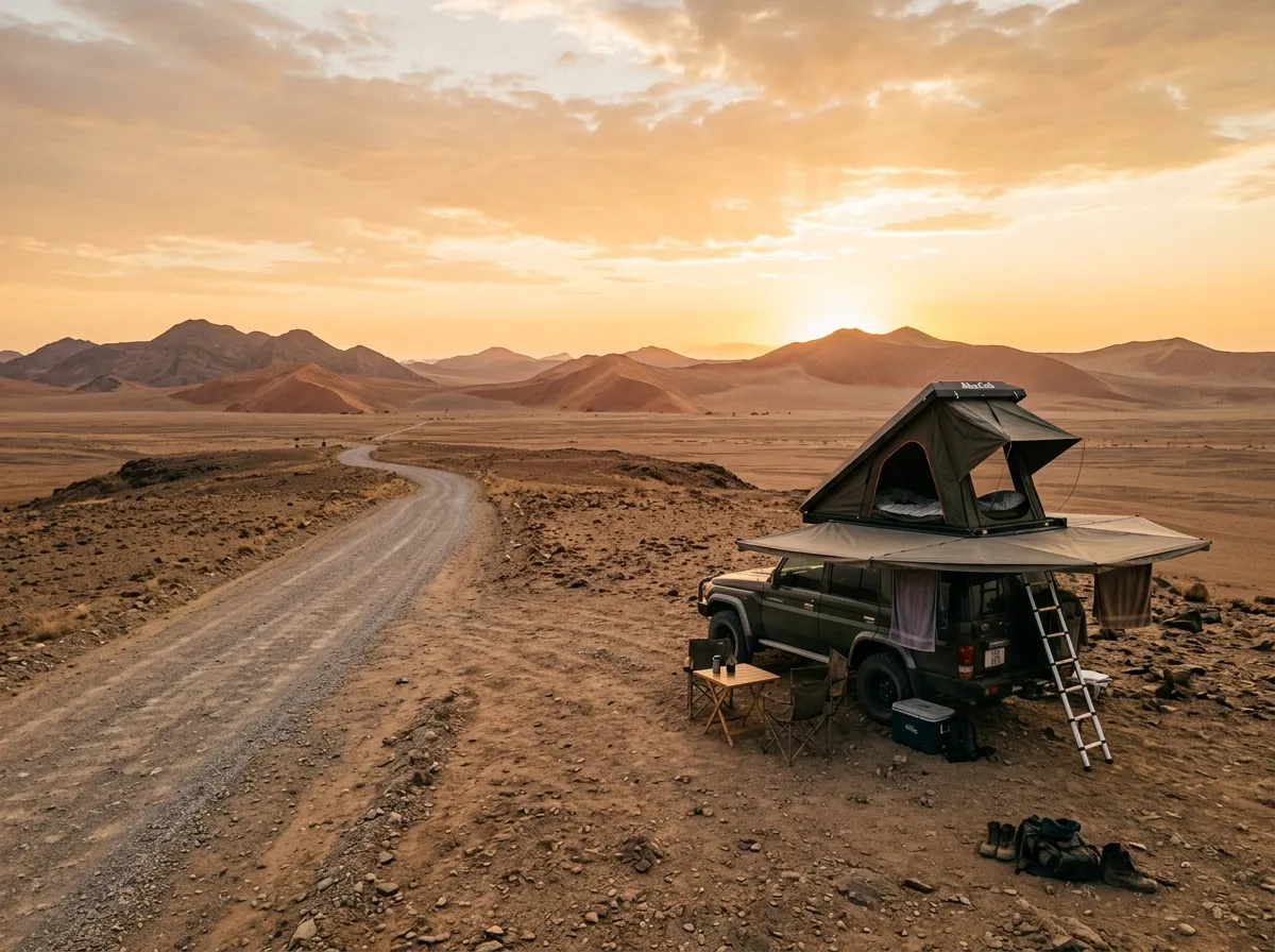
Namibia’s self-drive rental market is the most developed in sub-Saharan Africa. Agencies in Windhoek offer everything from compact sedans (for tarred-road-only tourists, of whom there are many) to fully equipped 4x4 campers with roof tents, fridges, recovery gear, and dual spare wheels. For our routes, the minimum is a 4x4 with high clearance — the Damaraland riverbeds and the Sossusvlei sand track both require it. For the Skeleton Coast C34 alone, a 2WD with good tires would suffice, but you would not want to be limited to the main road.
The standard rental 4x4 in Namibia is the Toyota Hilux with a rooftop tent. This is a vehicle that has been optimized by the Namibian rental industry for the country’s specific demands: ground clearance, long fuel range, space for camping equipment, and dual spare tires. We rented one from a Windhoek agency and found it competent on every surface we encountered. The rooftop tent is an acquired taste — the setup takes 10 minutes, the sleeping is comfortable, and the dismantling in the morning before coffee has been consumed is one of life’s minor ordeals.
Fuel planning
Fuel in Namibia is reliable in towns and nonexistent between them. The distances between fuel stops are the single most important planning variable for any self-drive trip.
| Route | Last reliable fuel | Next fuel | Gap |
|---|---|---|---|
| Skeleton Coast (Henties Bay to Terrace Bay) | Henties Bay | Terrace Bay | 250 km |
| Damaraland (Khorixas to Palmwag) | Khorixas | Palmwag | 120 km |
| Sossusvlei (Walvis Bay to Sesriem) | Walvis Bay or Solitaire | Sesriem | 200 km |
Carry a minimum 20L jerry can for any route that includes a fuel gap over 150 km. Fill your tank at every opportunity, even if it is three-quarters full. This is the universal advice from every Namibia self-drive guide, and it is universal because every Namibia self-drive guide was written by someone who once had to think carefully about fuel at a time when thinking carefully was not comfortable.
Season and weather
Namibia is driveable year-round, but the optimal season is May to October (dry season, southern hemisphere winter). Summer (November to March) brings extreme heat in the interior — daytime temperatures above 40 degrees Celsius — and occasional rain in the north that can make riverbeds impassable. The Skeleton Coast fog is most intense from November to February, which reduces coastal visibility but also reduces coastal temperatures to comfortable levels.
Winter nights in the Namib are cold: 5-10 degrees Celsius in the desert, occasionally below zero at altitude. The diurnal temperature range — the difference between the daytime high and the nighttime low — can exceed 30 degrees. Pack for both extremes.
Permits and access
Most of Namibia’s off-road routes require no permits. The exceptions:
- Skeleton Coast (north of Terrace Bay): limited access permits through Namibia Wildlife Resorts (NWR). These must be booked in advance and are limited in number.
- Etosha National Park: entry permits and campsite bookings through NWR.
- Community conservancies (Damaraland): no formal permit, but a community levy is expected and a local guide is recommended.
- Namib-Naukluft Park (Sossusvlei): entry fee at the Sesriem gate, payable on arrival.
Field notes
Namibia is a country that rewards self-sufficiency. The infrastructure supports independent travel — fuel, campsites, rental agencies — but the distances between these support points are large enough that you must be capable of managing problems alone. A flat tire at 14:00 on the C14, 80 km from the nearest town, is not a crisis if you have two spares and know how to change a wheel. It is a crisis if you do not.
The Namibian driving culture is notably polite. On gravel roads, oncoming vehicles slow down and move to the edge to reduce the stone-throw risk. Faster vehicles approaching from behind will wait for you to pull over rather than overtaking on blind gravel. Hand-waving from passing vehicles is customary and genuine. This is a country where every driver on a gravel road understands what every other driver on that gravel road is dealing with, and the mutual respect is tangible.
Mobile coverage exists in towns and along major tarred highways. It does not exist on the routes we describe. Download offline maps (Maps.me has excellent Namibia coverage, including most gravel tracks). Carry a satellite communicator if you are venturing into Damaraland or the northern Skeleton Coast. Cell signal in the Namib Desert is not something you should plan around.
Water: carry 5 litres per person per day for any route beyond the main highways. The desert is explicit about this requirement.
Related regions
Namibia connects naturally to South Africa via the Sendelingsdrif border crossing in the Richtersveld — the landscapes are geologically continuous, and a trip combining the Richtersveld with the southern Namibian desert makes geographic and logistical sense. For similar desert driving in a different cultural context, Morocco offers Sahara piste crossings and Atlas mountain passes. And for desert-plus-mountain driving with a Middle Eastern flavour, Oman shares Namibia’s combination of vast gravel distances and dramatic geological formations.
Ground clearance, tire type, and 4x4 lock differ between agencies. Compare before you book.