
Lukomir Highland Road
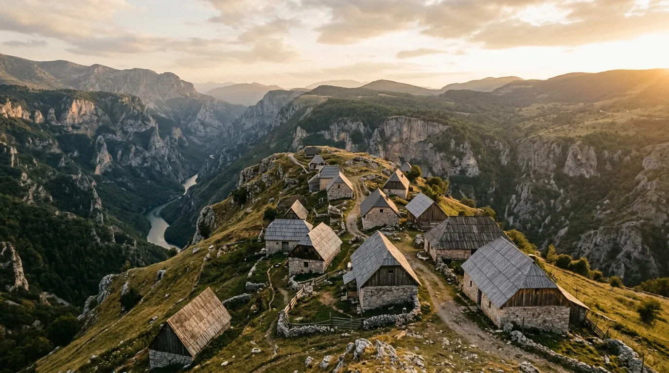
Lukomir is the kind of place that prompts the question: why is anyone still here? The village sits at 1,495 metres on the southern rim of Bjelasnica mountain, 35 km of unpaved road from the nearest paved surface, snowbound from November to May, and home to approximately 10 families who remain because this is where they have always been. The stone houses are centuries old. The architecture is medieval. The view from the village edge drops 800 metres into the Rakitnica Canyon, and on the other side of that canyon, the mountains continue in every direction with no visible sign of the 21st century.
We drove to Lukomir on a Wednesday morning in July. We left Sarajevo at 07:00, reached the village at 09:30, spent three hours walking, talking, and sitting on stone walls looking into the canyon, and drove back to Sarajevo for a late lunch. The total driving distance is approximately 70 km round trip, of which 35 km is unpaved. It is the shortest route in our Bosnia chapter and arguably the most affecting — not because of the driving, which is straightforward, but because of the destination, which is a place that exists at the edge of viability and knows it.
Getting there
Sarajevo to Babin Do (paved, 25 km)
From central Sarajevo, drive southwest toward the Bjelasnica ski center. The road is paved, well-signed, and passes through the suburbs of Ilidza before climbing into the mountains. At Babin Do — the base station of the Bjelasnica ski resort — the pavement effectively ends. There is a fuel station on the outskirts of Hadzici, approximately 15 km from central Sarajevo; this is the last fuel before Lukomir and should be used.
The Bjelasnica ski area has an odd atmosphere in summer: empty chairlift pylons, closed hotels, grass where the ski runs were. The 1984 Winter Olympics were held here, and the infrastructure — now aging — is a reminder of a Sarajevo that existed before the war. The bobsled track on nearby Mount Trebevic is the most famous ruin of that era, but Bjelasnica’s empty ski lodges have their own melancholy.
Babin Do to Lukomir (unpaved, 35 km)
From Babin Do, a gravel road heads south across the Bjelasnica plateau. The first 15 km are maintained gravel — the ski resort and the few highland hamlets generate enough traffic to keep the surface passable. The road crosses open meadow at approximately 1,200-1,400 metres, with views south to the Visocica and Treskavica ranges.
At approximately km 15, the road narrows and the surface deteriorates. From here to Lukomir, the track is rough — rocky sections, exposed limestone pavement, and ruts from seasonal water flow. The gradient is mostly gentle, but the surface demands attention. Ground clearance of 180 mm or more is the minimum; 200 mm is comfortable. A 2WD with clearance can manage in dry conditions by picking lines carefully. A 4x4 removes the need for line selection and is recommended if you are not confident reading surface.
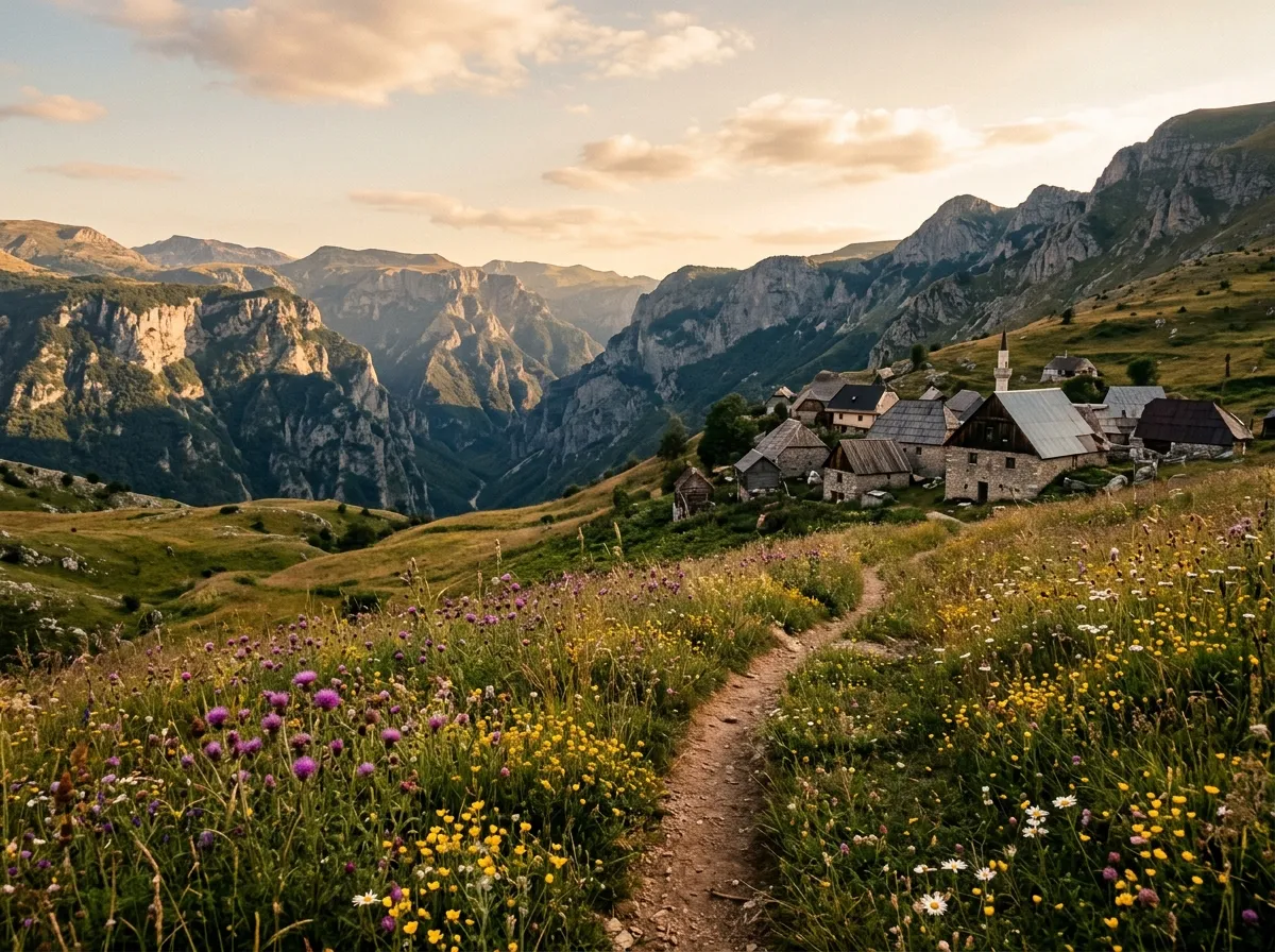
The landscape through this section is highland meadow — grass, wildflowers (spectacular in June and July), scattered limestone outcrops, and no trees. The plateau is wind-raked and exposed. In sunshine, it is beautiful in a stark, Nordic way. In fog or rain, it is featureless and the track disappears into the grass.
At km 30, the track begins its final approach to Lukomir. The village appears gradually — first a field wall, then a sheep pen, then the dark stone shapes of houses. The road enters the village from the north and ends in a rough parking area between the houses and the canyon rim.
The village
Lukomir is arranged in a tight cluster of stone houses along the rim of the Rakitnica Canyon. The houses are built from local limestone, dry-stacked, with thick walls and small windows oriented south. The roofs were traditionally stone-flagged; most are now corrugated metal, which is practical but less picturesque. The overall effect is of a settlement that grew from the rock it sits on — the building material and the bedrock are the same stone, and from a distance, the village blurs into the landscape.
The village has been inhabited continuously for centuries, though the population has declined steadily. At its peak, perhaps 50-70 families lived here. Today, the number is closer to 10, most of them elderly. In winter, when the road closes and snow buries the plateau, the residents who remain live on stored food, firewood, and stubbornness.
What to see
The architecture. Walk through the village slowly. The stone construction is beautiful in its simplicity — no mortar, no foundation beyond the bedrock, the walls following the natural contours of the ridge. Each house has a small walled yard that served as a livestock pen in winter. The construction technique is identical to buildings dated to the medieval Bosnian kingdom, and while the current structures may not be that old, the method is.
The canyon. Walk south from the houses to the rim of the Rakitnica Canyon. The drop is approximately 800 metres — not vertical everywhere, but steep enough that the river at the bottom is a thin thread of white water. The far wall of the canyon rises in a series of limestone cliffs to the Visocica plateau. The scale is difficult to process from a standing position. Sit on the edge (carefully) and give it five minutes.
The stecci. On the approach to the village, a cluster of medieval tombstones (stecci) stands in the meadow. These are the same type of carved stone markers found at Blidinje and other sites along the Via Dinarica — medieval, enigmatic, and inexplicably powerful standing alone in the grass.
The people. If villagers are present and approachable, a brief conversation (through gesture or the few words of English or Bosnian you can manage) is worthwhile. Several women sell handmade woolen goods — socks, slippers, bags — and local honey. The prices are modest and the purchase supports the people keeping this village alive. Do not photograph people without asking. Do not enter houses uninvited. The village is not a museum; it is someone’s home.
Practical details
| Item | Detail |
|---|---|
| Total distance | ~35 km one way (from Babin Do), ~70 km round trip |
| Driving time | 1.5-2 hours each way |
| Fuel | Hadzici (Sarajevo suburbs). No fuel on route. Full tank sufficient for round trip. |
| Water | Carry 2L per person. No water for sale in Lukomir. Village has a spring. |
| Season | June through September (road condition dependent). |
| Mobile coverage | None at Lukomir. Intermittent on the plateau. Coverage returns at Babin Do. |
| Facilities | None at Lukomir. No toilets, no shops, no emergency services. |
| Accommodation | None at Lukomir. Return to Sarajevo. |
Conditions and timing
Best conditions: July and August, after a dry spell. The track is firm, the meadows are green, and the visibility is usually good.
Worst conditions: After heavy rain, the rocky sections become slippery and the meadow tracks turn to mud. In fog, the featureless plateau becomes a navigation challenge — the track is hard to follow when you cannot see 50 metres ahead. If fog rolls in while you are at Lukomir, wait at the village until it lifts rather than driving blind on a rough track with no reference points.
Time investment: Allow 5-6 hours for the round trip from Sarajevo, including 2-3 hours at the village. It is a half-day commitment that feels proportionate to the destination.
Combining with other routes: The Lukomir road shares the Bjelasnica plateau with the southern section of the Via Dinarica Access Tracks. If you are driving the Via Dinarica route, the Lukomir detour adds approximately 3 hours and is the single best side-trip in the Bosnian highlands.
Why Lukomir matters
We include Lukomir not because the driving is exceptional — it is moderate at best, and the technical challenge is limited to surface reading — but because the destination is. This is a place where the 21st century has arrived as a rumour rather than a reality. The village is accessible by vehicle for five months of the year. The rest of the time, it is accessible by foot or not at all. The people who live here have chosen a life that most of Europe abandoned a century ago, and they have done so with open eyes and closed roads.
Driving to Lukomir is the closest thing in the Balkans to driving to the end of the world. The road runs out, the modern world runs out, and what remains is stone, grass, wind, and a canyon that has been there for a geological epoch. It is not exciting driving. It is important driving.
Return to the Bosnia hub for the full country overview.