
Via Dinarica Access Tracks
The Via Dinarica is a 1,260 km hiking trail that follows the Dinaric Alps from Slovenia to Albania — the Balkan equivalent of the Appalachian Trail, though younger, less crowded, and less consistently marked. The trail itself is for walkers. But the network of dirt roads that provide access to trailheads, mountain huts, and highland villages — those are for us.
These access tracks form a discontinuous corridor through the central Bosnian highlands that can be driven as a multi-day route, linking sections of gravel road through terrain that alternates between highland meadow, mountain forest, and the exposed ridgelines of the Dinaric Alps. We drove a 150 km selection of these tracks over two days, starting from the Neretva Valley near Jablanica and finishing on the Bjelasnica plateau south of Sarajevo. The route crosses three mountain ranges, passes through two nature parks, and visits villages where the stone architecture is medieval and the population is measured in single digits.
This is not a continuous road. It is a sequence of connected tracks with paved sections between them. You will drive 20 km of highland gravel, descend to a valley on asphalt, cross to the next mountain on pavement, and then climb back onto gravel for another 25 km. The rhythm is distinctive: civilization, mountain, civilization, mountain. The mountains are the point.
Route structure
The route divides naturally into four sections, connected by paved valley roads. We describe them west to east, following our driving direction, though the reverse works equally well.
| Section | Distance (unpaved) | Base town | Key feature |
|---|---|---|---|
| Blidinje Plateau | 35 km | Jablanica | Glacial lake, stecci tombstones |
| Prenj Mountain approaches | 30 km | Konjic | Mountain massif, forest tracks |
| Rakitnica Canyon access | 25 km | Konjic | Canyon overlook, highland villages |
| Bjelasnica Highland | 40 km | Sarajevo | Highland meadow, ski infrastructure |
Total unpaved driving: approximately 130 km. Total including paved connectors: approximately 200 km. Two days allows for comfortable driving with exploration stops. One ambitious day is possible but leaves no margin for weather delays or getting lost, and we got lost twice.
Day 1: Blidinje and Prenj
Blidinje Plateau (morning)
The route begins at the junction near Jablanica in the Neretva Valley — a small town that is relevant because it has fuel, a supermarket, and the last reliable services before 60 km of mountain driving. From Jablanica, a paved road climbs west toward Blidinje Nature Park. The pavement ends at the park boundary, and a gravel road continues onto the Blidinje plateau at approximately 1,200 metres elevation.
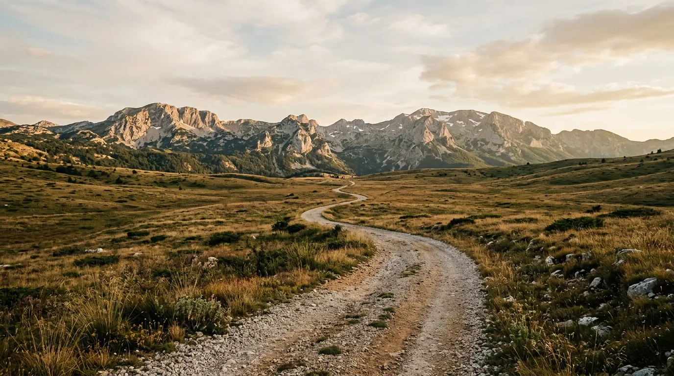
Blidinje is a high-altitude plateau surrounded by peaks reaching 2,000 metres. The centerpiece is Blidinje Lake — a glacial lake that freezes in winter and shimmers in summer — set against the limestone wall of the Cvrsnica massif. The gravel road crosses the plateau on a well-graded surface suitable for a 2WD with clearance. Side tracks branch to viewpoints and the medieval tombstone sites.
The tombstones are stecci — carved stone grave markers from the medieval Bosnian kingdom, dating to the 12th-16th centuries. Several clusters along the Via Dinarica access tracks are UNESCO World Heritage Sites. They stand in highland meadows at impossible angles, their carved surfaces showing human figures, animals, and astronomical symbols that nobody has definitively interpreted. They are the kind of thing you expect to find in a museum, not in a sheep pasture at 1,200 metres, which is precisely what makes encountering them on a dirt road more powerful than seeing them behind glass.
The Blidinje plateau tracks total approximately 35 km. The surface is good gravel throughout, with gentle gradients and wide sightlines. This is the easiest section of the route and a gentle introduction to Bosnian highland driving.
Prenj approaches (afternoon)
From Blidinje, descend to Konjic via the paved road — approximately 45 km, passing through the Neretva Valley. Konjic is a pleasant town on the river with fuel, restaurants, and accommodation. It is the logical overnight stop if you split the route across two days.
From Konjic, the Prenj mountain approaches head south on gravel roads that climb into the forest below the Prenj massif — one of Bosnia’s most dramatic mountains, a limestone fortress of cliffs and pinnacles that rises to 2,155 metres. The access tracks do not reach the summit zone (that requires hiking), but they penetrate the forest on the mountain’s flanks and provide driving through terrain that feels genuinely wild.
The track from the Konjic side follows a tributary valley south for 12 km through beech forest, climbing from 400 metres to approximately 1,100 metres. The surface transitions from gravel to forest earth at about km 7. Two stream crossings — both shallow (under 20 cm) with firm gravel bottoms — punctuate the drive. The forest is dense and dark, the track is narrow, and the sense of enclosure is complete. At km 12, the forest opens to a clearing with views of the Prenj ridge — the limestone wall fills the southern sky, and you understand why the mountain has a reputation among Bosnian mountaineers.
A second track from the northern approach follows a shepherd road to a meadow at 1,300 metres, totalling approximately 18 km one-way. The surface is rougher — rocky in places, with one section of exposed limestone pavement that is uncomfortable at any speed. A 4x4 is recommended for both Prenj tracks.
Day 2: Rakitnica Canyon and Bjelasnica
Rakitnica Canyon access (morning)
From Konjic, the route continues east on paved roads for 30 km to the village of Umoljani on the Bjelasnica plateau. From Umoljani, a gravel track heads south along the rim of the Rakitnica Canyon — an 800-metre-deep gorge that cuts through the limestone plateau between Bjelasnica and Visocica mountains.
The canyon overlook track follows the western rim for approximately 10 km on a gravel surface that deteriorates from maintained to rough. The views into the canyon are vertigo-inducing — the walls drop nearly vertically, and the river at the bottom is a thin blue-green thread far below. There are no guardrails. There are no fences. There is a gravel track and then there is air.
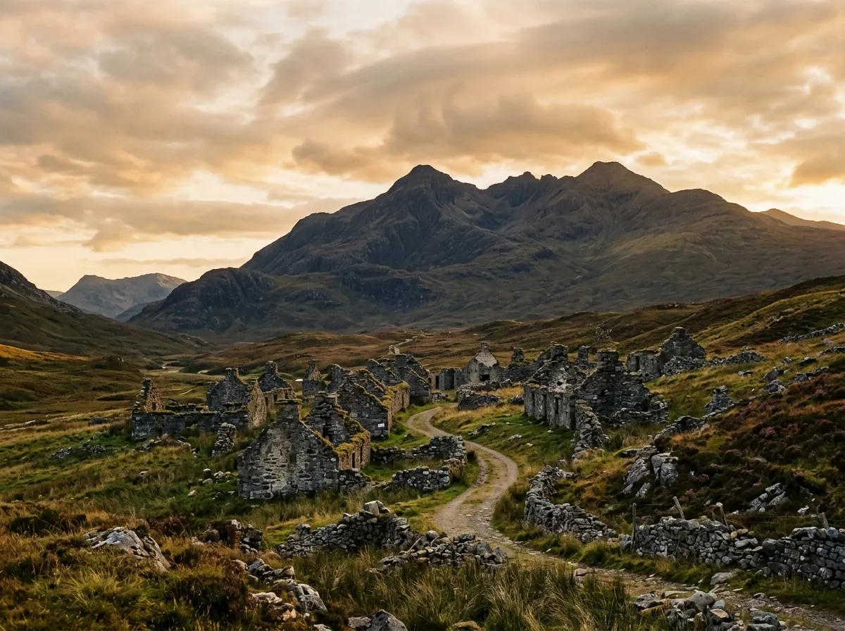
Along this track, you pass several abandoned highland settlements — stone houses with collapsed roofs and walls still standing, surrounded by meadow that is slowly reclaiming the village sites. These settlements were depopulated over decades — some during the war, some through the slower process of rural-to-urban migration that empties mountain villages across the Balkans. The stone construction is beautifully simple: walls of local limestone, timber roof beams, small windows facing south. Walking through them (carefully — the structures are unstable) is a lesson in how people built and lived in these mountains for centuries.
Bjelasnica Highland tracks (afternoon)
From Umoljani, the route turns north onto the Bjelasnica plateau — a highland area that hosted the 1984 Winter Olympics and now functions as Sarajevo’s closest ski area. In summer, the ski infrastructure is dormant and the highland meadows are accessible by a network of gravel tracks.
The Bjelasnica tracks cover approximately 40 km of highland terrain between 1,200 and 1,800 metres. The surface varies from maintained gravel (near the ski areas) to rough meadow tracks (further from infrastructure). The driving is not technically difficult — the gradients are moderate and the surfaces are firm in summer — but the navigation can be confusing where multiple tracks cross open meadow with no signage.
The highlight of the Bjelasnica section is the drive to the Lukomir approach — the same track that serves our dedicated Lukomir Highland Road guide. If you have not already driven to Lukomir, the Via Dinarica route passes within 8 km of the village and the detour is the best half-day extension of this route.
The Bjelasnica tracks eventually descend north toward Sarajevo via paved roads from the ski center at Babin Do. The total descent from the highland to Sarajevo is approximately 35 km and takes 45 minutes on pavement.
Practical details
| Item | Detail |
|---|---|
| Total distance | ~150 km unpaved, ~200 km including connectors |
| Driving time | 2 days (6-8 hours per day) |
| Fuel | Jablanica, Konjic, Sarajevo. Carry 10L jerry can. |
| Water | 3L per person per day. Limited water sources in highlands. |
| Season | June through October. Snow possible above 1,500m in October. |
| Mobile coverage | Good in valleys (Konjic, Sarajevo). Intermittent to none in highlands. |
| Accommodation | Konjic: hotels and pensions, 25-50 EUR. Umoljani: homestays (limited, book ahead). |
| Permits | Blidinje Nature Park: no enforced entry fee. Bjelasnica: no permits. |
Vehicle and conditions
A 4x4 is recommended for the full route. The Blidinje section is manageable in a 2WD with clearance. The Prenj approaches and Rakitnica Canyon track are 4x4 territory — the surface and gradients demand it. The Bjelasnica tracks are borderline — dry conditions favour a good 2WD, wet conditions require 4x4.
The Dacia Duster 4x4 handled the entire route on our drive (August, dry conditions). The forest tracks below Prenj were the most challenging sections — narrow, soft earth, with one muddy descent where the front wheels lost traction and the rear 4WD engagement saved a slide. Nothing that required recovery gear, but enough to justify the 4x4 choice.
Carry a tow strap and know how to self-recover using a tree anchor. The Bosnian highlands are not remote in the way that the Prokletije or Sinjajevina are, but traffic on the highland tracks is thin enough that waiting for another vehicle to help could mean waiting for hours.
Connections
The Via Dinarica Access Tracks form the spine of a Bosnian off-road itinerary. Add the Lukomir Highland Road for a half-day detour to Bosnia’s most isolated village. Add Sutjeska National Park Trails for a day of forest driving in a different ecosystem. The three routes together form a 4-5 day itinerary that covers the full range of Bosnian off-road terrain.
Return to the Bosnia hub for the full country overview.