
Sutjeska National Park Trails
Sutjeska is Bosnia’s oldest national park and one of the wettest places in the Balkans. The park sits in the southeastern corner of the country, hard against the Montenegrin border, and contains two things that are rare in Europe: the Perucica primeval forest — one of the last remaining old-growth forests on the continent — and the Bosnian section of the Tara River canyon, which is also the deepest river canyon in Europe after the Verdon Gorge (or deeper, depending on whose measurement you trust).
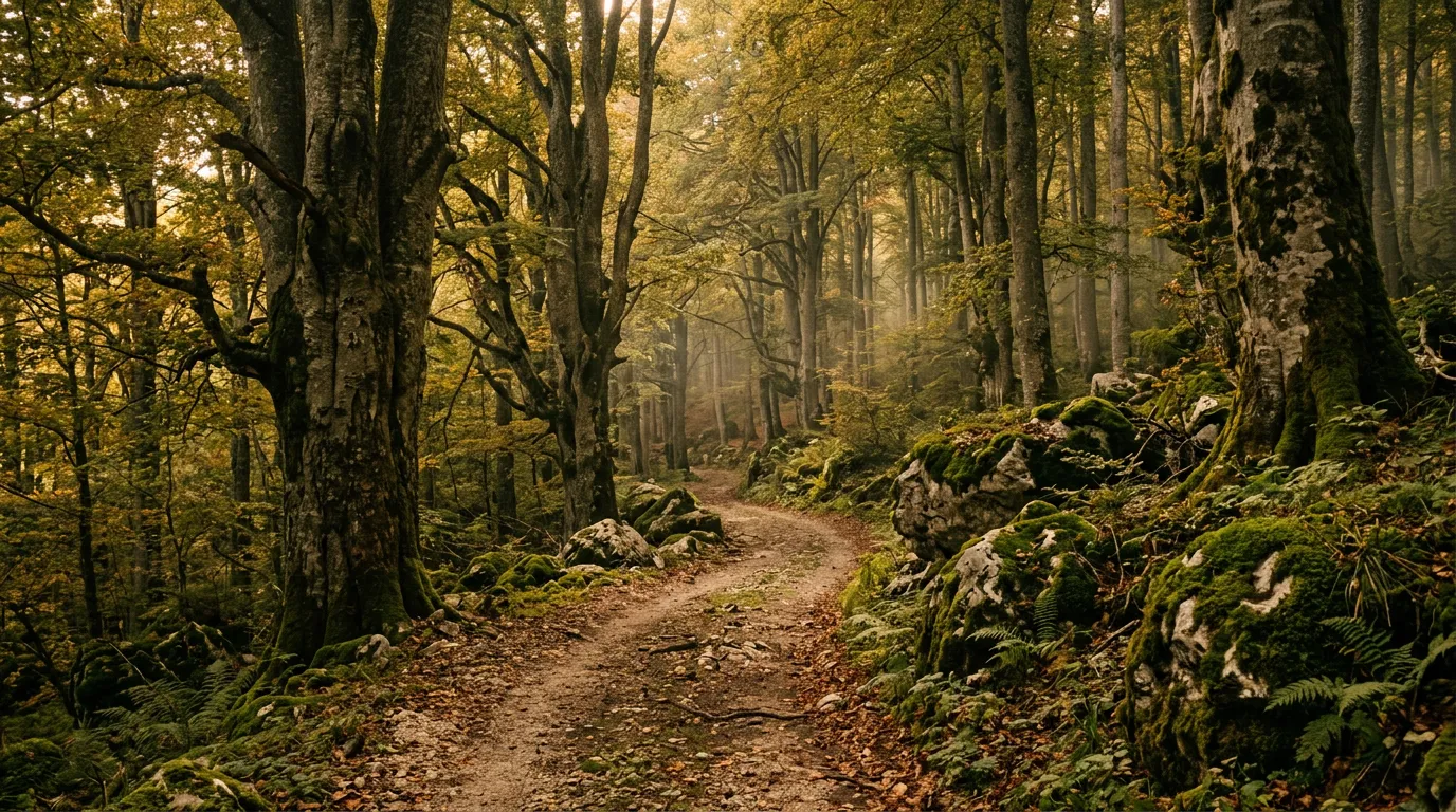
The driving here is different from anything else in our Balkan catalogue. Albania is about switchbacks and exposure. Montenegro is about highland plateau and rock. Romania is about altitude and forest. Sutjeska is about water. Water falling from the sky (it rains here frequently and enthusiastically). Water running across the track (stream crossings are constant). Water in the ground (the surface is permanently damp, and mud is the default condition rather than the exception). The forest is wet, green, dark, and old. The trees in Perucica are 300 years old and 50 metres tall. The moss is thick enough to sleep on. The air smells of decomposing leaves and mineral water and deep geological time.
We drove approximately 70 km of tracks within and around the park over a single day, starting from the park headquarters at Tjentiste and exploring three loops: the Perucica viewpoint access, the Tara canyon approach, and the Maglic mountain approach. The driving is moderate in difficulty — the gradients are not steep, the technical challenge is limited — but the wet conditions demand 4WD and the atmosphere demands your attention. This is the most beautiful forest driving in the Balkans, and it is also the muddiest.
Getting there
Sutjeska National Park is approximately 3 hours by road from Sarajevo via Foca. The approach is paved throughout — the road follows the Drina River valley east from Sarajevo to Foca, then turns south along the Sutjeska River to the park boundary at Tjentiste.
Foca is the last town with full services: fuel stations, a supermarket, ATMs, restaurants, and accommodation. The town has a complicated history — it was a focal point of the Bosnian war — and a straightforward present as a small riverside town that serves as the gateway to the park. Fill your tank here.
Tjentiste is the park headquarters, located in a wide valley at approximately 500 metres elevation. There is a hotel (the Hotel Mladost, built during the Yugoslav era and showing its age), a park ranger station, a small museum, and the Tjentiste war memorial — a WWII monument commemorating the Battle of Sutjeska, rendered in massive concrete forms that are genuinely arresting as architecture regardless of their historical context. The memorial was designed by Miodrag Zivkovic and completed in 1971, and it looks like nothing else in the Balkans or anywhere. Stop here.
The three loops
Loop 1: Perucica viewpoint access (15 km round trip)
Perucica is a strict nature reserve within the park — 1,434 hectares of forest that has never been logged. Entry to the forest on foot requires a guide booked through the park rangers. But the access track to the forest viewpoint is open to vehicles, and it provides a drive through secondary-growth forest that is impressive enough on its own terms before you even see the primeval section.
From Tjentiste, a gravel track heads south along the Perucica stream valley. The surface is compacted gravel for the first 3 km, then transitions to forest earth — soft, dark, and decorated with roots. The track is one lane, shaded by beech canopy, and wet. Even in August, after a week of dry weather, the surface was damp. Ruts from previous vehicles hold standing water. The driving is slow — 15-20 km/h — not because of difficulty but because the surface demands precision. Pick the firmest line. Avoid the deepest ruts. Keep momentum through the soft sections without accelerating into the trees.
At km 7.5, the track reaches a small clearing with a viewpoint over the Perucica forest. The view is modest in scope but overwhelming in implication: below you, the canopy stretches unbroken to the ridgeline, and the trees are visibly larger than anything else you have seen. European beech at 300 years old and 45-50 metres tall looks different from managed forest beech — the crowns are massive and irregular, the trunks are thick and scarred, and the overall impression is of a forest that is governing itself.
If you book a guided walk into the forest (available through the park rangers, approximately 30 EUR per person), you walk beneath those trees and the scale becomes personal. The guided walk is beyond our driving scope but worth mentioning: it is one of the most remarkable nature experiences in Europe.
Loop 2: Tara canyon approach (25 km round trip)
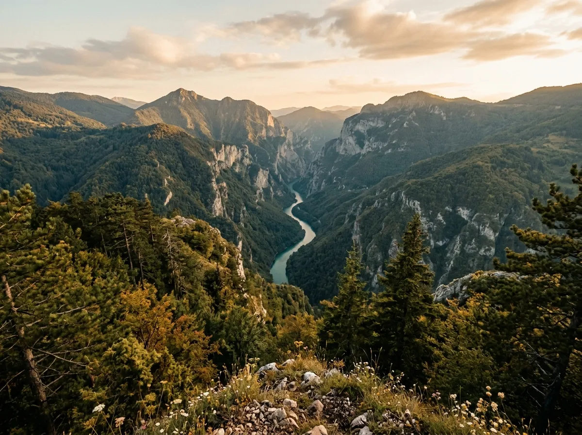
From Tjentiste, a second track heads northeast along the Sutjeska River before climbing to a ridge above the Tara River canyon. The Tara forms the border between Bosnia and Montenegro here, and the canyon — which is deeper and narrower than its Montenegrin section near Durmitor — cuts through limestone in a gorge that drops several hundred metres from rim to water.
The track follows a maintained gravel road for the first 8 km along the river valley. The surface is good — graded gravel, reasonable width, some traffic from local vehicles. At km 8, the track turns north and begins to climb toward the canyon rim on a steeper, narrower track through mixed forest. The gradient is moderate (10-15 percent) and the surface is compact gravel over rock — firmer than the Perucica track because of the better drainage on the slope.
The canyon viewpoint at approximately km 12 is informal — a widening of the track where the trees thin and the ground drops away. The Tara River is visible far below, blue-green in its canyon. The far wall — Montenegro — rises in limestone cliffs. On a clear day, the Durmitor massif is visible to the northwest, which creates a satisfying geographical connection if you have driven our Durmitor Ring Road on the other side.
The return follows the same track. Total round trip: approximately 25 km. Driving time: 2-3 hours including viewpoint stops.
Loop 3: Maglic approach (30 km round trip)
Maglic is Bosnia’s highest peak at 2,386 metres, sitting on the Montenegrin border south of Tjentiste. The summit requires a hike, but a forest track approaches the mountain from the north, providing driving through high-altitude forest to approximately 1,500 metres before the track becomes a footpath.
From Tjentiste, the track heads south through the Sutjeska valley and then climbs west into the forest on the northern flanks of Maglic. The first 10 km are valley road — gravel, moderate, and damp. The climbing section from km 10 to km 15 is steeper and rougher — the surface deteriorates as altitude increases, with mud, exposed rock, and one section of eroded track where the water has carved a channel down the centre of the road.
At approximately 1,200 metres, the character of the forest changes from beech to mixed beech-fir, and then to predominantly fir. The trees thin, the light increases, and the track opens intermittently to views of the Sutjeska valley below. At km 15, the track reaches a meadow at approximately 1,500 metres where it effectively ends for vehicles — the path continues toward the summit as a hiking trail.
This is the most demanding of the three loops. The gradient above 1,200 metres requires a 4x4 in any conditions, and the surface after rain would be genuinely difficult — steep mud on a mountain track is the combination that earns recovery stories. In dry conditions, it is moderate and manageable. In wet conditions, assess the surface at the start of the climbing section and turn back if the ruts are running with water.
Vehicle and conditions
A 4x4 with all-terrain tires is the right setup for Sutjeska. The Perucica track and the Maglic approach are the most demanding sections — soft earth, standing water in ruts, and mud that is present regardless of recent rainfall. The Tara canyon track is the easiest of the three and might be manageable in a 2WD with clearance in dry conditions, though we would not recommend it.
We drove all three loops in a Dacia Duster 4x4 with factory tires. The tires were the weakest link — highway-terrain rubber on soft mud is a grip compromise. All-terrain tires would have made the Perucica track and the Maglic approach noticeably easier. If you have a choice at the rental counter, specify AT tires. If not, drive conservatively and avoid the deepest ruts.
Tire pressure: we dropped to 1.5 bar on the forest tracks for better grip on the soft surface. The lower pressure increases the tire footprint and distributes weight over more area, which is exactly what you want on mud. Re-inflate before the paved return to Foca.
Rain gear: for you, not the vehicle. If you stop to walk at viewpoints, look at the memorial, or take photographs, you will stand in mud and possibly rain. Waterproof boots are not optional. Gaiters are useful. A rain jacket should be in your day bag regardless of the forecast, because the forecast in the Sutjeska valley is “might rain” on every day of the year.
Practical details
| Item | Detail |
|---|---|
| Total distance | ~70 km (all three loops) |
| Driving time | 6-8 hours for all three loops |
| Start/end | Tjentiste park headquarters (43.3500 degrees N, 18.6833 degrees E) |
| Fuel | Foca (30 km north). No fuel in the park. |
| Park entry | Small fee collected at Tjentiste (approximately 3 EUR, 2024). |
| Water | 3L per person. Stream water requires filtering. |
| Mobile coverage | None on forest tracks. Some coverage at Tjentiste. |
| Accommodation | Hotel Mladost at Tjentiste (basic, 30-50 EUR). Foca: better options. |
| Guided walks | Perucica forest walk bookable through park rangers. ~30 EUR/person. |
Timing and itinerary
Start early from Foca or Tjentiste. Drive the Perucica access first (morning light in the forest is extraordinary — the canopy filters the sun into columns that move across the track as you drive). Break at Tjentiste for the memorial and a coffee at the hotel. Drive the Tara canyon approach over midday. Drive the Maglic approach in the afternoon if conditions and energy allow.
If you can only do one loop: Perucica. The forest driving is the most atmospheric, the viewpoint is the most rewarding, and the route is the most representative of what Sutjeska offers.
If you can do two: Perucica and the Tara canyon. The combination of primeval forest and canyon views covers the park’s two signature features.
Connections
Sutjeska is the most isolated of our Bosnian routes — it does not connect directly to the Via Dinarica Access Tracks or the Lukomir road without significant paved driving through Sarajevo. It works best as a standalone day trip from Foca, or as the final stop on a Bosnian itinerary before crossing into Montenegro via the border at Hum.
From the Montenegrin side, Sutjeska is approximately 2 hours from Zabljak (via Pluzine), making it possible to combine with the Durmitor Ring Road or Sinjajevina Highland Tracks in a cross-border itinerary.
Return to the Bosnia hub for the full country overview.