Danakil Approach Road
The thermometer in the vehicle read 52 degrees Celsius. This was the outside air temperature, measured by a sensor on the wing mirror, at approximately 2 PM on a day in late November. The ground temperature — measured by an infrared thermometer that one of the Afar guides carried — was 68 degrees. The sky was a white haze that did not resemble sky so much as an absence of atmosphere, as though the air had given up on the project of being transparent and settled for a diffuse glare that hurt the eyes even through sunglasses. The landscape was salt crust and volcanic rock extending to the horizon in every direction, interrupted by formations of sulphur deposits in colors that do not occur in normal geography — bright yellow, acidic green, vivid orange, colours that belong in a chemical laboratory rather than on the surface of a planet.
We were at approximately minus 48 metres below sea level, in the Danakil Depression, in the Afar region of northeastern Ethiopia. The depression is one of the lowest, hottest, and most geologically active places on Earth — a section of the East African Rift where the crust has thinned to the point that volcanic and hydrothermal activity occurs at the surface, and where the average annual temperature of 34.4 degrees Celsius makes it the hottest inhabited place for which records exist. People live here. The Afar people have lived here for centuries, mining salt from the dried lake beds and transporting it by camel caravan to the highland markets. The fact that they do this in conditions that would challenge industrial machinery is a testament to human adaptability that no amount of air-conditioned tourism can fully appreciate.
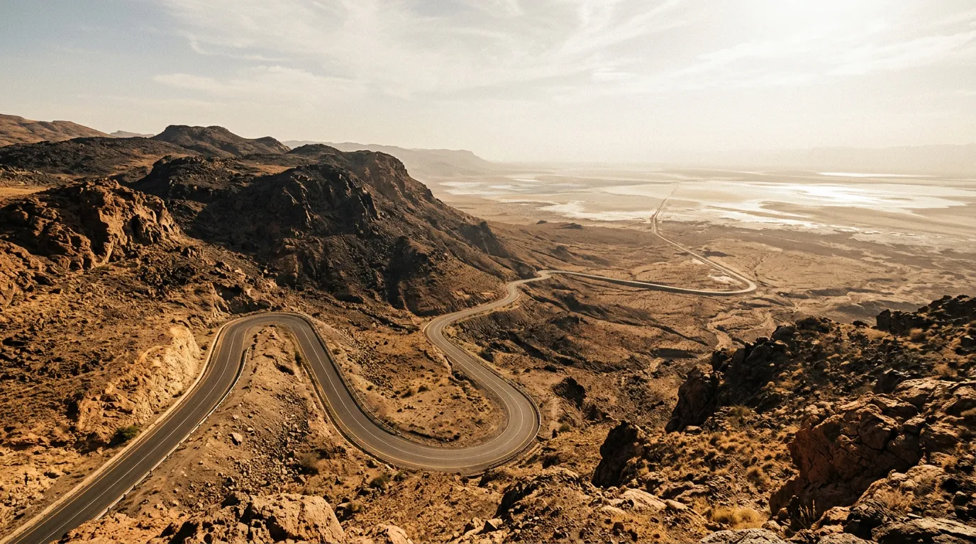
The approach road — the route from the highland city of Mekelle to the depression floor — covers 230 km and descends 2,325 metres. It is, by every measure we use, an expert-level route: the most demanding, the most logistically complex, and the most physically punishing drive we have completed.
What you need to know before reading further
The Danakil is not a self-drive adventure in the conventional sense. Let us be clear about this:
-
Independent travel is not permitted. The Afar regional government requires all visitors to travel with a licensed guide and armed Afar escort. This is not a recommendation — it is a legal requirement enforced at checkpoints.
-
Convoy travel is mandatory. A minimum of two vehicles is required. Breakdowns happen. In an environment where daytime temperatures exceed 50 degrees Celsius and the nearest town is 100+ km away, a single vehicle breakdown is a potential emergency.
-
The security situation is variable. The Afar region has experienced periods of instability. Check current conditions through your tour operator and your country’s travel advisories before committing to the trip. We traveled in a period of calm. This does not guarantee your period will be the same.
-
The physical conditions are extreme. Heat exhaustion, dehydration, and heat stroke are real risks. Travelers with cardiovascular conditions, respiratory issues, or a low tolerance for heat should consider whether this route is appropriate.
If these conditions are acceptable, continue reading. The Danakil is unlike anything else on Earth.
Route overview
The approach road from Mekelle to the Danakil Depression can be divided into three distinct sections, each with its own character and its own demands.
| Section | Distance | Elevation change | Terrain | Key features |
|---|---|---|---|---|
| Mekelle to escarpment edge | ~80 km | 2,200m → 1,200m | Paved then gravel, agricultural highland | Highland descent, last services |
| Escarpment to Afar lowlands | ~80 km | 1,200m → 200m | Rough gravel, volcanic rock | Desert transition, increasing heat |
| Afar lowlands to depression floor | ~70 km | 200m → −125m | Salt crust, volcanic track, sand | Salt flats, sulphur fields, Dallol |
The total journey takes 8-12 hours of driving in each direction. Most tours spread this over 2-3 days with camps in the depression, allowing time for the geological sites (Dallol, Erta Ale) and the salt mining operations.
Organizing the trip
Mekelle operators
All Danakil trips are organized through operators based in Mekelle (13.4967° N, 39.4750° E). The standard package includes:
- Licensed English-speaking guide
- Armed Afar escorts (typically 2-4)
- Lead vehicle (usually a Toyota Land Cruiser driven by the operator)
- Cooking equipment and basic food
- Sleeping mats for open-air camping
- Permits and checkpoint clearances
Cost: $200-400 per person for a 2-3 day trip, depending on group size, inclusions, and whether you are using the operator’s vehicle or driving your own. If driving your own vehicle, the cost is lower (guide and escort fees only, approximately $150-250 per person), but you must demonstrate that your vehicle is adequate for the conditions. The operator will inspect it.
Recommended operators: We used ETT (Ethiopian Travel & Tours) and found them competent and well-organized. Several other operators in Mekelle offer similar services. Ask for references from recent travelers. The quality of the guide and the condition of the lead vehicle matter — this is not a trip where you want to economize on logistics.
Preparation in Mekelle
Mekelle is a regional capital with fuel stations, supermarkets, and a reasonable level of services. Prepare here:
- Fuel: Fill main tank and all jerry cans. 60 litres of reserve fuel minimum. The round trip from Mekelle exceeds 500 km, and the desert driving increases consumption by 30-40 percent.
- Water: 80 litres minimum for two people over three days. This sounds excessive. It is not. At 50+ degrees Celsius, you will drink 6-8 litres per person per day and use additional water for cooling (pouring water on a cloth and draping it over your neck is the most effective cooling method we found).
- Food: High-calorie, heat-stable food. Nuts, dried fruit, canned goods, bread. Appetite decreases dramatically in extreme heat. Eat anyway — your body needs the calories.
- Electrolytes: Oral rehydration salts or electrolyte tablets. Sweating at Danakil rates depletes salt and minerals faster than plain water can replace them.
Day 1: Mekelle to the depression floor
The highland descent
The first 80 km from Mekelle follows a paved road that deteriorates to gravel as it descends from the highland plateau. The landscape transitions from green, terraced agriculture — the Ethiopian highlands are intensively farmed — to drier scrubland as the elevation drops below 1,500 metres. The temperature rises noticeably. At Mekelle (2,200 metres), the morning temperature was 18 degrees Celsius. By the time we reached the 1,000-metre mark, it was 32. By the base of the escarpment, 38.
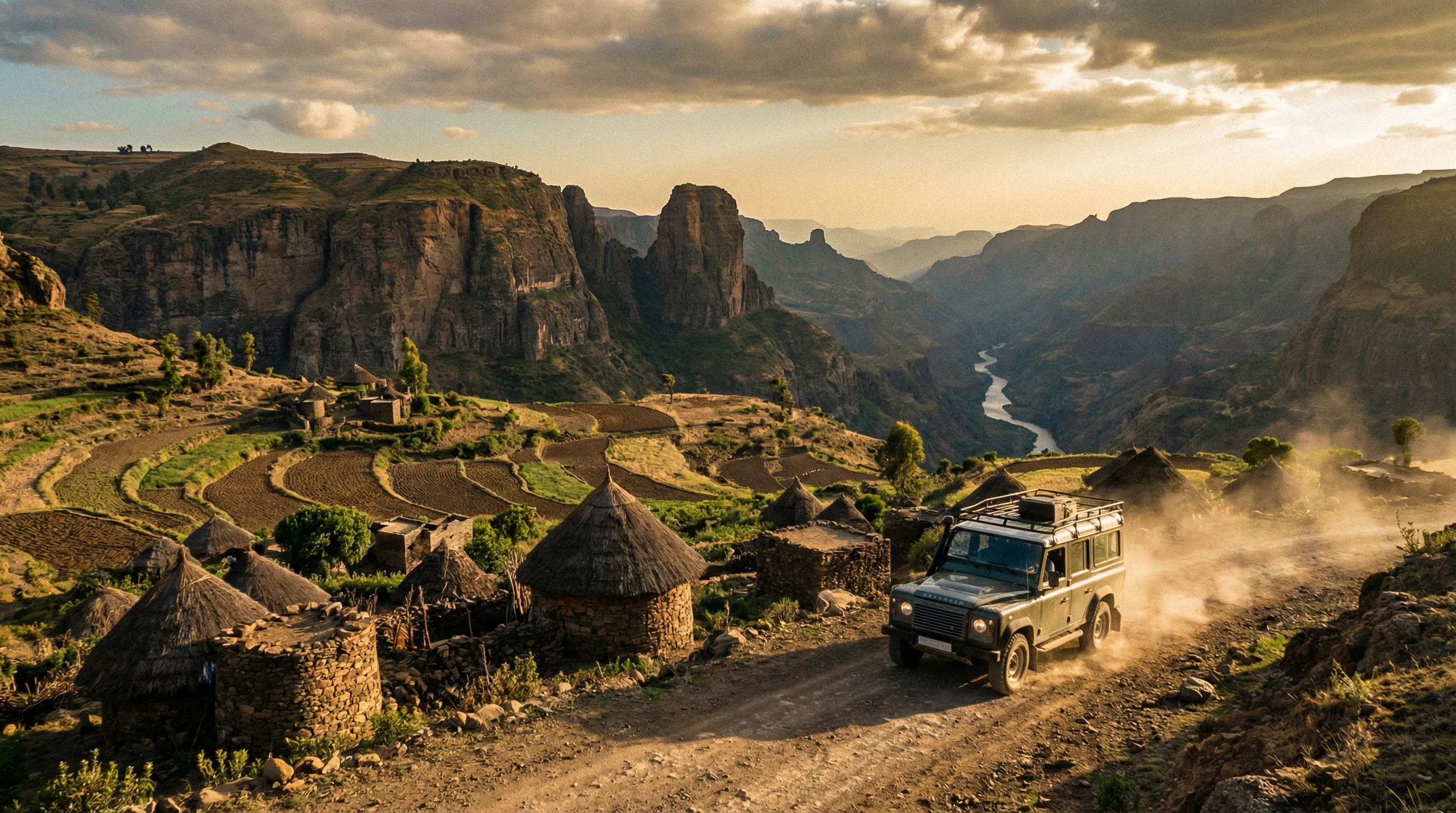
The road passes through several small towns where the last services are available — fuel, water, basic food. Our guide stopped at a settlement called Berhale (approximately 100 km from Mekelle, elevation 500 metres) for a final water resupply and to pick up the Afar escort. Berhale is the gateway to the Afar lowlands, and the transition from highland Ethiopia to Afar territory is immediately visible — the language on signs changes, the people’s appearance and dress change, and the landscape shifts from agricultural to pastoral desert.
Entering the Afar lowlands
Below Berhale, the road enters the Afar Triangle — a geological depression where three tectonic plates (African, Somali, and Arabian) meet and are pulling apart. The terrain is the visible result of this process: volcanic rock, dried lava flows, basalt plains, and the occasional active fumarole venting steam and sulphur gases from the ground. The road — now a track, in practice — follows a route marked by previous tire tracks across the volcanic surface. There is no grading, no signage, and no distinction between road and not-road apart from the compression of the volcanic gravel by previous vehicles.
The heat increases with every kilometre of descent. The vehicle’s air conditioning works hard and achieves a differential of approximately 15 degrees from outside temperature — meaning that at 48 degrees outside, the cabin is 33 degrees inside. This is not comfortable, but it is survivable. Without air conditioning, the depression is dangerous for anyone spending extended time in a vehicle.
Below sea level
The moment of crossing sea level is marked by nothing — no sign, no change in terrain, just the altimeter reading zero and then ticking into negative numbers. The landscape at this point is salt crust: a flat, white expanse that extends to the horizon and shimmers with heat mirages that turn the distance into an impressionist painting of silver and pale blue. The salt crust is the bed of a lake that evaporated thousands of years ago. Beneath the crust, the ground is still salt, compressed to a depth of several kilometres by geological time.
Driving on the salt crust is smooth and fast — the surface is flat and hard, and the vehicle moves at highway speed. The danger is navigation: the featureless white surface makes distances and directions difficult to judge, and the heat mirages create phantom features that do not exist. Our guide navigated by GPS and by knowledge of landmarks invisible to us — a slight discoloration in the salt surface, a rock outcrop barely above the horizon.
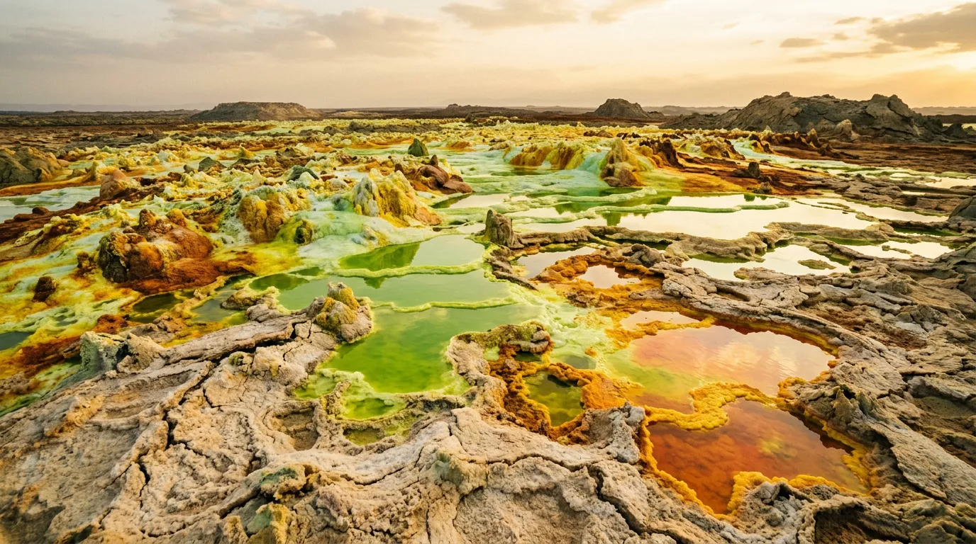
Dallol
The sulphur springs (14.2417° N, 40.3000° E)
Dallol is a hydrothermal field approximately 48 metres below sea level — a concentration of hot springs, sulphur deposits, salt formations, and acidic pools that represents some of the most extreme geology accessible by vehicle anywhere on Earth. The formations are the product of underground volcanic activity forcing mineral-laden water through the salt crust, where it deposits sulphur, iron oxide, and other minerals in patterns that look less like natural geology and more like a chemistry experiment conducted on a planetary scale.
The colors are the most immediately striking feature. The deposits range from bright canary yellow (sulphur) through vivid green (iron-sulphur compounds) to deep orange and rust (iron oxide). The pools of hydrothermal water are turquoise, emerald, and dark amber. The ground is warm underfoot — in some areas, hot enough to be uncomfortable through boot soles.
Dallol safety:
| Hazard | Detail | Precaution |
|---|---|---|
| Thin crust | The salt crust over some pools is thin. Breaking through puts you in acidic water at 70°+ | Follow the guide. Step only where they step. |
| Acid pools | pH as low as 0.2 in some pools. Contact causes chemical burns. | Do not touch any colored water. Do not kneel or sit near pools. |
| Toxic gas | Sulphur dioxide and hydrogen sulphide vent from fumaroles | Stay upwind of active vents. If you smell strong gas, move. |
| Heat | Ground temperature 60-70°C. Air temperature 45-55°C. | Limit exposure to 1-2 hours. Drink constantly. |
We spent approximately 90 minutes at Dallol. This was enough to see the major formations, take photographs, and begin to feel the heat in a way that moved from uncomfortable to concerning. The guide monitored the group and called the visit when one member (not us, but a Dutch traveler in the convoy) showed signs of heat exhaustion — pale skin, confusion, reduced sweating. He was treated with water, shade, and the vehicle’s air conditioning, and recovered within an hour.
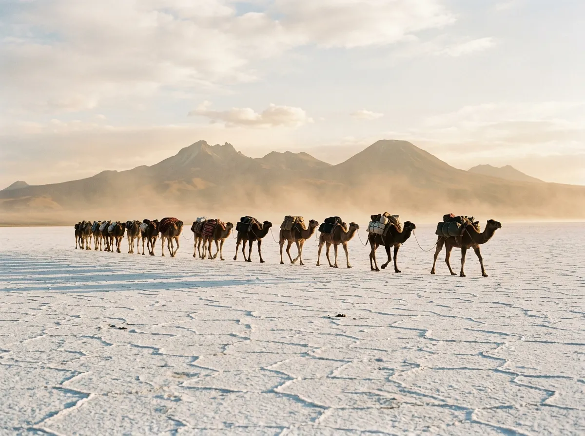
The salt miners
Adjacent to Dallol, the Afar salt mining operation continues as it has for centuries. Workers cut blocks of salt from the crust using hand tools — axes and levers — scoring the surface into rectangular slabs approximately 50 cm x 30 cm x 10 cm. The slabs are loaded onto camels — each camel carries 8-10 blocks, approximately 30-40 kg per block — and transported in caravans of 20-50 camels to Berhale and beyond, where the salt is sold.
The miners work in the early morning and late afternoon, avoiding the midday heat. We watched a salt-cutting operation from approximately 50 metres — close enough to see the technique, far enough to not interfere. The precision of the cutting was impressive: straight edges, consistent thickness, produced by hand tools on a surface that was radiating heat upward at intensity that made the air above it shimmer.
The camel caravans crossing the salt flats are one of the Danakil’s most photographed sights — long lines of loaded camels moving across the white surface, led by Afar herders in white cotton, casting long shadows in the low sun. We saw a caravan of approximately 30 camels departing in the late afternoon, and the image — a scene that could belong to any century in the past 2,000 years, set against the surreal backdrop of the sulphur fields — was worth the entire trip.
Camp in the depression
Open-air sleeping
Camping in the Danakil Depression is an exercise in heat management. There are no facilities, no structures, and no shade apart from what you create. The standard arrangement is sleeping mats laid on the salt crust or volcanic rock, with the vehicle providing a windbreak. Tents are not used — they trap heat and become uninhabitable within minutes of sunrise.
The night temperature drops to 30-35 degrees Celsius. This is the coolest it gets. Sleep is difficult but possible if you are tired enough, and after a day of 50-degree heat, you are tired enough. We slept on mats beside the vehicle, wearing lightweight clothing, and dozed intermittently from approximately 10 PM to 4 AM. The stars were extraordinary — the depression has zero light pollution, and the clarity at low humidity is remarkable.
The Afar escorts sleep in a loose perimeter around the camp. Their function overnight is security — the depression is remote and sparsely populated, and while incidents are rare, the escort presence is reassuring. They sleep lightly and with their rifles accessible.
Water management
We drank approximately 7 litres each during the first day in the depression. This is not an exaggeration — the combination of 50-degree heat, low humidity (which makes sweat evaporate before you feel wet), and physical activity (walking at Dallol, setting up camp) produces a fluid loss rate that is genuinely alarming if you are not prepared for it.
Signs of dehydration in extreme heat: dark urine (monitor this constantly), headache, dizziness, reduced sweating (a dangerous sign — it means your body is running out of fluid to sweat). Treat by drinking immediately. Oral rehydration salts are more effective than plain water once dehydration has begun.
Day 2: Return to the highlands
The ascent
The return journey follows the same route in reverse: salt flats to volcanic lowlands to Afar lowlands to escarpment to highland. The temperature drops progressively with altitude gain, and the moment when the air temperature drops below 35 degrees — somewhere around 1,000 metres — produces a physical relief that feels disproportionate to the numbers. After 24 hours in 50-degree heat, 35 degrees feels like air conditioning.
The driving on the return is mechanically demanding: the climbing sections that were easy descents on the way down now require low-range and sustained engine effort, and the volcanic rock sections that were fast on hard surface may have deteriorated (wind shifts loose rock, sand drifts across the track). Our guide navigated the return at a slightly faster pace than the descent, which suggested either familiarity or a desire to be out of the depression before the afternoon heat peak.
Vehicle assessment
After the Danakil, check your vehicle thoroughly:
| Item | What to check | Why |
|---|---|---|
| Tires | Cracks, embedded volcanic rock, sidewall damage | Sharp volcanic rock is abrasive and puncture-prone |
| Air filter | Salt and dust accumulation | The salt crust produces fine salt dust that clogs filters |
| Radiator | Salt crystallization on fins | The salt spray at lower elevations coats the radiator |
| Undercarriage | Salt accumulation, corrosion starting | Salt crust is corrosive. Wash the undercarriage in Mekelle. |
| Coolant level | May have consumed excess coolant | Engine works harder in extreme heat |
We had one issue: a slow tire puncture from volcanic rock embedded in the tread that was not apparent until we reached paved road and noticed the tire was low. The sealant we had applied before the trip handled it. A second vehicle in the convoy had an air filter that was visibly white with salt — it was replaced in Mekelle.
Practical logistics summary
| Item | Minimum quantity | Notes |
|---|---|---|
| Fuel (total, including approach) | 160L (tank + 60L jerry) | Consumption increases 30-40% in desert |
| Water | 80L for 2 people, 3 days | 6-8L per person per day in the depression |
| Food | 3 days, heat-stable | Appetite decreases but calorie needs do not |
| Electrolyte salts | 20+ sachets | 3-4 per person per day in the depression |
| Cash (ETB) | 10,000+ Birr | For fuel, supplies, tips to escort/miners |
Seasonal timing
| Month | Conditions | Recommendation |
|---|---|---|
| November – February | “Cool” season: 40-48°C | Best time. Still brutal, but survivable. |
| March – April | Heating: 48-52°C | Marginal. Only for experienced heat travelers. |
| May – September | Extreme: 50-55°C, possible rain | Not recommended. Some operators refuse. |
| October | Transitional: 45-50°C | Possible. Check with operator. |
Combining with other routes
The Danakil is accessed from Mekelle, which is also the nearest major city to the Simien Mountains. The Simien Mountains Circuit is approximately 300 km west of Mekelle (via Axum, a historically significant detour). The temperature contrast between the two routes — sub-zero nights in the Simien versus 50-degree days in the Danakil — makes the combination a physiological education.
From Mekelle, the Omo Valley Tracks require a return to Addis Ababa (780 km south, or a 1.5-hour flight) and then a further 700 km drive south to Jinka. This is a significant logistical commitment, but the three routes together constitute a comprehensive survey of Ethiopia’s off-road extremes.
The honest summary
The Danakil is the most extreme environment we have driven through. It is not the most technically demanding drive (the road surface is harsh but not complex), and it is not the most scenically beautiful (the Simien Mountains hold that title). What it is, uniquely, is the most alien — a place where the geology, the temperature, the light, and the human activity combine to create an experience that has no analogue in our 13-country catalog.
The heat is punishing. The logistics are non-trivial. The cost is significant. The dependence on guides and escorts means surrendering the independence that defines most of our driving. None of this diminishes the route. The Danakil exists at a scale and intensity that makes our usual categories of difficulty feel insufficient — it is not challenging in the way a mountain pass is challenging. It is challenging in the way that the planet itself is challenging, operating at temperatures and geochemistry that remind you that most of Earth’s surface was not designed for human habitation.
Go in November. Drink water. Trust your guide.