Simien Mountains Circuit
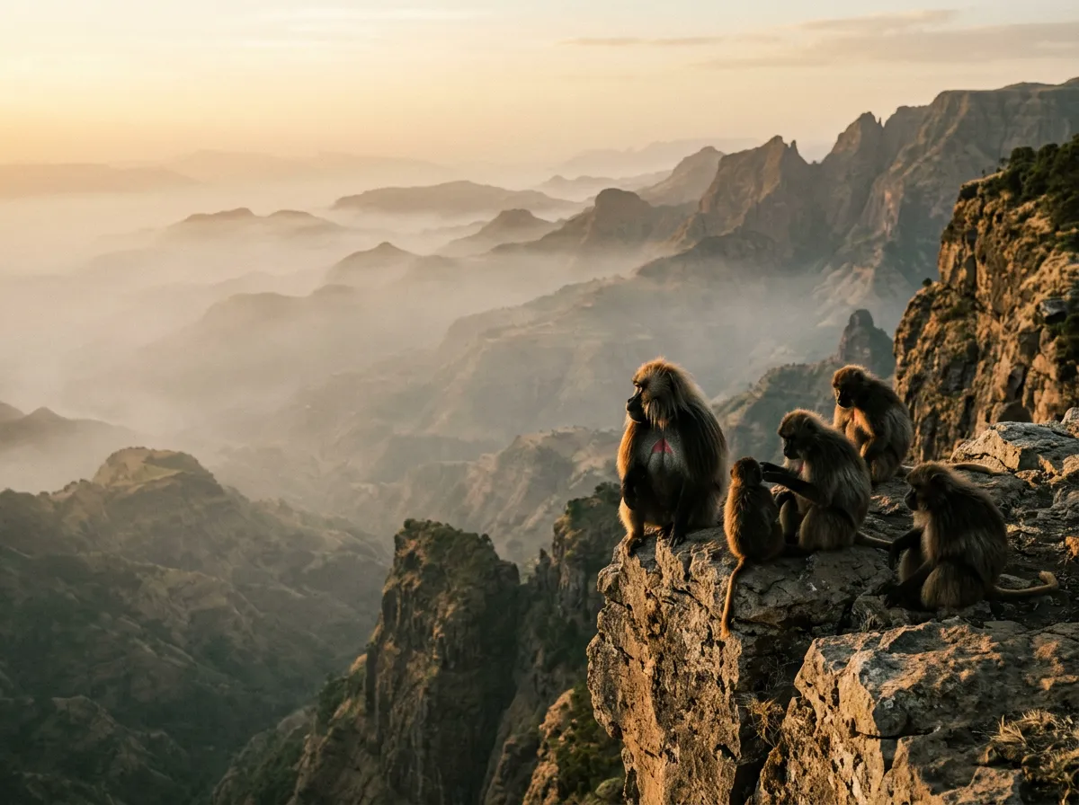
The gelada baboon was sitting on the road. Specifically, it was sitting on the outer edge of a road that was itself on the outer edge of a cliff approximately 800 metres above the valley floor. The baboon was holding a fistful of grass and eating it with the focused determination of someone enjoying lunch on a park bench, except the bench was a rock shelf with a drop that would kill anything that slipped off it, and the park was a mountain range that touches the stratosphere. Behind the baboon, another forty or fifty members of its troop were arranged along the cliff edge in various postures of grooming, feeding, and infant-wrangling. Behind them, nothing — air, haze, and the distant floor of a valley that could comfortably contain a European country.
We edged the Land Cruiser forward. The baboon glanced at us, pulled another tuft of grass from the road surface, and continued eating. It did not move. None of them moved. The gelada baboons of the Simien Mountains have been watching vehicles pass for decades, and they have correctly concluded that a Toyota Land Cruiser at walking pace is less interesting than a mouthful of highland grass. We drove through the troop at approximately 5 km/h, with baboons on both sides of the vehicle close enough to touch through the window. A juvenile climbed onto the bonnet, sat there for approximately ten seconds, looked at us through the windscreen with an expression of intense boredom, and jumped off. The whole encounter took about fifteen minutes and covered perhaps 200 metres of road.
The Simien Mountains are a UNESCO World Heritage Site in northern Ethiopia — a massif of volcanic rock that has been eroded over millions of years into a landscape of sheer escarpments, deep valleys, and pinnacles that rise above 4,000 metres. The mountains contain several of Africa’s highest peaks, including Ras Dashen at 4,550 metres, and support endemic wildlife found nowhere else on Earth: the gelada baboon, the Walia ibex, and the Ethiopian wolf. The road through the park — and “road” is a term of art rather than engineering — traverses this landscape on a shelf cut into the escarpment face, climbing from the gateway town of Debark at 2,800 metres to elevations above 4,400 metres before descending to the lowlands on the northern side.
We drove 180 km of this route over four days in November. Here is what happened.
Route overview
The circuit runs from Debark (the park’s gateway town and administrative centre) into the Simien Mountains National Park, traversing east along the escarpment before looping back via a highland plateau track. The route can be driven as an out-and-back from Debark or as a through-route continuing east toward the town of Mekane Berhan (though this extension requires additional days and a higher tolerance for uncertainty).
| Day | Section | Distance | Elevation | Key features |
|---|---|---|---|---|
| 1 | Debark to Sankaber camp | ~30 km | 2,800m → 3,200m | Park entrance, first escarpment views, Jinbar waterfall |
| 2 | Sankaber to Chenek camp | ~40 km | 3,200m → 3,600m | Imet Gogo viewpoint, gelada troops, cliff-edge driving |
| 3 | Chenek to Bwahit Pass area | ~50 km | 3,600m → 4,430m | Highest elevation, Ras Dashen visible, afro-alpine zone |
| 4 | Return to Debark | ~60 km | 4,430m → 2,800m | Descent via highland plateau, different route from ascent |
The tracks are mostly single-lane, unpaved, and cut into terrain that does not forgive inattention. The surface varies from compacted gravel to loose rock to mud (after rain), and the gradient changes are frequent and steep. Low-range is used regularly. The speed rarely exceeds 20 km/h and drops to 5-10 km/h on the cliff-edge sections.
Before you drive: Debark
The town
Debark (13.2333° N, 38.0333° E) is a small highland town 100 km north of Gondar. It is the administrative headquarters for the Simien Mountains National Park and the last place where logistics are possible. The town has fuel (fill completely — there is nothing in the park), basic supplies, a few hotels of varying quality, and the park office where you arrange your entry permit and mandatory scout.
Getting to Debark from Gondar: 100 km on a paved road that is mostly adequate. The drive takes 2-3 hours depending on truck traffic and livestock on the road. Gondar itself is reachable from Addis Ababa by road (700 km, 12-14 hours, a full day of driving) or by air (Ethiopian Airlines operates daily flights, 1 hour).
Park permits and the scout
The Simien Mountains National Park requires:
- Entry fee: $20 per person per day (as of 2026)
- Vehicle fee: $5 per day
- Mandatory armed scout: $15 per day
The scout is arranged at the park office in Debark. You do not choose your scout — one is assigned to you. The scout carries a rifle, speaks varying levels of English, and serves three functions: navigation (essential — the park tracks have junctions that are not signed), wildlife spotting (useful — they know where the gelada troops congregate), and security (largely symbolic, but the rifle is a deterrent against hyena at camp).
Our scout was a man named Tadesse who had worked in the park for twelve years and knew every rock, baboon, and blind corner on the road. His navigation was invaluable. His English was limited but functional. His rifle was old and appeared to be cleaned regularly, which was reassuring. He sat in the back seat and pointed left or right at junctions with a calm authority that made us feel like amateurs, which, compared to him, we were.
Acclimatization
Debark sits at 2,800 metres. If you are arriving from lowland Ethiopia (Addis at 2,400 metres, or from sea level), spend at least one night in Debark or Gondar before driving into the mountains. The circuit goes above 4,400 metres, and altitude sickness symptoms — headache, nausea, shortness of breath, poor sleep — begin for most people above 3,500 metres. The symptoms are manageable if you have acclimatized gradually and become dangerous if you have not.
Diamox (acetazolamide) can help with acclimatization. Consult your doctor before the trip. We used it and found it reduced symptoms at altitude, though it has side effects (tingling in the fingers, frequent urination, altered taste of carbonated drinks — the last of which is irrelevant in the Simien Mountains, where the beverage options are water and tea).
Day 1: Debark to Sankaber
The park entrance
The park gate is approximately 5 km east of Debark on a gravel road. Here your permits are checked, your scout boards the vehicle, and you receive a brief orientation that amounts to: drive slowly, do not exit the vehicle near wildlife, return before dark.
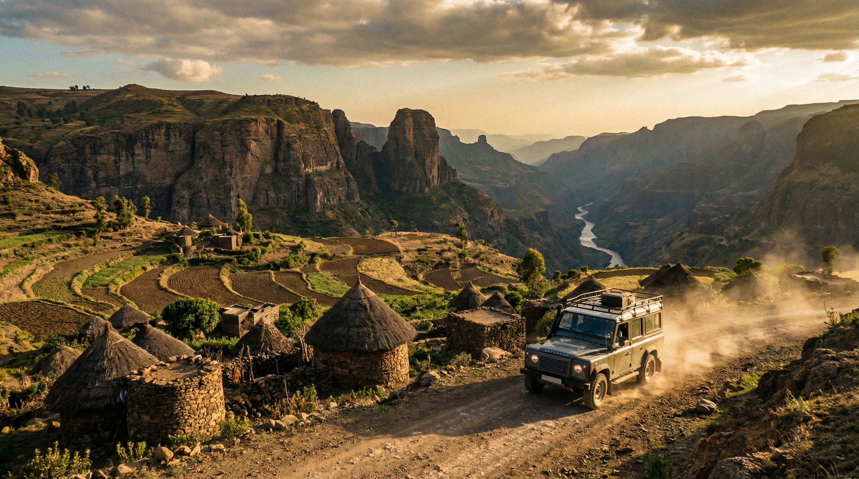
From the gate, the road climbs gradually through eucalyptus forest and agricultural terracing — the Simien Mountains are inhabited, and the lower slopes are cultivated with barley, wheat, and teff. The villages are made of stone and thatch, the fields are plowed by oxen, and the landscape looks like a medieval European illuminated manuscript brought to life at altitude.
First escarpment views
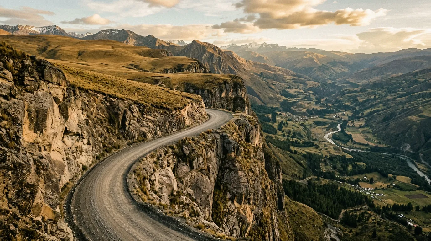
At approximately 3,000 metres, the agricultural landscape ends and the escarpment begins. The road emerges from a shallow valley onto a shelf cut into the cliff face, and the view opens — suddenly, completely, overwhelmingly — to reveal the depth of the Simien escarpment. The valley below is approximately 1,000 metres deep. The far wall is 10 km away. Between them, nothing but air and the occasional lammergeyer (bearded vulture) riding the thermals.
This is the first of many moments where the driving becomes secondary to the view. The road is adequate — gravel surface, enough width for a single vehicle — but the visual impact of driving along a cliff edge at this scale requires adjustment. We stopped. We got out (checking with Tadesse that this was safe). We stood at the edge and looked down. The vertigo was genuine.
Jinbar Waterfall
A short detour from the main track leads to a viewpoint overlooking Jinbar Waterfall — a 500-metre cascade that drops from the escarpment into the valley below. The waterfall is seasonal (most impressive during and just after the rains, October-November) and visible from a viewpoint that requires a 20-minute walk from the road. The walk is on a path, not a track — vehicles stay at the parking area.
Sankaber camp (13.2367° N, 38.0667° E)
Sankaber is the first designated camping area in the park, situated on a level area at approximately 3,200 metres. Facilities: flat ground, a long-drop toilet, and a view that belongs in a documentary. The camp overlooks the escarpment edge, and the sunset from Sankaber — watched from a camping chair at 3,200 metres while drinking tea brewed on a camp stove — is one of the finest we have experienced.
Night temperature: 3-8 degrees Celsius. Our sleeping bags (rated to minus 5) were adequate. The scout slept in a small building at the camp entrance. Hyenas called from the valley below but did not visit.
Day 2: Sankaber to Chenek
The gelada road
The track from Sankaber to Chenek is the signature section of the Simien circuit. It follows the escarpment edge for approximately 40 km, climbing gradually from 3,200 to 3,600 metres through terrain that alternates between cliff-edge shelf road, highland grassland, and stretches of afro-alpine vegetation.
The gelada baboons dominate this section. The troops — some numbering 300-400 individuals — occupy the cliff edges and the road surface itself. They are not aggressive, not afraid of vehicles, and not inclined to move unless physically displaced. Driving through a gelada troop is an exercise in patience and gentle horn work. They will move. Eventually.
The geladas are fascinating animals — the only grass-eating primates, with a social structure based on harems led by dominant males identifiable by their mane of hair and the red hourglass patch on their chest. The males display by flipping their lips back to reveal enormous canine teeth, which looks like a threat but is actually a social signal. Do not misinterpret it. They are communicating with each other, not with you.
Imet Gogo viewpoint
Imet Gogo (13.2450° N, 38.1500° E) is a promontory jutting from the escarpment with a sheer 1,000-metre drop on three sides. It is accessible from a track junction approximately 5 km from the main road — the scout will direct you to the parking area, from which a 45-minute walk reaches the viewpoint.
The viewpoint is not fenced, not railed, and not improved in any way. It is a rock platform with a 1,000-metre vertical drop. The sensation of standing on it — wind in your face, valley floor impossibly far below, escarpment walls receding into haze on both sides — produces a physical response that no amount of mountain experience can fully suppress. Our scout stood on the edge looking comfortable. We stood approximately three metres back looking less comfortable.
The view from Imet Gogo is the single most dramatic landscape we have seen from any road-accessible point in Africa.
Cliff-edge driving
The section between Imet Gogo and Chenek includes three stretches of cliff-edge road that require direct comment:
Width: The road is 2.5-3 metres wide. A Land Cruiser is approximately 1.85 metres wide. The margin is real but not generous.
Edge: The cliff edge is unguarded — no barrier, no berm, no curb. The road surface simply ends at the edge of a drop that varies from 300 to 800 metres.
Oncoming traffic: Rare but possible. If you meet an oncoming vehicle, one of you must reverse to a wider point. Reversing on a cliff-edge road is the most demanding driving task on this route. It requires a spotter (your scout or a passenger) standing behind the vehicle guiding you.
Our protocol: Slow speed (5-10 km/h). Windows open (to hear oncoming vehicles). Horn at blind corners (the standard Ethiopian practice). Eyes on the road surface, not the drop (easier said than done). The scout watched the outer edge and tapped the dashboard when we were too close. This happened more often than we would prefer to admit.
Chenek camp (13.2500° N, 38.2000° E)
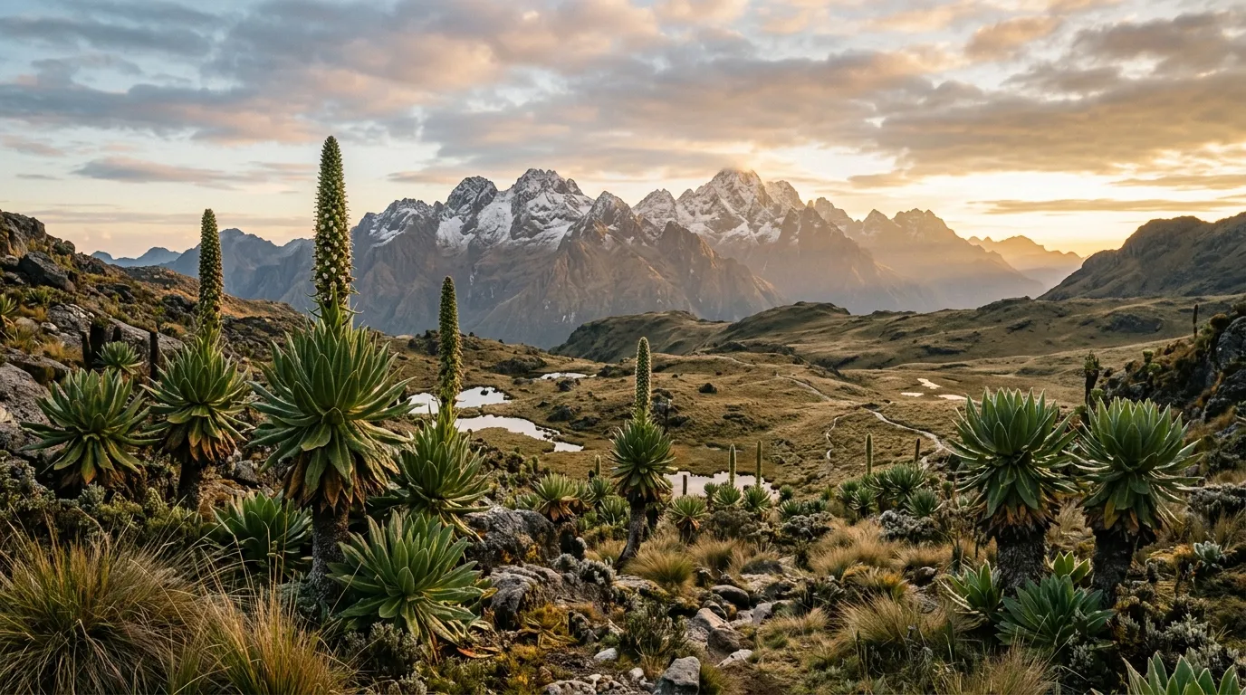
Chenek is the highest camp commonly used on the circuit, at approximately 3,600 metres. The setting is a flat area on the escarpment edge surrounded by giant lobelia plants — thick-stemmed rosettes that grow to 3 metres and look like they belong on a planet with different rules of botany. The lobelia are an afro-alpine species found only above 3,500 metres in East Africa, and the Chenek area contains the densest concentration on the circuit.
The Walia ibex — an endemic mountain goat found only in the Simien Mountains — is sometimes visible from Chenek camp. We did not see one, despite Tadesse’s efforts to locate them. The population is approximately 500 individuals, and they prefer the steepest cliff faces, which means binoculars and patience. The Ethiopian wolf is also present in the area — a red-furred canid that is Africa’s most endangered carnivore, with a total population of fewer than 500. We saw one at a distance of approximately 300 metres, trotting across the highland meadow above camp. It was smaller than expected, more fox-like than wolf-like, and moved with a determined pace that suggested rodent-hunting business.
Night temperature at Chenek: minus 2 to plus 3 degrees Celsius. Frost on the tent in the morning. The cold is real. Bring clothing and sleeping equipment rated for winter conditions.
Day 3: Chenek to the high point
The ascent above 4,000 metres
From Chenek, the track climbs steadily onto the highland plateau, leaving the escarpment behind and entering a landscape of afro-alpine moorland — low scrub, giant lobelia, heather trees bent horizontal by the wind, and an eerie openness that feels less like Africa and more like the Scottish Highlands transplanted to extreme altitude.
The altitude effects become noticeable above 3,800 metres. Breathing is labored on any exertion — getting out of the vehicle to check a tire feels like a cardiovascular workout. Thinking is slightly foggy. Appetite decreases. These are normal altitude responses and they pass, but they affect driving: reaction times are slower, judgment is marginally impaired, and the urge to rest is constant.
Bwahit Pass (4,430 metres)
The road crosses Bwahit Pass at approximately 4,430 metres — the highest point accessible by vehicle in the Simien range and one of the highest drivable passes in Africa. The pass itself is not dramatic — a broad saddle between peaks — but the altitude is. The air at 4,430 metres contains approximately 60 percent of the oxygen available at sea level. The vehicle’s engine notice this: power output drops, the diesel labors on inclines that would be trivial at lower elevation, and the turbo (if your vehicle has one) works harder.
From Bwahit Pass, Ras Dashen — at 4,550 metres the fourth-highest peak in Africa — is visible to the northeast. The peak itself is not spectacular (a broad, flat summit rather than a dramatic pinnacle), but knowing that you are looking at one of Africa’s highest points from a vehicle at 4,430 metres provides a satisfaction that relates to the improbability of the situation.
High-altitude driving notes
| Factor | Effect | Mitigation |
|---|---|---|
| Reduced engine power | ~15-20% power loss at 4,000m+ | Use low-range, accept slower speeds |
| Reduced braking efficiency | Brake fade on descents | Engine brake in low gear, avoid sustained braking |
| Driver altitude effects | Slowed reactions, fatigue | Shorter driving days, frequent stops |
| Cold (0°C or below at altitude) | Diesel gelling risk, cold start issues | Use winter-grade diesel if available, park facing east for morning sun |
| Wind | Gusts at exposed passes | Reduce speed, grip wheel firmly |
Day 4: Return to Debark
The descent
The return to Debark follows a different route from the ascent — a highland plateau track that descends gradually through agricultural land rather than along the escarpment. This route is less scenic than the ascent but significantly less nerve-inducing — the cliff-edge driving is absent, replaced by rolling highland terrain with long views across the plateau.
The surface is rougher on this section — less maintained than the main escarpment road, with rock protrusions, water erosion channels, and stretches of mud that persist in shadowed areas. Low-range is needed for some of the steeper descents, and the loose rock surface requires attention, but the exposure factor is zero. After three days of cliff-edge driving, the flat terrain feels like a holiday.
The descent takes approximately 4-5 hours for 60 km — slow, steady, and uneventful. We arrived in Debark by mid-afternoon, returned Tadesse to the park office, and checked into a hotel with the particular gratitude of people who have been sleeping at below-zero temperatures for three nights and are about to encounter a hot shower.
Equipment checklist
| Item | Required | Notes |
|---|---|---|
| Cold-weather sleeping bag (0°C or lower) | Yes | Chenek camp drops below freezing |
| Warm layers (fleece, windproof, hat, gloves) | Yes | Sub-zero wind chill at altitude |
| Extra fuel (20L minimum) | Yes | No fuel in park. 200+ km range needed. |
| Satellite communicator | Yes | No mobile coverage in the park |
| Basic recovery gear (tow strap, shovel) | Yes | Mud sections possible, especially after rain |
| Altitude medication (Diamox) | Recommended | Consult doctor. Useful above 3,500m. |
| Binoculars | Recommended | Walia ibex and Ethiopian wolf viewing |
| Camp stove and cooking equipment | Yes | No facilities at camps |
| Water purification | Recommended | Stream water available but untreated |
| First aid kit (comprehensive) | Yes | Nearest medical facility: Debark (basic) or Gondar (hospital) |
Fuel and water
We consumed approximately 30 litres of diesel over 180 km — lower consumption than expected, due to the consistently low speeds. The Land Cruiser’s 90-litre tank was more than sufficient. A vehicle with a 50-60 litre tank should carry 20 litres in jerry cans.
Water is available from streams in the park, but treatment (filter or purification tablets) is necessary. We carried 20 litres in containers and supplemented from filtered stream water. The camps do not have piped water.
Getting there and combining routes
Debark is the starting and ending point. From Gondar: 100 km, 2-3 hours on paved road. From Addis Ababa: flight to Gondar (1 hour, Ethiopian Airlines) then drive.
The Simien circuit combines naturally with the Danakil Approach Road — the Danakil is accessed from Mekelle, approximately 300 km east of Debark via Axum and Adwa. This creates a northern Ethiopia circuit: Gondar → Debark → Simien → Debark → Axum → Mekelle → Danakil → return. Allow 10-14 days for the combination.
For a broader Ethiopia itinerary, add the Omo Valley Tracks in the south — though this requires a full day of highway driving from the northern routes to Addis Ababa and then another day south to Jinka.
The honest summary
The Simien Mountains Circuit is the most dramatic mountain driving we have experienced in Africa. It is not the longest route (180 km over four days), not the most technically demanding (the surfaces are rough but not extreme), and not the most remote (the scout and the proximity to Debark provide a safety margin). What makes it extraordinary is the visual scale — the escarpment drops, the cliff-edge roads, the endemic wildlife occupying the road in front of you — combined with the altitude, which adds a physical dimension to the driving experience that lowland routes cannot replicate.
The cold is real. The altitude effects are real. The cliff edges are very real. None of these are reasons not to drive the route. They are the route.
Bring warm gear. Acclimatize properly. Trust your scout.