Jvari Pass to Mestia
Upper Svaneti is the kind of place that makes you question whether you have been travelling correctly up to this point. We drove in from Zugdidi — a lowland city in western Georgia where the temperature was 34 degrees and the roads were paved and boring — and within three hours we were at 2,379 metres, looking down at the Enguri gorge through clouds that sat below us like a second landscape, wondering how the medieval Svans had managed to build defensive towers at this elevation without machinery, paved roads, or any apparent interest in making life easier for themselves.
The answer, as far as we could tell, was stubbornness. Svaneti has been inhabited for at least five thousand years by people who chose to live in one of the most geographically hostile regions in the Caucasus rather than move somewhere warmer and flatter. The towers they built — stone, square, up to 25 metres tall — were designed to withstand clan warfare, blood feuds, and winters that last from October to May. They are still standing. The roads, which were designed to withstand nothing at all, are also still standing, though “standing” may be a generous description for what the old Jvari Pass road does in the rainy season.
This is a moderate route by Georgian mountain standards. The road is wider than the Tusheti road, the drops are shorter, and the traffic is lighter. But it is remote, the weather is unpredictable, and the 45 km from Mestia to Ushguli can be genuinely difficult after rain. We recommend a 4x4 for comfort and confidence, though we met a determined German couple in a Dacia Duster who had made it in dry conditions with nothing worse than a scraping noise they preferred not to investigate.
Route overview
The route runs from Zugdidi (elevation ~100 metres) to Mestia (1,500 metres) via Jvari Pass (2,379 metres), with an optional extension to Ushguli (2,200 metres). The total distance to Mestia is approximately 140 km. The Ushguli extension adds 45 km each way.
| Segment | Distance | Elevation | Terrain | Time |
|---|---|---|---|---|
| Zugdidi to Jvari tunnel junction | 55 km | 100m – 900m | Paved, some sections rough | 1.5 hrs |
| Old road over Jvari Pass | 30 km | 900m – 2,379m – 1,600m | Gravel switchbacks, exposed sections | 2 hrs |
| Jvari descent to Mestia | 55 km | 1,600m – 1,500m | Mix of paved and gravel, river valley | 1.5 hrs |
| Mestia to Ushguli (optional) | 45 km | 1,500m – 2,200m | Dirt, river crossings, rough gravel | 3 hrs |
The new Jvari tunnel, completed in recent years, allows you to bypass the pass entirely. This saves time and eliminates the most dramatic section of the drive. We took the old road. We suggest you do the same, unless weather makes it unsafe, in which case the tunnel is a reasonable concession to continued existence.
Zugdidi to Jvari Pass
The lowland approach (km 0–55)
The drive from Zugdidi is paved and unremarkable. The road follows the Enguri river valley upstream, passing through Jvari town — not to be confused with Jvari Pass, which is 40 km further and 2,000 metres higher. The scenery transitions from subtropical lowland (tea plantations, hazelnut orchards) to mountain forest as you gain elevation. The road quality deteriorates gradually, from smooth asphalt to rough asphalt to sections where the definition of “paved” becomes philosophical.
At the tunnel junction, you have a choice. Left goes through the new tunnel to the Enguri valley below the pass. Right goes up the old road to the pass itself. Right is the correct answer.
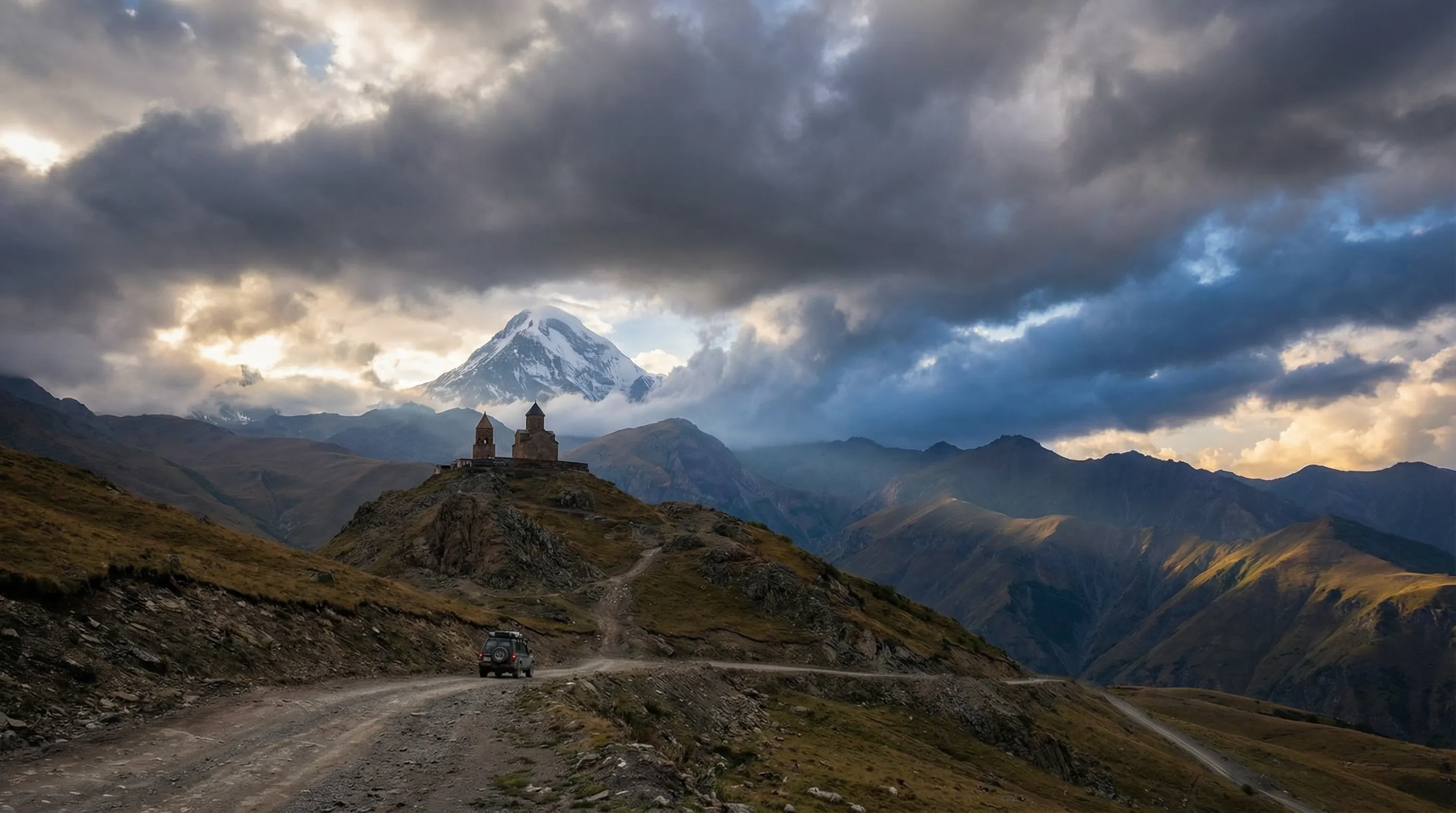
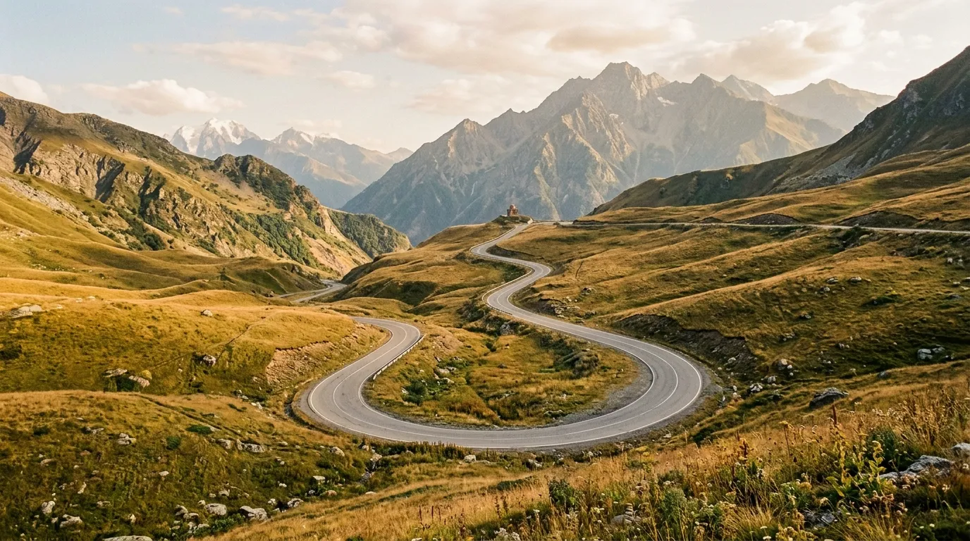
Jvari Pass: the old road (km 55–85)
The old Jvari Pass road climbs 1,500 metres in 20 km of switchbacks. The surface is compacted gravel, generally well-maintained but variable with weather. The road is wider than the Tusheti road — comfortably two lanes in most places — and there are intermittent guardrails on the more exposed sections. By Georgian mountain road standards, this is almost luxurious.
The climb passes through dense forest, then subalpine meadow, then bare rock and grass. Each vegetation zone lasts about ten minutes of driving. The views improve correspondingly: at treeline you can see the Enguri valley; above treeline you can see the western Caucasus ridge, snow-capped and improbably close; at the pass itself you can see both the valley you climbed from and the Svaneti valley you are descending into, separated by a knife-edge ridge that feels like the spine of the mountain range.
The pass is broad and windswept. There is usually a cluster of vehicles parked at the top — other people who chose the old road — and a view that justifies the gravel. On clear days, you can see Mount Ushba (4,710 metres), the double-peaked mountain that dominates the Svaneti skyline and that has killed more climbers than any other peak in the Caucasus. From the road, it looks beautiful and entirely innocent. It is not.
Descent to Mestia (km 85–140)
The descent from the pass follows the Mulkhura river valley. The road alternates between gravel and recently paved sections — the paving is ongoing and incremental, and by the time you read this, more of it may be finished than when we drove. The river valley is narrow and green, with waterfalls coming off the cliff faces and villages appearing at intervals that suggest a systematic approach to settlement that we found admirable.
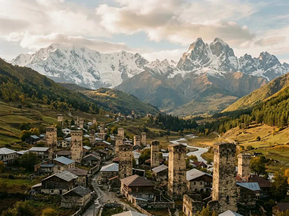
The Svan towers become visible about 30 km before Mestia. They appear first as isolated shapes on hillsides, then in clusters within villages, then in sufficient numbers that you realise this is not an architectural feature but a way of life. Every village has towers. Some villages have nothing but towers. The UNESCO designation covers the entire Upper Svaneti region, and it is earned.
Mestia itself is a small town on a river terrace, dominated by towers on three sides and mountains on the fourth. It has fuel (one station), guesthouses (many), restaurants (several, all serving the same excellent food), and a strikingly modern police station that looks like it was designed by someone who had seen too many architecture magazines and not enough medieval towers.
The Ushguli extension
Ushguli sits at 2,200 metres at the head of the Enguri valley, approximately 45 km from Mestia. It is generally cited as the highest continuously inhabited settlement in Europe, a claim that has been disputed by various other villages with varying degrees of credibility. What is not disputed is that it is high, remote, spectacular, and served by a road that requires either a 4x4 or an unreasonable amount of faith in a 2WD.
Road conditions: Mestia to Ushguli
The first 20 km from Mestia follow a gravel road through the Enguri valley. The surface is acceptable — compacted gravel with occasional potholes, passable for any vehicle with ground clearance. Then the road enters a series of river crossings.
We counted five fords between km 20 and km 40. In July, the water was ankle to shin-deep — no threat to a 4x4, manageable for a high-clearance 2WD with care. In June, after snowmelt, these crossings can be waist-deep and should not be attempted in a 2WD under any circumstances. Check locally in Mestia before setting out — the guesthouse owners all know the current conditions and will tell you honestly.
| Crossing | Approx. km | Depth (July) | Depth (June) | Notes |
|---|---|---|---|---|
| Ford 1 | km 22 | 15 cm | 40 cm | Gravel bed, straightforward |
| Ford 2 | km 27 | 20 cm | 50 cm | Rocky bed, slower approach needed |
| Ford 3 | km 31 | 25 cm | 60 cm+ | Deepest crossing, widest point |
| Ford 4 | km 36 | 15 cm | 35 cm | Narrow, fast-flowing |
| Ford 5 | km 39 | 10 cm | 30 cm | Shallow, good exit |
The last 5 km to Ushguli climbs through alpine meadow on a deteriorating track that becomes genuinely rough after rain. Ruts, loose rock, and mud sections are normal. In dry conditions: difficult but manageable. In wet conditions: bring a strap and hope you meet someone helpful.
Ushguli itself
The village is a cluster of medieval towers, stone houses, and a few guesthouses, spread across a hillside with Mount Shkhara (5,193 metres — the highest peak in Georgia) as a backdrop. The setting is extreme. The isolation is real. Ushguli is snowed in for five to six months of the year, and the road you drove to get here is their only vehicular connection to the outside world.
There is a small museum in the Lamaria church with medieval icons and Svan artefacts. There are guesthouses offering meals and beds. There is no fuel. There is no ATM. There is intermittent mobile coverage that works if you stand in the right field and hold your phone at the right angle, or so our host assured us.
We stayed one night. Dinner was pork stew, fresh bread, cheese, and chacha (Georgian grape brandy) of sufficient strength to explain why the Svans consider winter a manageable inconvenience. The view of Shkhara glacier from the guesthouse balcony at sunrise was worth the 45 km of river crossings and the increasingly philosophical definition of “road.”
Practical information
Vehicle selection
A 4x4 is recommended for the full route including Ushguli. For Mestia only via the old pass road, a high-clearance 2WD is possible in dry conditions — the pass road is gravel and the descent is increasingly paved. The Ushguli extension, however, has river crossings that strongly favour 4WD. We drove a Mitsubishi Pajero, which was comfortable for the pass and confident in the river crossings. A Jimny would also work. A regular car would not.
Fuel planning
| Location | Fuel available | Notes |
|---|---|---|
| Zugdidi | Yes, multiple stations | Fill up here |
| Jvari town | Yes, one station | Backup fill |
| Mestia | Yes, one station | Sometimes limited supply. Fill when you arrive. |
| Ushguli | No | Bring enough for the 90 km round trip from Mestia |
Timing
The pass road adds approximately 1.5 hours compared to the tunnel route. Budget a full day for Zugdidi to Mestia via the old road, with time for stops. Budget a second day for the Ushguli extension — it can be done as a day trip from Mestia, but it is long and tiring. If you stay overnight in Ushguli, the morning drive back to Mestia is shorter (you know the crossings) and the light is better.
Accommodation
Mestia has a range of guesthouses from 50 to 200 GEL per person per night (17-70 USD). Most include breakfast and dinner. The town has restaurants, a small market, and a surprisingly good bakery. Ushguli has five to ten guesthouses depending on the season, typically 80-120 GEL per person including meals. Book ahead in July and August.
Season
| Month | Pass road | Ushguli road | Notes |
|---|---|---|---|
| June (early) | Opening, mud likely | Difficult, high water | Expert only |
| June (late) – July | Good conditions | Crossings manageable | Best window |
| August | Dry, good surface | Easiest conditions | Warmest, driest |
| September | Cooling, possible rain | Deteriorating | Watch weather closely |
| October | May be snow on pass | Often closed by month end | End of season |
From here
The Tusheti road is the expert-level counterpart to this route — same country, same mountains, considerably more exposure and difficulty. The David Gareja desert loop offers an entirely different Georgia — semi-desert, cave monasteries, easy gravel — for those who want variety without another mountain pass. Return to the Georgia hub for the full country overview.
