Tusheti Road
The road to Tusheti begins with a lie. It starts in Pshaveli — a small town in the Pankisi Valley — as a reasonable gravel road that climbs gently through forest, and for the first ten kilometres you think: this is manageable. This is fine. Then the forest thins, the gravel becomes dirt, the dirt becomes mud, and the road narrows to a single lane carved into the side of a cliff with nothing between your right wheels and a 500-metre vertical drop except a thin layer of optimism and whatever grip your tires can find on wet rock.
We drove the Tusheti road in July, in a rented Suzuki Jimny with 32,000 km on the odometer and tires that the rental agency described as “new enough.” The drive took seven hours from Pshaveli to Omalo, including two stops to let oncoming vehicles pass (which means one vehicle reverses until a section wide enough for two appears), one stop to assess a waterfall crossing that had deposited fresh gravel across the track, and one stop that was purely psychological — a pause at a switchback where the exposure was so complete that we needed to sit with the engine off for five minutes before continuing.
This is not a road for everyone. We say that without condescension — it is a factual assessment of a route that has killed experienced drivers. But for those with the vehicle, the skill, and the nerve, it is also one of the finest mountain drives on Earth.
Route overview
The Tusheti road runs 72 km from Pshaveli (elevation approximately 600 metres) to Omalo (approximately 1,900 metres) via Abano Pass (2,926 metres). The road climbs for roughly 40 km to the pass, then descends for 32 km into the Tusheti valley. It is unpaved for its entire length.
| Segment | Distance | Elevation | Terrain | Time |
|---|---|---|---|---|
| Pshaveli to forest zone | 12 km | 600m – 1,200m | Gravel, moderate gradient | 45 min |
| Forest zone to treeline | 15 km | 1,200m – 2,200m | Dirt, switchbacks, mud sections | 1.5 hrs |
| Treeline to Abano Pass | 13 km | 2,200m – 2,926m | Exposed dirt, cliff edge, waterfall crossings | 2 hrs |
| Abano Pass to Omalo | 32 km | 2,926m – 1,900m | Dirt, switchbacks, river valley | 2.5 hrs |
The numbers are approximate. Speed on this road depends on conditions, traffic, and your personal relationship with the concept of a safety margin.
The climb: Pshaveli to Abano Pass
Lower forest section (km 0–12)
You leave Pshaveli heading north and immediately begin climbing through deciduous forest. The road here is wide enough for two vehicles in most places — enjoy this, because it will not last. The surface is compacted gravel with occasional mud patches where springs cross the track. Gradient is moderate. First gear is unnecessary. This is the section where you calibrate your tire pressure: we ran 1.6 bar (23 PSI) for the gravel sections, which proved about right for the full route.
The forest is beech and hornbeam, dense and green in summer. The canopy closes over the road in places, creating a tunnel effect that would be pleasant in other circumstances. Here it serves mainly to ensure you do not see the sky, which means you do not see the weather changing, which matters later.
Middle section: switchbacks and mud (km 12–27)
The road narrows. The forest transitions from broad-leaf to subalpine, and the switchbacks begin in earnest. Each hairpin is a blind corner, and each blind corner is a potential meeting with an oncoming vehicle — typically a Delica van loaded with supplies for the Tusheti villages, driven by someone who has done this route 200 times and has calibrated their risk tolerance accordingly.
The mud sections appear where springs and snowmelt cross the track. In June and early July, these can be substantial — axle-deep ruts filled with water of uncertain depth. Later in the season they dry to manageable slick patches. We encountered three significant mud crossings, two of which required low-range first gear and a degree of commitment. The third required a decision: left track or right track. We chose left. It was the wrong choice. We did not get stuck, but we spent fifteen seconds sliding sideways toward the downhill edge at walking pace, which is a very long fifteen seconds.
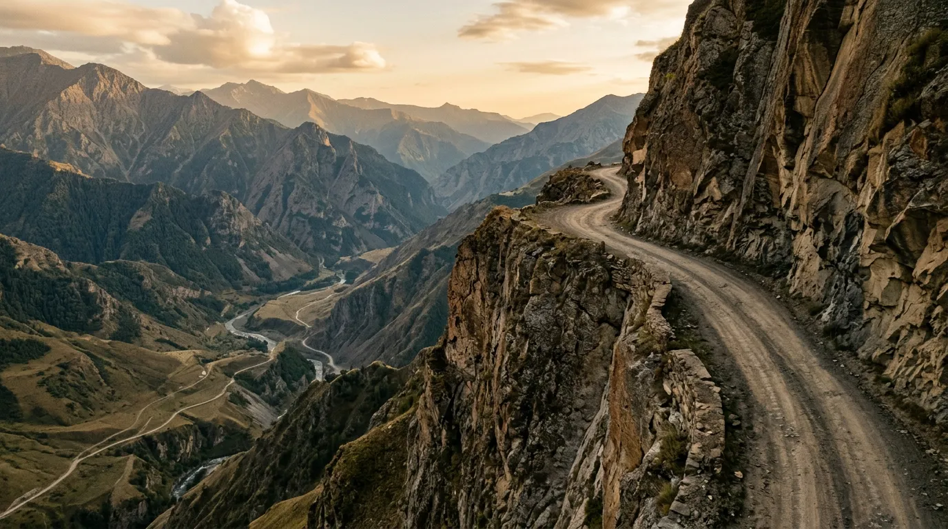
The exposed section: treeline to summit (km 27–40)
Above the treeline, the road becomes what it is famous for. The vegetation falls away. The switchbacks continue. And there is nothing between the road edge and the valley floor except air.
This is the section that appears in the photographs and the YouTube videos and the lists of “world’s most dangerous roads.” The photographs do not convey the scale. The valley floor is so far below that vehicles on the opposite mountainside look like insects. The road is cut into the cliff face at a width that accommodates one vehicle. In a few places, the outer edge has collapsed, narrowing the track further. There are no guardrails anywhere. There are no bollards. There are no reflective markers. There is dirt, rock, sky, and gravity.
We met two vehicles on this section: a supply truck and a UAZ van. The truck was coming uphill, which by convention means the downhill vehicle (us) reverses. We reversed for approximately 200 metres to a slightly wider point. The manoeuvre took ten minutes. We did not hit anything. We did not go over the edge. We did, however, develop a deep and lasting respect for the drivers who do this weekly.
The waterfall crossings are a specific feature of this section. Several waterfalls cascade directly across the road, depositing fresh gravel and creating pools of varying depth. These change daily. The one at approximately km 35 was running knee-deep when we crossed in July — not technically dangerous, but enough to splash the engine bay and test your nerve about what the water is hiding underneath.
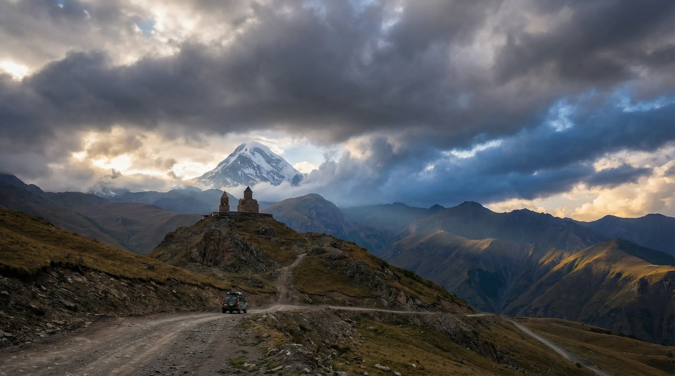
Abano Pass itself is an anticlimax in the best sense. You round a final switchback and the road levels onto a broad, windswept plateau at 2,926 metres. There is a small cairn. There is a view of the Tusheti valley spread below. The temperature dropped from 28 degrees Celsius at Pshaveli to 12 degrees at the summit. The wind was strong enough to make the Jimny’s doors difficult to open. We got out, looked at the view, and stood there for about ten minutes without speaking. The road earns this moment.
The descent: Abano Pass to Omalo
The descent into Tusheti is technically easier than the climb but psychologically no simpler — the switchbacks continue, the exposure continues, and you are now tired. The road drops from 2,926 metres to the valley floor at approximately 1,800 metres over 20 km of unrelenting hairpin turns, then follows the river valley for 12 km to Omalo.
The valley section is a relief. The road widens. There are trees. There are occasional stretches of gravel that feel almost civilised. The Tusheti river runs alongside, clear and fast. You will feel the tension leaving your shoulders somewhere around km 55, and you will realise that you have been gripping the steering wheel for the past five hours with a force that has left impressions on your palms.
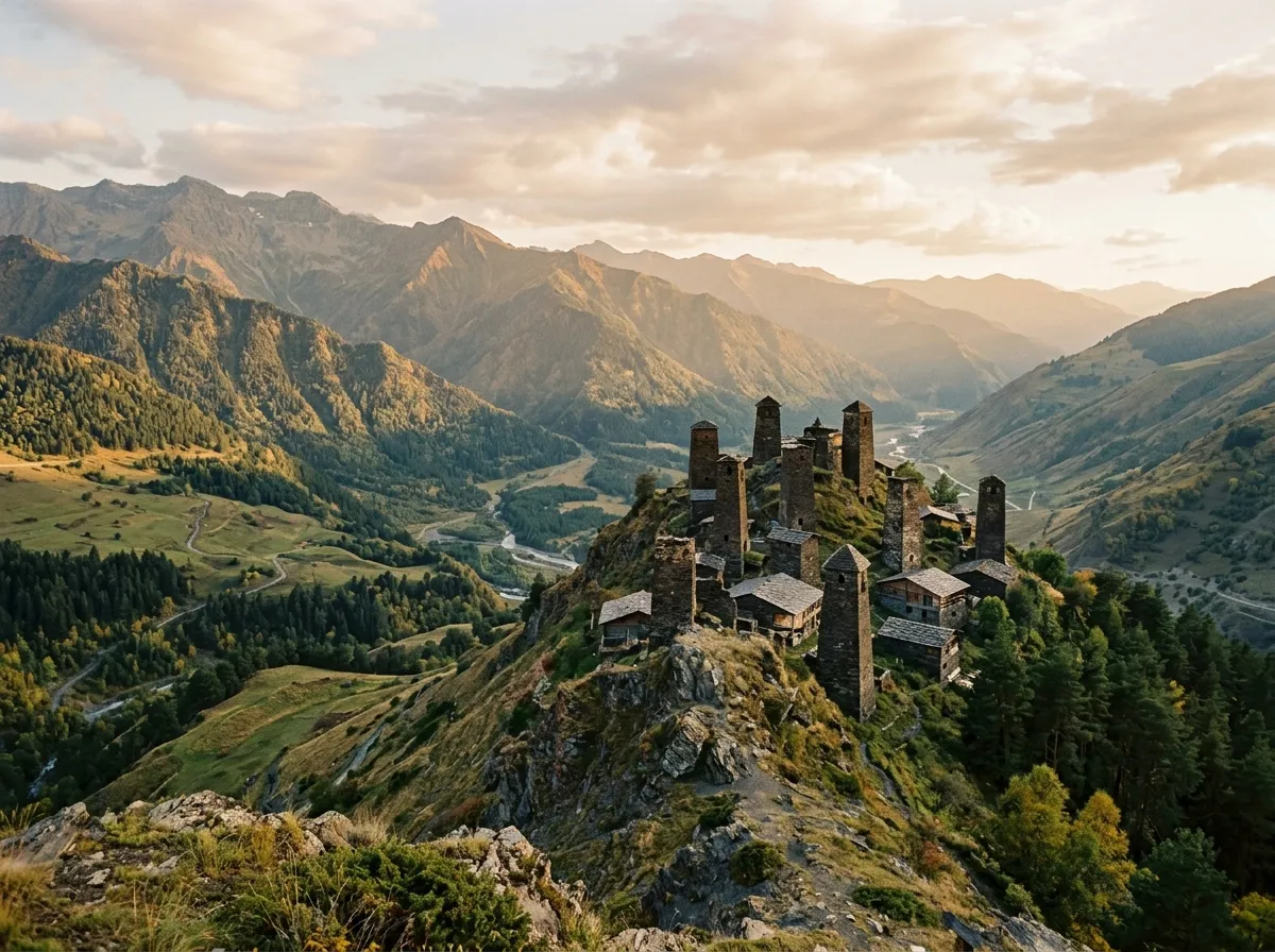
Omalo appears on a hillside above the valley — a cluster of medieval stone towers and newer guesthouses spread across a green ridge. The towers are Tushetian defensive architecture, built between the 12th and 18th centuries, and they look exactly like you imagine a medieval mountain fortress should look: square, stone, stern, and improbably sited on a hilltop that seems designed to discourage visitors.
Vehicle requirements
This route requires a 4x4 with low-range transfer case. This is not a recommendation — it is a prerequisite. The gradient, the surface conditions, and the recovery situations you may encounter all demand low-range capability. The Suzuki Jimny is the default choice and is ideal for the road width. A Mitsubishi Pajero or Toyota Prado will work but will feel large on the exposed sections. Anything wider than a Prado is a poor idea.
| Requirement | Detail |
|---|---|
| Drivetrain | 4x4 with low-range transfer case |
| Ground clearance | Minimum 200mm |
| Tires | All-terrain minimum, mud-terrain preferred |
| Tire pressure | 1.4–1.8 bar (20–26 PSI) depending on conditions |
| Fuel | Full tank at Alvani. No fuel in Tusheti. |
| Recovery gear | Tow strap minimum. Recovery boards helpful in mud season. |
Equipment checklist
| Item | Required | Notes |
|---|---|---|
| Full fuel tank + 10L jerry can | Yes | Nearest fuel is Alvani. Round trip without refuelling is ~150 km. |
| Recovery strap (rated 5+ tonnes) | Yes | For extracting yourself or others from mud sections |
| Warm clothing | Yes | Summit temperature can be 15°C+ lower than valley. Wind chill adds to this. |
| Water (2L per person minimum) | Yes | No reliable water sources on the road. River water in Tusheti is drinkable. |
| Offline maps (Maps.me or OsmAnd) | Yes | No mobile coverage above 1,500m |
| Tire pressure gauge + compressor | Recommended | For adjusting pressure between terrain types |
| First aid kit | Recommended | Nearest medical facility is Pshaveli (or Akhmeta by helicopter) |
Timing and logistics
Start before 7:00. This is not a suggestion. The afternoon brings clouds, reduced visibility, and — in the mountains — sudden rain that turns dirt to mud in minutes. You want to be over the pass and descending by early afternoon.
The drive from Tbilisi to Pshaveli takes approximately 3 hours on paved road. If you are starting from Tbilisi, either leave at 4:00 AM or spend the night in Pshaveli or Alvani. We recommend the overnight option. There are basic guesthouses in both towns, and starting the climb well-rested and in morning light is noticeably preferable to starting it fatigued at 10:00 AM.
In Omalo, guesthouses charge 60–100 GEL per person per night including meals (approximately 20–35 USD). The food is Georgian mountain cooking: khinkali, bread, cheese, fresh meat. It is substantial and good. Wine is available and locally made. We stayed at a guesthouse on the upper ridge with a view of the towers and the valley. The host drove the Tusheti road to collect supplies every two weeks. He considered it routine.
The return journey is the same road. There is no alternative route. Plan for the return to take slightly less time — you will know the difficult sections, and the psychological uncertainty will be reduced. The road is the road, however, and it does not get wider or less exposed on the second pass.
Season and conditions
The road opens when the snow melts off Abano Pass, typically mid-to-late June. It closes when the snow returns, typically late September to mid-October. The exact dates vary by year. There is no official announcement system — you ask locally, or you drive to the start and find out.
| Month | Conditions | Notes |
|---|---|---|
| June (early) | Often still closed | Snow on pass, mud in lower sections |
| June (late) | Opening. Heavy mud likely. | Waterfalls at peak flow. Expert only. |
| July | Best conditions | Mud drying, waterfalls moderate, long daylight |
| August | Good conditions | Driest surface, warmest temperatures |
| September | Deteriorating | Early snow possible, days shortening |
| October | Closing | Pass may close without warning |
Rain at any point during the season can reset conditions to June-level difficulty. If it has rained heavily in the previous 24 hours, wait a day. The road drains slowly above the treeline.
Safety
The Tusheti road is not a place where you can rely on rescue services. There is no mobile coverage for most of the route. There are no emergency phones. There is no regular patrol. If you break down or go off the road on the exposed section, your options are: fix it yourself, wait for another vehicle to pass (could be hours), or walk. A satellite communicator (Garmin inReach or similar) is not mandatory, but on this route, the argument against carrying one is weak.
Drive slowly. We averaged 10 km/h on the exposed section and never felt that we were going too slowly. The Jimny’s speedometer spent most of the climb reading between 8 and 15 km/h. This is not a road where speed has value. Every metre of visibility matters, every corner needs a horn signal, and every meeting with an oncoming vehicle needs time and patience and a clear plan for who reverses and where.
If the road feels beyond your skill level at any point, turn around. There is no shame in this. The road to Omalo will still be there next year, and arriving alive is the minimum acceptable outcome.
From here
Tusheti is the most dramatic of our Georgia routes, but the other two offer different rewards. The Jvari Pass to Mestia route shares the mountain driving character at a lower difficulty level and leads to the medieval towers of Svaneti. The David Gareja desert loop is a half-day drive through an entirely different landscape — semi-desert steppe and cave monasteries — accessible in a 2WD.