Askja Caldera Track
In the 1960s, NASA sent Apollo astronauts to the Askja caldera to practice walking on the moon. The training took place in the Odadahraun lava field — a 30 km expanse of black rock, volcanic sand, and terrain so barren and alien that it was deemed the closest available approximation to the lunar surface. Having driven through it, we can report that NASA’s location scouts were not exaggerating. The lava field is not metaphorically moonlike. It is the specific kind of desolate that makes you check, involuntarily, that you are still on Earth.
The Askja caldera sits at the end of the F88 and F910 — a chain of highland roads that lead from the Route 1 Ring Road near Myvatn into the volcanic interior of northeastern Iceland. The caldera is a collapsed volcanic crater containing Oskjuvatn, Iceland’s deepest lake at 217 metres, and Viti, a smaller crater lake whose water ranges from tepid to warm depending on the season and whose name translates, with Icelandic directness, as “Hell.” The drive to get there involves lava fields, black sand, and the Jokulsa a Fjollum river ford — a glacial crossing that is the single most technically demanding obstacle on any of our Iceland routes.
We drove to Askja and back in a single long day in late July. The round trip from the Ring Road is approximately 200 km, of which 100 km is the F-road section each way. We left the Myvatn area at 7:00 AM and returned at 8:00 PM, having spent 90 minutes at the caldera, 30 minutes assessing river crossings, and the remainder driving. The day was long. The caldera was worth it. The river crossing was the point where we most seriously questioned our recreational choices.
Route overview
The route splits into two F-road designations: the F88, which runs from the Ring Road south into the highlands, and the F910, which branches west to the Askja caldera. The junction is at Herdubreidarlindir, an oasis of relative green in the otherwise black desert.
| Segment | Distance | Elevation | Terrain | Time |
|---|---|---|---|---|
| Ring Road to F88 start | 5 km | 300m – 400m | Gravel, easy | 10 min |
| F88 start to Jokulsa river | 30 km | 400m – 500m | Gravel, lava field edges | 1 hr |
| Jokulsa a Fjollum ford | 0.2 km | 500m | River crossing — the crux | 15-30 min |
| Jokulsa to Herdubreidarlindir | 10 km | 500m – 550m | Gravel, volcanic sand | 30 min |
| Herdubreidarlindir to F910 junction | 5 km | 550m | Gravel | 15 min |
| F910 through Odadahraun lava field | 30 km | 550m – 900m | Lava track, black sand | 1.5 hrs |
| Askja car park to caldera (walk) | 2.5 km | 900m – 1,100m | Footpath, volcanic gravel | 45 min each way |
| Return (same route) | 100 km | — | Same terrain in reverse | 4 hrs |
Total driving time: approximately 8 hours. With caldera visit and river assessment: 10-12 hours.
Outbound: Ring Road to the river
The F88 approach (km 0–30)
The F88 begins with a barrier gate south of the Ring Road, marked with the standard F-road signage. The initial section is well-graded gravel — similar quality to the F35 Kjolur and entirely manageable. The terrain is open lava field, black and grey, with Herdubreid visible ahead: a table mountain that looks like someone sliced the top off a volcano with a bread knife, which is approximately what happened (a subglacial eruption beneath an ice cap, which constrained the lava flow horizontally and created a flat summit).
Herdubreid serves as your visual reference point for the first 30 km. You drive toward it. It does not appear to get closer. This is because it is 25 km away when you first see it and your depth perception in featureless terrain is unreliable. Eventually it does get closer, and the gravel road bends around its eastern flank toward the river.
The Jokulsa a Fjollum: the crux (km 30)
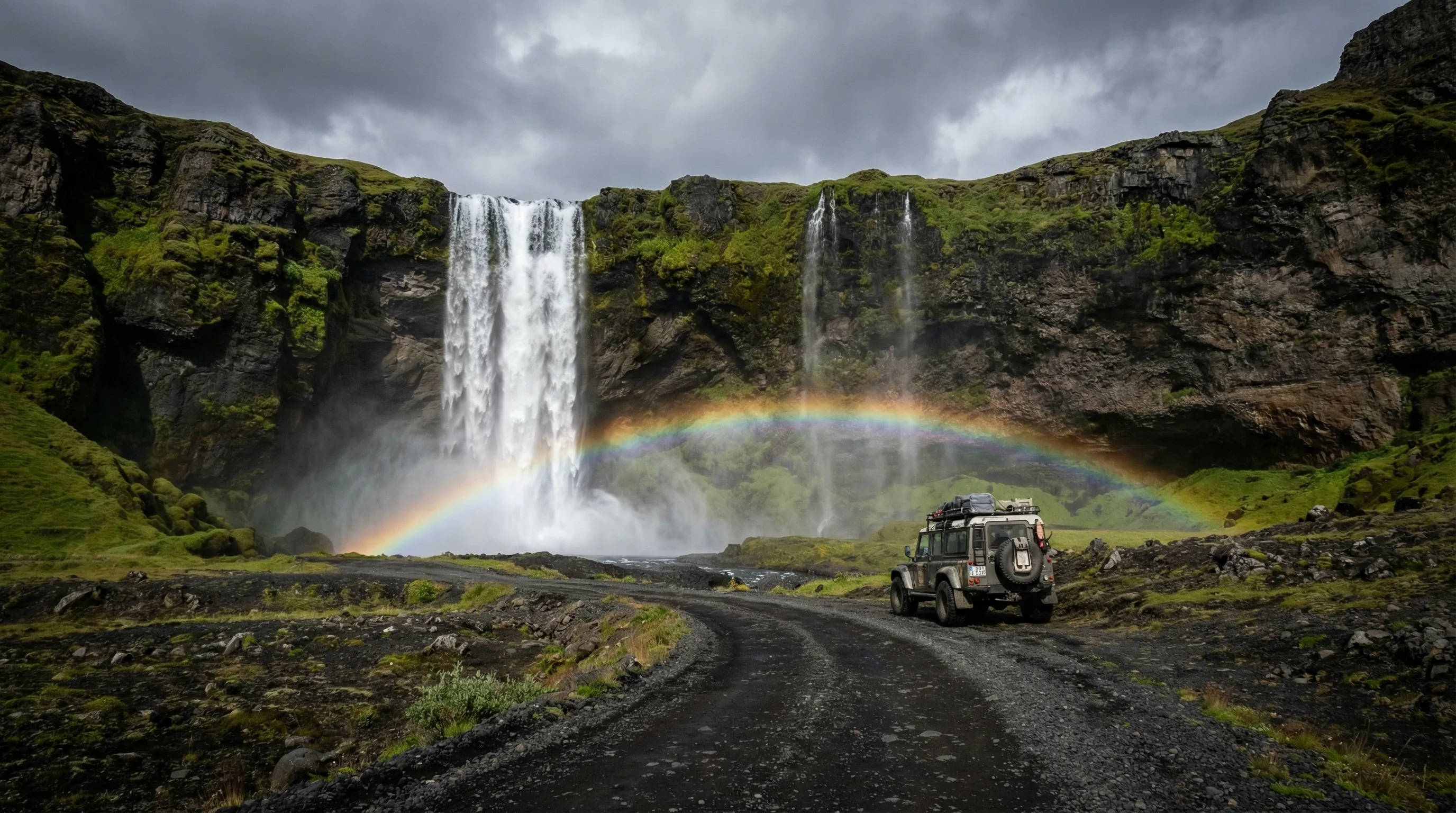
The Jokulsa a Fjollum is a glacial river carrying meltwater from the Vatnajokull ice cap to the Arctic Ocean. It crosses the F88 at a ford that is, depending on conditions, either the defining challenge of the route or the reason you turn around and drive home.
The ford is wide — 30 to 50 metres depending on the channel configuration. The bottom is mixed gravel and sand. The current is noticeable. The water temperature is approximately 2 degrees Celsius, which matters because you are about to wade into it in your waterproof boots to check the depth.
When we crossed in late July at approximately 10:00 AM, the deepest point was 55 cm. The bow wave from our Land Cruiser, travelling at walking pace in low-range first gear, pushed water above the bumper. The engine intake stayed clear. The crossing took about three minutes and felt considerably longer. On the far side, we stopped, got out, checked underneath the vehicle, and sat on a rock for five minutes while the adrenaline metabolised.
Assessment protocol for the Jokulsa ford:
- Stop well back from the water. Walk downstream 50 metres to get a perspective on the full crossing width.
- Enter the water on foot. Use a walking pole or stick for stability — the current is real.
- Walk the full crossing width. Map the deepest point. Check the bottom composition at the deepest point.
- If the deepest point is below your knee (approximately 45 cm): cross in the vehicle.
- If the deepest point is between knee and mid-thigh (45-60 cm): assess your vehicle’s capability honestly.
- If the deepest point is above mid-thigh (60 cm+): do not cross. Return to the Ring Road.
These are not arbitrary thresholds. A 4x4 without a snorkel has an engine air intake at approximately 60-80 cm above ground level, depending on the model. Water above the intake means a hydrolocked engine, which means a very expensive helicopter extraction from the Icelandic interior.
Depth variation table:
| Time of day | Approximate depth (July) | Notes |
|---|---|---|
| 6:00 – 9:00 AM | 35 – 45 cm | Overnight cooling, minimum meltwater |
| 10:00 AM – 1:00 PM | 45 – 55 cm | Rising as glacier melt begins |
| 2:00 – 6:00 PM | 55 – 70 cm+ | Peak meltwater, maximum depth |
| After rain | Add 10-20 cm | Runoff from rain and increased melt |
Cross in the morning. This is not optional guidance.
Herdubreidarlindir to Askja
The oasis (km 40-45)
Herdubreidarlindir, on the far side of the river, is a relative oasis — a flat area with some vegetation, a mountain hut (bookable through fi.is), and a campsite. “Relative oasis” means there is grass. After 30 km of lava field, grass is remarkable. The hut is a useful rest point and provides the last reliable toilet before the caldera. Water from the stream is drinkable.
The Odadahraun lava field (km 45-80)
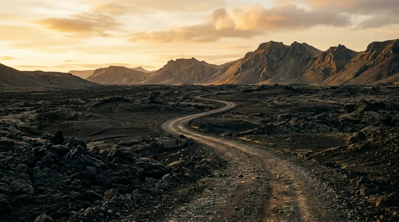
From the F88/F910 junction, the route turns west into the Odadahraun — the Lava of Evil Deeds, named with Icelandic precision for the outlaws who once hid in its fissures. This is the section that NASA used for Apollo training, and driving through it you understand why.
The lava field is 30 km of shattered black rock, volcanic sand, and a track that is less “road” and more “suggested line through rubble.” The surface alternates between compacted sand (reasonable), loose sand (slower), and sections where the track crosses lava flows directly (very slow, very careful). The lava has edges. The edges are sharp. Tires do not appreciate sharp lava edges, and a puncture here is a serious inconvenience.
Speed in the lava field: 15-25 km/h. No faster. The surface is uneven, the track is narrow, and the consequences of a wrong line include sharp lava contacting body panels, axles, or tires. We picked our way through at a pace that felt impatient at the time and, in retrospect, was exactly correct.
The terrain climbs gradually from 550 to 900 metres as you approach the caldera. The lava gives way to volcanic ash and gravel. A final stretch of black sand leads to the Askja car park — a flat area of volcanic gravel with space for 20-30 vehicles, a basic toilet structure, and a signboard explaining the geology.
The caldera
The walk in (2.5 km, 45 min)
From the car park, a marked footpath leads over the caldera rim and down to the lakes. The walk is 2.5 km each way, across volcanic gravel and snow patches (present even in July), with a descent into the caldera that is moderately steep. The path is well-marked with stakes. The footing is loose gravel. Walking boots are the correct footwear. Trainers will work but will fill with volcanic grit.
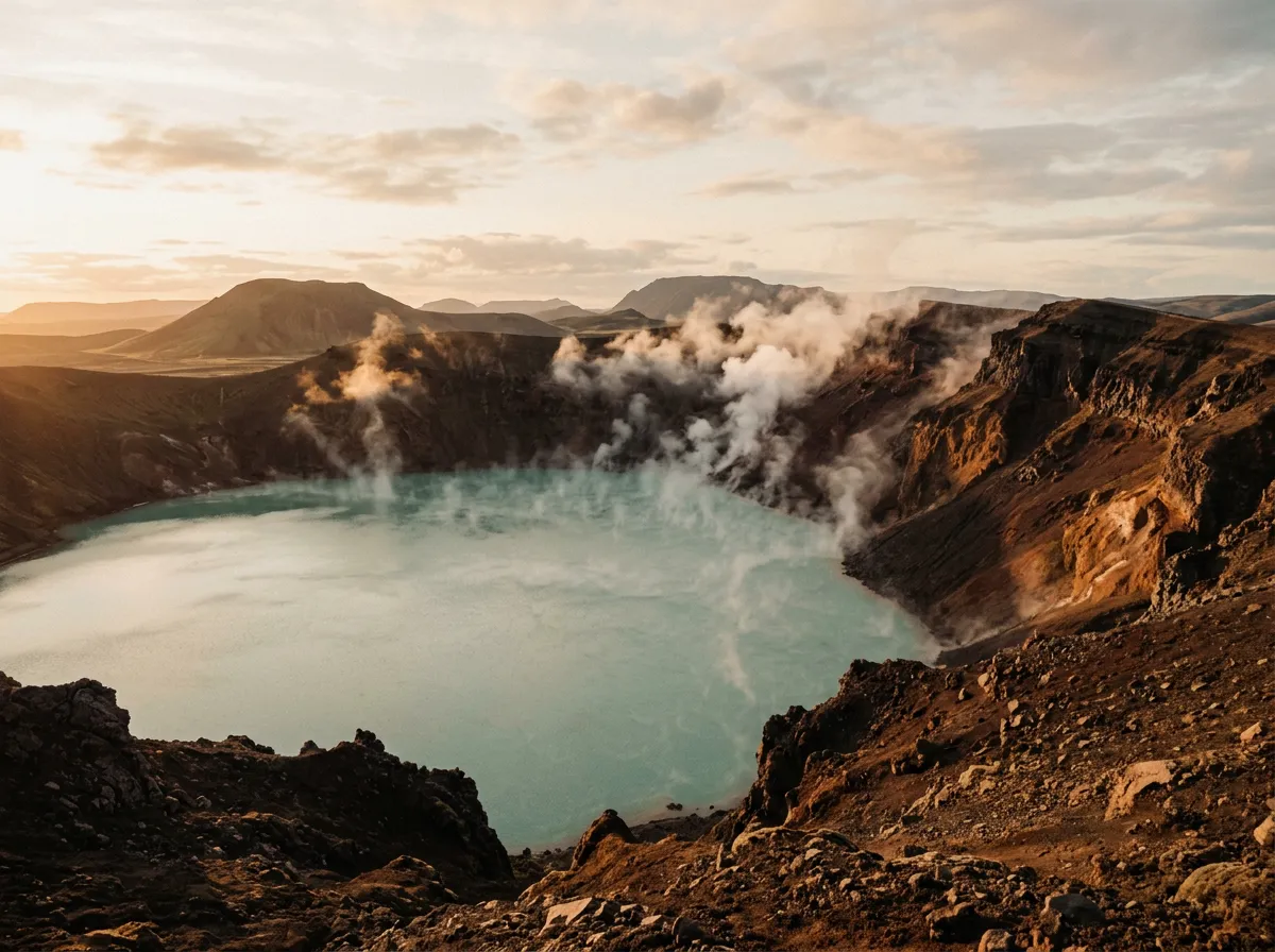
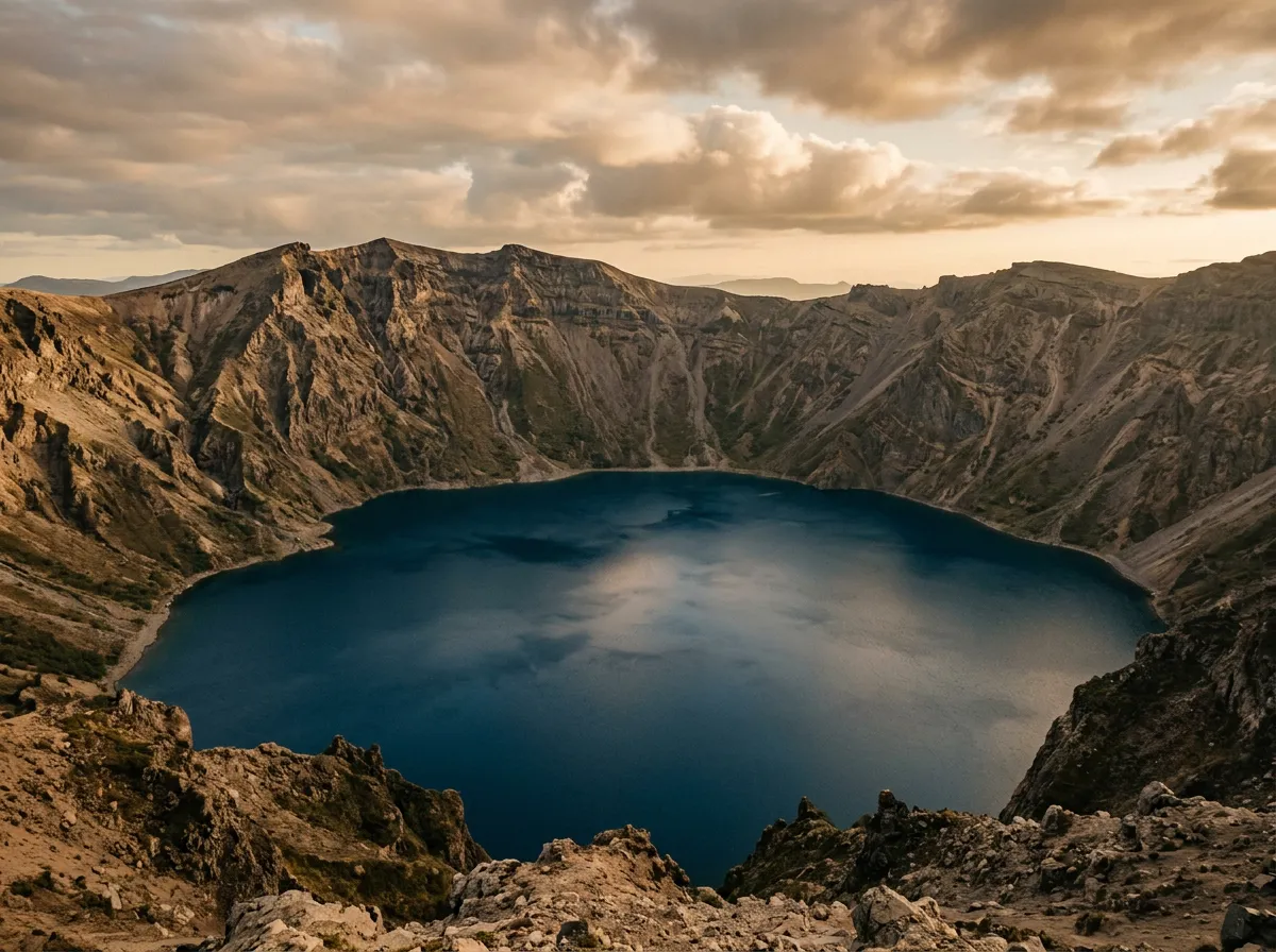
The caldera reveals itself gradually. You climb the rim and see first the far wall — the opposite side of the crater, perhaps 5 km away — and then the lake. Oskjuvatn fills the caldera floor: a deep, dark, cold lake formed by a massive eruption in 1875 that deposited ash across Scandinavia and caused a measurable drop in global temperature. The lake is 217 metres deep. It did not exist before the eruption. It is a startlingly young geological feature, and standing on the rim, you can see the raw, unweathered rock of the caldera walls and understand that this landscape is still being assembled.
Viti crater
Viti is a smaller crater on the edge of the main caldera, containing a lake of milky blue-green water that ranges in temperature from cold to warm depending on geothermal activity and season. The word Viti means “Hell” in Icelandic, which was more accurate before the geothermal activity diminished somewhat and the water cooled from “actively unpleasant” to “intermittently lukewarm.”
You can swim in Viti. Many people do. The descent to the water involves a steep, loose path down the inner crater wall — approximately 30 metres of slippery volcanic gravel that is more controlled slide than walk. The water, when we visited, was approximately 22 degrees Celsius — warm by Icelandic standards, cool by any other. It smelled of sulphur. The colour was otherworldly. The experience of swimming inside a volcanic crater, looking up at the walls of the crater and the sky above, is one of the more surreal things we have done on any trip.
A note on conditions: Viti’s temperature varies year to year and month to month. Some visitors report warm water (25-30 degrees). Others report cold water (10-15 degrees). The geothermal system beneath the crater fluctuates. If the water is cold when you arrive, you can still swim, but “swim” may become “brief immersion followed by rapid exit.”
The return
The return drive follows the same route. You know the terrain, you know the river crossing, and you know the lava field. This makes the return faster — we shaved 90 minutes off the outbound time — but it does not make it easy. The river crossing is the same crossing, and if you are returning in the afternoon, the water will be deeper than when you crossed in the morning. Factor this into your timing.
If the river is significantly higher on your return, you have two options: cross carefully (if it is still within your vehicle’s capability) or wait. Water levels drop after sunset as the glacier cools and meltwater decreases. In extreme cases, this might mean waiting two to three hours. This is preferable to drowning your engine.
Practical information
Vehicle requirements
| Requirement | Detail |
|---|---|
| Drivetrain | 4x4 with low-range essential |
| Ground clearance | Minimum 210mm. More preferred for lava sections. |
| Tires | All-terrain with good tread depth. Lava is sharp. |
| Snorkel | Strongly recommended for the Jokulsa ford |
| River fording depth | Vehicle should handle 60 cm |
| Fuel capacity | Full tank + 10L jerry can recommended |
This is a route for a full-size 4x4. We do not recommend small 4x4s (Jimny, Duster) for the river crossing or the lava field. The Land Cruiser Prado we used was appropriate. A modified Land Cruiser 70 or 76 series would be ideal. The vehicle rental premium for a capable 4x4 in Iceland is justified on this route.
Fuel
| Point | Fuel | Notes |
|---|---|---|
| Myvatn area (Route 1) | Yes | Fill completely. Last fuel. |
| Entire F88/F910 route | No | Nothing. |
| Return to Myvatn | Yes | Same station |
The round trip from the Ring Road is approximately 200 km of highland driving. Budget 20+ litres per 100 km for highland consumption. A vehicle with a 70L tank should have sufficient range. Smaller tanks: carry a jerry can.
Timing and season
The F88/F910 to Askja opens approximately early to mid July and closes in late August. That is a window of about six weeks. Some years it is shorter. Check road.is daily in the days leading up to your planned drive.
| Schedule | Time | Notes |
|---|---|---|
| Leave Myvatn | 7:00 AM | Earliest reasonable start |
| Reach Jokulsa ford | 8:30 AM | Low water crossing |
| Reach Askja car park | 11:00 AM | Begin walk to caldera |
| At caldera | 11:45 AM – 1:15 PM | Explore, swim Viti |
| Return to car park | 2:00 PM | Begin return drive |
| Jokulsa ford (return) | 5:00 PM | Water higher than morning — assess |
| Return to Ring Road | 6:30 PM | Refuel, eat |
This is a compressed schedule for a long but achievable day. Adding overnight stays — at Herdubreidarlindir outbound, at the Askja area (tent only, no hut), or at Herdubreidarlindir on return — transforms this into a more comfortable two-day trip.
What to bring
| Item | Notes |
|---|---|
| Waterproof boots (knee-high) | River assessment. Non-negotiable. |
| Swimsuit and towel | Viti crater. Worth the weight. |
| Warm layers + windproof jacket | 900m elevation, wind, possible rain |
| Walking boots | Caldera walk is 5 km return on loose gravel |
| Food and water (full day) | No services anywhere on the route |
| Tow strap | For river recovery if needed |
| Satellite communicator | No mobile coverage. Recommended. |
| Spare tire (and knowledge to change it) | Lava field puncture is a real possibility |
The alternative: bus tours
For those without a suitable vehicle or river-fording experience, commercial bus tours run from Myvatn to Askja during the open season. The buses are modified Super Jeeps driven by experienced locals who ford the Jokulsa daily. This removes the driving challenge entirely and delivers you to the caldera with time to explore. We have no criticism of this approach. The caldera is the destination, and how you get there is a matter of preference and capability.
From here
Askja is the most committed of our Iceland routes. If you have driven it, you have experienced the full range of what Icelandic highland driving demands — river fords, lava fields, volcanic sand, and the specific quality of isolation that the interior offers. The F26 Sprengisandur covers a longer distance through the black desert without the deep river crossings or lava sections of Askja. The F35 Kjolur is the accessible alternative — same volcanic landscape, no river fords, and a hot pot at the halfway point. Return to the Iceland hub for the full country overview.