F35 Kjolur Highland Route
We tell people to start with Kjolur. We tell them this not because it is easy — by any non-Icelandic standard it is a full day of demanding gravel driving through terrain that looks like a rendering error in a geology simulation — but because it is the least likely to kill you on your first attempt at Iceland’s highland interior. There are no river fords. This single fact places Kjolur in a different category from every other F-road of comparable length, and it is the reason we recommend it as the entry point for highland driving.
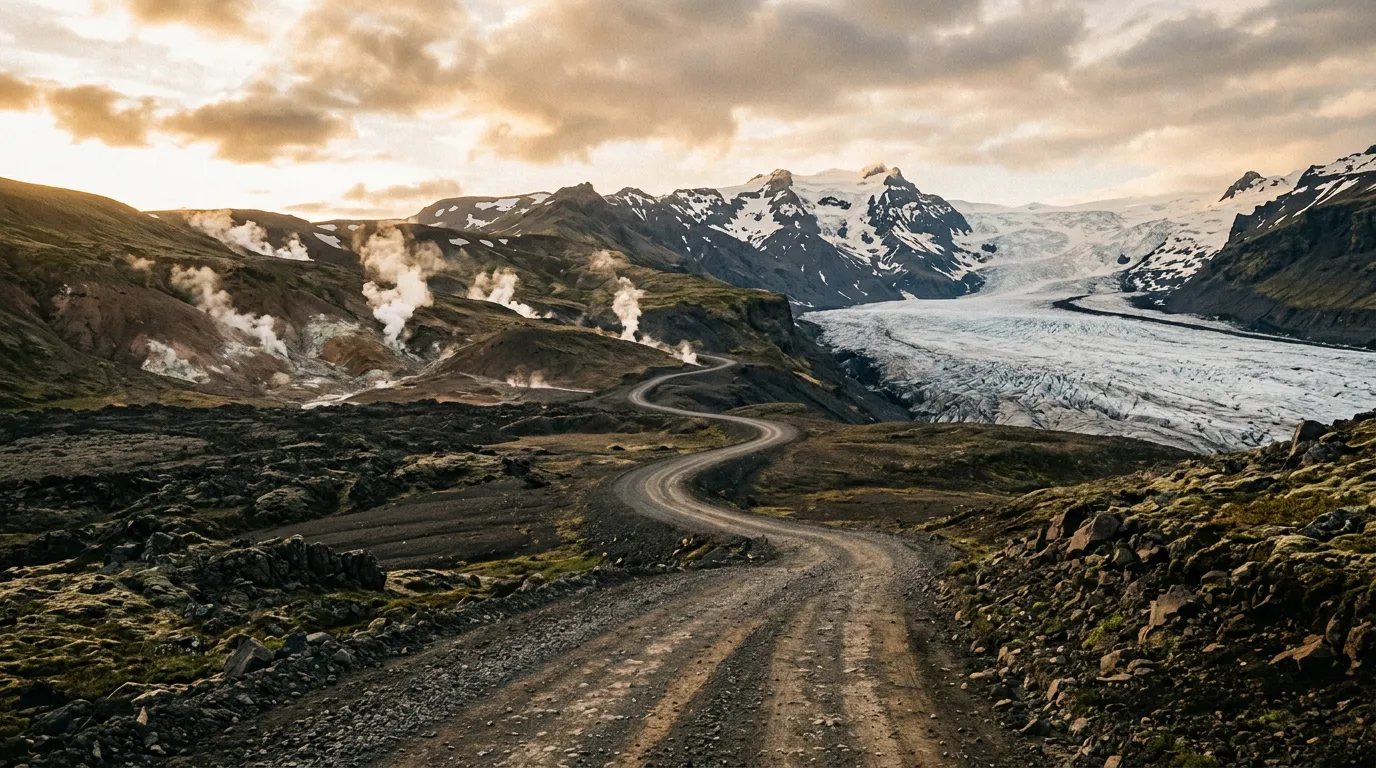
The route runs 200 km between Gullfoss, the waterfall that anchors the Golden Circle tourist route, and Blonduos, a small town on the north coast. Between these two points of civilisation lies approximately seven hours of volcanic desert, geothermal steam vents, gravel corrugations, and a corridor between two glaciers that makes you feel as though you are driving between walls of ice. At the midpoint, the Hveravellir geothermal area offers hot springs, a mountain hut, and the surreal experience of sitting in a natural hot pot surrounded by desert and steam while your vehicle cools its brakes in the car park.
We drove Kjolur in early July, in a rented Toyota Land Cruiser Prado with winter tires (Iceland rents vehicles with winter tires year-round, and in the highlands this is sensible even in summer). The drive took eight hours including a two-hour stop at Hveravellir, during which we soaked in the hot pot, ate sandwiches, and watched clouds form and dissolve on the Langjokull glacier as if the ice cap were breathing.
Route overview
The F35 runs roughly north-south through the highland interior, passing between the Langjokull glacier (to the west) and the Hofsjokull glacier (to the east). The highest point is approximately 700 metres, which by Icelandic highland standards is modest — this is a plateau route, not a mountain pass.
| Segment | Distance | Elevation | Terrain | Time |
|---|---|---|---|---|
| Gullfoss area to F35 junction | 15 km | 400m – 500m | Paved → gravel transition | 20 min |
| F35 junction to Hvitarvatn lake | 50 km | 500m – 650m | Gravel, corrugated sections | 1.5 hrs |
| Hvitarvatn to Hveravellir | 40 km | 650m – 650m | Gravel, volcanic sand | 1 hr |
| Hveravellir to highland plateau | 50 km | 650m – 700m | Gravel, exposed plateau | 1.5 hrs |
| Highland plateau to F35 north end | 30 km | 700m – 500m | Gravel, descending | 45 min |
| F35 north end to Blonduos | 15 km | 500m – 20m | Gravel → paved transition | 20 min |
Total driving time: approximately 5.5 hours without stops. With Hveravellir and photography stops, budget 7–8 hours.
The southern approach: Gullfoss to Hvitarvatn
Leaving the Golden Circle (km 0–15)
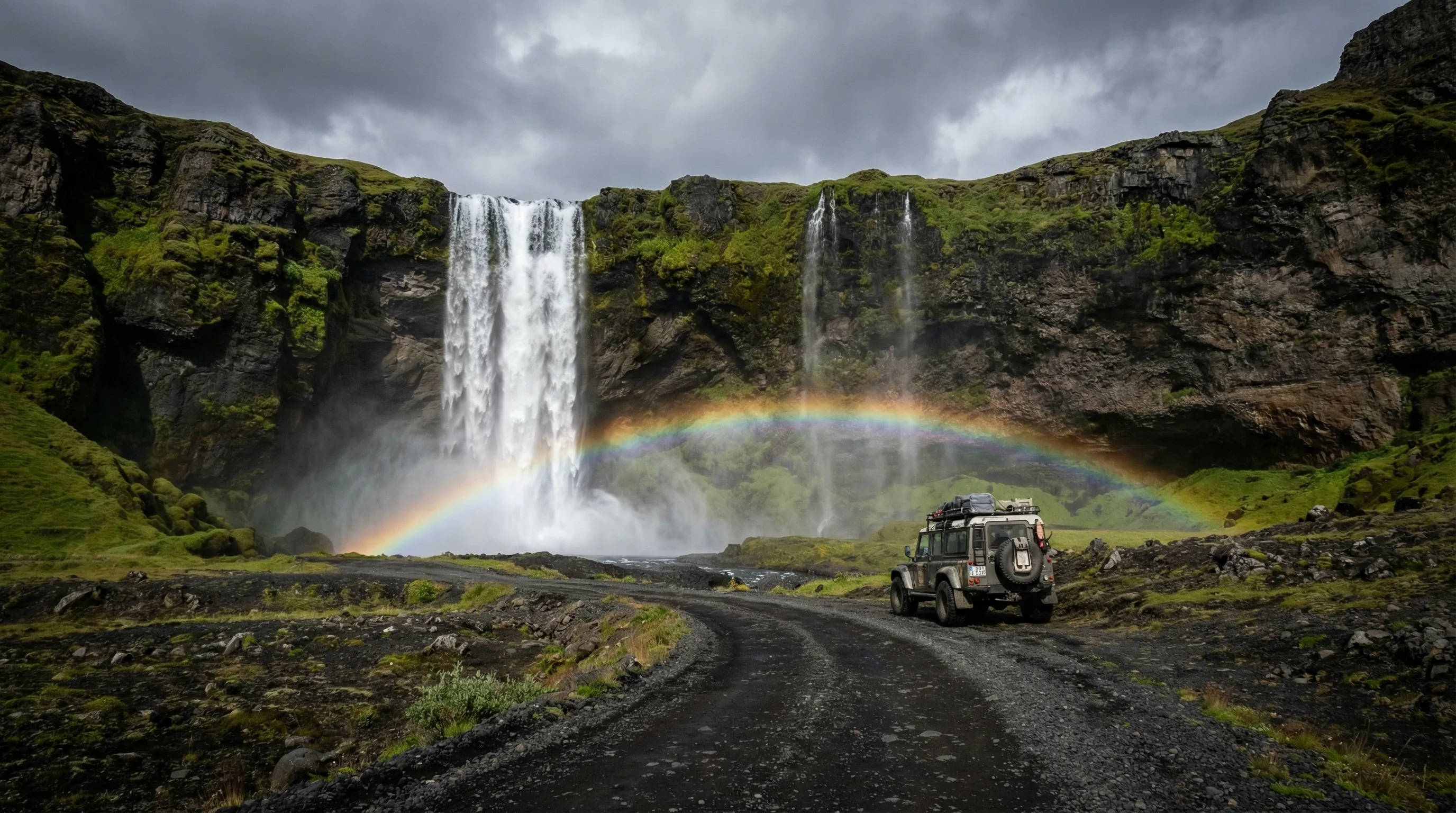
You leave the tourist masses at Gullfoss and drive north on a paved road that becomes gravel within a few kilometres. The transition is not dramatic — the asphalt thins, develops patches, and eventually concedes to compacted gravel. The landscape, however, changes abruptly. The green farmland of the lowlands disappears. The terrain becomes brown, then grey, then something close to no colour at all — a volcanic ash desert patched with moss and lichen and crossed by braided glacial streams.
The F35 designation begins at a junction marked with the standard Icelandic F-road sign: a yellow diamond with the route number. There may be a barrier if the road is closed. If the barrier is open, the road is open. If the barrier is closed, do not drive around it. This seems obvious, but the Icelandic rescue services report multiple instances per season of tourists dismantling barriers and driving onto closed roads. The barriers exist because the road is impassable. The road does not care about your schedule.
The glacier corridor (km 15–65)
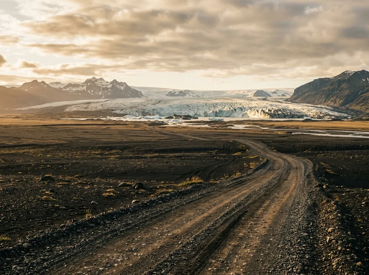
Once on the F35, you are between the glaciers. Langjokull is to your left — Iceland’s second-largest ice cap, visible as a white mass on the western horizon that grows larger as you drive north. Hofsjokull is to your right, initially less visible but gradually emerging as you gain elevation. Driving between two glaciers sounds like a description from a fantasy novel, and in practice it feels that way too. The glaciers are not close — they are 20 to 30 km away on each side — but on a clear day they dominate the landscape in a way that makes the volcanic desert between them feel like a corridor.
The road surface in this section is variable. Compacted gravel alternates with corrugated sections that vibrate the vehicle at frequencies your spine will remember. The standard advice for corrugated gravel is to either go very slow (painful but safe) or increase speed until you skim over the ridges (faster but less controlled). We alternated between the two approaches and found that 40–50 km/h was the threshold where the corrugations smoothed out. Your vehicle and your tolerance may differ.
Hvitarvatn lake appears at approximately km 50 — a glacial lake at the edge of Langjokull, milky blue-green with icebergs calving from the glacier tongue. There is a parking area and a short walk to the lake shore. The icebergs are smaller than you expect from photographs but no less striking in person. The colour of the water is not enhanced by any filter — glacial flour in suspension does this to light, and it is genuinely that blue.
Hveravellir: the midpoint
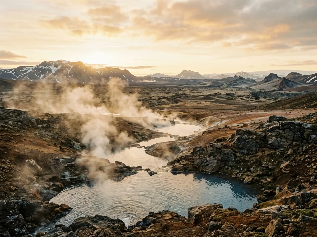
Hveravellir is the reason many people drive Kjolur, and it is worth the gravel. The geothermal area sits at approximately 650 metres elevation in the middle of the highland desert — a cluster of hot springs, steam vents, and silica formations surrounded by nothing in every direction. There is a mountain hut (bookable through fi.is), a campsite, a small visitor facility, and a hot pot.
The hot pot is a natural geothermal pool, maintained at approximately 38–40 degrees Celsius, open to anyone. You change in the hut facilities, walk to the pool, and sit in hot water while looking at a volcanic desert and a glacier and a sky that is doing something meteorologically interesting. We stayed for two hours. The water smelled faintly of sulphur. The wind was 30 km/h and the air temperature was 8 degrees. We did not want to get out.
The geothermal area itself is a short walk from the hut. Steam vents, boiling mud pools, and silica formations in whites and yellows spread across a few hundred metres. The formations have names — some Icelandic, some Latin, following a tradition of scientific naming that the Geological Survey design of this site will appreciate. The ground is hot. Stay on the marked path. The crust around the vents is thin in places and the water underneath is above boiling temperature.
Accommodation at Hveravellir
The mountain hut offers bunk beds and basic kitchen facilities. Book ahead — beds are limited and July fills up fast. The campsite is adjacent. Both options cost significantly less than Reykjavik accommodation, though you are paying for isolation rather than amenities. There is no electricity beyond the hut’s generator. There is no mobile coverage. There is a hot pot. Priorities are a matter of personal judgment.
The northern section: Hveravellir to Blonduos
The high plateau (km 105–185)
North of Hveravellir, the route climbs gently to its highest point at approximately 700 metres. The terrain becomes more austere — less moss, more bare volcanic sand, and a flatness that extends to the horizon. In clear weather, you can see both glaciers simultaneously. In poor weather (which in Iceland means “most weather”), you can see the gravel 50 metres ahead and the cloud ceiling 100 metres above and nothing else.
This section is psychologically demanding rather than technically demanding. The road is straight for long stretches. The terrain is featureless. The wind is constant. There is a hypnotic quality to highland desert driving that lulls you into reduced attention, and this is where mistakes happen — a pothole at speed, a soft shoulder drifted with sand, a crosswind gust that pushes the vehicle laterally. Stay alert. Vary your speed. Stop occasionally and get out of the vehicle, even if there is nothing to see, because the act of standing in the wind breaks the monotony and reminds your brain that you are operating a vehicle in a demanding environment.
The northern descent begins around km 180. The terrain develops contour — hills, valleys, the first tentative patches of green. The gravel improves. You can feel the Ring Road approaching.
Northern exit and Blonduos (km 185–200)
The F35 meets the Ring Road (Route 1) approximately 15 km south of Blonduos. The transition from gravel to asphalt feels like surfacing from water — the noise drops, the vibration stops, and the vehicle suddenly handles like a vehicle rather than a negotiation with the ground. Blonduos is a small town with fuel, food, and accommodation. Fill the tank. Eat something that is not a sandwich. You have crossed the interior.
Practical information
Vehicle requirements
| Requirement | Detail |
|---|---|
| Drivetrain | 4x4 (legally required for F-roads) |
| Ground clearance | Standard 4x4 clearance sufficient (180mm+) |
| Tires | Winter tires or all-terrain. Rental vehicles come equipped. |
| Fuel | Full tank. 200 km with no fuel. |
| River fording | Not required on Kjolur (all crossings bridged) |
Kjolur is drivable in a basic 4x4 — Suzuki Jimny, Dacia Duster, or equivalent. You do not need a Land Cruiser for this route. You do need legal F-road clearance from your rental agency: many agencies restrict their cheaper 4x4s from highland routes. Read the contract.
Fuel
Last fuel heading north: the Geysir/Gullfoss area (several stations). Last fuel heading south: Blonduos (one station, reliable). The route itself: nothing. Two hundred kilometres with no fuel. A full tank in any modern 4x4 covers this with reserve, but highland gravel increases consumption by 20-30 percent compared to paved road estimates. If your vehicle has a small tank (under 50 litres), carry a 10L jerry can.
Timing
| Start | Arrival | Total time | Notes |
|---|---|---|---|
| Gullfoss 8:00 | Blonduos 16:00 | 8 hrs | Includes 2 hrs at Hveravellir |
| Gullfoss 10:00 | Blonduos 18:00 | 8 hrs | Later start, still comfortable in summer daylight |
| Blonduos 8:00 | Gullfoss 16:00 | 8 hrs | Southbound, same timing |
Iceland’s summer daylight is functionally unlimited — in late June and July there is no true darkness. This removes the time pressure that exists on highland routes elsewhere. You cannot, however, drive indefinitely. Fatigue on corrugated gravel is cumulative.
Weather preparation
| Item | Notes |
|---|---|
| Warm layers | Temperature at 700m in July: 5–15°C. Wind chill reduces this significantly. |
| Waterproof jacket | Rain can appear from nowhere. A full waterproof is not optional. |
| Hat and gloves | For Hveravellir stops and any outdoor time above 600m |
| Swimsuit and towel | For Hveravellir hot pot. Do not skip this. |
| Sunglasses | Glare off volcanic sand and glacier is significant |
| Sunscreen | UV at altitude with no shade. Yes, even in Iceland. |
Road.is
Check road.is on the morning of your drive. The F35 status will show one of three indicators: open (green), passable with difficulty (yellow), or closed (red). If it is red, do not drive. If it is yellow, assess your vehicle and experience honestly. If it is green, go.
The road opens sometime in mid-to-late June, depending on snowmelt. In some years the northern section opens later than the southern section, meaning you can drive halfway and encounter a closed barrier. Road.is shows the status for each section independently.
From here
Kjolur is the starting point for Iceland’s highland routes, not the destination. Once you are comfortable with F-road driving and the specific character of Icelandic terrain, the F26 Sprengisandur adds river fords, true isolation, and a black desert that makes Kjolur look verdant. The Askja caldera track is the most committed drive: deep river crossings, lava fields, and a volcanic crater that is open for approximately six weeks per year. Return to the Iceland hub for the full country overview.