Durmitor Ring Road
Durmitor National Park occupies the northwestern corner of Montenegro like a geological fist — 390 square kilometres of limestone massif, glacial lakes, deep canyons, and alpine meadows rising to 2,522 metres at the summit of Bobotov Kuk. The park is a UNESCO World Heritage Site, which in most countries means paved access roads and interpretive signs at every viewpoint. In Montenegro, it means a network of gravel roads, forest tracks, and shepherd trails that circle the massif through terrain that ranges from gentle and beautiful to muddy and character-building.
The route we drove — which locals simply call “the ring” — loops around the entire massif using these peripheral tracks. It starts and ends in Zabljak (the only town of any size near the park), follows the eastern flank above the Tara Canyon, cuts south through dense beech forest, skirts the western edge past the Susica Canyon, and returns to Zabljak via a gravel road through alpine meadow. Total distance: approximately 120 km. Total driving time: 6-8 hours. Total moments of wondering if we had taken a wrong turn: at least five.
The ring is not an established driving route in the way that, say, the Transfagarasan is. There is no sign at the start saying “Durmitor Ring Road — 120 km.” There is no official brochure. The route exists because shepherds, foresters, and a handful of adventurous drivers have stitched together sections of track that collectively circumnavigate the massif. GPS and OsmAnd show most of the tracks. Google Maps shows some. Common sense and occasional guesswork fill the gaps.
Route breakdown
We drove clockwise from Zabljak, which puts the Tara Canyon section in the morning light and the forest section in the afternoon — preferable because the forest is muddy regardless and the canyon views are light-dependent.
| Section | Distance | Terrain | Difficulty | Key features |
|---|---|---|---|---|
| Zabljak to Tara Canyon viewpoints | 25 km | Gravel road, maintained | Easy | Canyon rim viewpoints, Djurdjevica Bridge |
| Tara Canyon to forest junction | 20 km | Gravel road, deteriorating | Easy-Moderate | Descending into Tara valley |
| Forest section (east flank) | 20 km | Ungraded forest track | Moderate | Beech forest, mud potential, no traffic |
| Forest to Susica overlook | 15 km | Gravel and rocky track | Moderate | Canyon viewpoint, alpine meadow |
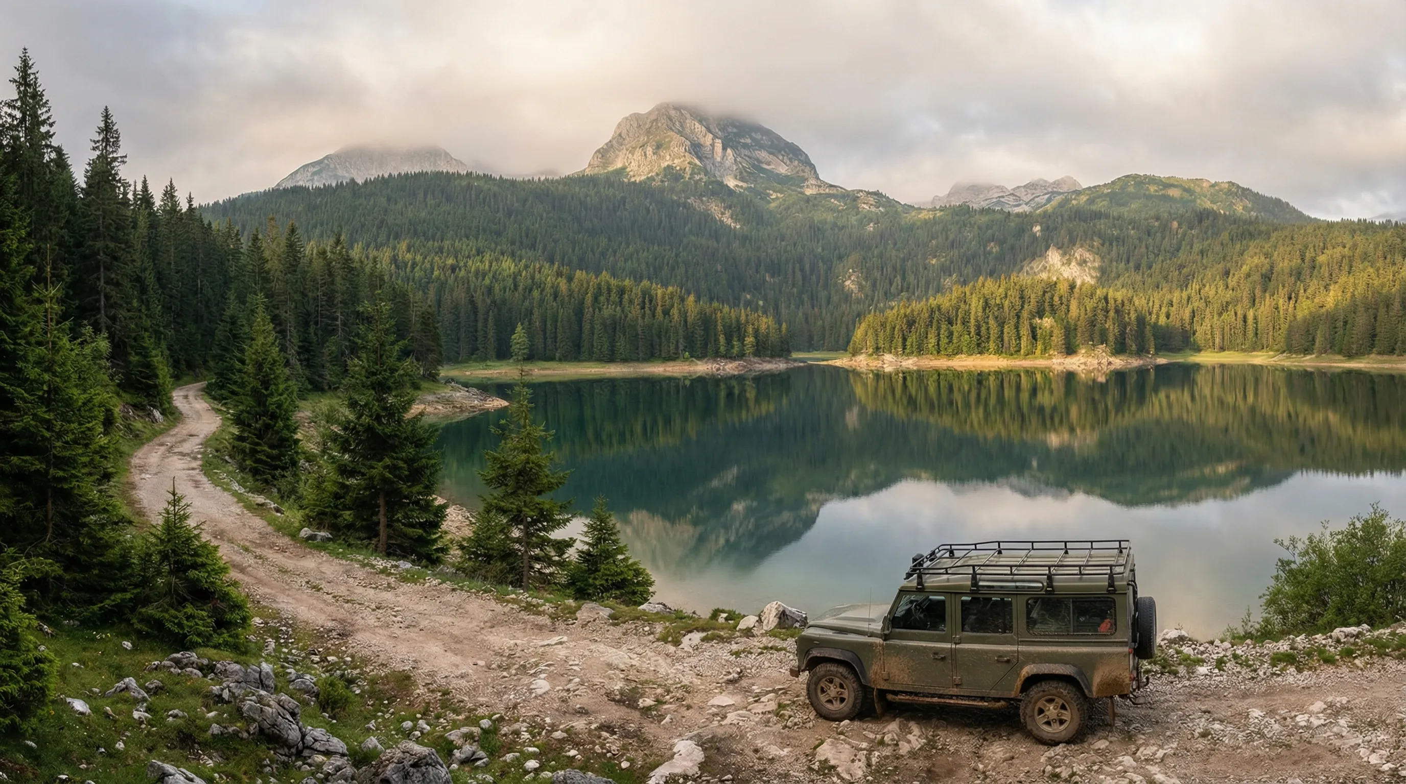
| Susica to Black Lake approach | 20 km | Gravel road, improving | Easy-Moderate | Mountain lakes, meadows |
| Black Lake to Zabljak | 20 km | Paved/gravel | Easy | Tourist area, facilities |
Morning: Zabljak to the Tara Canyon rim (km 0-45)
Zabljak sits at 1,450 metres on the plateau northeast of Durmitor. The town has fuel, several supermarkets, and an atmosphere that hovers between Alpine resort and Balkan market town. Leave early — 07:00 if possible — to catch morning light on the canyon and avoid the tourist traffic that builds later.
From the centre of Zabljak, head east on the road signed toward Djurdjevica Tara (the famous Tara Bridge). For the first 10 km, the road is paved and fast. At the national park boundary, the surface transitions to maintained gravel — compacted, graded, and suitable for any vehicle. This section follows the canyon rim at approximately 1,200-1,400 metres elevation, with periodic viewpoints on the left (south) side.
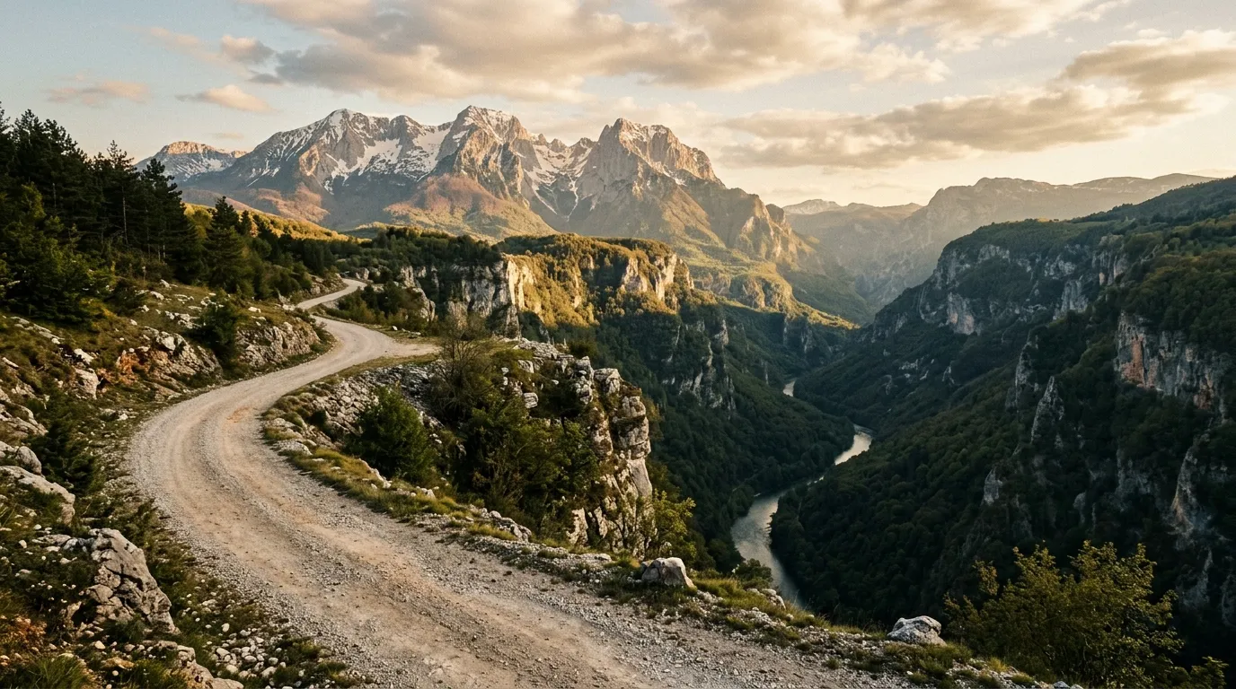
The Tara Canyon is Europe’s deepest river canyon. At its maximum, the walls drop 1,300 metres from rim to river. From the driving route, you see perhaps 800 metres of that drop — enough to make the stomach interesting. The viewpoints are informal — pull-offs where the trees thin and the ground drops away. There are no guardrails, no fences, no signs saying “Viewpoint 3 — Photo Opportunity.” You park, you walk to the edge, you look down.
At km 25, the route passes near the Djurdjevica Bridge — a 365-metre concrete arch spanning the canyon, built in 1940 and blown up during WWII by its own engineer to delay the Italian advance. It has been rebuilt and now carries the main road. It is worth stopping, but be aware this is also the single most tourist-visited point in Durmitor. Zip-line operators, souvenir sellers, and tour buses congregate here. Move on.
Beyond the bridge, the route leaves the main road and follows a secondary gravel track along the canyon’s south rim. The surface begins to deteriorate — less maintenance, more ruts, grass in the centre. The views continue. Traffic drops to near zero.
Midday: The forest section (km 45-75)
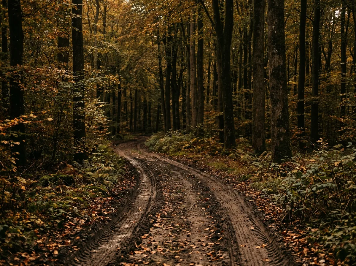
At approximately km 45, the route turns west and enters the forest that covers Durmitor’s eastern flank. This is the crux of the ring. The track is ungraded, one lane, and passes through dense beech and fir forest for 20 km. In dry conditions, the surface is compact earth with roots and rock — manageable in a high-clearance 2WD with care. After rain, it becomes a different proposition entirely.
Beech forest on a mountain slope holds water like a sponge. The canopy blocks sun. The soil stays wet for days after rain. What was a firm track three days ago becomes a series of connected mud wallows, some with standing water, some with ruts deep enough to trap a wheel. We drove this section in August after two dry weeks and it was fine — firm, shaded, atmospheric. On a previous visit in June, the same section took two hours of careful driving, three uses of the tow strap (self-recovery, anchored to trees), and a detailed reconsideration of what “Moderate” means.
The forest itself is extraordinary regardless of conditions. The beeches are old and tall — 25-30 metres in places — and the track runs through them like a corridor in a gothic cathedral, the canopy closing overhead and the light filtering green through the leaves. If you are not struggling with mud, it is beautiful driving.
At km 65, the track crosses a stream — shallow in summer, potentially deeper in spring. A rocky ford with a firm gravel bottom. In dry conditions, any 4x4 crosses without incident. After heavy rain, the water can rise to 40 cm and the approach becomes slippery.
Afternoon: Susica Canyon and the western return (km 75-120)
Emerging from the forest, the route climbs to a saddle at approximately 1,800 metres and the terrain opens dramatically. Alpine meadow replaces forest, and the Susica Canyon appears to the south — a smaller, steeper, less-visited sibling of the Tara Canyon. There is an informal viewpoint where the track crests the saddle (approximately 43.0917 degrees N, 19.0250 degrees E) that offers one of the best panoramas on the entire route: Durmitor’s summit ridges to the north, the Susica canyon dropping away to the south, and the Sinjajevina plateau visible in the distance.
From the Susica overlook, the track descends westward through meadow and scattered pine into a broad valley on Durmitor’s southern flank. The surface improves — graded gravel, wider, with occasional signs of recent maintenance. Side tracks to mountain lakes branch off at several points; most are short (1-2 km) and lead to glacial tarns surrounded by grass and rock. We explored two of them — neither had names on our map — and found them empty and perfectly still.
The final 20 km returning to Zabljak follows the western approach road, which is alternately paved and gravel. The route passes within 3 km of Black Lake (Crno Jezero), Durmitor’s most famous feature — a glacial lake at the foot of the main peak. The lake is beautiful and heavily visited. If you arrive after 17:00, the day-trippers have left and the light is golden on the water. A wooden walkway circles the lake, taking about 45 minutes to walk.
Zabljak appears as the light fades, and the ring closes where it started. We arrived at 17:30, having left at 07:00, which accounts for 10.5 hours including stops. The driving itself is about 6-7 hours of wheel time.
Vehicle and conditions
The Durmitor Ring is the most accessible of our Montenegro routes, but it still benefits from a 4x4. The forest section in particular will punish overconfidence in a 2WD if conditions are wet. We drove the route in a Suzuki Jimny (adequate but cramped for a long day) and would recommend something slightly larger for comfort — Dacia Duster 4x4, Hyundai Tucson 4WD, or similar.
Tire pressure: we dropped from 2.2 bar to 1.8 bar at the start of the forest section and re-inflated for the gravel return. The compressor took 5 minutes per tire, which is worth the comfort and traction improvement on the softer surfaces.
The route is a loop from Zabljak, which simplifies logistics — no staging vehicles, no one-way transfers. Carry a full tank and a 10L jerry can. Our Jimny used approximately 11L/100km for the circuit, which is within range of a full tank but leaves no margin for exploration.
Practical details
| Item | Detail |
|---|---|
| Total distance | ~120 km |
| Driving time | 6-8 hours |
| Start/end | Zabljak (43.1500 degrees N, 19.0833 degrees E) |
| Fuel | Zabljak. Fill up before departure. |
| Park entry | 3 EUR per person (collected at gates) |
| Mobile coverage | Intermittent. Good in Zabljak. Patchy on canyon rim. None in forest. |
| Accommodation | Zabljak: hotels and guesthouses from 25-80 EUR/night |
| Food | Zabljak: restaurants and supermarkets. Nothing on the route itself. |
Connections
The Durmitor Ring provides a natural introduction to Montenegro’s highlands. For a more challenging extension, combine it with the Sinjajevina Highland Tracks, accessible from the southern portion of the ring road. For the most demanding driving Montenegro offers, add the Prokletije Border Trail, a day’s drive southeast.
Return to the Montenegro hub for the full country overview.