Sinjajevina Highland Tracks
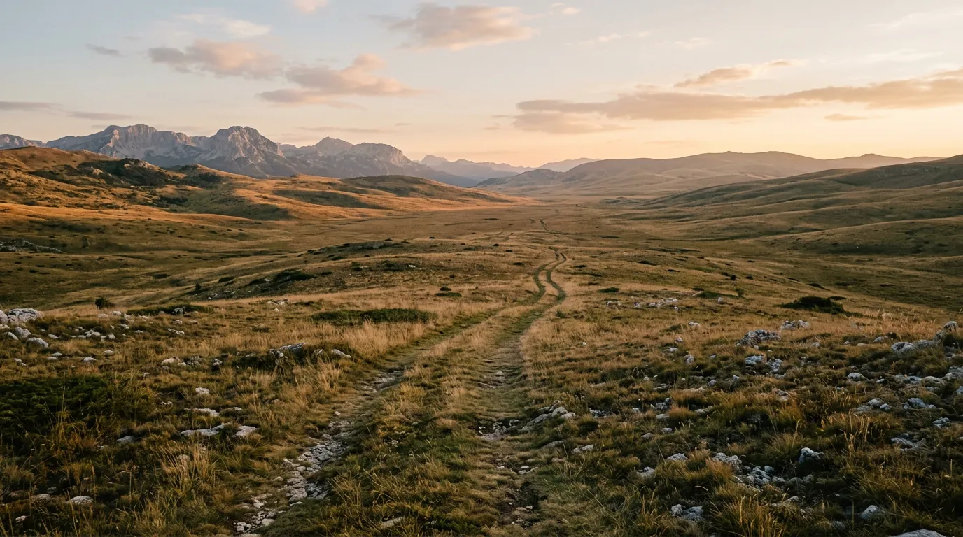
Sinjajevina is a plateau that should not exist. At 2,000 metres above sea level, with an area of approximately 500 square kilometres, it is the highest and largest mountain grassland in Europe. No trees. No buildings beyond seasonal shepherd shelters. No permanent roads. No fences. The grass runs to the horizon in every direction, broken only by low ridges of exposed limestone and the occasional cluster of horses standing very still against the sky.
We drove across it because a shepherd in Kolasin told us we could. “There are tracks,” he said, waving generally northward. “The shepherds use them. You have a Jimny? You can follow.” The tracks turned out to be parallel impressions in the grass that appeared and disappeared with the terrain, and following them required the GPS skills of a marine navigator and the faith of someone whose source of route intelligence was a man with a flock.
The result was one of the strangest and most memorable drives of the project. Not because of difficulty — the surface is grass and firm earth, the gradients are gentle, and the technical challenge is low. The challenge is navigational. There are no junctions because there are no roads. There are no landmarks because everything looks the same. There is a 360-degree horizon of grass and mountain and sky, and if the fog rolls in — which it does, abruptly and without consultation — you are navigating a featureless plateau at 2,000 metres with zero visibility and a GPS that says your destination is 15 km northeast along a track that no longer exists.
Understanding the plateau
Sinjajevina is not wilderness in the conventional sense. It is a cultural landscape — a high-altitude pasture that has been grazed by livestock for centuries. The plateau is dotted with katuns — seasonal shepherd settlements of stone huts and rough timber shelters — that are occupied from June to September. During these months, shepherds bring their flocks up from the valleys to graze the mountain grass, and the plateau has a sparse but genuine human presence.
The tracks exist to serve this pastoral economy. They connect katuns to each other and to the access roads at the plateau’s edge. They are not maintained. They are not marked. They shift as the sheep shift — when a wet section becomes impassable, the shepherds simply drive beside it, creating a new track that parallels the old one. Over time, this produces a braided network of parallel ruts across the grass, which on the map looks like five tracks and on the ground looks like a problem.
The plateau has also been used by the military. During the Yugoslav era, Sinjajevina hosted military exercises, and concrete observation bunkers from that period still stand on several ridgelines. These are useful as navigation landmarks — they are visible from several kilometres in clear weather and appear on OsmAnd as ruins.
In recent years, Sinjajevina has been at the centre of a controversy over a proposed military training ground. Local communities and environmental groups have opposed the plan. We mention this not as politics but as context: be respectful of the land, stick to established tracks, and do not drive off-track across meadow. The plateau is someone’s livelihood.
Access points
Sinjajevina can be approached from several directions. We used two access points:
From Kolasin (south): A gravel road climbs north from Kolasin through forest to the plateau’s southern edge. The road is maintained for the first 15 km, then transitions to an unmarked track. GPS: plateau access from south at approximately 42.8833 degrees N, 19.2500 degrees E.
From Zabljak area (northwest): A secondary gravel road heads south from the Zabljak-Mojkovac road and reaches the plateau’s northwestern edge after about 20 km of forest driving. Less used but more direct.
We entered from the south (Kolasin approach) and exited northeast toward Mojkovac. This provides a transit across the plateau rather than a loop, which is more interesting but requires either two vehicles or a willingness to drive back on paved roads.
Driving the plateau
The initial ascent (access road to plateau edge)
From Kolasin, the gravel road climbs through dense forest on a series of switchbacks that gain about 800 metres over 15 km. The surface is reasonable gravel — maintained for forestry access — and a high-clearance 2WD could manage it in dry conditions. At approximately 1,600 metres, the forest thins to scattered birch and the landscape opens. Within another kilometre, you are on the plateau proper: grass, sky, and a track that becomes two parallel ruts in the turf.
The plateau crossing (30-40 km)
There is no single route across Sinjajevina. What we drove was a roughly northeast trajectory from the southern access point to the northern edge, following shepherd tracks where they existed and navigating by GPS where they did not. Total distance across the plateau was approximately 35 km. Total time was 4 hours, which includes 45 minutes of stops and 30 minutes of being lost.
The surface across most of the plateau is firm grassland over compacted earth. The grass is short — grazed by sheep and horses — and the earth is surprisingly firm in summer. A 4x4 is necessary not for traction (the surface provides plenty) but for the occasional soft section where water collects in shallow depressions and the earth becomes bog. These sections are invisible until you are in them. The grass looks the same. The surface feels the same. Then the front wheels drop 15 cm and the chassis settles and the rear wheels are spinning on saturated earth.
We encountered three such sections. Two we spotted in time (the grass was fractionally greener, which is the tell) and drove around. The third caught us. The Jimny sank to its axles in black mud that had the consistency of cake batter. Recovery boards under the rear wheels, low-range reverse, 10 minutes of work. No damage, but a thorough demonstration of why recovery boards belong in the vehicle at all times.
Navigation
This is the core challenge of Sinjajevina and the reason we rate it “Challenging” despite the gentle terrain. On a clear day with GPS, the plateau is straightforward — you pick a bearing, follow the tracks when they align with your heading, and navigate around obstacles as they appear. On a foggy day, which can arrive without warning, the plateau becomes a featureless grey void in which every direction looks identical and the GPS screen is your only reference to reality.
We had fog for approximately 45 minutes of our crossing. It descended from the west at midday, reducing visibility to perhaps 100 metres. The tracks vanished. The ridgelines vanished. We navigated by GPS bearing alone, driving at 15 km/h and stopping frequently to verify our position. It was not dangerous — the terrain is flat and obstacle-free — but it was disorienting in a way that mountain driving never is, because mountains at least tell you which way is up.
Our GPS tools: OsmAnd with offline topographic maps (essential — it shows the shepherd tracks and the katun locations), plus a handheld Garmin as backup. We also carried a physical compass. If both electronic devices fail on a foggy Sinjajevina plateau, a compass and a known bearing are the difference between driving to safety and driving in circles.
What you will see
The plateau is not empty. It looks empty from the access road, but as you drive across it, details accumulate.
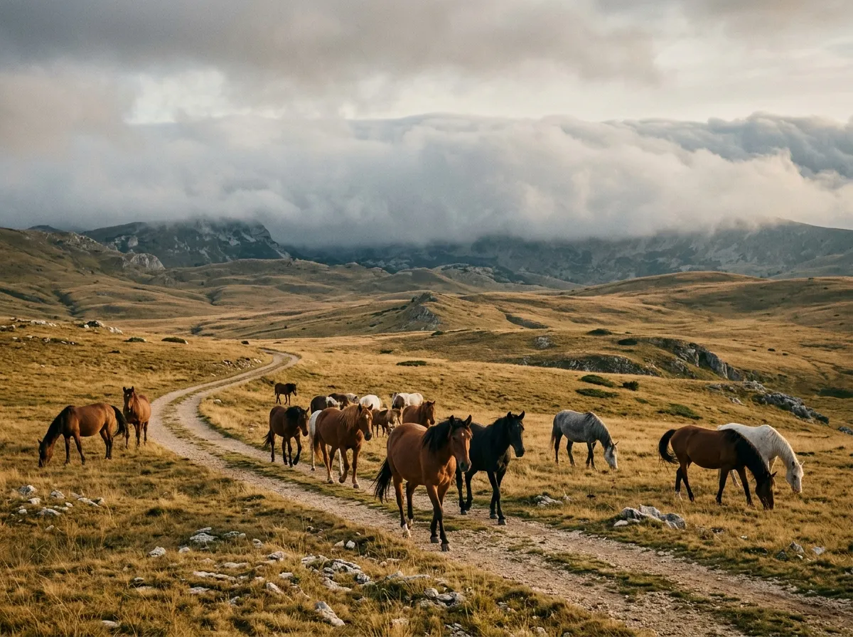
Horses. Sinjajevina is home to free-roaming Balkan mountain horses — a semi-wild breed that grazes the plateau in bands of 10-30 animals. They are not domesticated and they are not skittish. They will stand and watch you drive past with an expression of mild curiosity, and they are photogenic in the extreme against the grassland backdrop.
Katuns. The shepherd settlements are scattered across the plateau, each consisting of 3-8 stone buildings and a corral. Most are occupied in summer. The shepherds are welcoming but not expectant — they do not sell things, they do not offer tours, they are at work. If you stop to talk, bring a small gift: coffee, tobacco, or a bottle of something. The intelligence they provide about track conditions is invaluable.
Military ruins. The Yugoslav-era observation bunkers appear on ridgelines as concrete boxes, some intact and some partially collapsed. They provide useful navigation landmarks and, in one case, emergency shelter from a hailstorm. The concrete is cold but dry, which is more than the Jimny offered during a sudden June downpour on our first visit.
Wildflowers. In June and early July, the plateau blooms in a way that turns the grass from green to polychrome — yellow, purple, blue, white. The species density is remarkable; ecologists have recorded over 1,500 plant species on Sinjajevina. We are not botanists, but even a non-expert can appreciate driving through meadow that looks like an Impressionist painting.
Practical details
| Item | Detail |
|---|---|
| Total distance | ~60 km (access road + plateau crossing) |
| Driving time | 4-7 hours depending on navigation and conditions |
| Fuel | Kolasin (south) or Mojkovac (northeast). Fill up completely. Carry 10L jerry can. |
| Water | 3L per person. No water sources on the plateau (streams exist but are fouled by livestock). |
| Season | June through September. Snow and mud outside this window. |
| Mobile coverage | None on the plateau. Some coverage at the edges. |
| Accommodation | Kolasin: hotels and guesthouses. Zabljak: full range. No accommodation on the plateau. |
| Weather | Changes rapidly. Fog, rain, hail all possible with minimal warning. Carry warm layers. |
Conditions and recommendations
The plateau dries fully by late June in a normal year. July and August are the driest months and the best for driving — firm ground, minimal fog, long days. September brings the risk of early snow at this altitude, and the shepherds begin to descend. After mid-September, the plateau is increasingly deserted and the weather increasingly hostile.
Drive in the morning. The afternoon thunderstorm pattern that affects all Montenegrin highlands is particularly pronounced on Sinjajevina because there is no shelter of any kind. A lightning storm on a treeless plateau at 2,000 metres is an experience best avoided.
If the fog descends and you are not confident in your navigation: stop. The plateau is safe to sit on. Turn off the engine, wait for the fog to lift (usually 30-90 minutes), and continue when you can see. Driving blind on a plateau with hidden bogs is not courageous driving; it is the prologue to a recovery story.
Connections
Sinjajevina is accessible from the southern section of the Durmitor Ring Road and combines naturally with it for a multi-day Montenegrin highlands itinerary. For contrasting terrain, the Prokletije Border Trail delivers technical rock driving as a counterpoint to Sinjajevina’s open grassland.
Return to the Montenegro hub for the full country overview.