Tizi n’Test Pass
The lorry appeared around the blind corner at approximately the same speed we were travelling in the opposite direction, which is to say too fast for the available road width. The road at this point was perhaps four metres across. The lorry occupied about two and a half of them. We occupied about two. The mathematics did not add up. We pulled left until our wing mirror was brushing the rock face, the lorry pulled right until its wheels were on the edge of a drop that went somewhere we preferred not to contemplate, and we passed each other with a gap of maybe fifteen centimetres between our respective mirrors. The lorry driver waved. We did not wave back because our hands were occupied with the steering wheel and the concept of continued existence.
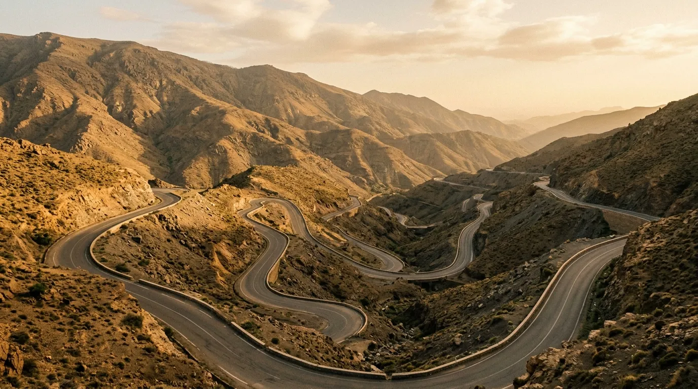
This is the Tizi n’Test pass. It is 180 km of mountain road connecting Marrakech to the Souss Valley, crossing the western High Atlas at 2,092 metres. It is paved — mostly — and narrow — always — and beautiful in a way that you can only appreciate on the sections where you are not actively trying to avoid oncoming trucks. The French built the road in the 1930s, and while it has been improved since then, the basic engineering philosophy remains: a single lane of asphalt carved into the side of a mountain range, with occasional wider spots where two vehicles can pass, and nothing between you and the valley floor except the quality of your steering inputs.
We drove it south to north in a day, starting from the Souss Valley floor and climbing to the pass, then descending to the outskirts of Marrakech. This guide covers the drive in the more common north-to-south direction, starting from Marrakech.
Route overview
| Section | Distance | Elevation | Terrain | Time |
|---|---|---|---|---|
| Marrakech to Asni | ~50 km | 450m to 1,200m | Paved, two-lane | 1 hour |
| Asni to Tizi n’Test summit | ~80 km | 1,200m to 2,092m | Paved, single-lane switchbacks | 2.5-3 hours |
| Summit to Tin Mal Mosque | ~30 km | 2,092m to 1,200m | Paved descent, narrow | 1 hour |
| Tin Mal to Taroudant | ~70 km | 1,200m to 500m | Paved, widening | 1.5 hours |
Total: approximately 180 km, 6-7 hours of driving. This assumes a pace appropriate to the road conditions, which means slower than you think. The pass section between Asni and Tin Mal averages about 25-30 km/h, and attempting more than that on the blind corners is a decision that the lorry drivers coming the other way may not endorse.
The drive north to south
Marrakech to Asni (50 km)
Leave Marrakech early — 7:00 AM if possible. The road south (Route 203) is a decent two-lane highway that climbs gradually through olive groves and farmland toward the Atlas foothills. Asni is the last town of any size before the pass, and it has the last reliable fuel. Fill up here. The petrol station is on the left side of the road as you pass through town, and it is well-marked.
Asni also has a Saturday souk that is worth a stop if your timing aligns — it is a genuine local market rather than a tourist production, and the produce coming down from the mountain villages is excellent.
From Asni, the road narrows. The two-lane highway becomes a single-lane road with occasional passing places, and the climbing begins in earnest.
The ascent: Asni to the summit (80 km)
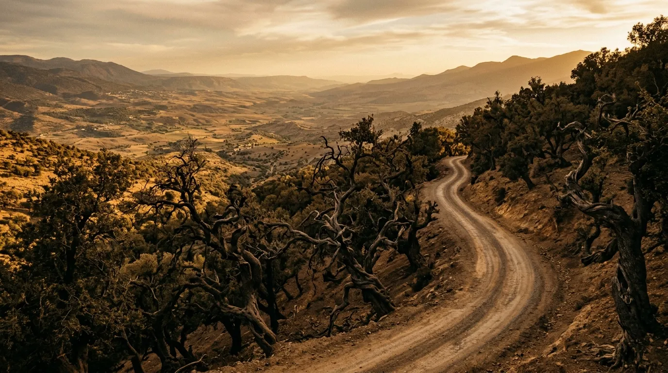
This is the main event. Eighty kilometres of continuous climbing through the western High Atlas, with the road gaining approximately 900 vertical metres in a series of switchbacks, hairpins, and traverses across increasingly dramatic terrain.
The first 30 km above Asni are relatively gentle — the road winds through walnut groves and Berber villages, the gradient is manageable, and the surface is in reasonable condition. The villages here are built of the same pink-brown stone as the mountains around them, and they have a way of appearing and disappearing as the road curves around valley heads and across ridgelines.
At approximately the 30 km mark, the road enters the gorge section. The valley narrows, the walls steepen, and the road begins a series of tight switchbacks that climb the northern face of the range. This is where the driving gets serious.
What “single-lane with blind corners” means in practice:
The road is paved but narrow enough that two vehicles cannot pass simultaneously at most points. Passing requires one vehicle to pull into a wider section (usually a slight widening at a corner) while the other squeezes past. Oncoming traffic announces itself with horn blasts — you should do the same on every blind corner. The locals are practised at this and will yield or advance depending on who has the better position. Tourist drivers sometimes freeze, which makes things worse.
The gradient is steady but not extreme — 8-12% on most switchbacks, occasionally steeper. The challenge is sustained attention rather than technical difficulty. You are continuously turning, continuously watching for oncoming traffic, and continuously managing the drop-off on the outside of each bend. There are no guardrails on most of the pass. Where guardrails exist, they are the thin metal type that provide psychological comfort rather than meaningful protection.
The summit: Tizi n’Test (2,092m)
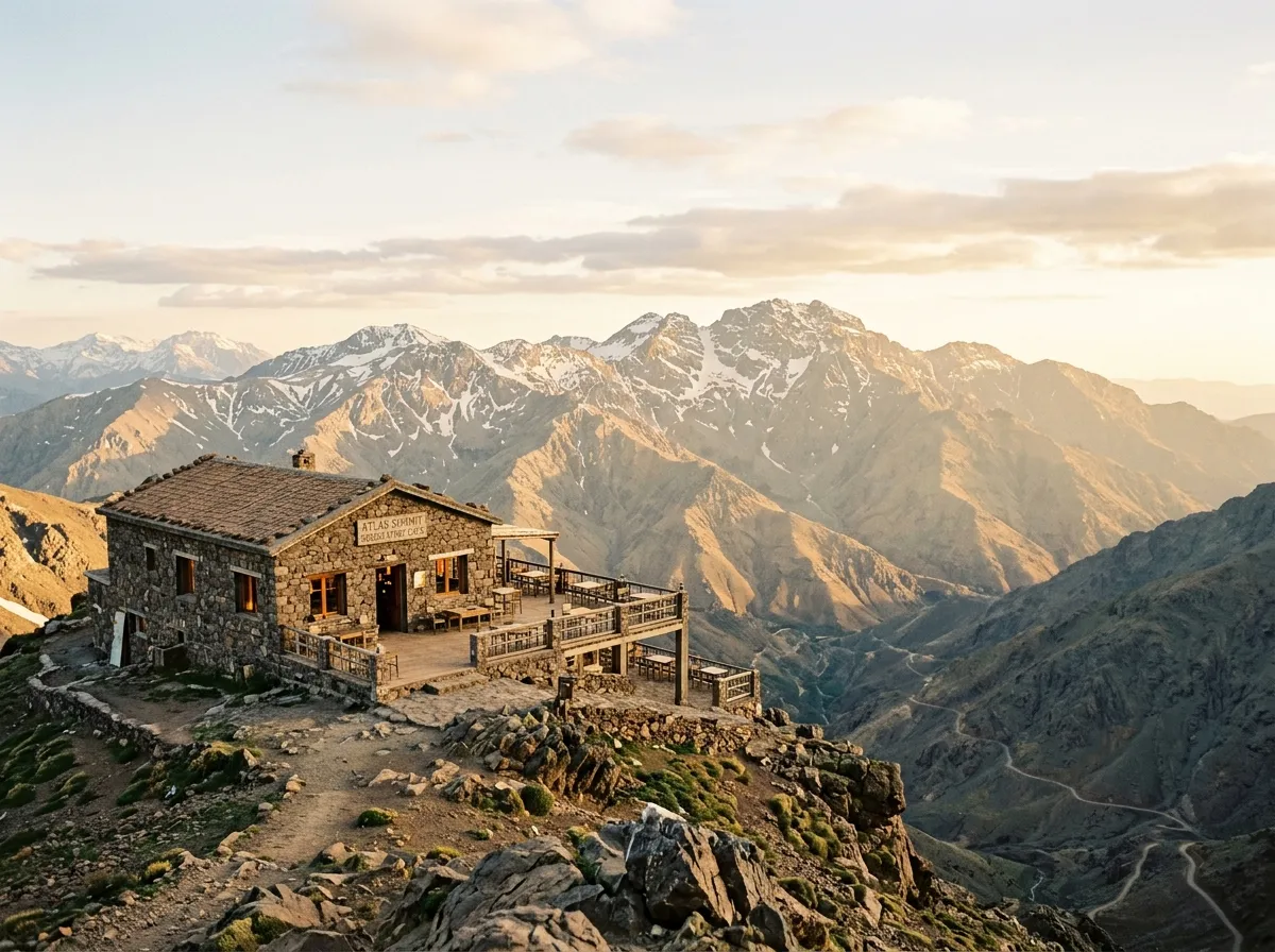
The pass summit is marked by a collection of small buildings — cafes, souvenir stalls, and a telecommunications tower that looks incongruous against the mountain backdrop. Stop here. The views are panoramic: the High Atlas extending northeast toward Toubkal (4,167m, the highest peak in North Africa), the Anti-Atlas visible to the south, and on clear days the Souss Plain stretching to the coast.
The cafes serve mint tea and basic food (tagine, omelettes, bread). The tea is strong and sweet and costs about 10 MAD (less than 1 EUR). The view is free. This is one of the few places in Morocco where the tourist economy has not inflated prices to match the scenery, probably because the scenery is accessible only to people willing to drive the road.
Elevation note: At 2,092 metres, temperatures at the summit are typically 10-15 degrees cooler than the lowlands. In winter (December to February), snow is possible and the pass occasionally closes for a few days. Check conditions before starting if you are driving between November and March.
The descent: Summit to Tin Mal (30 km)
The southern descent is steeper and more dramatic than the northern climb. The road drops from the summit into the valley of the Oued Nfis through a series of switchbacks that are tighter and more exposed than anything on the northern side. The surface is paved but patchy in places — sections of the descent have loose gravel where the asphalt has deteriorated, and these require attention, especially in corners.
The geological character changes as you descend. The northern side of the Atlas is predominantly grey limestone. The southern side exposes red sandstone and conglomerate — the same colour shift you see across the Atlas range, reflecting the different climatic and depositional conditions on each side.
Tin Mal Mosque (30.8717° N, 8.1333° W)
About 30 km below the summit, the road passes through the village of Tin Mal, where the ruins of the Tin Mal Mosque stand beside the river. This is a genuinely significant building — it was founded in 1156 by Abd al-Mu’min, the first Almohad caliph, and its architectural innovations (the pointed horseshoe arches, the decorative stucco work, the minaret design) influenced mosque construction across North Africa and Spain. The Koutoubia Mosque in Marrakech is essentially a larger version of this building.
The mosque was restored in the 1990s and can be visited. Entry is free, though a guardian will probably materialise to offer a tour (a small tip of 20-30 MAD is appropriate). The building is partially roofless, which gives it a quality of ruin that adds to the atmosphere. The interior columns and arches are beautifully proportioned.
We spent about 45 minutes here, which is right for the building and the setting. It is the most important historical site on the pass and it receives a fraction of the visitors that Marrakech’s more accessible monuments attract.
The argan forest detours
Below Tin Mal, the road enters the argan forest — a belt of endemic woodland that grows on the southern flanks of the western Atlas and nowhere else on Earth except a small area in Mexico. The argan trees are low, twisted, and distinctive, and the local economy revolves around argan oil production (the trees produce a nut that is pressed for culinary and cosmetic oil).
Several dirt tracks branch off the main road into the argan forest and the Berber villages within it. These are the off-road component of the Tizi n’Test drive:
Detour 1: Argan Forest loop (approximately 15 km round trip). A gravel track leaves the main road about 10 km below Tin Mal and loops through a section of dense argan woodland, passing through two small villages. The track is passable in a high-clearance 2WD in dry conditions, but after rain the clay surface becomes slippery. Allow about an hour.
Detour 2: Village track to Imoulas (approximately 20 km round trip). A rougher track branches east from the main road toward the village of Imoulas, which sits in a hanging valley above the main river. This needs a 4x4 — the last 5 km have rocky sections with steps. The village is a traditional Berber settlement with terraced agriculture on the valley sides, and the view back toward the Atlas ridge is the best we found on the southern descent.
These detours are not essential — the pass itself is the main attraction — but they provide a change of pace from the continuous paved switchbacks, and they offer a glimpse of the rural Atlas that the main road passes above.
Descent to Taroudant (70 km)
Below the argan forest, the road opens up. The switchbacks ease into broader curves, the road widens to two lanes, and the gradient decreases as you approach the Souss Plain. The final section into Taroudant is flat and fast — a welcome change after five hours of mountain driving.
Taroudant is a walled market town often described as a smaller, quieter Marrakech. It has fuel stations, accommodation, and restaurants. It is a good overnight stop if you plan to continue east toward the gorges or south toward the Anti-Atlas.
Vehicle requirements
The main paved road over Tizi n’Test is driveable in any vehicle with reasonable ground clearance. A standard 2WD rental car (Dacia Logan, Renault Clio) can make it, though the narrow sections and blind corners will be stressful. We recommend a high-clearance vehicle as a minimum — the road surface has potholes and broken edges that are easier to manage with extra clearance.
For the argan forest detours, a 4x4 or at least a high-clearance 2WD is recommended. The village track to Imoulas requires a 4x4.
| Vehicle type | Main road | Argan forest loop | Imoulas track |
|---|---|---|---|
| Standard 2WD | Possible but tight | Not recommended | No |
| High-clearance 2WD | Comfortable | Yes (dry conditions) | No |
| 4x4 | Comfortable | Yes | Yes |
Practical details
Fuel
Fill up in Asni (north side) or Taroudant (south side). There is no fuel on the pass itself — 130 km of mountain road between the last station in Asni and the first station south of the pass. Our vehicle consumed approximately 14L/100km on the pass (higher than normal due to low-speed climbing), so budget about 18 litres for the mountain section.
Food and water
The summit cafes provide basic meals and drinks. The villages along the route have small shops but no restaurants. Carry at least 2 litres of water per person and some food — if you stop for photographs, detours, and the mosque, you will be on the road for 8-10 hours.
Driving at night
Do not drive the pass at night. The blind corners, the lack of guardrails, the occasional goat on the road, and the possibility of oncoming trucks without functioning lights all make night driving on this road a genuinely bad idea. Plan your timing to complete the pass section in daylight.
Combining with other routes
From Taroudant, the road east leads to Ouarzazate (approximately 300 km via the N10, paved), which is the gateway to the Dades and Todra Gorges and the Sahara approaches. From Ouarzazate, Merzouga and the start of the Sahara piste is approximately 350 km east.
The Tizi n’Test pass works well as the opening move of a Morocco circuit: cross the Atlas on day one, drive east along the southern base of the range, then head into the gorges and desert. The return to Marrakech can be via the better-known Tizi n’Tichka pass (higher at 2,260m but wider and better maintained), completing a loop.
What makes this pass worth driving
Morocco has several Atlas passes. Tizi n’Tichka (Route 9, Marrakech to Ouarzazate) is more famous and more trafficked. Tizi n’Talrhemt and others are less known. Tizi n’Test occupies the middle ground — known enough to be maintained, obscure enough to be relatively quiet, and dramatically narrow enough to feel like a proper mountain pass rather than a highway that happens to climb.
The combination of the road itself, the Tin Mal Mosque, the argan forests, and the views from the summit makes it one of the most rewarding single-day drives in Morocco. It asks for attention, it rewards patience, and it provides a thorough introduction to the principle that Moroccan mountain roads are not to be taken casually. If this is your first Atlas pass, it is a good one to start with. If you survive the lorries.