Sahara Piste: Merzouga to Zagora
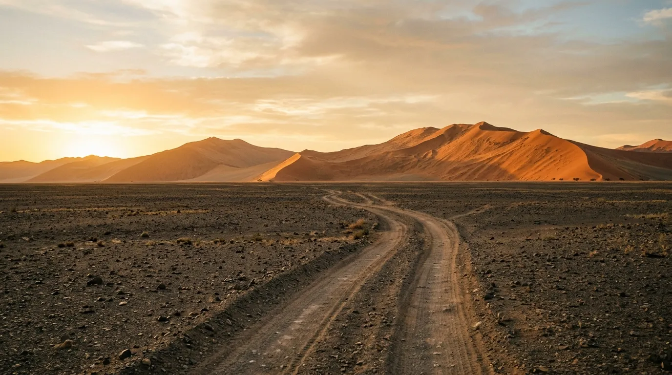
There is a point, roughly 120 km into the crossing, where you lose sight of the last mountain ridge behind you and the next geographical feature ahead has not yet appeared. You are driving across reg — hammada, the Moroccans call it — a flat expanse of dark stone and gravel that extends to the horizon in every direction. The surface is like a badly maintained car park: firm enough to drive on, rough enough to shake every bolt in the vehicle loose, and featureless enough that your brain starts inventing landmarks where none exist. That shimmering shape on the horizon is not a building. It is heat haze. The dark line to the south is not a tree line. It is more reg. The piste markers — small cairns of stacked stones, sometimes supplemented by old oil drums painted white — appear at intervals of 500 metres to 2 km, and following them is the entirety of your navigational task.
The Merzouga to Zagora piste is the classic Sahara crossing in Morocco. It connects the two main tourist gateways to the Moroccan Sahara — Merzouga in the east (famous for the Erg Chebbi dunes) and Zagora in the west (famous for a road sign claiming Timbuktu is 52 days away by camel). Between them lies approximately 350 km of desert: sand pistes, reg plains, dry lake beds, and isolated settlements that appear on some maps and not others. This is expert-level driving. It is not a day trip, it is not a tour, and it is not something to attempt without preparation, equipment, and a realistic understanding of what “remote” means in the context of North African geography.
We drove it over two and a half days in late October, and this guide documents everything we learned.
Route overview
The piste does not follow a single, definitive track. There are multiple routes between Merzouga and Zagora, varying in difficulty, distance, and the features they pass through. The route we drove follows the most commonly used piste via Taouz, Alnif, Nkob, and the Lake Iriki basin.
| Day | Section | Distance | Terrain | Key features |
|---|---|---|---|---|
| 1 | Merzouga to Erg Chebbi to Taouz | ~80 km | Sand, gravel, paved sections | Erg Chebbi dunes, Taouz fossil beds |
| 2 | Taouz to Alnif to south of Nkob | ~150 km | Reg, gravel piste, rocky track | Reg plains, Anti-Atlas foothills |
| 3 | Nkob to Lake Iriki to Zagora | ~120 km | Dry lake bed, sand, gravel | Lake Iriki, Draa Valley approach |
Total: approximately 350 km, 2.5 to 3 days. Daily distances look moderate on paper but the terrain limits speed severely. Average pace on the reg sections is 25-35 km/h. Sand sections drop to 15-25 km/h. The dry lake bed allows brief bursts of 50 km/h on the hardest surface, but the surrounding soft edges punish any attempt to maintain that speed.
Preparation
Vehicle
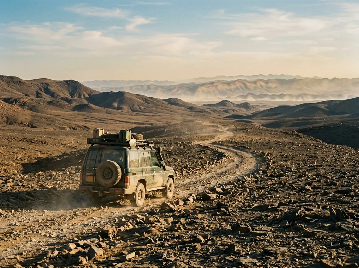
This piste requires a 4x4 with low-range transfer case. Full stop. There are sand sections where two-wheel drive will bury the vehicle, rock sections where ground clearance under 200mm will result in damage, and reg sections where the sustained vibration over 200+ km will test every suspension component and body mount. We drove a Toyota Land Cruiser 200 series with 230mm of clearance, upgraded suspension, and all-terrain tires. It was adequate. A Suzuki Jimny would also work if you are lighter on fuel and supplies. A rental Dacia Duster 4x4, which is Morocco’s most common “off-road” rental, is marginal — the suspension is not built for full-day reg driving.
Navigation
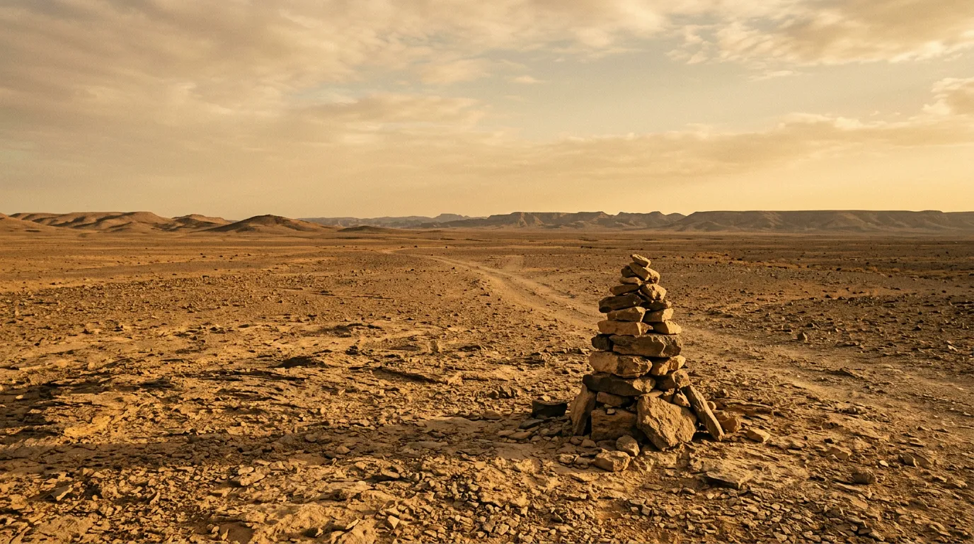
This is the critical item. The piste markers are the primary navigation aid, but they are not always present, not always visible, and not always accurate. Wind buries cairns. Rain dissolves them. People build new cairns for unknown purposes that lead in wrong directions. You need supplementary navigation.
GPS tracks: The best resource is locally purchased GPS track files. The tourist offices in Merzouga and Rissani sell SD cards with GPX files for approximately 50-100 MAD (5-10 EUR). These contain waypoint tracks recorded by desert guides and are generally accurate, though sections may be outdated where sand has shifted the optimal route. Load them into a dedicated GPS unit or a phone running OsmAnd or Maps.me.
Paper maps: The Michelin map 742 (Morocco) shows the main piste route but without sufficient detail for navigation. The French IGN 1:100,000 topographic maps are better but hard to find. Carry a paper map as a backup for electronic failure.
Compass: A basic compass is useful when piste markers and GPS disagree, which they will. The general bearing from Merzouga to Zagora is roughly southwest. If you are heading northeast for more than 10 minutes, something has gone wrong.
Fuel
There is no fuel between Merzouga and Zagora that you can rely on. The town of Alnif, roughly midway on our route, has a fuel station, but its opening hours are irregular and its supply is not guaranteed. Plan as if Alnif does not exist.
Fuel calculation:
| Factor | Value |
|---|---|
| Total distance | ~350 km |
| Average consumption (desert driving) | 20-25 L/100km |
| Total fuel needed | 70-88 litres |
| Standard tank (Land Cruiser 200) | 93 litres |
| Required reserve | Minimum 20L in jerry cans |
We carried two 10L jerry cans in addition to a full tank, which gave us a theoretical range of approximately 450 km. We used about 80 litres for the crossing, leaving a comfortable reserve. Do not attempt this crossing with less than 20L of extra fuel.
Water
Carry a minimum of 10 litres per person for the full crossing. We carried 25 litres for two people over three days and used about 18 litres. The Bedouin settlements along the route may have water, but it is unreliable and not always safe to drink without treatment.
Recovery equipment
| Item | Required | Notes |
|---|---|---|
| Recovery boards (pair) | Yes | Used five times during the crossing |
| Tow strap (5-tonne rated) | Yes | Carried but unused (solo vehicle) |
| Tire deflator + compressor | Yes | Essential for sand sections |
| Folding shovel | Yes | Used repeatedly |
| Hi-lift jack or exhaust jack | Recommended | For vehicles buried beyond board depth |
| Spare tire (full-size) | Yes | Carry two if possible |
| Tire repair kit (plug type) | Yes | Reg stones cause punctures |
Day 1: Merzouga to Taouz (80 km)
Erg Chebbi at dawn
Merzouga sits at the base of Erg Chebbi, Morocco’s most famous dune field. The dunes rise to about 150 metres and glow orange at sunrise in a way that justifies every tourist photograph ever taken of them. If you have not seen them, arrive the evening before and camp or stay at one of the auberges at the dune base. The sunrise is worth the early alarm.
The piste south from Merzouga skirts the eastern edge of Erg Chebbi. The first 20 km are sandy — the dune field extends east in fingers of soft sand that cross the track, and you will need deflated tires (15-18 PSI) to keep moving. The GPS track is important here because the visual track is often buried under fresh sand.
Taouz and the fossil beds (31.0000° N, 3.9833° W)
Taouz is a small settlement about 60 km south of Merzouga, set in a landscape of dark, fossil-rich stone. The area is famous for trilobite fossils — the local economy revolves around fossil mining and sales, and roadside vendors will appear with trays of specimens the moment you stop. The fossils are genuine (mostly), well-preserved, and reasonably priced: small trilobites for 20-50 MAD, larger specimens for 100-300 MAD.
Beyond Taouz, the landscape transitions from sand to reg. This is the beginning of the serious desert driving.
The reg begins
Reg — hammada — is the dominant terrain of the central crossing. It is a flat plain of dark stone fragments, the product of millions of years of wind erosion stripping sand and leaving the heavier rock fragments behind as a pavement. The surface is firm, which is good for driving, but it is also brutally rough. The stones are angular, the ruts are deep (cut by truck tires in wet conditions and baked hard), and the vibration at any speed above 30 km/h is severe enough to loosen anything that is not bolted, welded, or tied down.
We lost a wing mirror bracket on the first day of reg driving. By the end of the second day, we had tightened every accessible bolt on the vehicle twice and developed an intimate relationship with the sound of rattling metal.
Reg driving tips:
Reduce tire pressure slightly (22-25 PSI) to absorb the vibration. Keep speed below 30 km/h — the temptation to go faster on what looks like a flat plain is strong, but the ruts and embedded rocks will punish you. Follow existing tire tracks where they are visible, as these mark the smoothest line through the ruts. Check your vehicle regularly for loosened components — mirrors, roof rack mounts, battery terminals, and spare wheel brackets are the usual casualties.
Day 2: Taouz to south of Nkob (150 km)
The long reg crossing
Day 2 is the core of the piste — 150 km of predominantly reg terrain with sections of rocky track and gravel piste. This is the day that tests your patience more than your driving skill. The terrain is unvarying: flat, dark, featureless stone extending to the horizon. The piste markers appear with irregular frequency. The driving is not technically difficult — it is relentlessly, monotonously demanding.
We stopped every 60-90 minutes to check the vehicle, stretch, and confirm our GPS position against the track. At one point we deviated from the piste to avoid a section of particularly deep ruts and spent 20 minutes navigating back to the markers. The desert is forgiving of detours — the surface is flat and the terrain is open — but being off-piste without GPS reference points is an efficient way to become genuinely lost.
Alnif (31.1167° N, 5.1667° W)
Alnif is a small town at the intersection of the piste and a paved road (Route 3454). It has a fuel station, which was open when we arrived at midday, and several shops selling water and basic supplies. This is the only guaranteed resupply point on the crossing. Fill your tank even if it is three-quarters full. Buy water even if you have water. Alnif is the safety margin.
The town also marks the transition from the eastern reg to the Anti-Atlas foothills — the terrain becomes slightly more varied south and west of Alnif, with rocky hills, dry wadis, and the occasional stand of scrubby vegetation.
Nkob and the kasbahs (30.8667° N, 5.8667° W)
Nkob is a larger town known for its concentration of traditional kasbahs — fortified mud-brick residences that were the standard architecture of southern Morocco before concrete arrived. There are reportedly 45 kasbahs in and around Nkob, some restored and functioning as guest houses, others slowly returning to the earth. We stayed at a kasbah guest house (Kasbah Baha Baha, approximately 300-400 MAD for a double room including dinner) and spent the evening on the rooftop terrace looking south toward the desert we had crossed and the desert we had yet to cross.
Nkob has fuel, shops, and a limited mobile signal. It is the last town of any substance before the Lake Iriki basin.
Day 3: Nkob to Zagora (120 km)
Lake Iriki basin
South of Nkob, the piste descends into the basin that once held Lake Iriki — a large, now-dry lake bed that extends approximately 30 km from east to west. The surface of the dry lake is cracked white clay, as flat as an airport runway and nearly as smooth. This is the fastest driving of the entire crossing — we reached 55 km/h on the hardest sections, which felt like light speed after two days of 25 km/h reg driving.
The dry lake is also disorienting. There are no landmarks, no elevation changes, and no reference points for distance. The far shore of the lake bed is visible as a faint dark line but it does not appear to get closer regardless of how long you drive. GPS is essential here — without it, you could easily drive in a wide arc without realising you had deviated from the piste.
At the western edge of the lake bed, the surface transitions abruptly to soft sand. This is a trap — vehicles arriving at speed from the hard lake surface hit the soft sand without warning and bog down immediately. We had been warned by a desert guide in Merzouga and approached the transition slowly. Others, apparently, have not been so fortunate — the western edge of Lake Iriki is littered with tire tracks that terminate in deep ruts where vehicles have dug in.
Draa Valley approach
West of Lake Iriki, the piste enters the Draa Valley — a long, narrow oasis that follows the Draa River (intermittently) from the Atlas Mountains to the desert. The landscape changes dramatically: palm groves, irrigated fields, kasbahs, and the first paved road in 200 km. The transition from empty desert to cultivated valley is abrupt and slightly surreal — you round a low hill and suddenly there are date palms, children on bicycles, and a donkey standing in the middle of the track.
Zagora (30.3300° N, 5.8400° W)
Zagora is the western gateway to the Moroccan Sahara and the traditional end point of the piste from Merzouga. The town is famous for a road sign that reads “Tombouctou 52 Jours” — 52 days to Timbuktu by camel caravan, a reminder of the trans-Saharan trade routes that once made this region prosperous.
Zagora has fuel, accommodation, restaurants, and mobile coverage. After three days of desert driving, these things feel luxurious. We parked, refuelled, showered off approximately three kilograms of dust, and ate a tagine that tasted better than it probably was, partly because it was the first hot meal we had not cooked over a camp stove.
Navigation in detail
The piste between Merzouga and Zagora is not a single track. There are multiple routes, variants, and shortcuts, and the “correct” piste shifts over time as sand buries old tracks and wind exposes new ones. Here is what we learned about staying on course:
Trust the GPS track over the piste markers when they disagree. The GPS tracks sold in Merzouga are recorded by guides who drive the route regularly. The piste markers may have been repositioned by wind, goats, or well-meaning strangers.
When in doubt, stop. It is better to spend 10 minutes studying the GPS and looking for the next marker through binoculars than to drive 5 km in the wrong direction and have to backtrack on already-punishing terrain.
The wind erases tracks quickly. In the sand sections, tire tracks from vehicles that passed hours ago may be invisible. This is normal. Follow the GPS.
Intersecting tracks are common. Not every track leads to Zagora. Many lead to Bedouin camps, wells, fossil sites, or nowhere. If you reach an intersection that your GPS does not show, default to the general southwest bearing toward Zagora.
Weather and hazards
Sandstorms
The chergui wind blows from the southeast and can carry sand to a density that reduces visibility to less than 10 metres. If a sandstorm hits while you are driving, stop. Turn off the engine (to avoid sand ingestion), close all windows and vents, and wait. Storms typically last 1-4 hours. Driving in a sandstorm is impossible — you cannot see the piste markers, you cannot see the terrain, and the sand will damage your vehicle’s air filter, paint, and any exposed components.
We did not experience a sandstorm during our crossing, which we attribute to luck and season (late October). November through March is the lowest-risk period. Spring (March to May) brings the most frequent and severe storms.
Heat
In summer (June to September), daytime temperatures on the reg exceed 50 degrees Celsius. At those temperatures, vehicle overheating is likely, tire blowouts are common, and human heat exhaustion can become life-threatening within hours. Do not attempt this crossing in summer. The October-to-April window exists for a reason.
Tire damage
The reg stones are sharp and angular. Punctures are common, and sidewall damage from protruding rocks is possible. We had one slow puncture on the second day, which we repaired with a plug kit. Carry at least one full-size spare tire — two if your vehicle has space. The time to discover your spare is flat is not 150 km from the nearest town.
Combining with other routes
From Zagora, the paved road north leads to Ouarzazate (approximately 170 km), which connects to the Dades and Todra Gorges and the Tizi n’Tichka pass back to Marrakech. This creates the classic Morocco circuit: Atlas pass south, gorges east, Sahara crossing west, then loop back north.
From Merzouga at the eastern end, the paved road north leads to Errachidia and then west to the gorges — approaching them from the opposite direction. Either direction works as a circuit component.
For comparable desert driving, the Wadi Rum desert tracks in Jordan offer sand driving in a more contained environment, and the Wahiba Sands crossing in Oman provides expert-level dune driving.
The honest summary
The Merzouga to Zagora piste is not a comfortable drive. It is not a scenic drive in the conventional sense — the scenery is often a flat, dark plain extending to a shimmering horizon. It is not a drive that will make your Instagram followers jealous, because most of the photographs look like variations on the theme of “rocks and sky.”
What it is, is a genuine desert crossing. It is the experience of driving for hours without seeing another vehicle, another person, or another structure. It is the experience of navigating by cairns and GPS through terrain that does not care whether you find the next marker or not. It is the experience of arriving at Zagora after three days of vibration, dust, and concentration, and understanding in a practical way what “remote” actually means.
We would do it again. We would bring better earplugs for the reg vibration.