Dades & Todra Gorges
After two days of desert piste where the most exciting visual stimulus was a slightly differently shaped rock, the Dades Gorge appears like an hallucination. You are driving along the Road of a Thousand Kasbahs — a flat, straight highway through the Draa-Tafilalet region — when the mountains to the north split open and a canyon appears, its walls stacked in layers of pink and brown rock that fold and twist like geological origami. Somewhere up that canyon, a road climbs through a series of hairpin turns that have been photographed so many times they have their own recognisable silhouette, like the Eiffel Tower or the Sydney Opera House but made of switchbacks and sandstone.
The Dades and Todra gorges are two parallel canyons cutting into the southern face of the High Atlas, separated by about 50 km of highway. They are Morocco’s most famous driving canyons, and unlike most of the routes in our Morocco collection, they are accessible in a 2WD. The main roads through both gorges are paved — narrow in places, dramatic throughout, but paved. This makes them the entry-level option for driving in Morocco’s canyon country, which does not mean they are boring. It means they are available to anyone with a rental car and a willingness to share single-lane roads with tour buses.
The side canyons, however, are not paved. And the side canyons are where it gets interesting.
Route overview
The drive connects Boumalne Dades in the west (the gateway town for the Dades Gorge) to Tinghir in the east (the gateway for Todra), via the N10 highway. The total distance, including the gorge roads and a selection of side-canyon detours, is approximately 140 km.
| Section | Distance | Terrain | Vehicle needed | Time |
|---|---|---|---|---|
| Boumalne Dades to Dades hairpins | ~30 km | Paved, narrow switchbacks | Any vehicle | 1.5 hours |
| Dades side canyon detour | ~15 km | Gravel, rocky track | 4x4 or high-clearance 2WD | 1.5 hours |
| Dades return to N10, east to Tinghir | ~50 km | Paved highway | Any vehicle | 45 min |
| Tinghir to Todra Gorge narrows | ~15 km | Paved, single-lane in canyon | Any vehicle | 30 min |
| Todra upper canyon detour | ~15 km | Gravel, wadi bed | 4x4 | 1.5 hours |
| Todra return to Tinghir | ~15 km | Paved | Any vehicle | 30 min |
Total driving time: 6-8 hours. This can be compressed into a single long day or spread over two days with an overnight in the Dades Gorge, which we recommend — the gorge hotels are comfortable and the morning light on the canyon walls is worth waking up for.
Dades Gorge
The approach: Boumalne Dades
Boumalne Dades is a small town on the N10 highway, about 115 km east of Ouarzazate. It has fuel stations, ATMs, a few hotels, and a surprising number of tourist shops selling fossils and carpets. Fill up here — there is no fuel in the gorge. The gorge road (Route R704) leaves the north side of town and enters the canyon immediately.
The lower gorge (15 km)
The first 15 km of the Dades road run through the lower gorge, where the canyon is relatively wide and the kasbahs line the valley floor. The road is paved and manageable in any vehicle. The scenery builds gradually — the valley walls rise from 50 metres to 200 metres, the rock layers become more pronounced, and the kasbahs become more photogenic.
The Monkey Fingers (Pattes de Singe) rock formations appear on the right side of the road about 8 km into the gorge. These are tall, thin pillars of conglomerate rock eroded into shapes that resemble — if you have a generous imagination and possibly some mint tea — the fingers of a very large monkey. Geological accuracy demands they be described as hoodoo formations created by differential erosion of layered sedimentary rock. Tourist accuracy demands they be called Monkey Fingers. Stop for a photograph. Everyone does.
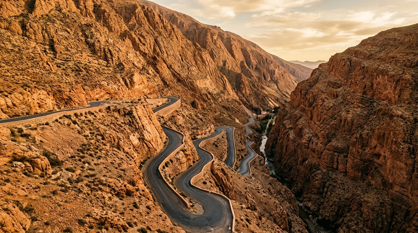
The hairpins (5 km)
At approximately the 15 km mark, the road begins the famous switchback section. The hairpins climb 400 vertical metres up the eastern wall of the gorge in a series of tight, banked turns carved into the cliff face. The road is paved and maintained, but it is narrow — barely wider than a single vehicle in places — and the drop-offs are unguarded.
Driving notes for the hairpins:
Drive uphill if you have the choice. Uphill drivers have better visibility into the corners and are on the inside of the turns (rock wall side) rather than the outside (cliff side). Downhill drivers are on the outside, which is psychologically demanding and practically more dangerous if anything goes wrong.
Use your horn on every blind corner. This is standard practice in Morocco and not considered rude — it is considered sensible.
The viewpoint at the top of the hairpins (31.4833° N, 5.9317° W) is the spot where the famous photograph is taken — looking down at the zigzag road below, with the canyon beyond and the kasbahs in the valley floor. It is worth the stop, and it is worth arriving early (before 9:00 AM) when the light is on the eastern wall and the shadows define the switchback pattern.
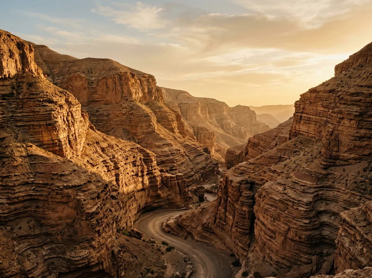
Dades side canyon detour
Above the hairpins, the paved road continues north into the upper Dades Valley, eventually reaching a dead end at a small Berber settlement. Before that dead end, a gravel track branches east into a side canyon that is narrower, less visited, and geologically more interesting than the main gorge.
The track is rough — embedded rocks, loose gravel, a few short steep sections — and requires a high-clearance 2WD at minimum. A 4x4 is more comfortable and allows you to push further into the canyon. The side canyon is about 7 km deep (one-way), and the walls close in progressively until you are driving through a slot barely wider than the vehicle. The rock layers here are tilted and folded, showing the forces that built the Atlas range in a way the main gorge does not.
We drove about 5 km into the side canyon before the track deteriorated beyond what our high-clearance rental would handle. A 4x4 could probably reach the end. The return drive offered different lighting and perspectives, which is always the saving grace of out-and-back routes.
Where to stay in the Dades Gorge
The lower gorge has a dozen or so hotels and guest houses, most built in traditional kasbah style with rooftop terraces facing the canyon. Prices range from 200 MAD (basic room, shared bathroom) to 600 MAD (comfortable room, private bathroom, breakfast included) per night. We stayed at a mid-range place near the Monkey Fingers and can confirm that the rooftop terrace at sunset, with the canyon walls going from pink to copper to violet, justifies the 400 MAD more than adequately.
The connecting drive: Dades to Todra (50 km)
Return from the Dades Gorge to Boumalne Dades and take the N10 highway east toward Tinghir. This 50 km stretch of highway passes through a flat valley between the Atlas range to the north and the pre-Saharan hills to the south. The landscape is semi-arid scrubland punctuated by irrigated oasis strips along the rivers — green ribbons of palm trees and gardens in otherwise brown terrain.
The road is good, the traffic is moderate, and the driving is uneventful. Use it as recovery time between the gorges.
Tinghir is slightly larger than Boumalne Dades and has more services: fuel, banks, a hospital, several hotels, and a weekly souk. It is also the base for most Todra Gorge visits.
Todra Gorge
The approach from Tinghir (15 km)
The road to Todra Gorge (Route 6902) leaves the north side of Tinghir and follows the river upstream through a palmerie — a palm-lined oasis that narrows progressively as the canyon walls converge. The first 10 km are relatively open, with small villages and agricultural terraces on either side. The canyon walls are visible ahead, rising above the palms, getting larger with every kilometre.
The last 5 km are the transition from open valley to gorge. The walls close in from both sides, the road narrows, and the palm trees thin out as the canyon becomes too narrow and steep for anything to grow. The sense of scale shifts — you stop looking at the landscape and start looking up.
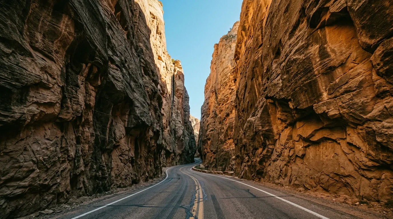
The narrows (31.5883° N, 5.5717° W)
The Todra narrows are the main event. For approximately 600 metres, the canyon walls rise 300 metres on either side while the gap at the bottom narrows to about 10 metres. The road passes through this gap on a single lane of asphalt, with the river running alongside (or, depending on the season, across the road surface).
The narrows are spectacular. There is no other word for it. The walls are vertical, striated, and close enough that the light only reaches the canyon floor for a few hours around midday. The scale is difficult to photograph — your camera sees a gap between two walls, but your eyes see a gap between two walls that extend further up than your neck can tilt.
Driving the narrows:
The road is single-lane inside the canyon. Oncoming traffic is managed by courtesy and horn signals — the driver who reaches a wider section first pulls over and waits. Tour buses use this road, and they take up the entire width. If you meet one inside the narrows, you are backing up until you find a spot to let it pass. This is not dangerous, just slow and occasionally awkward.
Parking at the narrows is limited. There is a small car park at the entrance to the narrowest section, which fills up by mid-morning with tour buses and rental cars. Arrive before 9:00 AM for the best experience — fewer vehicles, better light (the morning sun illuminates the upper walls while the floor is still in shadow, creating dramatic contrast), and the acoustic quality of the canyon (footsteps and river sounds amplified between the walls) is best appreciated without a crowd.
Todra upper canyon detour
Above the narrows, the paved road continues another 5 km into the upper valley before ending. Beyond the road end, a gravel track follows the wadi upstream into the upper canyon. This is the detour that most tourists skip, and it is the best driving of the Todra experience.
The track runs along the wadi bed for approximately 7 km (one-way), alternating between gravel banks and sections where you are driving through the shallow river itself. The canyon is narrower here than the famous narrows below — there are sections where the walls are less than 5 metres apart and the vehicle barely fits through. The geology is wilder too: folded layers, cave openings in the walls, and erosion patterns that look designed.
This section requires a 4x4. The river crossings are shallow (shin-deep in dry season) but the bed is rocky and uneven, and the banks between crossings are soft gravel that can bog a 2WD. We drove about 5 km upstream before the track became a boulder field, and returned satisfied that we had seen the Todra that the postcards miss.
Water level warning: The upper canyon can flood quickly after rain in the Atlas Mountains. The catchment is large and rain 50 km upstream can send a wall of water down the wadi within hours. Check the weather forecast before entering the upper canyon, and do not camp in the wadi bed. The flood debris wedged 3 metres above the wadi floor is not there for decoration.
Practical information
Fuel
| Location | Distance from Dades | Distance from Todra | Notes |
|---|---|---|---|
| Boumalne Dades | 0 km | 50 km | Multiple stations |
| Tinghir | 50 km | 0 km | Multiple stations |
| Errachidia (east) | 120 km | 70 km | Major town |
| Ouarzazate (west) | 115 km | 165 km | Major town |
The gorges themselves have no fuel. The fuel gap is manageable — the round trip from either gateway town to the end of the gorge and back is under 70 km, which is well within any vehicle’s range. If you are combining the two gorges in a single day, fuel up at either Boumalne or Tinghir.
Costs
| Item | Cost |
|---|---|
| Fuel (Boumalne to gorges and back) | ~80-100 MAD |
| Gorge hotel (mid-range, Dades) | 300-600 MAD per night |
| Todra narrows parking | Free (or 10 MAD to a self-appointed attendant) |
| Meals (roadside restaurants) | 40-80 MAD per person |
| Monkey Fingers “guide” (optional) | 50-100 MAD |
The guide question
Both gorges have self-appointed guides who will approach you at parking areas and viewpoints. In the Dades, they offer to show you the “secret viewpoint” for the hairpin photograph (which is not secret — it is a marked viewpoint with a concrete platform). In Todra, they offer to guide you through the upper canyon. The guides are generally knowledgeable and not aggressive. If you want a guide, agree on a price before starting (50-100 MAD for a half-day is typical). If you do not want one, a polite “non, merci” is sufficient.
Seasonal notes
The gorges are driveable year-round, which makes them unusual among Morocco’s off-road attractions. Spring (March to May) is the best season: wildflowers in the valleys, snowmelt feeding the rivers, and comfortable temperatures (20-28 degrees). Autumn (September to November) is excellent as well. Summer is hot (35-40 degrees at gorge level) but the canyon walls provide shade, and the swimming pools in the rivers are a legitimate cooling strategy. Winter is cool and dry — good for driving, less good for camping.
Combining with other routes
The gorges sit midway on the classic Morocco circuit:
From the west: Drive Tizi n’Test over the Atlas from Marrakech, then east through Ouarzazate to the gorges. Two driving days.
From the east: The gorges are the first major attraction west of Merzouga, making them a natural follow-up to the Sahara piste or a prelude to it.
Continuing east: From Tinghir, the road to Merzouga is approximately 200 km via Errachidia. From Merzouga, the Sahara piste heads south and west to Zagora.
For comparable gorge driving in other countries, the Dana to Feynan canyon trail in Jordan offers more demanding terrain with similar geological drama, and the Jebel Akhdar mountain road in Oman provides an equivalent mountain ascent with canyon views.
What makes the gorges worth the detour
In a country full of dramatic landscapes, the Dades and Todra gorges stand out for their accessibility and their concentrated visual impact. You do not need expedition preparation or expert driving skills. You need a rental car, a day or two, and a willingness to drive slowly on narrow roads while looking up. The main gorge roads give you the famous switchbacks and the towering narrows — the images that define Morocco’s canyon country. The side canyon detours give you the solitude, the geology, and the driving that the tour buses cannot reach.
If Morocco’s mountains and deserts are the main course, the gorges are the course that makes you reconsider the menu entirely.