Damaraland Elephant Tracks
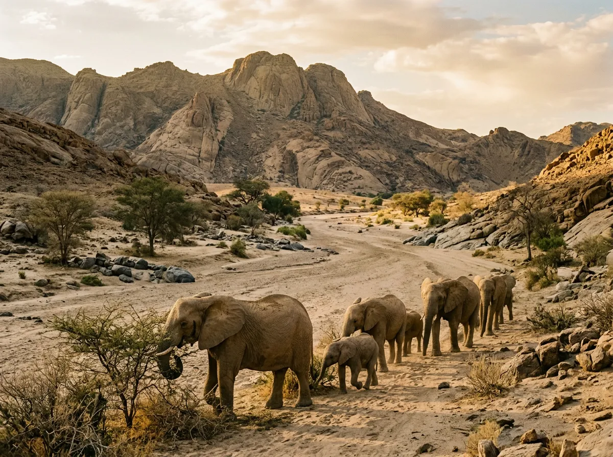
The tracker — a quiet man named Johannes from the local conservancy — pointed at a depression in the sand that looked, to our untrained eyes, like every other depression in the sand. That one is fresh, he said. Maybe two hours. See how the edges have not dried. He was pointing at an elephant footprint the size of a dinner plate, pressed into the fine sand of the Huab riverbed about 15 cm deep. We had been driving the riverbed for forty minutes, following tracks that Johannes read the way a librarian reads a catalogue — quickly, confidently, cross-referencing multiple signals into a narrative about where the herd was heading and when it had passed. We found the elephants twenty minutes later, a breeding herd of eleven animals standing in the shade of an ana tree on the riverbank, 150 metres ahead. They were not doing anything in particular. They were standing. Some were eating bark. One calf was investigating a branch with the experimental curiosity of a toddler examining a household object. We stopped the engine and sat in silence for forty-five minutes, watching, and it was the best forty-five minutes of the trip.
Damaraland occupies the northwest quadrant of Namibia between the Skeleton Coast and the Etosha Pan. The landscape is semi-arid gravel plain interrupted by dry riverbeds — the Huab, Aba-Huab, Ugab, and their tributaries — which carry water only during the brief summer rains and for the rest of the year serve as sandy highways for the wildlife that has adapted to this desert, including one of the last free-roaming populations of desert-adapted elephants in Africa. These are not a separate species — they are African bush elephants that have learned, over generations, to survive on less water, cover greater distances between food sources, and dig for underground water in the riverbeds. They are also, incidentally, the reason this route exists: following their tracks through the dry riverbeds is both the method and the purpose of driving in Damaraland.
Our route covered approximately 120 km over two days, starting at Twyfelfontein (for the rock engravings) and moving south through the Aba-Huab and Huab riverbeds in search of the elephant herds. The driving was the most technically demanding we did in Namibia. The navigation was the most uncertain. The reward was the most memorable.
Route overview
This is not a fixed route. The tracks through Damaraland’s riverbeds are not mapped, not signed, and not consistent — they shift after each rainy season as water rearranges the sand and gravel. What we describe here is the route we drove, which followed the guidance of our local tracker and the current location of the elephant herds. Your route will differ. That is the nature of tracking.
| Day | Section | Distance | Terrain | Key features |
|---|---|---|---|---|
| 1 | Twyfelfontein to Aba-Huab camp | ~50 km | Gravel road, rocky track, riverbed | Twyfelfontein engravings, Burnt Mountain, Organ Pipes |
| 2 | Aba-Huab to Huab riverbed tracking | ~70 km | Riverbed sand, gravel plain | Elephant tracking, desert-adapted wildlife |
Total: approximately 120 km. Driving time: variable (depends on tracking). Recommended time: 2 days minimum.
Day 1: Twyfelfontein and the geological formations
Twyfelfontein rock engravings
Twyfelfontein (20.4833° S, 14.3667° E) is a UNESCO World Heritage Site containing approximately 2,500 rock engravings (petroglyphs) and some rock paintings. The engravings are carved into sandstone slabs on a hillside and depict animals — elephants, rhinoceros, giraffe, gemsbok, lions — along with human figures, geometric patterns, and tracks. They were made by San (Bushmen) hunter-gatherers over a period spanning roughly 6,000 years, from about 4000 BCE to 2000 CE.
The site is accessed via a guided walk (mandatory — you cannot enter without a guide) that takes approximately 1.5 hours and covers the main engraving panels. The guides are from the local Damara community and know the engravings in detail. Our guide identified individual animals by species and behaviour (“This is a giraffe drinking — see how the legs are spread”) and pointed out engraving techniques that we would have missed entirely — the difference between pecked and incised lines, the use of natural rock features as part of the image.
The engravings are extraordinary. They are also immediately relevant to the driving we were about to do: the animals depicted at Twyfelfontein are the same animals we would encounter in the riverbeds — elephants, gemsbok, springbok. The San who carved these images were tracking the same herds through the same riverbeds, using the same basic technique of following footprints in sand. Six thousand years of methodology, and the approach has not changed.
Entry fee: 100 NAD per person (approximately 5.50 USD). Guided tours depart regularly.
Burnt Mountain and the Organ Pipes
Two geological formations near Twyfelfontein are worth the short detour. Burnt Mountain (20.4833° S, 14.4333° E) is a low ridge of slag-like rock — clinker, formed by underground coal combustion millions of years ago — that is black and red and looks precisely as though something has been burning. It has not burned in geological time, but the visual evidence is persuasive. The Organ Pipes, about 1 km away, are a collection of dolerite columns — vertical volcanic intrusions exposed by erosion — that stand 4-5 metres tall and resemble, with some imagination, the pipes of a cathedral organ.
Neither site requires more than twenty minutes, and both are accessed via short gravel tracks from the main road. Together with Twyfelfontein, they form a triangle of geological and archaeological interest that justifies a half-day stop before heading into the riverbeds.
The approach to Aba-Huab
From Twyfelfontein, the road south toward the Aba-Huab River transitions from maintained gravel to rocky track. This is where the driving changes character. The surface becomes uneven — exposed rock, loose gravel, and sections where the track disappears into a shallow riverbed and reappears on the other side. Speed drops to 20-30 km/h. The suspension starts working. And the landscape, which has been dry and brown and seemingly lifeless from the main road, begins to reveal itself: tracks in the sand, droppings on the road, the occasional springbok standing on a ridge watching your vehicle with an expression of mild interest.
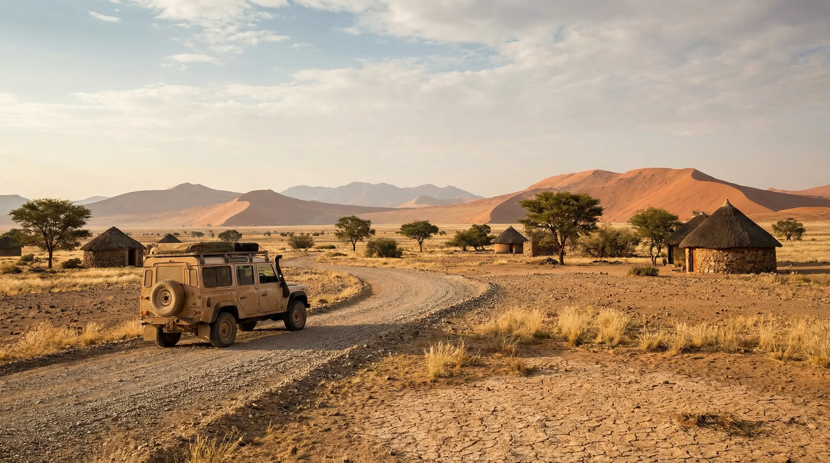
We reached the Aba-Huab camp in the late afternoon. The camp is a basic community-run facility — flat ground for camping, a fire pit, a long-drop toilet, and a view of the riverbed that in the right light looks like a scene from a nature documentary. It was here that we met Johannes, who would be our tracker the following day, and who spent the evening telling us about the elephant herds’ recent movements with the precision of someone describing the schedule of public transport.
Day 2: Elephant tracking in the Huab riverbed
The riverbed
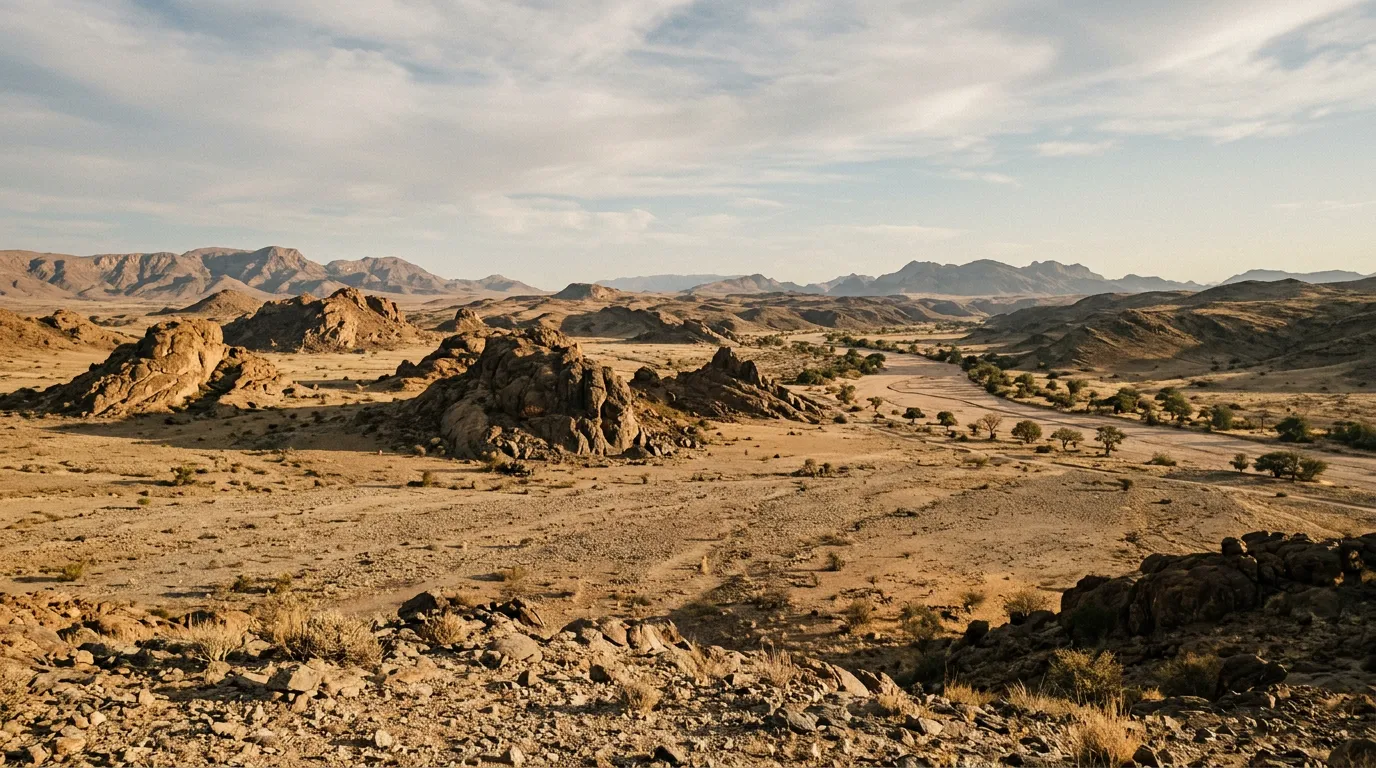
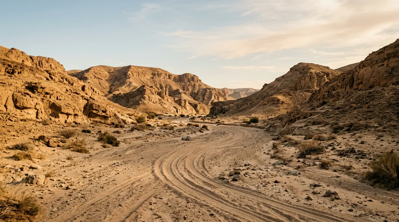
The Huab River runs approximately east-west through Damaraland, draining the highland plateau toward the Skeleton Coast. For most of the year, it carries no surface water. What it does carry is sand — deep, fine sand deposited by summer floods, overlying a gravel bed, and bounded on both sides by steep banks of compacted earth and rock. The riverbed is the road. There is no alternative.
Driving in a dry riverbed is different from driving on any other surface. The sand varies from firm (where the gravel bed is close to the surface) to treacherously soft (where recent deposits have accumulated in drifts). The width varies from 20 metres to 200 metres. The direction changes constantly as the river meanders, and at each bend the sand conditions change — deeper on the outside of the curve where the current deposited sediment, firmer on the inside where the current scoured.
Riverbed driving protocol:
| Situation | Technique | Tire pressure |
|---|---|---|
| Firm sand (gravel visible) | Normal driving, 30 km/h | 22-25 PSI |
| Soft sand (no gravel visible) | Momentum, wide turns, no stopping | 16-18 PSI |
| Very soft sand (tire tracks filling) | Maximum deflation, recovery boards ready | 14-16 PSI |
| Entering/exiting riverbed (banks) | Low range, careful line selection | 20-22 PSI |
We deflated to 18 PSI at the start and spent most of the day at that pressure. The vehicle — our rented Toyota Hilux — handled the riverbed competently but not effortlessly. We got stuck once, in a soft patch on the outside of a bend where the sand was deep enough to bury the wheels to the axle within three seconds of losing momentum. Recovery boards, reverse, try again with more speed. Johannes watched this performance from the passenger seat with the patience of someone who has seen it many times.
Finding the elephants
Elephant tracking in Damaraland is not a matter of driving to a known location. The herds move constantly — up to 70 km in a day — following underground water sources that they can apparently detect by smell or memory or some combination of the two that zoology has not fully explained. Finding them requires a tracker who knows the herds, knows the riverbeds, and knows how to read the signs: footprints, dung (fresh dung is dark and moist; old dung is pale and dry), feeding damage to trees (elephants strip bark in a way that is unmistakable once you learn to recognise it), and the subtle disturbances in sand that indicate where an animal has walked, stood, or dug for water.
Johannes tracked with the efficiency of long practice. He directed our route through the riverbed — left at this bend, stay to the inside here, stop at that ana tree — and read the signs as they appeared. We passed through areas where the elephants had been the previous day (old tracks, dried dung, stripped trees) and areas where they had not been in weeks (undisturbed sand, intact vegetation). At about 10:30, the tracks became fresher. At 11:00, Johannes pointed ahead and said: there.
The encounter
The herd was in the riverbed, about 150 metres ahead, partly screened by riverbank vegetation. Eleven animals: four adult females, two sub-adult males, and five calves of various sizes. They were feeding on the ana trees that grow along the riverbanks, stripping bark and leaves with a methodical efficiency that suggested this was a familiar stop.
We stopped the engine. Johannes indicated that we should remain in the vehicle and keep quiet. The elephants were aware of us — the matriarch had raised her head and turned her ears forward, which is the elephant equivalent of acknowledging someone’s presence without committing to a response. We sat. She assessed. After about two minutes, she returned to feeding, and the rest of the herd followed her lead.
We watched for forty-five minutes. In that time, the herd fed, a calf played in the sand by rolling onto its side and kicking, and one adult female walked to a spot in the riverbed about 30 metres from our vehicle and dug. She used her front foot, excavating sand in steady scoops until water appeared — clear, clean water rising from the sand to fill the hollow she had made. She drank. When she moved away, a calf took her place at the water hole. This is how desert elephants survive: they know where the water is, even when the water is buried.
Elephant safety
Desert elephants are wild animals that have limited contact with vehicles. They are generally tolerant of quiet observation at a distance, but they are not habituated in the way that national park elephants in East Africa sometimes are. The rules:
- Minimum distance: 100 metres. Closer if the elephants approach you (they sometimes do, out of curiosity), but never approach them.
- Engine off. The sound of an engine is more disturbing than the sound of voices.
- No sudden movements. Opening and closing doors, standing up in the vehicle, and waving cameras are all triggers.
- If the matriarch signals discomfort — leave. Ears spread wide, head raised, trunk extended toward you: this is a warning. Start the engine calmly and reverse slowly. Do not turn your back on the herd.
- Never position your vehicle between an elephant and its escape route. The riverbeds are their corridors. Block a corridor and you create a confrontation.
Johannes’s summary was more concise: “The elephants are not interested in you. Keep it that way.”
The return
From the tracking area, we drove south through the Huab riverbed and eventually picked up a gravel track leading to the D2612, which connects back to the main road network near Brandberg. The return driving was easier — we knew the riverbed by now, the tire pressures were already set, and the morning’s encounter had provided the kind of satisfaction that makes afternoon driving feel effortless.
Total distance for the day: approximately 70 km. Total time: about 8 hours, of which 45 minutes were spent watching elephants and the remainder were spent looking for them. This ratio is, according to Johannes, typical.
Practical logistics
Hiring a tracker
This is the single most important logistical decision for Damaraland driving. A local tracker from the community conservancy provides three things you cannot replicate independently: knowledge of where the elephants are, knowledge of which riverbeds are currently passable, and legitimacy with the local communities whose land you are driving through.
Contact the conservancy (Torra or Doro !Nawas — depending on which area you are exploring) in advance. Tracker fees vary but expect approximately 500-800 NAD per day (28-45 USD). This is money well spent. Attempting to track elephants independently in unmarked riverbeds without local knowledge is an efficient way to get stuck, get lost, or both.
Fuel
| Location | Distance to tracking area | Notes |
|---|---|---|
| Khorixas | ~60 km (north) | Full service, last reliable fuel |
| Palmwag | ~120 km (northwest) | Lodge fuel, limited hours |
| Uis | ~80 km (south) | Basic fuel stop |
Fuel consumption in riverbeds is high — approximately 18-22L/100km due to constant low-gear driving in sand. On 120 km of mixed terrain, expect to use 20-25 litres. A full tank from Khorixas provides ample margin, but carry a jerry can as insurance.
Camping
| Camp | Type | Facilities | Cost |
|---|---|---|---|
| Aba-Huab | Community campsite | Flat ground, fire pit, long-drop | ~150 NAD/site |
| Brandberg rest camp | Rest camp | Ablution, braai, shade | ~300 NAD/site |
| Palmwag Lodge | Lodge campsite | Full facilities, pool, restaurant | ~500 NAD/site |
Wild camping is possible with conservancy permission, but the community campsites are preferable — the fees support the conservancy that protects the elephants, and the locations are chosen for proximity to the tracking areas.
Seasonal considerations
The elephants are present year-round, but tracking conditions vary.
| Season | Riverbed conditions | Elephant behaviour | Recommendation |
|---|---|---|---|
| May – Jul | Dry, firm sand, easy driving | Herds concentrated near permanent water | Best tracking conditions |
| Aug – Oct | Very dry, some soft sand | Herds spread, longer tracking distances | Good but more driving |
| Nov – Jan | Possible flood debris, soft sand | Herds dispersing after rains | More difficult driving |
| Feb – Apr | Wet riverbeds possible, impassable sections | Herds widely dispersed | Not recommended for tracking |
The best window is May to July: the riverbeds are dry and firm, the elephants are concentrated near the remaining water sources, and the temperatures are moderate (20-30 degrees in the day, 5-10 at night).
Getting there and getting out
From Windhoek: 480 km to Khorixas via the B1 and C39. About 6 hours.
From the Skeleton Coast: From Terrace Bay, take the gravel road inland to Palmwag, then south to Twyfelfontein. About 250 km, 4-5 hours.
From Etosha: About 300 km from Okaukuejo via Khorixas. 4 hours on good gravel.
Damaraland connects naturally to the Skeleton Coast to the west and Sossusvlei to the south. A logical Namibia circuit runs: Windhoek to Sossusvlei to Skeleton Coast to Damaraland to Etosha to Windhoek, covering the country’s major landscapes in 2-3 weeks.
The honest summary
Damaraland is the most difficult driving we did in Namibia and the most rewarding. The riverbeds are unpredictable, the navigation is uncertain, and the outcome — whether you find the elephants — is not guaranteed. We found them because we hired someone who knew where to look. Without Johannes, we would have spent two days stuck in sand and seen nothing larger than a springbok.
The desert elephants themselves are remarkable not because they are spectacular — they stand and eat and dig and walk, as elephants do everywhere — but because they do these things in a landscape that appears to offer nothing. The riverbeds that look empty to a driver contain water that elephants can find. The trees that look dead to a visitor contain bark that elephants can eat. The desert that looks lifeless from the road contains a population of the largest land animal on Earth, moving through it on routes that have been used for generations, invisible to anyone not paying close attention.
Pay close attention. Hire a tracker. Deflate your tires.