Sossusvlei Gravel Approaches
There is a moment, driving south on the C14 gravel highway through the Namib-Naukluft Park, when the landscape stops being scenery and becomes geology. It happens gradually — the flat gravel plain that has been your companion since Walvis Bay develops texture, the distant ridgeline sharpens into individual peaks, and the light, which in the morning was flat and white, begins to pick out features in the terrain that were invisible an hour ago. And then, at approximately 150 km south of Walvis Bay, the first dunes appear on the eastern horizon. They are not dramatic at this distance — low shapes, darker than the plain — but they are unmistakably dunes, and they are unmistakably red. You have been driving through the oldest desert on Earth for three hours, and the desert has been saving its best for last.
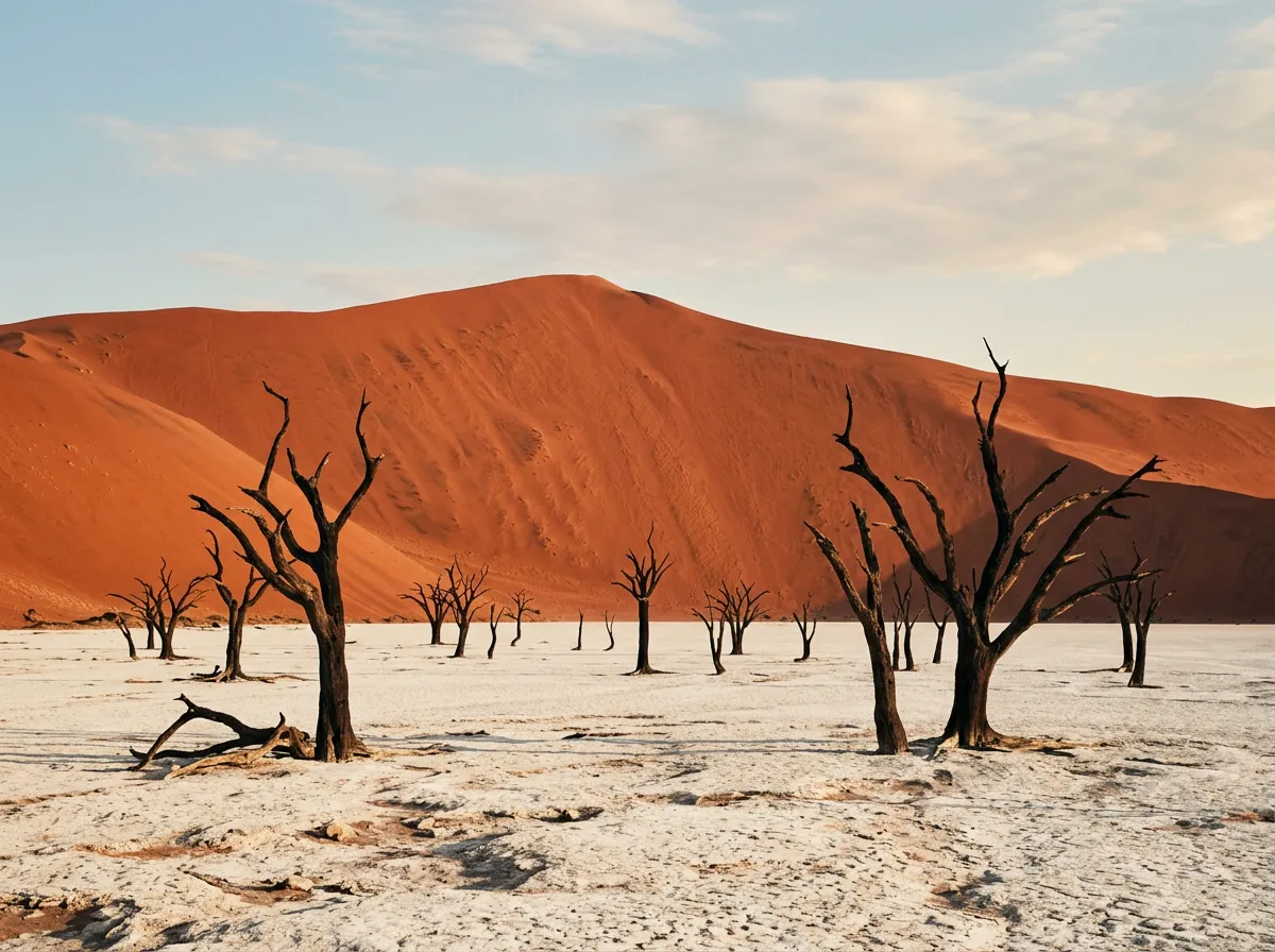
Sossusvlei is Namibia’s most famous landscape feature: a clay pan surrounded by red sand dunes that reach over 300 metres in height, making them among the tallest dunes on the planet. The dunes owe their colour to iron oxide in the sand — the iron has oxidised over millions of years, turning the grains from pale to orange to the deep rust-red that has launched a thousand photography careers. Deadvlei, a neighbouring pan containing dead camel thorn trees that have been standing — dead, black, and bleached — for approximately 900 years, has become one of the most photographed landscapes in Africa. None of this is exaggeration. Sossusvlei is as extraordinary in person as it is in photographs, and the driving to get there is worthy of documentation in its own right.
This guide covers the approach routes rather than Sossusvlei itself, because the approach routes are where the driving happens. The dunes are a destination; the 350 km of gravel highway and desert track that deliver you there are the journey, and they deserve more attention than most visitors give them.
The three approaches
There are three practical routes to Sesriem, the gate town for the Sossusvlei area. Each offers different scenery and different driving conditions.
| Route | Start | Distance | Surface | Duration | Vehicle |
|---|---|---|---|---|---|
| C14 from Walvis Bay | Walvis Bay | 350 km | Gravel highway | 5-6 hours | 2WD sufficient |
| C19 from Windhoek via Rehoboth | Windhoek | 380 km | Tar + gravel | 5 hours | 2WD sufficient |
| D826 from Aus | Aus (B4) | 280 km | Rough gravel | 5-6 hours | High-clearance 2WD minimum |
We drove the C14 from Walvis Bay, which is the most dramatic of the three approaches. The C19 from Windhoek is the fastest and most straightforward. The D826 from Aus is the roughest and the least travelled, crossing a section of the desert that feels genuinely remote. All three converge at or near Sesriem.
The C14: Walvis Bay to Sesriem
Walvis Bay to the Kuiseb Canyon
The C14 begins at the edge of Walvis Bay — a port town on the Atlantic coast that exists because of fishing and shipping and despite the desert that surrounds it on three sides. From the town, the road runs east through the Namib-Naukluft Park, climbing gently from sea level toward the central plateau. The first 50 km are flat gravel plain — the same featureless terrain that extends north to the Skeleton Coast — and the driving is fast and monotonous. Speed limit on the C14 is technically 80 km/h. Most drivers do 90-100 km/h. We maintained 80 and passed no one.
At approximately 50 km, the road enters the Kuiseb Canyon — a geological surprise in a landscape that has offered no surprises for the previous hour. The Kuiseb River has cut a canyon roughly 200 metres deep through the gravel plain, and the road drops into it via a series of switchbacks that are the most interesting driving on the C14. The canyon is narrow, the walls are layered sedimentary rock showing geological time in cross-section, and the road surface deteriorates from graded gravel to rougher stone for about 10 km. Then it climbs out the other side and the flat plain resumes, except now the desert has changed colour — the grey gravel of the northern plain gives way to red-brown sand and the first scattered dunes of the Namib proper.
The Solitaire stop
Solitaire (23.8833° S, 15.9833° E) is a place that should not exist. It is a fuel station, a bakery, and a collection of abandoned vehicles arranged in the desert approximately 80 km north of Sesriem, at the junction of the C14 and the C24. There is nothing else for 80 km in any direction. The fuel is essential — Solitaire is the last reliable pump before Sesriem, and the alternative is arriving at the park gate with a fuel warning light.
The bakery is famous. Every Namibia guidebook mentions the apple pie at Solitaire. We tried it. The verdict: it is a pie, in a desert, and the context does most of the work. The pie itself is fine — sweet, warm, adequate pastry. The experience of eating pie at a fuel station surrounded by rusting vehicles in the Namib Desert is memorable. Do not confuse the two.
Fuel price at Solitaire: approximately 15% above Windhoek prices. This is the cost of operating a fuel pump 200 km from the nearest town, and it is reasonable.
Solitaire to Sesriem
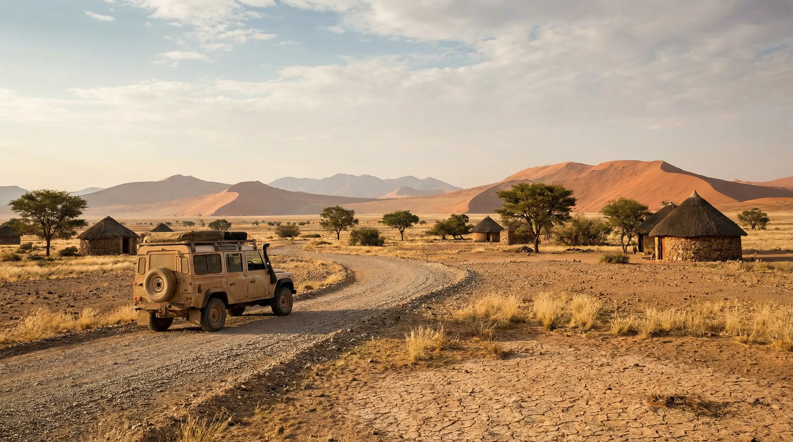
The final 80 km from Solitaire to Sesriem is the most scenic section of the C14. The road runs south-southeast through terrain that transitions from gravel plain to sand-and-gravel mixture, with the Naukluft Mountains visible to the east and the first significant dune formations appearing to the west. The dunes grow larger as you approach Sesriem, and by the last 20 km they dominate the western horizon — a wall of red sand that rises from the gravel plain without warning or transition.
Sesriem itself is a gate: a small settlement consisting of the NWR campsite, a fuel pump, a small shop, and the park gate that controls access to the Sossusvlei road. All commercial activity revolves around the gate. The timing revolves around the gate. Everything revolves around the gate.
The C19: Windhoek to Sesriem
The C19 is the standard route from the capital. It runs south from Windhoek on the B1 tarred highway to Rehoboth (95 km), then west on the C24 (tarred initially, then gravel) through the Remhoogte Pass and across the Naukluft plateau to Sesriem. Total distance: approximately 380 km. Driving time: 5 hours.
This is the least interesting route from a driving perspective — the tarred section is fast highway, the gravel section is well-maintained but through less dramatic terrain than the C14 — but it is the most efficient. If you are arriving in Namibia and want to reach Sossusvlei with minimum fuss, the C19 is the answer.
The Remhoogte Pass, approximately 200 km from Windhoek, provides the route’s one notable driving section: a gravel pass through the Naukluft range with hairpin turns and a gradient that tests brakes on the descent. It is brief but enjoyable.
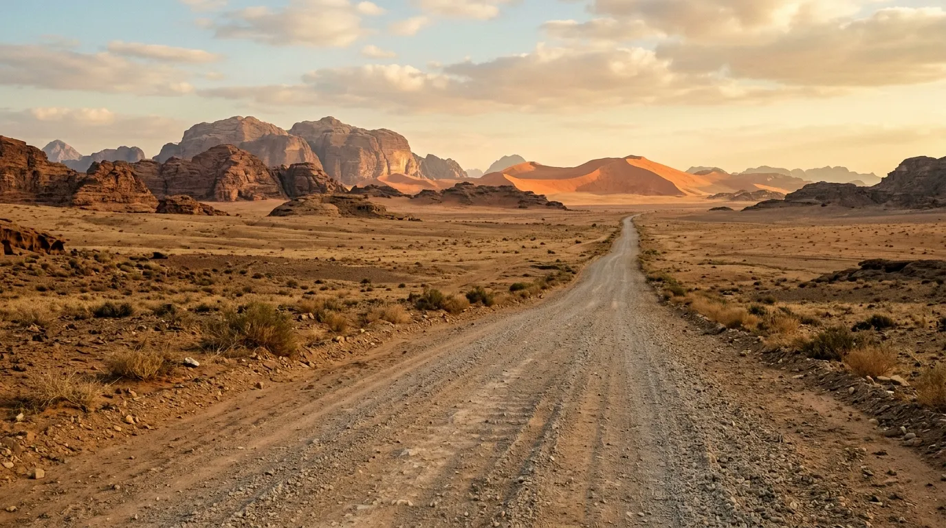
The D826: Aus to Sesriem
The D826 is the adventure option. It branches northwest from the B4 highway near Aus (a small town between Luderitz and Keetmanshoop) and crosses approximately 280 km of desert to reach the Sesriem area. The surface varies from reasonable gravel to rough corrugated track, and the route passes through some of the most remote terrain accessible by vehicle in southern Namibia. Traffic is sparse — we saw three vehicles in 280 km — and services are nonexistent.
The D826 is not recommended for 2WD vehicles. The corrugation is severe in places, the sand patches are unpredictable, and a breakdown would leave you waiting for rescue in a location where rescue is not prompt. With a 4x4 and adequate preparation (full fuel, water, two spare tires), it is a rewarding alternative that provides a southern approach to the dunes through terrain that most visitors never see.
The Sossusvlei road: Sesriem to the dunes
The gate and the timing
The Sesriem gate opens at sunrise and closes at sunset. These times are posted at the gate and enforced. The reason for the sunrise opening is photographic as much as administrative: the dunes at Sossusvlei are at their most dramatic in the first and last hours of daylight, when the low-angle light creates shadows that define the dune ridges and the sand glows the deepest red. Being at the gate at sunrise — which means being in the queue ten minutes before sunrise — is the difference between seeing the dunes in optimal light and seeing them in the flat, washed-out light of midday.
Staying inside the park (at the NWR Sesriem campsite) allows you to enter the gate before outside visitors. The campsite gate opens earlier than the main gate — typically 45 minutes before sunrise. This head start is significant. We stayed at the campsite specifically for this advantage and were among the first vehicles on the road at 05:45 in winter.
NWR Sesriem campsite: approximately 480 NAD per site per night (27 USD). Book in advance through NWR. The campsite has ablution facilities, braai stands, and a swimming pool that feels improbable given the location.
The tarred road to the parking area
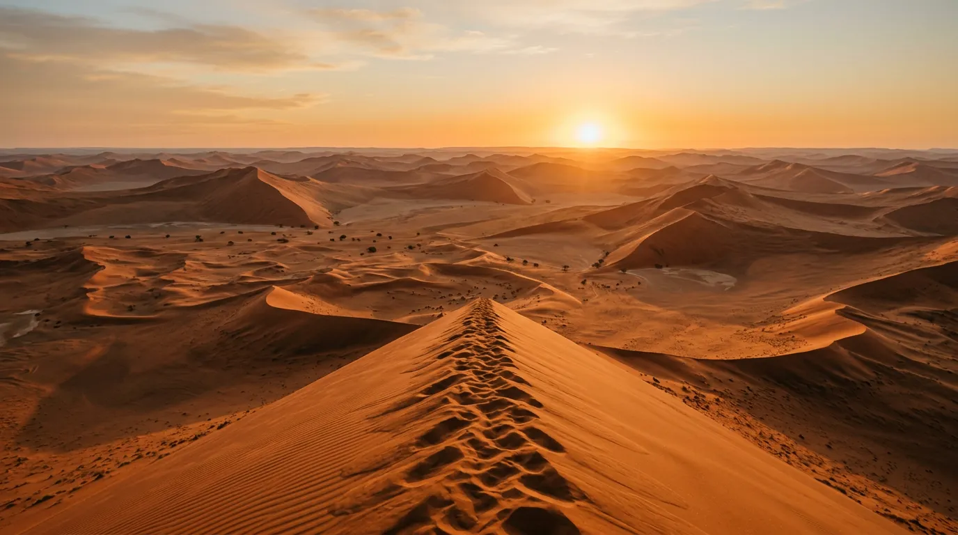
From the Sesriem gate, a tarred road runs 65 km southwest to the Sossusvlei parking area. The road is fast, smooth, and surrounded by scenery that improves dramatically with every kilometre — the dunes grow taller and closer until they line both sides of the road, an avenue of red sand that narrows toward Sossusvlei. Dune 45, so named because it is 45 km from the Sesriem gate, is the most accessible of the major dunes and the classic sunrise-climbing destination. A pull-off at its base provides parking, and a sand ridge leads to the summit at approximately 170 metres. The climb takes 20-45 minutes depending on fitness and the degree to which the sand resists your feet.
The last 5 km: the sand track to Deadvlei
At the end of the tarred road, a parking area marks the boundary between casual visit and commitment. Beyond the parking area, a sand track runs 5 km to the Deadvlei and Sossusvlei pans. This track is soft sand. Deep soft sand. 4x4-with-deflated-tires soft sand. The park operates a shuttle service (flat-bed trucks) for 2WD visitors, which is the honest solution to a problem that rental agencies prefer not to discuss: most rental agreements prohibit off-road driving, and the last 5 km to Deadvlei is definitively off-road.
If you have a 4x4, deflate to 16-18 PSI and drive. The track is well-worn and the route is obvious — follow the tire tracks through the sand, maintain momentum, and do not stop in the soft sections. The 5 km take about 15 minutes. At the end, a parking area provides the base for the walk to Deadvlei and Sossusvlei.
Sand driving protocol for the last 5 km:
| Step | Action |
|---|---|
| 1 | Deflate tires to 16-18 PSI at the tarred road parking area |
| 2 | Engage 4x4 (high range is usually sufficient) |
| 3 | Follow existing tracks — they indicate the firmest sand |
| 4 | Maintain steady speed (25-35 km/h). Do not stop. |
| 5 | If you feel the vehicle slowing, accelerate gently — do not brake |
| 6 | At the Deadvlei parking area, park on firm ground |
| 7 | Re-inflate tires before returning to the tarred road |
Deadvlei
From the parking area, a 1 km walk through deep sand leads to Deadvlei. The pan is a flat, white clay surface surrounded by dunes that rise over 300 metres. On the pan floor, dead camel thorn trees — killed approximately 900 years ago when the climate shifted and the water source that sustained them dried up — stand as black silhouettes against the white clay and the red dunes. The trees are dead. They have not decomposed because the climate is too dry for the bacteria that would normally break down wood. They just stand there, and they have been standing there since approximately the year 1100.
The visual is extraordinary. The contrast — white clay, black trees, red dunes, blue sky — creates a composition so graphic that it looks artificial. It is not. It is 900 years of aridity preserving a moment when a stand of trees died and nothing subsequently had the moisture or the microorganisms to remove them. Geology as installation art.
Practical logistics
Fuel
| Location | Distance to Sesriem | Notes |
|---|---|---|
| Walvis Bay | 350 km (C14) | Full service, major town |
| Solitaire | 80 km (C14/C24) | Fuel + bakery. Open daily. |
| Sesriem | 0 km | Small fuel pump at NWR campsite |
| Maltahohe | 120 km (C19/C24) | Small town, fuel available |
| Windhoek | 380 km (C19) | Full service |
Fuel consumption on the C14: approximately 11-13L/100km on gravel. On 350 km from Walvis Bay, expect 40-45 litres. A full 80L tank provides comfortable margin, but stopping at Solitaire is recommended regardless — for the fuel gauge if not the pie.
Accommodation options
| Option | Location | Type | Cost (approx.) | Advantage |
|---|---|---|---|---|
| NWR Sesriem campsite | Inside park | Campsite | 480 NAD/site | Early gate access |
| Sesriem Lodge | Outside park | Lodge | 2,500 NAD/person | Comfort, restaurant |
| Sossus Dune Lodge | Inside park (NWR) | Lodge | 4,500 NAD/person | Inside park, early access |
| Solitaire | 80 km north | Guesthouses, camping | 300-800 NAD | Budget option, fuel |
| Desert Camp | Outside park | Tented camp | 1,500 NAD/person | Good value, pool |
The strategic calculation: staying inside the park (Sesriem campsite or Sossus Dune Lodge) gives you a 45-minute head start over outside accommodation. For photography, this is significant — first light at the dunes lasts about 30 minutes, and the difference between arriving at Deadvlei at 06:15 and 07:00 is the difference between having the pan to yourself and sharing it with 50 other visitors.
The return
The C14 can be driven in reverse (south to north, Sesriem to Walvis Bay) with the same driving conditions and the same scenery, but different light — the afternoon light heading north is gentler than the morning light heading south, and the Kuiseb Canyon is more dramatic in the late afternoon. Alternatively, the C19 east to Windhoek is faster and connects to the tarred highway network.
Seasonal considerations
Sossusvlei is a year-round destination, but conditions vary.
| Season | Temperature | Light quality | Crowds | Notes |
|---|---|---|---|---|
| Mar – May | 25-35°C day, 10-15°C night | Excellent warm light | Moderate | Our recommended season |
| Jun – Aug | 20-25°C day, 0-10°C night | Clear, hard shadows | High season | Cold mornings at the dunes |
| Sep – Nov | 25-35°C day, 10-20°C night | Good | Moderate | Warming up |
| Dec – Feb | 35-40°C day, 15-25°C night | Harsh midday light | Low | Very hot, afternoon storms |
The best light for the dunes is the 30 minutes after sunrise and the 30 minutes before sunset. The low angle creates maximum contrast between the lit and shadowed faces of the dunes, and the colour is most saturated. Midday light washes out the colour and flattens the depth. Plan your visit around the light.
Getting there and getting out
From Walvis Bay (C14): 350 km, 5-6 hours. Most scenic approach.
From Windhoek (C19): 380 km, 5 hours. Fastest approach.
From Luderitz/Aus (D826): 280 km, 5-6 hours. Most remote approach.
Sossusvlei fits into a broader Namibia circuit. From here, the Skeleton Coast is accessible via the C14 north to Walvis Bay and then the coast road. Damaraland is a day’s drive north via Solitaire and Windhoek. And for a cross-border extension, South Africa’s Richtersveld is accessible via the B4 from Aus to the Sendelingsdrif border crossing — a route that takes you from Namibia’s highest dunes to South Africa’s oldest rocks in about two days of driving.
The honest summary
Sossusvlei is the one place in Namibia that everyone visits, and it deserves the traffic. The dunes are as extraordinary as the photographs suggest, and Deadvlei is one of those rare landscapes that lives up to its own mythology. But this guide is about the approach rather than the destination, and the approach — particularly the C14 from Walvis Bay — deserves recognition as a drive in its own right. Two hundred kilometres of gravel highway through the Namib Desert, past the Kuiseb Canyon, through terrain that has looked approximately the same for 55 million years, with zero traffic and nothing on the radio and the fuel gauge doing its slow arithmetic — this is desert driving at its most essential. No obstacles, no technical challenge, no river crossings or switchbacks. Just distance, and the road, and the desert on either side doing nothing and being everything.
Bring fuel. Bring water. Arrive at the gate before sunrise.