Transalpina
The Transalpina is the road the Transfagarasan would be if it had not been on television. The DN67C crosses the Parang Mountains — the second-highest range in Romania — peaking at 2,145 metres, which makes it 100 metres higher than the Transfagarasan summit. The views are equivalent. The engineering is similar. The traffic is a fraction. On the August weekday we drove it, we counted 14 vehicles between the summit and Novaci. On the Transfagarasan the previous day, we had lost count before the first hairpin.
The road was built as a military route in the 1930s and served as a strategic connection between Transylvania and Oltenia during WWII. For decades after the war, it remained unpaved and little-used. The current paved surface dates from the 2000s and remains a work in progress — some sections are smooth asphalt, others are patchy, and the seasonal gravel extensions at the summit have a habit of being either recently graded or recently abandoned, depending on the year.
This unevenness is the Transalpina’s appeal. The Transfagarasan is finished — it is a polished road that delivers a polished experience. The Transalpina still has edges. The pavement ends and continues as gravel. The gravel ends and continues as grass. The grass ends and you are on a highland plateau at 2,100 metres, surrounded by rocks and sheep, wondering when you left the road and whether the concept still applies.
The paved road
From the north: Sebes approach
The northern approach starts near Sebes in the Mures Valley and climbs south through forest and pasture. The road is paved throughout, though surface quality varies from good asphalt to patched concrete. The climb is gradual — the Transalpina gains altitude over a longer distance than the Transfagarasan, which makes it less dramatic switchback-by-switchback but more immersive overall. The forest transitions from broadleaf at lower elevations to spruce at mid-altitude to the alpine zone above 1,800 metres, and the progression is gradual enough that you feel the landscape changing rather than having it jump at you through hairpin turns.
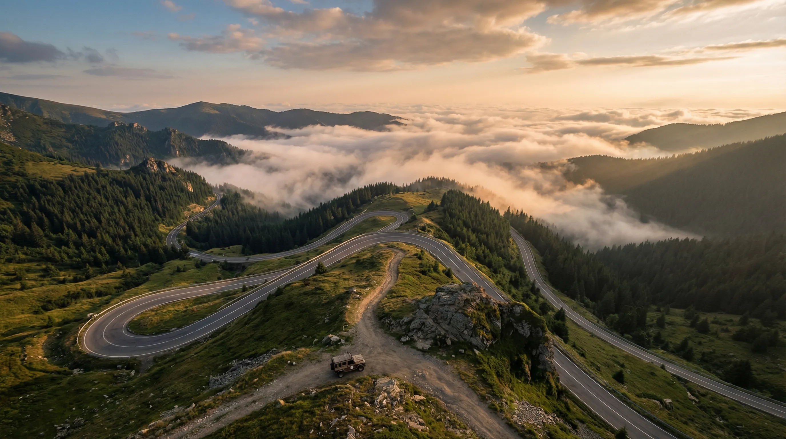
The summit section (1,800m – 2,145m)
Above the treeline, the Transalpina enters a landscape that looks more like Iceland or the Scottish Highlands than the Balkans. Bare grass, exposed rock, no trees, and a wind that makes vehicle doors difficult to manage. The road surface at the summit is asphalt, but it is thin asphalt over a mountain that clearly would prefer not to have a road on it — frost heaves, cracks, and sections where the surface has dissolved back into the gravel underneath.
The summit point is marked by a concrete post at 2,145 metres. There is a small parking area. The views are panoramic: the Parang range extends east and west, the Retezat Mountains are visible to the southwest, and on clear days, the Fagaras range (home of the Transfagarasan) is a wall of peaks to the east. The air is thin enough to notice if you exert yourself and cold enough for a jacket in any month.
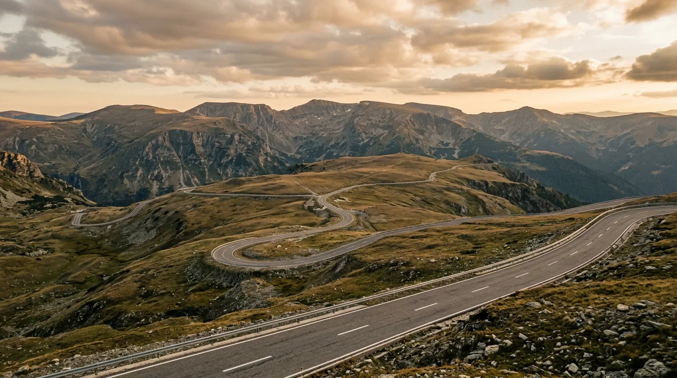
From the south: Novaci approach
The Novaci approach is the more scenic of the two directions and the one we recommend for first-time drivers. From Novaci — a small town in the Jiu Valley — the DN67C climbs through a series of gorges and hanging valleys. The road passes through Ranca, a ski resort at 1,600 metres that operates year-round as a mountain base. Ranca has fuel, restaurants, basic accommodation, and the last reliable supplies before the summit.
Above Ranca, the road climbs through the final forest belt and emerges onto the summit plateau. The transition is abrupt — one moment you are in dense spruce, the next you are on bare grass with the sky occupying most of your field of vision. The pavement condition on this section is better than the northern side, with several recently resurfaced stretches.
The unpaved extensions
Eastern summit extension
From a junction approximately 1 km east of the summit marker (45.3417 degrees N, 23.7250 degrees E), a gravel track extends east along the ridgeline for approximately 8 km. The surface is compacted gravel with sections of exposed rock — reasonable for a high-clearance 2WD in dry conditions, though a 4x4 is more comfortable. The track follows the crest of the Parang range at elevations between 1,900 and 2,100 metres, with views into the valleys on both sides.
The track ends at a shepherd pasture — a high-altitude meadow with stone shelters and a spring. In summer, shepherds and their flocks occupy the pasture, and the scene has not changed materially since before the road existed. The spring provides the only reliable water between Ranca and Sebes.
This extension is the Transalpina’s signature off-road detour and the one we most recommend. It is short enough to be manageable, scenic enough to justify the rougher surface, and high enough that the landscape has a genuinely alpine character — wildflowers, marmots, and the occasional golden eagle above.
Obarsie Lotrului track
A more ambitious option leaves the main road approximately 15 km south of the summit (45.3167 degrees N, 23.8500 degrees E) and follows a seasonal track east toward the Lotru Valley. This is a forestry road that was once maintained for logging access and has since been partially reclaimed by the forest. The surface varies from reasonable gravel to muddy track with encroaching vegetation, and the distance to Obarsie Lotrului settlement is approximately 25 km one-way.
Obarsie Lotrului is a tiny settlement at the head of the Lotru Valley — a handful of houses and a hydroelectric facility, accessible by road from the east but by this track from the west. Driving the track connects the Transalpina to the Lotru Valley in a way that feels like crossing between worlds — the open alpine summit gives way to dense spruce forest, river crossings, and a sense of isolation that the main road never provides.
This track requires a 4x4. The stream crossings (three, ranging from 15-30 cm in normal conditions) and the mud sections after rain make it inappropriate for 2WD. We drove it in the Duster 4x4 and found it the most enjoyable driving of our Transalpina visit — slow, technical enough to engage without threatening, and deeply atmospheric.
Western extensions toward Retezat
West of the summit, unmarked tracks branch toward the Retezat Mountains. We explored two of these, each approximately 5 km long, and found them to be fading pastoral tracks — passable in a 4x4 but ending at meadows rather than destinations. They are worth exploring if you have time, but they are appetizers rather than meals. The Retezat Mountains themselves, which contain Romania’s first national park, are more rewarding for hiking than driving.
Practical information
| Item | Detail |
|---|---|
| Total distance (paved + extensions) | ~130 km paved, +8-25 km unpaved |
| Driving time | 4-6 hours for the full pass, add 2-3 hours for extensions |
| Fuel | Novaci (south), Sebes (north), Ranca (midpoint, limited). |
| Water | 2L per person. Spring at the eastern extension shepherd pasture. |
| Season | Main road: June to October. Extensions: July to September. |
| Mobile coverage | Good in towns. Intermittent at summit. None on extensions. |
| Accommodation | Ranca: ski hotels and pensions, 25-60 EUR/night. Novaci and Sebes: budget options. |
| Tolls/permits | None. |
Driving itinerary
Morning: Depart Novaci at 07:00. Drive to summit via Ranca (fuel stop). Explore the eastern summit extension on gravel. Return to summit point for a break.
Midday: Optionally drive the Obarsie Lotrului track (add 3-4 hours for the round trip). Or continue north toward Sebes.
Afternoon: Descend to Sebes and either continue to Sibiu (useful base for the Transfagarasan) or return south to Novaci.
For a multi-day Carpathian itinerary: drive the Transalpina on day 1, the Transfagarasan on day 2, and the Carpathian Forest Tracks near Brasov on day 3. The three routes are 2-3 hours apart on paved roads and collectively cover the full range of Romanian mountain driving.
Perspective
The Transalpina is the better road for people who dislike crowds. It reaches the same altitudes, delivers the same views, and provides the same mountain-road driving experience as the Transfagarasan, but without the tour bus traffic and the photography drones. Its unpaved extensions add a dimension of exploration that the more polished Transfagarasan mostly lacks.
If you can only drive one Romanian mountain pass, drive the Transfagarasan — it is the more dramatic road and its reputation is earned. But if you can drive two, the Transalpina should be the second. And if you are the kind of driver who leaves the pavement on purpose, the Transalpina’s gravel extensions make it the more interesting of the two.
Return to the Romania hub for the full country overview.