Carpathian Forest Tracks
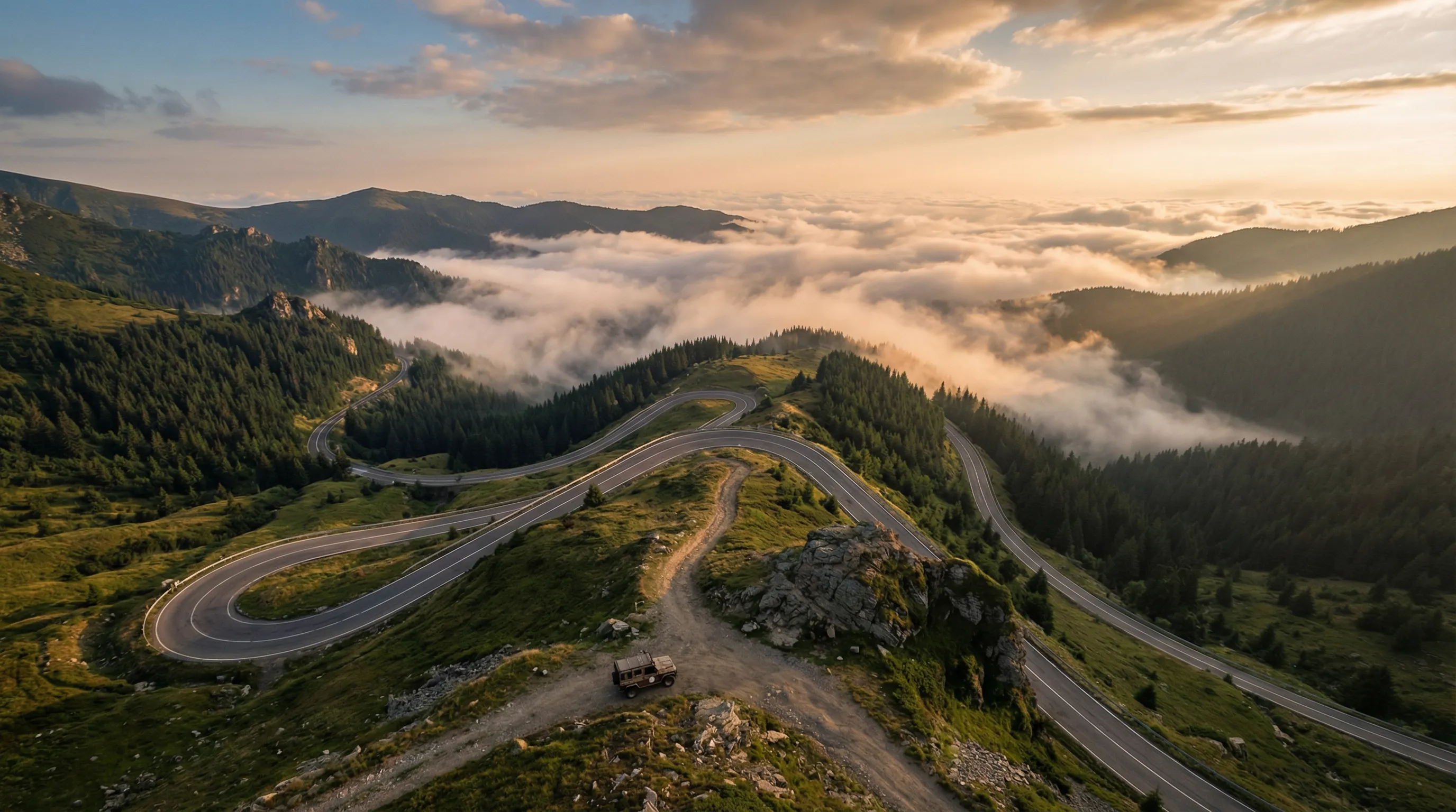
The forest is the thing. Romania’s mountain passes get the attention — the Transfagarasan and Transalpina are legitimately great roads — but the Carpathians are fundamentally a forest ecosystem, and the forestry tracks that wind through the old-growth beech and spruce below the treeline are where Romania’s off-road character is most distinct. These are not mountain roads. They are forest roads. The differences matter.
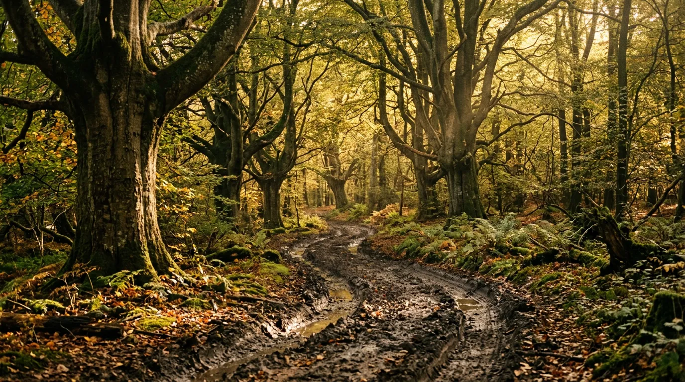
Mountain roads are about altitude, exposure, and views. Forest roads are about enclosure, softness, and what is around the next bend. On a mountain pass, you see everything for kilometres. On a forest track, you see 50 metres ahead and the rest is green wall. The surface is not rock or gravel — it is earth, organic and alive, and it behaves differently when wet. The gradients are moderate because the terrain is rolling rather than Alpine. The hazards are not cliffs but mud bogs, stream crossings, and a bear standing in the track with the unhurried body language of an animal that knows it outweighs your vehicle.
We drove approximately 80 km of forest tracks in the southern Carpathians between Brasov and the Fagaras range, spread across two areas: the forests south of Brasov toward Piatra Craiului, and the beech forests of the Fagaras foothills west of Curtea de Arges. The driving is not technically difficult — the gradients are gentle, the surfaces are soft, and the stream crossings are shallow. What makes it memorable is the atmosphere: dense, green, humming with life, and punctuated by moments of sudden opening when a clearing appears and a limestone ridge fills the sky.
The forest road network
Romania’s Carpathian forests are crisscrossed by logging roads — thousands of kilometres of track built to extract timber and maintained (or not) by the forestry services. The network is dense, and on OsmAnd it looks like capillaries branching from the arterial paved roads into the forest interior. Not all of these tracks are accessible — some are gated, some are actively used by heavy machinery, and some have deteriorated beyond vehicle passage. The ones we drove are publicly accessible, currently passable, and interesting enough to recommend.
Area 1: Brasov to Piatra Craiului (south of Brasov)
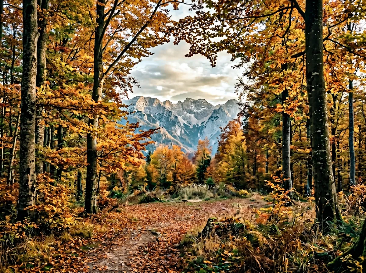
The most accessible forest driving from Brasov. From the village of Zarnesti — 25 km southwest of Brasov on paved road — forestry tracks head south and west into the beech forest below the Piatra Craiului ridge, a dramatic limestone wall that rises to 2,238 metres and is visible from the forest tracks in every clearing.
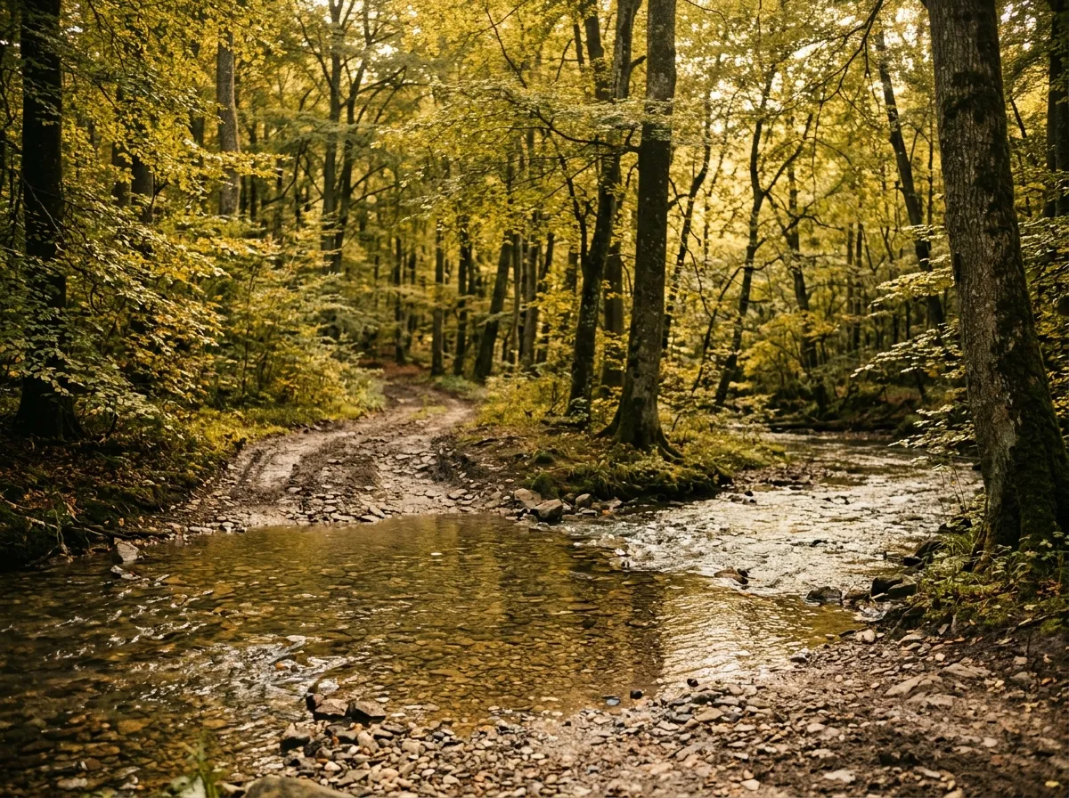
Zarnesti forest loop (35 km): From Zarnesti centre, a maintained forestry road heads south along the Barsau Valley for 8 km before branching into the forest. We followed the western branch for 15 km through beech forest, crossing three streams (all under 20 cm, gravel bottoms, straightforward) and passing through several clearings with views of Piatra Craiului. The track loops back to the Barsau Valley road via a parallel route through denser forest. Total loop: approximately 35 km. Driving time: 3-4 hours.
The surface is forest earth — compacted by logging traffic into a usable track, but soft enough to deform under a vehicle’s weight after rain. In dry summer conditions, a Dacia Duster 4x4 handles it comfortably. After a day of rain, the same track becomes a different proposition — the earth absorbs water like a sponge and the ruts fill with brown water that hides the depth. We drove this loop once in dry conditions (no issues) and once after 24 hours of rain (three occasions where the Duster was working hard and one where we questioned our life choices).
Piatra Craiului viewpoint track (12 km one-way): From the western branch of the loop, a side track climbs south toward the Piatra Craiului ridge. This track is steeper than the loop — gaining about 400 metres over 6 km through spruce forest — and ends at a clearing at approximately 1,300 metres with an unobstructed view of the limestone ridge. The approach is 4x4-only: steep enough for the gradient to matter and muddy enough to make traction critical. The viewpoint is worth the effort. Piatra Craiului is one of Romania’s most striking geological features, and seeing it from below, framed by spruce forest, is a different experience from the distant views available from the paved roads.
Area 2: Fagaras foothills (west of Curtea de Arges)
The forests on the northern flanks of the Fagaras range are denser and older than those near Brasov. Some sections contain genuine old-growth beech — trees that are 200-300 years old, with trunks thick enough to hide a vehicle behind and canopies that create a cathedral effect, the light filtering through layers of green in columns.
Fagaras forest traverse (35 km): From the village of Arpasu de Sus — approximately 40 km west of Curtea de Arges on paved road — a forestry road heads south into the beech forest. The first 10 km are maintained gravel (forestry trucks use this section regularly). Beyond the logging landing at km 10, the track narrows and the surface transitions to forest earth. The next 25 km traverse the foothills at 800-1,200 metres elevation, crossing four streams and passing through alternating beech forest and clearings.
This is the more atmospheric of our two forest areas. The old-growth sections are genuinely impressive — the trees are massive, the canopy is continuous, and the undergrowth is sparse enough that you can see deep into the forest from the track. On our morning drive (departing at 06:00), we saw deer in three separate clearings and heard something large moving through the undergrowth that we chose to believe was a deer as well.
The track ends at a junction with a maintained forestry road that connects back to the paved network via a valley to the east. The loop — Arpasu de Sus to the junction and back via the valley road — is approximately 80 km and takes a full day with stops.
Bears
Romania’s brown bear population is the largest in Europe outside Russia — approximately 7,000 animals, concentrated in the Carpathian forests. The forests we are recommending you drive through are bear habitat. Encounters are not guaranteed but they are not rare. We saw bears on two of our four days of forest driving — once a large adult crossing the track 100 metres ahead (we stopped and watched from the vehicle for two minutes until it walked into the trees), and once a mother with two cubs visible from a clearing at approximately 200 metres distance.
What to do when you see a bear
From the vehicle (the normal case):
- Stop the vehicle. Turn off the engine.
- Stay inside. Do not open the door, the window, or the sunroof.
- Watch and enjoy. Bears that see a stationary vehicle generally ignore it.
- Do not honk. Do not rev the engine. Do not try to get closer.
- After the bear moves away, wait 2-3 minutes before driving on.
On foot outside the vehicle (fuel stop, tire check, etc.):
- Do not run. Running triggers a pursuit response.
- Back away slowly toward the vehicle. Speak in a calm, low voice.
- Make yourself appear large (raise arms, open jacket).
- If the bear charges: most charges are bluffs. Stand your ground. If contact occurs, play dead (face down, hands behind neck). In the extremely rare case of a predatory attack (the bear is stalking you, not defending territory), fight back.
The statistical risk is low. Bears in the Carpathians are generally not interested in people — they want berries, grubs, and beech nuts. But the risk is non-zero, and respecting it is part of driving in these forests.
Camp and food hygiene
If you stop for a meal on the tracks: eat inside the vehicle. Do not leave food outside the vehicle. Do not throw food waste into the forest. Take all waste with you. Bears have learned to associate human presence with food, and a granola bar wrapper on the ground is a training exercise for a bear that will eventually approach a vehicle.
Vehicle and conditions
A 4x4 with all-terrain tires is the recommended setup. The Dacia Duster 4x4 with factory tires is adequate in dry conditions but marginal in mud — the factory highway tires do not grip well on wet earth. If you are renting a Duster for forest driving, check the tire type. All-terrain tires make a significant difference.
Ground clearance matters for the stream crossings. All the fords we drove were under 30 cm in normal summer conditions, but the entry and exit banks can be soft and carved into ruts by previous vehicles. A vehicle with 200 mm of clearance will handle them. A sedan will not.
Tire pressure: we dropped to 1.6 bar on the forest tracks for better grip on soft surfaces. Re-inflate before returning to pavement.
Practical details
| Item | Detail |
|---|---|
| Total distance | ~80 km (both areas combined) |
| Driving time | 6-8 hours for both areas (full day) |
| Fuel | Brasov, Zarnesti, Curtea de Arges. No fuel on forest tracks. |
| Water | 3L per person. Stream water requires filtering. |
| Season | May through October. Mud season extends into June. Autumn colours peak in October. |
| Mobile coverage | None on most forest tracks. Good in Brasov and Zarnesti. |
| Accommodation | Brasov: full range. Zarnesti: pensions from 20-40 EUR. Arpasu de Sus: limited. |
| Forestry access | Check with Brasov forestry office for any current closures. |
Timing
The forest tracks work at any time of day, but dawn and dusk are the best hours for wildlife and the worst for visibility on the narrow tracks. Our compromise: depart at 06:00 for the first hour of wildlife viewing, then drive the technical sections from 08:00-16:00 when the light is good.
October is the best month if you can arrange it. The beech forests turn colour in early October and the spectacle lasts about three weeks. The tracks are framed by gold and copper canopy, the light is warm and low, and the tourist season has ended. The mud risk is higher (autumn rain) but the visual reward is extraordinary.
Connections
The Carpathian Forest Tracks are a natural complement to the mountain passes. Drive the Transfagarasan for altitude and views, then drop into the forest tracks for a different character of driving. The Transalpina is 3 hours west and provides alpine gravel extensions that contrast with the forest environment.
For forest driving outside Romania, the closest equivalent in our catalogue is the Sutjeska National Park Trails in Bosnia — similar old-growth forest character, though with different tree species and fewer bears.
Return to the Romania hub for the full country overview.