Transfagarasan
The Transfagarasan is the most famous mountain road in Romania and, depending on your metric, one of the most famous in Europe. The DN7C crosses the Fagaras Mountains — the highest range in the Romanian Carpathians — from the town of Cartisoara in Transylvania to Curtea de Arges in Wallachia, climbing to 2,042 metres at Balea Lake via a sequence of hairpin switchbacks that has been photographed, filmed, and driven by every automotive journalist and tourist with a steering wheel.
Jeremy Clarkson called it the best road in the world on Top Gear in 2009. Since then, the road has not changed much but the traffic has. On a summer weekend, the northern switchbacks carry a procession of campervans, rental Dacias, Bucharest Porsches, and adventure motorcyclists that makes the road feel less like a mountain pass and more like a slow parade. The views remain stunning. The driving experience on a busy Saturday is less so.
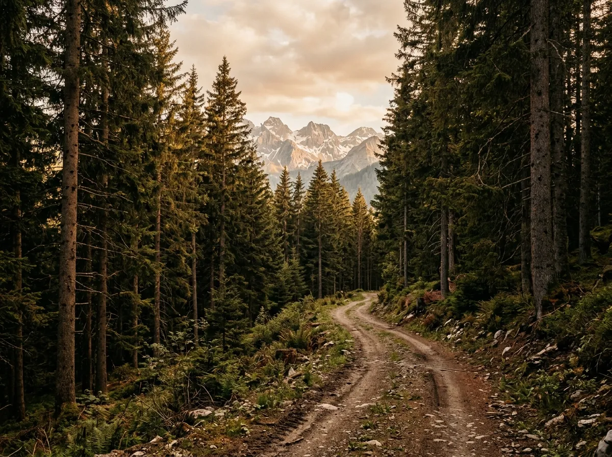
We are writing about the Transfagarasan not because of the paved road — which, while excellent, is covered by every travel website in existence — but because of what branches off it. The Fagaras Mountains are laced with forestry tracks that leave the DN7C at various altitudes and lead to places the pavement never reaches: shepherd pastures above the treeline, glacial lakes without road access, forest clearings where the only tire tracks are from the last logging operation. These side tracks are the off-road component, and they transform the Transfagarasan from a scenic drive into a multi-day exploration.
The main road: a brief orientation
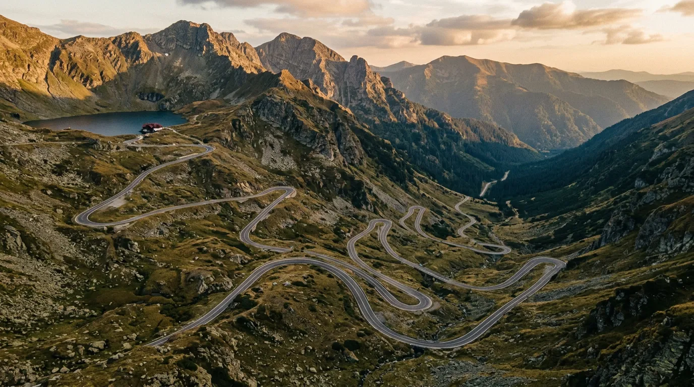
The DN7C runs approximately 150 km from north to south, though only the central 90 km is mountain road. The approaches from both Cartisoara and Curtea de Arges are valley roads through gentle terrain. The mountain section — the part that earns the reputation — begins at approximately 800 metres and climbs to 2,042 metres at Balea Lake.
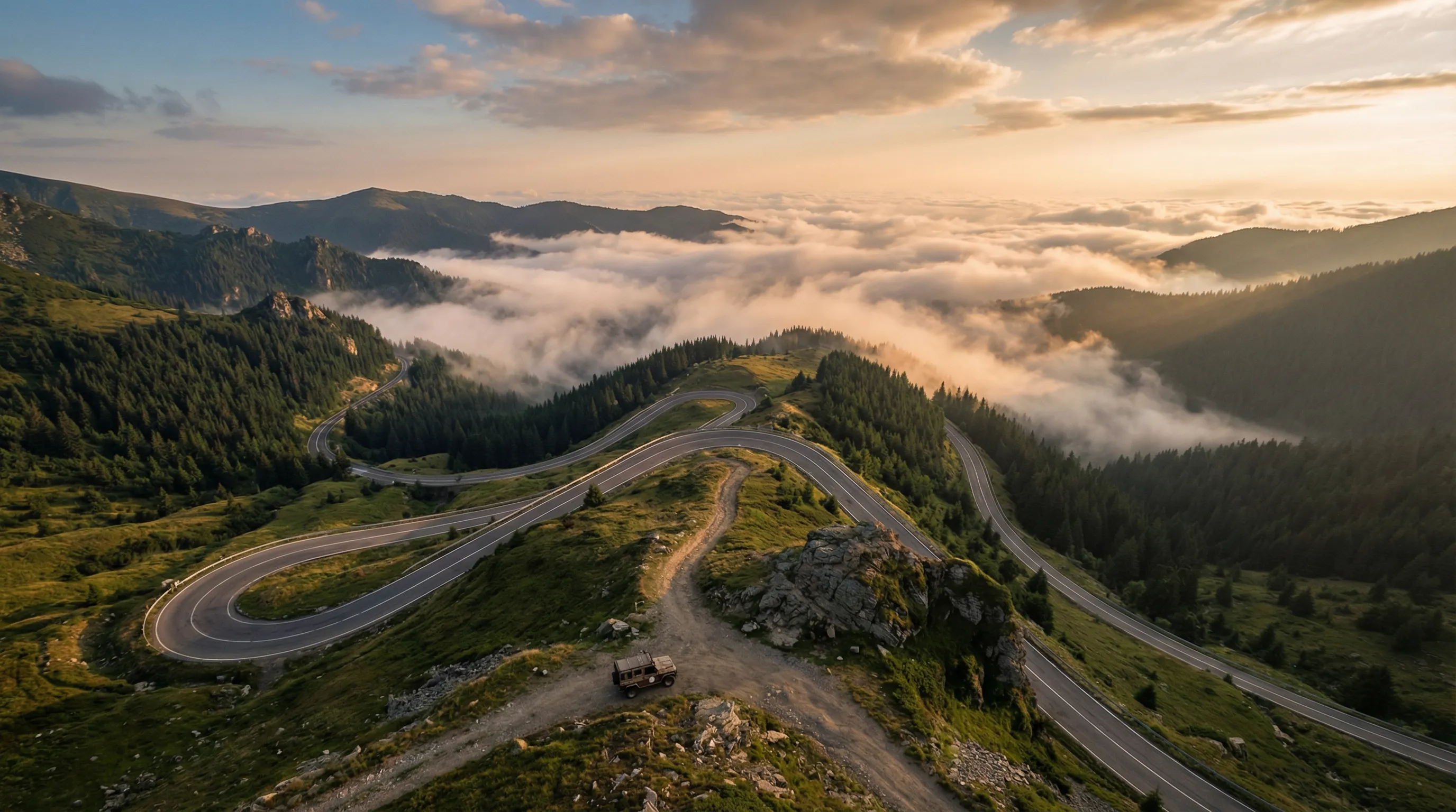
From the north (Cartisoara approach): The road enters the Fagaras range through a forested valley, then emerges above the treeline at approximately 1,800 metres and begins the famous hairpin section. The northern switchbacks descend approximately 800 metres in 8 km through 15 hairpin turns, which means they ascend the same way coming from this direction. This is the most dramatic section of the road and the best introduction to what the Transfagarasan offers.
From the south (Curtea de Arges approach): The road passes the Vidraru Dam — a 166-metre concrete arch dam holding back an artificial lake — and climbs through dense forest to the summit. The southern approach is less dramatic but longer, and the Vidraru Dam area provides the best access to the forest side-tracks.
The summit (Balea Lake): A glacial lake at 2,042 metres surrounded by bare rock and alpine grass. There is a cable car station, a hotel (expensive), a chalet (less expensive), and a parking area that on weekends resembles a car show. The views are comprehensive — the Fagaras ridge extends in both directions, and on clear days you can see the Transylvanian plateau to the north and the Wallachian plain to the south.
When to drive it
The pass opens when the snow clears from the summit section, typically in late June, and closes when the first sustained snowfall blocks it, typically in late October. Check the Romanian road authority website (CNAIR) or ask locally — the dates vary by year.
For the paved road with minimal traffic: weekday mornings, particularly in September or early October. For the side tracks: any day works, because nobody else is on them.
The side tracks
Vidraru Dam area tracks (southern approach)
The Vidraru Dam sits at approximately 800 metres elevation on the southern approach to the pass. The dam created an artificial lake that is ringed by forest, and the forestry roads that served the dam’s construction now provide access to the surrounding Fagaras forest.
From the dam parking area (45.3533 degrees N, 24.6283 degrees E), a gravel road heads east along the lake shore for approximately 12 km before terminating at a logging clearing. The surface is compacted gravel, well-maintained, and suitable for a 2WD with clearance. The drive is unremarkable in terrain terms but pleasant — the lake on one side, dense beech forest on the other, and the occasional glimpse of the high Fagaras peaks above the treeline.
A more interesting option branches north from the lake road at km 5 and climbs into the forest toward a shepherd pasture at approximately 1,400 metres. This track is narrower, steeper, and muddier — a 4x4 is recommended, particularly for the final 3 km where the surface transitions from gravel to forest earth. The pasture at the top provides open views of the Fagaras ridge and is reliably empty of other vehicles.
Northern flank tracks (Cartisoara side)
The northern approach to the Transfagarasan passes through several villages in the Olt Valley. From these villages — particularly Cartisoara and Avrig — forestry roads climb south into the Fagaras range. The tracks are longer and higher than the Vidraru area options, and some reach the alpine zone above 1,800 metres.
The most accessible is a track from Cartisoara that follows a tributary valley south for 15 km to a clearing at approximately 1,500 metres. The first 8 km are maintained gravel. The remaining 7 km are ungraded forest track: narrower, rougher, with two stream crossings that require clearance (20-30 cm of water over gravel bottom). A Dacia Duster 4x4 handles it. A 2WD Duster would struggle at the stream crossings.
A longer option — approximately 25 km one-way — leaves the DN7C at 1,200 metres altitude (approximately 6 km south of the Cartisoara junction on the paved road) and follows a forestry road east into the Fagaras range. This track climbs to 1,700 metres before descending into a parallel valley. It is a full half-day detour and requires a 4x4. The terrain is classic Carpathian forest — beech transitioning to spruce, streams everywhere, and the possibility of bear encounters that increases with distance from the main road.
Alpine extensions above the treeline
Above the treeline (approximately 1,800 metres in the Fagaras range), the landscape transitions from forest to alpine meadow and rock. Short tracks — remnants of military roads and shepherd access routes — extend from the DN7C into this terrain. Most are only 2-4 km long before they end at pastures or degrade into footpaths.
The most rewarding is a track that leaves the DN7C approximately 2 km north of Balea Lake and traverses a high ridge for 3 km to a viewpoint over a glacial cirque. The surface is rocky alpine terrain — exposed bedrock and grass — and the gradient is gentle. Any 4x4 can manage it. The destination is a ridgeline viewpoint that looks down into a cirque containing a small unnamed lake, with the main Fagaras ridge extending in both directions. It is one of the best viewpoints accessible by vehicle in the Romanian Carpathians.
Practical information
Day 1 itinerary (recommended)
| Time | Activity | Notes |
|---|---|---|
| 07:00 | Depart Cartisoara or Sibiu | Early start for empty roads |
| 08:00-10:00 | Northern approach and summit (Balea Lake) | Photos, coffee at chalet |
| 10:00-12:00 | Alpine extension track above treeline | 3 km side track to cirque viewpoint |
| 12:00-13:00 | Drive south to Vidraru Dam area | Descend on paved road |
| 13:00-16:00 | Vidraru forest tracks | Shepherd pasture track (4x4 needed) |
| 16:00-17:30 | Continue to Curtea de Arges | Fuel, accommodation, dinner |
Day 2 option
Return to the northern side via the DN7C and explore the Cartisoara forestry tracks. Or continue east toward Brasov and the Carpathian Forest Tracks for a different character of off-road.
Fuel and supplies
Curtea de Arges (south) and Cartisoara/Sibiu (north) are the fuel points. The summit area has no fuel. The longest gap from summit to fuel is approximately 60 km (to Curtea de Arges). Carry water and snacks — the summit chalet is expensive and the side tracks have no services.
Accommodation
Sibiu and Curtea de Arges are the main base towns, each with a full range of hotels and guesthouses. Pensions (guesthouses) in the approach villages — Victoria, Cartisoara — are cheaper and closer to the mountain. Budget 25-50 EUR per night for a pension with breakfast.
Maps and navigation
OsmAnd is essential for the forestry side tracks — Google Maps shows the main DN7C but not the forest roads. Download the Romania offline map package before departure. The forestry tracks are generally well-mapped on OsmAnd, though surface quality descriptions should be treated as indicative rather than definitive.
Perspective
The Transfagarasan’s reputation as a driving road is deserved but narrow. The paved road is an excellent piece of mountain engineering that delivers views and switchbacks in abundance. Driven on a quiet weekday, it is a highlight of any European road trip. Driven on a summer weekend, it is a highlight with queues.
The side tracks are where the Transfagarasan becomes something more than a scenic drive. They are not difficult. They are not remote by the standards of our other routes. But they introduce the Carpathian forest — its density, its darkness, its wildlife, its mud — in a way that the polished surface of the DN7C cannot. If you are driving the Transfagarasan and your vehicle has any clearance at all, take at least one side track. The difference between the tourist road and the forest road 500 metres off it is the difference between watching a documentary about mountains and walking into one.
Return to the Romania hub for the full country overview. For more challenging forest driving, continue to the Carpathian Forest Tracks. For a higher, quieter mountain pass, drive the Transalpina.