Baviaanskloof
The gorge announced itself with a sound. Not the engine, which had been labouring quietly over gravel for the last hour, and not the wind, which the canyon walls had reduced to nothing. It was water — a low, continuous rush that we heard before we saw the first river crossing, maybe 200 metres ahead where the track dipped into a band of dark rock and disappeared beneath a shallow current that ran the full width of the road. We stopped. Checked the depth with a stick. Walked the crossing to feel the riverbed underfoot — gravel over rock, firm, no soft spots. Then we drove through at walking pace, water rising to mid-hub, and came out the other side into a landscape that looked exactly the same as the one we had left, except that the GPS now showed we were one crossing down with thirteen to go.
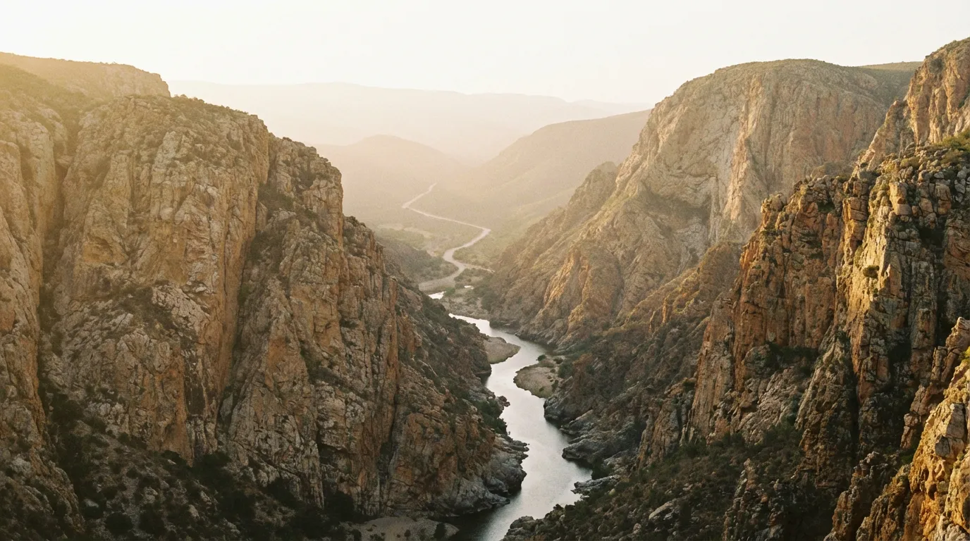
The Baviaanskloof Mega Reserve is a 200 km gorge running roughly east-west through the mountains of South Africa’s Eastern Cape. The name is Afrikaans for “Valley of the Baboons,” and the baboons are indeed present — we counted three separate troops over two days — but the defining feature is geological rather than biological. The gorge was carved by the Baviaanskloof River through folded sedimentary rock over millions of years, creating a passage that is narrow enough in places to feel enclosed and long enough to require genuine logistical planning. There are no shops, no fuel stations, no cell towers, and no alternative routes inside the reserve. You enter at one end and you exit at the other, and the 200 km between the two gates is whatever the river and the road decide it will be.
Route overview
The route runs between two gates: the Willowmore gate on the western end and the Patensie/Cambria gate on the eastern end. We drove westbound to eastbound, which is the more common direction and, in our experience, the better one — the road improves gradually as you move east, which means the most challenging sections come while you are fresh.
| Section | Distance | Terrain | Key features |
|---|---|---|---|
| Willowmore gate to Geelhoutbos | ~50 km | Rocky gravel, 3 river crossings | Initial descent into gorge, narrow sections |
| Geelhoutbos to Makkedaat Caves | ~45 km | Mixed gravel, 4 river crossings | Deepest part of gorge, best camping |
| Makkedaat Caves to Bergplaas | ~40 km | Gravel, 3 river crossings | Canyon opens slightly, indigenous forest |
| Bergplaas to Nieu-Bethesda turnoff | ~30 km | Improved gravel, 2 river crossings | Valley of Desolation side trip option |
| Nieu-Bethesda turnoff to Patensie gate | ~35 km | Good gravel, 2 river crossings | Widening valley, easier terrain |
Total distance: approximately 200 km. Total river crossings: 14. Driving time without stops: 8-10 hours. Recommended time: 2-3 days.
The 14 crossings are the defining logistical feature. In dry season (April to October), they range from ankle-deep to mid-wheel, and all are passable in a 4x4 with reasonable clearance. In wet season, several become waist-deep or worse, and after heavy rain, the river can rise to levels that make crossing suicidal. The gorge has no flood warning system. If it rained heavily in the mountains in the preceding 48 hours, reconsider your timing.
Day 1: Willowmore gate to Makkedaat Caves
The approach from Willowmore
Willowmore is a small Karoo town about 80 km south of Graaff-Reinet on the N9. It has fuel, basic supplies, and the unhurried atmosphere of a place where nothing has happened quickly in a long time. The town’s only visible concession to the off-road traffic passing through is a hand-painted sign at the fuel station that reads “Last Fuel Before Baviaanskloof.” This is accurate. Fill your tank. Fill your jerry cans. Buy water if you have not already. Then drive the 20 km of tarred road to the western gate.
At the gate, you register your vehicle and number of passengers. Entry is free. The gate attendant will ask how many days you plan to spend in the reserve and whether you have a campsite booking. They will also tell you the current state of the river crossings — this information is gold. Pay attention to it.
The first crossings
The track drops into the gorge within the first 5 km, and the transition is abrupt. The open Karoo landscape — flat, dry, infinite — gives way to rock walls that close in from both sides. The vegetation shifts from sparse scrub to subtropical bush. The temperature drops several degrees. And then the road meets the river.
Crossing protocol, which we refined over 14 repetitions:
- Stop before the crossing. Get out. Walk it. A crossing that looks 30 cm deep from the bank can be 60 cm deep in the middle where the current has scoured a channel.
- Check the riverbed. Gravel and rock are good. Sand is acceptable. Mud means the crossing has been disturbed recently, possibly by a vehicle that got stuck. Proceed with caution.
- Choose your line. The shallowest water is usually on the inside of any curve in the river. Look for where the current is slowest — that is where the riverbed is highest.
- Enter slowly, maintain momentum. First gear, low range. No stopping in the middle. Bow-wave should be visible but not dramatic — if water is splashing over the hood, you are going too fast.
- Exit and check. On the far bank, stop and listen to the engine. Check for water in places water should not be.
The first three crossings come in quick succession — within the first 30 km. They are also the shallowest, which makes them a useful tutorial. By crossing four, you will have developed a rhythm. By crossing eight, you will have stopped thinking about the process consciously and started thinking about the scenery instead, which is the point at which the gorge begins to reward the effort of getting there.
Geelhoutbos to Makkedaat
The gorge narrows dramatically between the third and seventh crossings. The rock walls rise to perhaps 300 metres on either side, close enough that the sky becomes a strip of blue between the ridges. The vegetation on the gorge floor is dense — yellowwood trees (geelhoutbos means “yellowwood forest”), stinkwood, ironwood, and species we could not identify but which grew at angles that suggested a permanent argument with gravity.
The road surface through this section is the roughest on the route: loose rock, exposed bedrock, and stretches of gravel that have been redistributed by flooding into patterns that favour no particular vehicle line. Average speed: 15-20 km/h. This is not a section to rush through, and not only because of the surface — the gorge is at its most dramatic here, and the river crossings at their most photogenic.
Makkedaat Caves
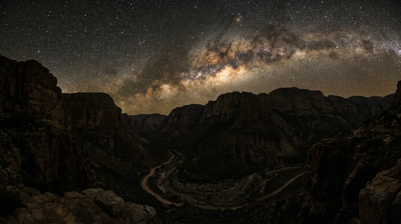
Makkedaat (33.5200° S, 24.6500° E) is a series of sandstone overhangs — not true caves but rock shelters, some of them large enough to park a vehicle under. The CapeNature campsite here consists of cleared areas under the overhangs with braai (barbecue) facilities and long-drop toilets. No electricity. No running water (the river is 50 metres away but is not potable). No cell signal. What there is, once the sun goes down, is the clearest night sky we have seen in South Africa. The gorge walls block all ambient light, and the Milky Way overhead is not the faint smudge you see from cities but a structural feature — a band of light bright enough to cast shadows.
Book Makkedaat through CapeNature. Seriously. This is not optional advice. The campsite has limited capacity, and in peak season (June to August, which is South African winter and the best time for the gorge), it fills up weeks in advance. We booked ours six weeks out and got the last available spot.
Cost: approximately 250 ZAR per site per night (about 14 USD at current exchange rates).
Day 2: Makkedaat to Patensie gate
The eastern gorge
East of Makkedaat, the gorge gradually opens. The rock walls recede, the valley floor widens, and the river crossings become shallower and more spread out. The road surface improves in parallel — still gravel, still unpaved, but graded more recently and with fewer of the rock ledges that characterize the western section. By the time you reach Bergplaas, approximately 135 km from the western gate, you are driving at 40-50 km/h on reasonable gravel rather than picking your way through rock at 15 km/h.
This section is where the indigenous forest becomes most impressive. The trees along the river are old — some of the yellowwoods are estimated at over 500 years — and they form a canopy that closes over the road in places, creating green tunnels that smell of damp earth and decomposing leaves. Keep an eye out for baboons, which are most active in the morning and treat the road as part of their territory. We rounded a corner to find a troop of perhaps thirty animals sitting in the road, regarding us with the polite disinterest of tenants who have been here longer than we have.
The Valley of Desolation side trip
At approximately 160 km, a signed turnoff leads north to Nieu-Bethesda and the Valley of Desolation viewpoint. The detour adds about 60 km round trip on gravel road, but if you have time, it is worth the diversion. The Valley of Desolation is a collection of dolerite pillars — volcanic rock columns, some over 100 metres tall — standing in a semi-circle above the Karoo plain. The viewpoint is accessible by a paved road from Graaff-Reinet, but approaching it from the Baviaanskloof side on gravel feels more appropriate to the landscape.
Nieu-Bethesda itself is a village of about 100 people, known primarily for the Owl House — the life’s work of artist Helen Martins, who filled her house and garden with concrete and glass sculptures. It is strange and compelling and completely unrelated to off-road driving, but we mention it because you will pass through and you will wonder what the signs are about.
The final crossings
The last two river crossings, between the Nieu-Bethesda turnoff and the Patensie gate, are the easiest on the route. The river is wide and shallow here, the bed is flat gravel, and the water barely reaches the wheel hubs. After thirteen crossings of increasing confidence, these feel like a formality. You splash through, climb a gentle rise, and the Patensie gate appears ahead — a simple boom gate with a register book and, beyond it, the first tarred road you have seen in 200 km.
The sensation of driving on tar after two days of gravel and river crossings is briefly disorienting. The smoothness feels unnatural. The speed feels excessive. This passes within about five minutes, at which point you will start thinking about your next meal and a hot shower, in that order.
Equipment checklist
What we carried, what we used, and what we wished we had.
| Item | Required | Notes |
|---|---|---|
| High-lift jack | Yes | Essential for river bank approaches where standard jack cannot reach |
| Recovery boards (pair) | Yes | Used once on a muddy river exit |
| 2 spare tires | Yes | We used one. Rock punctures are common. |
| Water (5L/person/day) | Yes | River water is not potable without treatment |
| Tow strap (5 tonne rated) | Yes | Did not use, but traffic is sparse enough that self-recovery matters |
| 20L fuel jerry can | Yes | 200 km gap between fuel stations |
| Tire repair kit | Yes | Plug kit + compressor for slow punctures |
| Basic tool kit | Yes | Wrenches, pliers, spare fuses, duct tape |
| Headlamp/torch per person | Yes | No electricity at Makkedaat |
| Firewood | Recommended | Collecting wood is prohibited in the reserve. Buy in Willowmore. |
| Water purification tablets | Recommended | Emergency backup if you run low |
Fuel consumption
Our vehicle (Toyota Fortuner, 2.8L diesel) consumed approximately 14L/100km through the gorge — higher than the highway average of 9L/100km due to the constant low-gear driving and river crossings. On a full 80L tank plus a 20L jerry can, we arrived at Patensie with roughly 30 litres remaining. A vehicle with a smaller tank or higher consumption will need to manage fuel more carefully.
River crossing reference
Because the crossings are the route’s defining challenge, here is a summary of conditions as we found them in May (mid dry season).
| Crossing | Approximate km | Depth (May) | Riverbed | Difficulty |
|---|---|---|---|---|
| 1 | 12 | 20 cm | Gravel | Easy |
| 2 | 18 | 25 cm | Rock | Easy |
| 3 | 28 | 30 cm | Gravel | Easy |
| 4 | 42 | 40 cm | Gravel/sand | Moderate |
| 5 | 51 | 35 cm | Rock | Moderate |
| 6 | 58 | 45 cm | Gravel | Moderate |
| 7 | 67 | 50 cm | Gravel/rock | Challenging |
| 8 | 82 | 40 cm | Rock | Moderate |
| 9 | 95 | 45 cm | Gravel | Moderate |
| 10 | 108 | 35 cm | Rock | Moderate |
| 11 | 125 | 30 cm | Gravel | Easy |
| 12 | 140 | 25 cm | Gravel | Easy |
| 13 | 172 | 20 cm | Gravel | Easy |
| 14 | 188 | 15 cm | Gravel | Easy |
Depths are approximate and vary significantly by season. After rain, add 20-50 cm to each figure. Crossing 7, at the deepest and narrowest point of the gorge, is the one most likely to become impassable after heavy rain. If crossing 7 is impassable, so are crossings 4-6, which means you are turning around.
Seasonal considerations
The Baviaanskloof is a dry-season route. This is not a suggestion — it is a statement about physics. The 14 river crossings that make the route interesting in April make it dangerous in December. The Eastern Cape summer (November to March) brings thunderstorms that can drop 50 mm of rain in an hour, and in a narrow gorge with no high ground, that rain has only one place to go.
| Month | Conditions | Recommendation |
|---|---|---|
| Jan – Mar | Wet season. River high, crossings dangerous. | Do not attempt |
| Apr – May | Dry season begins. Crossings receding. | Good conditions |
| Jun – Aug | Mid dry season. Lowest water levels. Cold nights. | Best conditions |
| Sep – Oct | Dry season ends. Crossings still manageable. | Good conditions |
| Nov – Dec | Rains return. Rising water levels. | Do not attempt |
Night temperatures in winter (June to August) drop to 2-5 degrees Celsius in the gorge. Bring warm sleeping gear for Makkedaat. The gorge walls block sunlight until mid-morning and lose it in mid-afternoon, which means the temperature window for comfort is narrower than the calendar might suggest.
Getting there and getting out
From Cape Town: 750 km to Willowmore via the N12 and N9. About 8 hours of driving. Break the trip in Graaff-Reinet or Oudtshoorn.
From Port Elizabeth / Gqeberha: 250 km to Patensie via the N2 and R332. About 3 hours. This is the closest major city to the eastern gate.
From Johannesburg: 950 km to Willowmore via the N1 and N9. About 10 hours. Consider breaking the trip in Graaff-Reinet.
The Baviaanskloof pairs well with Sani Pass if you are doing a broader South African off-road trip — the two routes are about 800 km apart, connected by the N2 coastal highway through some of the most scenic road driving in the country. The Richtersveld is a longer detour, 1,200 km to the northwest, but combines well if you are heading toward Namibia afterward.
The honest summary
The Baviaanskloof is not the most technical off-road route in South Africa. The river crossings, in dry season, are manageable. The road surface, while rough in places, does not demand expert driving. What makes it exceptional is the combination of distance, isolation, and scenery — 200 km through a gorge where the only evidence of the twenty-first century is the vehicle you are sitting in. No cell signal. No other traffic, on the day we drove it, for stretches of 50 km. No sound except the engine, the river, and the wind in the yellowwood trees.
We came out the eastern gate covered in dust with one flat tire, one bruised rocker panel, and a profound appreciation for whoever decided to grade a road through this gorge in the first place. The Baviaanskloof is not a wilderness route — it is a road, with gates and campsites and a grader that visits once a year. But for 200 km, it feels like one.