Richtersveld Loop
We arrived at the Sendelingsdrif gate at midday and the thermometer on the dashboard read 38 degrees Celsius. This was July — South African winter — and the park ranger who stamped our permit looked at the reading and said, without particular alarm, that summer would be worse. In January, he said, the rocks radiate heat long after sunset and the ground temperature exceeds 50 degrees. He said this in the same tone you might use to describe a mild inconvenience, like a traffic light being out. The Richtersveld normalizes extremes. It has been doing so for about two billion years, which is how old the rocks are, and it will continue to do so long after the road we were about to drive has been reclaimed by the desert.
The Richtersveld Transfrontier Park covers approximately 1,600 square kilometres of the northernmost corner of South Africa’s Northern Cape province, along the Orange River border with Namibia. The landscape is succulent Karoo desert — bare rock, sparse vegetation adapted to almost no rainfall, and geological formations that have been weathered into shapes no committee would approve. The park contains the richest concentration of succulent plant species on Earth, including the Halfmens tree (Pachypodium namaquanum), a plant that grows up to 4 metres tall, always leans toward the north, and looks precisely like a person standing on a hillside, which is both its common name and the reason early travellers in this region occasionally greeted vegetation.
The loop road through the park covers approximately 160 km of gravel track, connecting four campsites and passing through terrain that varies from rocky mountain passes to Orange River floodplain. We drove it in two and a half days, which is the minimum for appreciating what this landscape offers. Three days is better. Rushing through the Richtersveld defeats the purpose — the interest is not in the driving, which is moderate, but in the looking, which requires stopping the vehicle and standing in silence while the desert does its work on your sense of scale.
Route overview
The loop can be driven in either direction. We drove clockwise, starting from Sendelingsdrif on the Orange River and climbing south into the mountains before descending back to the river at De Hoop. This direction puts the most spectacular scenery — the mountain passes and Halfmens forests — in the second half of the drive, which is psychologically satisfying.
| Section | Distance | Terrain | Key features |
|---|---|---|---|
| Sendelingsdrif gate to Potjiespram camp | ~30 km | River valley gravel, flat | Orange River views, mining heritage |
| Potjiespram to Tatasberg camp | ~45 km | Rocky mountain pass, steep sections | Highest point on loop, geological formations |
| Tatasberg to Halfmens viewpoint | ~25 km | Desert gravel, rocky | Endemic Halfmens tree forests |
| Halfmens viewpoint to De Hoop camp | ~30 km | Descending gravel, river approach | Orange River canyon, best campsite |
| De Hoop to Sendelingsdrif gate | ~30 km | River valley gravel, flat | Return along river |
Total: approximately 160 km. Driving time without stops: 6-8 hours. Recommended time: 2-3 days.
Day 1: Sendelingsdrif to Potjiespram
Getting to the gate
Sendelingsdrif is remote by any standard. The nearest town of consequence is Springbok, 250 km to the south on the N7 highway. Port Nolloth, a small fishing town on the Atlantic coast, is closer at 90 km but has limited supplies. From either, the approach is via gravel road through increasingly empty landscape. The last 40 km to the gate pass through the buffer zone of the park — already desert, already spectacular, already giving no indication that services of any kind exist within driving distance.
At the gate, you present your SANParks booking confirmation (book online, months in advance — this is not optional advice) and receive a permit. The ranger will brief you on road conditions, campsite rules, and the temperature forecast. Pay attention to the temperature forecast. If daytime highs are predicted above 42 degrees, consider adjusting your plans — vehicle overheating and human heat exhaustion are genuine risks, not theoretical ones.
The Orange River section
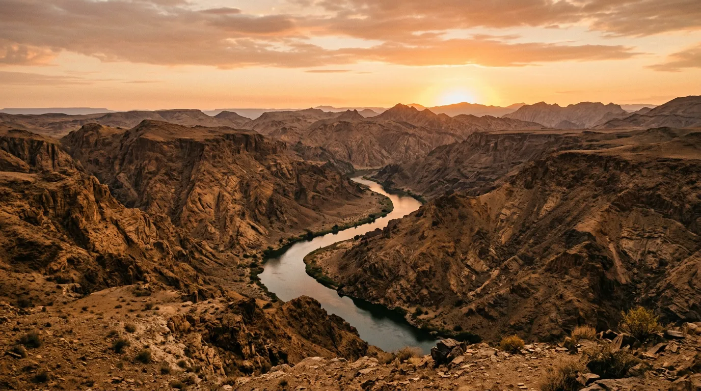
The first 30 km follow the Orange River eastward to Potjiespram camp. The road is flat, the surface is reasonable gravel, and the river provides a continuous band of green — reeds, acacias, and the occasional bird — against the brown moonscape on either side. The Orange River is South Africa’s longest river and the border with Namibia for this section of its course. The Namibian side looks identical to the South African side, which makes the border feel especially arbitrary.
This section also passes through the remains of the Richtersveld’s alluvial diamond mining history. The area was mined from the early 1900s, and the evidence is still visible — old machinery, tailings, and the occasional abandoned building being slowly absorbed by the desert. The mining rights have expired and the land has been returned to the Nama community, who co-manage the park with SANParks. The arrangement is, by the standards of South African land politics, remarkably functional.
Potjiespram camp
Potjiespram (28.5500° S, 17.1333° E) is the simplest of the four campsites. Open ground beside the river, basic braai facilities, a long-drop toilet, and nothing else. No shade structures — bring your own. No running water — the river is 20 metres away but must be treated before drinking. No electricity. What there is, starting at about 19:00, is a sunset over the Namibian mountains across the river that shifts through a colour range that would embarrass a paint manufacturer.
Cost: approximately 340 ZAR per site per night (19 USD).
Day 2: Potjiespram to De Hoop via Tatasberg
The mountain pass
The road south from Potjiespram climbs away from the river into the mountains. Within 10 km, the landscape transforms completely. The river valley’s sparse green disappears. The rock changes from river-smoothed gravel to angular metamorphic formations — gneiss and granite, folded and twisted by two billion years of tectonic pressure into shapes that suggest the Earth was undecided about its final form.
The Tatasberg pass is the highest point on the loop, reaching approximately 800 metres. The gradient is moderate — 10-15 percent at most — but the surface is rocky and the width is single-lane. The driving requires attention but not anxiety. A 4x4 with reasonable clearance handles it without difficulty. A high-clearance 2WD would manage in dry conditions but would struggle after rain, when the rock surface becomes unpredictable.
The geological formations along the pass are the park’s most dramatic feature. Boulders the size of houses, balanced on narrow pedestals. Rock faces striped with layers of different minerals — orange iron oxide, black manganese, white quartz — like geological bar codes. Cliff faces that have been weathered into overhangs and arches and shapes for which geology provides a vocabulary and the human eye provides a narrative. We spent an hour at one viewpoint looking at a rock formation that resembled, from the right angle, a ruined cathedral. From the wrong angle, it was just a rock. This is the Richtersveld’s main entertainment: pareidolia in stone.
Tatasberg camp
Tatasberg camp sits on a plateau at the top of the pass, surrounded by the rock formations. It is the most exposed campsite in the park — no shade, no shelter from wind, and temperatures that swing 20 degrees between noon and midnight. We arrived at Tatasberg in the early afternoon and the heat was oppressive even in July. By midnight, we were wearing every layer we had. This is the desert’s standard operating procedure: thermal extremes within a single day that would require a hemisphere change to replicate.
The Halfmens forests
South of Tatasberg, the road descends through the park’s signature botanical feature: the Halfmens tree forests. Pachypodium namaquanum is a succulent tree endemic to the Richtersveld and a small area across the border in Namibia. It grows to about 4 metres, has a thick cylindrical trunk covered in spines, and consistently leans toward the north — toward the sun in the southern hemisphere. From a distance, especially in low light, the trees genuinely resemble human figures standing on the hillside. Nama legend says they are people, turned to plants while looking back toward the land they had been forced to leave.
The forest — though “forest” is generous for a collection of plants spaced 10-20 metres apart — lines the road for approximately 5 km. We stopped and walked among them. Up close, the Halfmens is strange rather than beautiful: thick, spiny, improbably shaped, and topped with a small crown of leaves that looks like hair. But in quantity, on a hillside, in late afternoon light, they are one of the most unusual things we have seen in any landscape anywhere.
De Hoop camp
De Hoop (28.3500° S, 17.1000° E) is the best campsite in the park, and it is the best campsite because of its position: a flat terrace above the Orange River, facing north across the water to the Namibian mountains. The river is 30 metres below, accessible by a steep path, and the canyon walls frame a view downstream that belongs in a geological textbook. De Hoop has the same facilities as the other campsites — basic braai, long-drop, no electricity, no running water — but the setting elevates it.
We spent an extra night at De Hoop because we could and because the alternative was driving back through the desert, and one more evening watching the river canyon change colour felt like a better use of time. This was the right decision. The second sunset was better than the first, which is not how sunsets usually work but is how the Richtersveld works.
Day 3: De Hoop to Sendelingsdrif
The return leg follows the river valley 30 km west to the Sendelingsdrif gate. It is the easiest driving on the loop — flat gravel, no significant gradients, and the river providing a constant reference point to the north. Allow 1-2 hours. We left De Hoop at sunrise and were at the gate by 08:30, which left time for the 90 km drive to Port Nolloth for fuel and the first cold drink in three days.
Practical logistics
Fuel
There is no fuel inside the Richtersveld. The nearest stations:
| Location | Distance from Sendelingsdrif | Notes |
|---|---|---|
| Port Nolloth | 90 km (west) | Full service, reliable |
| Springbok | 250 km (south) | Full service, most supplies |
| Steinkopf | 190 km (south) | Fuel only |
| Alexander Bay | 50 km (west) | Variable — check before relying |
Our vehicle consumed approximately 12L/100km on the loop — lower than the Baviaanskloof due to the less technical terrain. On 160 km of loop plus approximately 200 km of approach driving, you need roughly 45 litres. A full tank and a 20L jerry can provide comfortable margin.
Water
This is the critical logistics item. There is no potable water anywhere on the route. The Orange River flows past every campsite, but it carries agricultural runoff from upstream and must be treated before drinking. We carried 10L per person per day — more than we needed for drinking, but the excess was used for cooking and basic washing. In summer, double that figure.
Temperature management
The Richtersveld’s thermal range requires a split-season equipment strategy.
| Time | Temperature (winter) | Temperature (summer) | What to bring |
|---|---|---|---|
| 06:00 – 08:00 | 5-10°C | 20-25°C | Warm layers, fleece, beanie |
| 10:00 – 15:00 | 30-38°C | 40-50°C | Sun protection, ventilated clothing |
| 18:00 – 20:00 | 15-20°C | 30-35°C | Light layers |
| 22:00 – 04:00 | 2-8°C | 15-20°C | Sleeping bag rated to 0°C |
The desert’s trick is that the temperature at 14:00 and the temperature at 02:00 can differ by 30 degrees. Pack for both extremes.
Permits and booking
SANParks manages the Richtersveld. All visits require advance booking through the SANParks website. The park has four campsites with a total capacity of perhaps 40 visitors. In peak season (June to August, when temperatures are survivable and the spring wildflower season approaches), the campsites book out weeks to months in advance. We booked eight weeks out and had first choice of dates. Booking four weeks out, the ranger told us, usually means taking whatever dates remain.
Permit cost: approximately 300 ZAR per person per day (17 USD), plus campsite fees.
Getting there and getting out
From Cape Town: 600 km to Springbok via the N7, then 250 km to Sendelingsdrif on gravel. About 10 hours total. Break the journey in Springbok — it has hotels, restaurants, and fuel.
From Namibia: If you are coming from Namibia, the Sendelingsdrif border crossing connects directly to the park gate. This is the only Orange River border crossing in the area and has limited hours (08:00 – 16:00).
The Richtersveld pairs naturally with the Skeleton Coast route in Namibia — the landscapes are geologically related, and the Sendelingsdrif border crossing connects them. Within South Africa, the Baviaanskloof and Sani Pass are distant but rewarding companions for a multi-week off-road tour. The Richtersveld is also within striking distance of the Sossusvlei gravel approaches if you cross into Namibia and head north.
The honest summary
The Richtersveld is not a driving challenge. The roads are moderate, the distances are short, and the logistics are manageable for anyone with basic off-road experience and the foresight to book a campsite. What the Richtersveld offers instead is strangeness. The landscape looks wrong — too bare, too folded, too old. The plants look wrong — thick trunks, no leaves, leaning toward the equator. The silence, at night, is the kind that has physical weight, and the stars overhead are unfiltered by any light source for a hundred kilometres in any direction.
We drove 160 km through terrain that is two billion years old, slept beside a river that predates the species that named it, and spent more time looking at rocks than we have ever spent looking at rocks in any other context. The Richtersveld does not offer adventure. It offers geology, and the unsettling sense that the landscape is more permanent than anything you will ever build. This is not a complaint. It is a recommendation.
Carry water. Bring warm clothes for the night. Book early.