Sani Pass
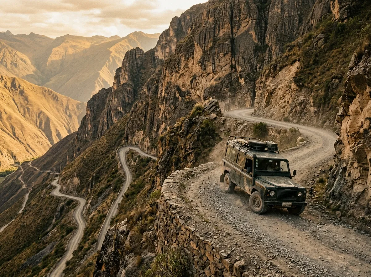
The gradient indicator on the dashboard read 33 percent. This is a number that means very little in the abstract and a great deal when you are sitting in a vehicle pointed upward at an angle that makes the horizon disappear behind the hood. First gear, low range, 2,200 rpm, and the kind of controlled forward motion that feels more like climbing than driving. The switchback ahead was visible for exactly one second before the road turned into rock face and the next section revealed itself — steeper, narrower, and with a view to the left that dropped approximately 400 metres to the valley floor with nothing between the road edge and the void except the optimism of whoever decided a guardrail was unnecessary.
Sani Pass is the road that connects KwaZulu-Natal, South Africa, to the mountain kingdom of Lesotho. It runs 33 km from the Sani Pass border post at 1,540 metres to the summit of the Drakensberg escarpment at 2,874 metres — a vertical gain of 1,334 metres, most of which occurs in a single continuous ascent of about 8 km near the top. The pass is gravel throughout. It is steep, narrow, exposed, and occasionally icy. It is also one of the most spectacular mountain drives on the African continent, which is why we drove up it on a Tuesday morning in June with our passport on the dashboard and our transmission making sounds that suggested it had opinions about the gradient.
Route overview
The pass divides into three distinct sections, each with its own character.
| Section | Distance | Elevation | Gradient | Surface |
|---|---|---|---|---|
| Border post to Good Hope trading post | ~12 km | 1,540m – 1,800m | Gentle (5-10%) | Graded gravel |
| Good Hope to the switchbacks | ~13 km | 1,800m – 2,200m | Moderate (10-20%) | Rough gravel, rocks |
| The switchbacks to summit | ~8 km | 2,200m – 2,874m | Steep (20-33%) | Rock, loose gravel, exposed bedrock |
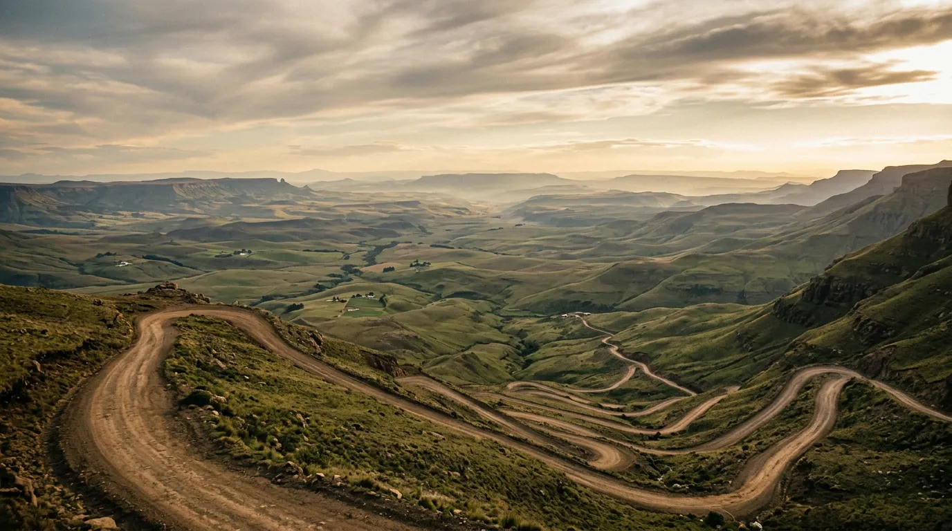
The first 12 km lull you into a false sense of normality. The road is wide enough for two vehicles. The gradient is gentle. The surface is graded gravel. The Mkhomazana River runs alongside, the mountains rise ahead, and the driving is pleasant in a “scenic gravel road” way that gives no warning of what is coming. The Good Hope trading post — a small shop selling drinks and basic supplies — marks the transition. Beyond Good Hope, the road narrows, the gradient increases, and the next 21 km become progressively more demanding until the final switchbacks redefine your understanding of what a road can be.
The lower road: border post to Good Hope
The South African border
The Sani Pass border post sits at the foot of the mountains, about 12 km from the town of Underberg. It opens at 06:00 and closes at 16:00 (South African side) — these hours are enforced, and if you arrive after closing, you wait until morning. The border officials will check three things: your passport, your driver’s license, and your vehicle. The vehicle check is not a formality. They are looking for 4x4 capability — specifically, low-range transfer case. If your vehicle does not have it, you are turned away. We watched this happen to two vehicles during our visit: a Volkswagen Tiguan and a Toyota RAV4. Both AWD, neither with low-range. Both turned around.
The logic is sound. The upper section of the pass has a gradient of 33 percent on loose rock. A vehicle without low-range cannot maintain the controlled speed needed for safe ascent or descent. The border officials know this because they have dealt with the consequences of vehicles that tried.
The valley approach
The first 12 km follow the river valley upstream. The road is wide, the surface is reasonable, and the scenery sets the tone — the Drakensberg escarpment rises ahead, a wall of basalt cliffs and grass-covered slopes that stretches the full width of the horizon. On clear mornings, the escarpment edge is visible as a sharp line against the sky, 1,300 metres above your current position. On cloudy mornings — which are frequent — the cliffs disappear into mist at about the halfway mark, and you drive toward a wall that has no visible top.
The valley is green, even in winter. KwaZulu-Natal receives rain year-round (though more in summer), and the river valley supports thick grass and scattered trees. Baboons are common on this section. They sit on the road and watch vehicles approach with an expression that communicates ownership.
The middle road: Good Hope to the switchbacks
Beyond Good Hope, the road begins to climb in earnest. The gradient increases to 10-15 percent, the surface deteriorates from graded gravel to rough stone, and the valley below starts to recede in a way that makes the mirrors worth checking for the view rather than for traffic. The road narrows to barely more than one vehicle width. Passing places exist — flattened areas where the rock was cut away during construction — but they require one vehicle to reverse, sometimes for 50 metres or more, until a wide spot appears.
Right of way convention on Sani Pass: ascending traffic has priority over descending traffic. The reason is practical — it is easier and safer to reverse downhill than uphill. Flash your headlights to signal your position on blind corners. Listen for engines above you. And accept that if you meet a vehicle on a narrow section, someone is going to spend the next five minutes reversing carefully along an exposed mountain road, and it might be you.
The geology changes as you climb. The lower valley is sandstone — layered, horizontal, warm-coloured. Above about 2,000 metres, the rock shifts to basalt — darker, harder, volcanic. The contact zone between the two is visible in the road cuttings as a distinct line where the geology changes character. This is the Karoo Supergroup, laid down when this part of Africa was a shallow sea, capped by the basalt flows that formed when Gondwana began to split. You are driving through 180 million years of geological history. The rocks do not care about your transmission.
The temperature drop
Altitude changes temperature at approximately 6.5 degrees Celsius per 1,000 metres. Between the border post at 1,540m and the summit at 2,874m, you lose about 8-9 degrees. We started our ascent in June at 14 degrees Celsius. The summit was 5 degrees. With wind chill, it felt like zero. Bring warm layers, even if the weather at the bottom feels mild.
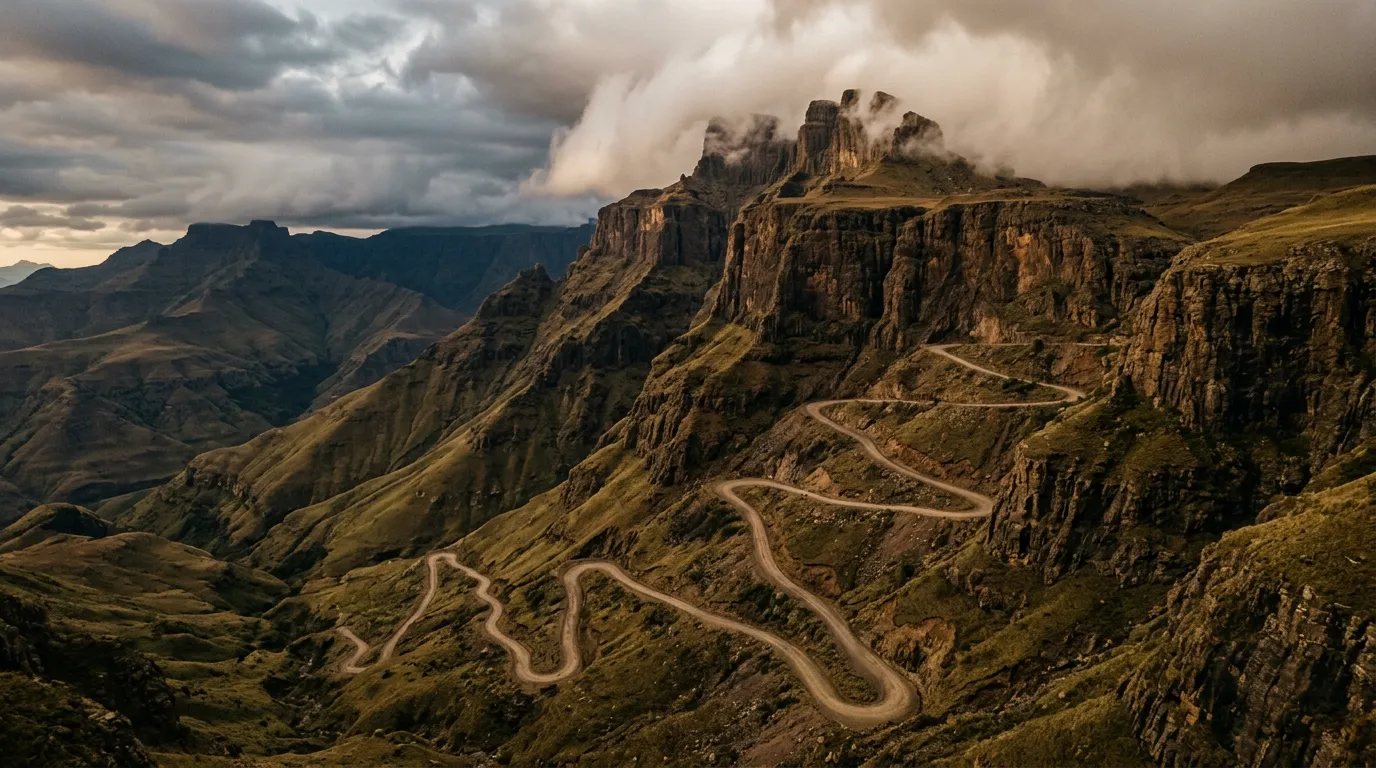
The switchbacks: the upper 8 km
This is the section that defines the pass. At approximately 2,200 metres, the road turns upward and does not relent until the summit. The gradient averages 25 percent and peaks at 33 percent. The surface is exposed rock, loose gravel, and sections of bedrock that have been worn into grooves by decades of tire traffic. The switchbacks — tight, 180-degree turns on the face of the escarpment — are what make this section famous and what make it intimidating.
Driving technique
Low range, first gear, 2,000-2,500 rpm. That is the recipe. The vehicle should be moving at 8-12 km/h — fast enough to maintain momentum, slow enough to keep control. Do not use the brakes on the ascent unless absolutely necessary. If you need to slow down, use engine braking by easing off the accelerator. Braking mid-gradient on loose rock can cause the rear wheels to lose traction and slide.
On the switchbacks themselves:
- Approach wide. The turns are tight enough that you need the full width of the road to make them without reversing.
- Maintain momentum through the turn. Losing speed at the apex of a switchback, on a 30 percent grade, on loose rock, is how vehicles get stuck.
- Look up, not down. The drop to the left is spectacular and terrifying. It is also not relevant to the task of driving. Focus on the road surface, the turn radius, and your engine note.
The ice factor
Between June and August, ice forms on the upper switchbacks. It is not always visible — black ice on dark basalt looks like wet rock — and it transforms a difficult drive into a dangerous one. If you see ice, or if the temperature is below 2 degrees, fit chains to all four wheels. We did not encounter ice on our ascent (it was a clear June morning), but we spoke to the border official who described a July morning when three vehicles were immobilized on the upper switchbacks, unable to move up or down, until the afternoon sun melted the ice. Chains weigh 5 kg per set and take ten minutes to fit. The cost-benefit calculation is obvious.
The summit: Lesotho
The road crests the escarpment at 2,874 metres and the landscape changes completely. The steep, forested slopes of KwaZulu-Natal give way to the high plateau of Lesotho — treeless, wind-scoured grassland stretching to the horizon. The Kingdom of Lesotho is the only country in the world where every point of land is above 1,400 metres, and from the summit of Sani Pass, the plateau feels like the roof of Africa — open, exposed, and profoundly empty.
The Lesotho border post
The Lesotho border post is at the summit. It is a small building, staffed by officials who process passports with the unhurried efficiency of people who have nowhere to rush to. You will need your passport. If you do not have it, you cannot cross into Lesotho, and you will have driven up 1,300 metres of switchbacks for a view and a U-turn. We met a couple who had done exactly this. They were not happy.
Sani Top Chalet
About 500 metres past the border post is the Sani Top Chalet, which claims to be the highest pub in Africa. The elevation is 2,874 metres, and the claim appears to be legitimate — we are not aware of a higher licensed establishment on the continent, though we did not conduct an exhaustive survey. What we can confirm is that a beer at 2,874 metres, after 33 km of mountain pass driving, tastes exactly as good as you would expect it to. The chalet also serves basic meals (burgers, toasted sandwiches, soup) and offers overnight accommodation in rondavels — traditional round stone huts with thatched roofs. If you stay overnight, the sunset over the Drakensberg escarpment edge is something you will remember.
Cost: beer approximately 35 ZAR (2 USD). Rondavel accommodation approximately 800 ZAR per person (45 USD) including dinner and breakfast.
The descent
Descending Sani Pass is, by most accounts, harder than ascending it. The gradient works against you in a different way — instead of needing momentum, you need restraint. Low range, second gear, engine braking. Do not ride the brakes. The standard braking protocol is:
- Use engine braking as primary speed control (low range, second gear).
- Apply brakes briefly to scrub speed before switchbacks.
- Release brakes through the turn — braking while turning on loose rock is how vehicles slide off mountain roads.
- Resume engine braking on the straight sections.
The descent takes approximately 90 minutes from summit to border post. In low range, at controlled speed, it is manageable but tiring. The concentration required for 8 km of continuous steep descent with blind corners and no guardrails is greater than most drivers expect.
Practical logistics
Timing
Start the ascent early. The pass is at its best before 10:00 — clear skies, good visibility, minimal traffic. By early afternoon, clouds form along the escarpment edge and can reduce visibility to 20-30 metres on the upper switchbacks. We ascended at 07:30, reached the summit at 09:45, had a beer, and descended by 13:00. This is a comfortable schedule.
Fuel
The pass is only 33 km. A full tank from Underberg is more than sufficient for the return trip. The nearest fuel to the summit is Mokhotlong, about 80 km into Lesotho on a gravel road — not a convenient refueling stop.
| Location | Distance from pass start | Fuel available |
|---|---|---|
| Underberg | 12 km (south, on tar) | Yes — full service |
| Himeville | 15 km (south, on tar) | Yes — limited hours |
| Mokhotlong (Lesotho) | 80 km (north, gravel) | Yes — variable supply |
| Sani Top Chalet | 33 km (summit) | No |
What to bring
| Item | Notes |
|---|---|
| Passport | Non-negotiable for crossing into Lesotho |
| Warm layers | 8-9 degree temperature drop from base to summit |
| Tire chains | Required June – August for ice on upper switchbacks |
| Camera | You will regret not having one |
| Water (1L per person) | Day trip — basic supplies only |
| Cash (ZAR and Lesotho Loti) | Sani Top Chalet accepts ZAR. Both currencies at parity. |
The numbers
For those who appreciate driving statistics:
| Metric | Value |
|---|---|
| Total distance | 33 km (one way) |
| Elevation gain | 1,334 m |
| Maximum gradient | 33% |
| Average gradient (switchbacks) | 25% |
| Switchbacks | 9 major turns |
| Road width (upper section) | 3.0 – 3.5 m |
| Ascent time | 2 – 2.5 hours |
| Descent time | 1.5 – 2 hours |
| Lowest temperature recorded (summit, winter) | -20°C |
Getting there
From Durban: 330 km via the N3 to Underberg, then 12 km to the border post. About 4 hours.
From Pietermaritzburg: 230 km via the N3 and R617. About 3 hours.
From Johannesburg: 530 km via the N3. About 6 hours. Consider staying overnight in Underberg or Himeville.
Sani Pass combines well with the Baviaanskloof for a multi-week South African off-road trip — the two are about 800 km apart via the N2 coastal road. For mountain pass driving in a different climate, the Richtersveld offers desert passes with a fraction of the altitude but similar isolation. And if the Drakensberg escarpment has given you a taste for extreme altitude, the Simien Mountains circuit in Ethiopia takes the concept to African extremes.
The honest summary
Sani Pass is short. Thirty-three kilometres, which in most driving contexts is barely worth mentioning. But those 33 km contain more sustained intensity than routes ten times their length. The gradient is relentless. The exposure is constant. The switchbacks demand full attention, every time, and the consequence of a mistake is unambiguous — the escarpment edge does not have second chances.
We drove up and we drove down and we drank a beer at the top, and by the time we were back in Underberg on tarred road in second gear without low range, we were tired in a way that had nothing to do with distance and everything to do with concentration. Sani Pass is 33 km that feel earned.
Bring your passport. Check your low-range. Start early.