Ruaha River Crossings
On the second day in Ruaha we did not see another vehicle. Not one. We drove 45 km of park tracks along the Great Ruaha River, crossed two seasonal river beds, photographed four different elephant herds, watched a pack of African wild dogs disassemble an impala in a burst of coordinated violence that lasted approximately ninety seconds, and returned to our campsite as the sun dropped behind the baobab trees — and in the entire day, the only engine we heard was our own.
This is Ruaha’s defining characteristic. It is Tanzania’s largest national park — 20,226 square kilometres, roughly the size of Slovenia — and it receives a fraction of the visitor traffic that the Serengeti and Ngorongoro attract. The reasons are straightforward: it is far from the northern tourist circuit, the infrastructure is minimal, and the driving is genuinely demanding. These are the same reasons it is extraordinary.
Ruaha sits in central Tanzania, approximately 130 km west of Iringa on a road that transitions from paved to gravel to optimistic at a rate that correlates inversely with your distance from town. The park is dominated by the Great Ruaha River — a seasonal waterway that runs full during the rains (January to April) and reduces to a chain of isolated pools connected by dry sand channels during the dry season. The wildlife concentrates around these remaining water sources, which means the dry season offers both the best driving conditions and the most intense game viewing. The river crossings — where the track drops into the sandy riverbed and climbs out the other side — are the route’s signature feature and its primary challenge.
We drove approximately 100 km of Ruaha’s tracks over three days in late September, focusing on the river crossings and the Jongomero area in the park’s south. This guide covers what we found, what tried to kill us, and why we would return.
Route overview
Ruaha’s track network centres on the Great Ruaha River and its tributaries, with most game-drive tracks running parallel to or crossing the river system. The park headquarters at Msembe (7.7500° S, 34.9167° E) serves as the base, with tracks extending north, south, and west along the river.
| Section | Distance | Terrain | Key features |
|---|---|---|---|
| Msembe to Mwagusi crossing | ~25 km | Sand tracks, riverbank roads | Mwagusi Sand River crossing, elephant and hippo |
| Mwagusi to Jongomero area | ~35 km | Sand tracks, rock outcrops, crossings | Remote southern sector, wild dogs, baobab forests |
| Jongomero circuit (loop) | ~20 km | River crossings, sand, hard-packed track | Multiple crossing points, dense wildlife |
| Return to Msembe via ridge track | ~20 km | Rocky ridge, hard-packed gravel | Elevated views over the river valley |
The tracks are marked on park maps (available at Msembe headquarters, usually) and visible on OsmAnd and Maps.me, though the accuracy of GPS track data in Ruaha is lower than in the Serengeti. Several tracks we found on the ground did not appear on any digital map, and one track shown on OsmAnd no longer existed — the river had rerouted it during the last flood season. Cross-reference GPS data with the track visible under your wheels.
Getting to Ruaha
The approach from Iringa
Ruaha’s main entrance (Tungamalenga Gate) is approximately 130 km from Iringa. The first 100 km is a graded gravel road — the A7/B127 — that passes through small villages and agricultural land. The final 30 km is a park access road that degrades progressively and includes a few sections that flood during the rains.
The approach road takes 3-4 hours from Iringa. Do not underestimate this. The gravel surface is corrugated, the villages have speed bumps (and children and livestock), and the final park section requires attention. We left Iringa at 7 AM and reached Msembe at 11 AM, having stopped once for fuel in Tungamalenga village (the last opportunity — fill up here, completely, regardless of gauge reading).
Iringa itself is a mid-sized town with fuel stations, a reasonable supermarket (Shoppers), a hardware store for last-minute equipment, and mobile network coverage. It is the last place where anything logistical is easy. Buy water here (we loaded 50 litres), stock food for three days, and fill every available fuel container. The round trip from Iringa to the park’s southern tracks and back exceeds 400 km. Your vehicle needs to carry all the fuel for this journey.
Park entry
Entry fee: $30 per person per day (significantly less than the Serengeti or Ngorongoro). Vehicle fee: $40 per day. Camping fee: $30 per person per night. These fees are payable by Tanapa card at the gate. The relative affordability compared to the northern parks is one of Ruaha’s underappreciated advantages.
Day 1: Msembe to Mwagusi crossing
Msembe headquarters
Msembe is Ruaha’s administrative hub. It consists of the park headquarters building, a small shop (warm soft drinks, biscuits, basic supplies — do not rely on this for provisions), a public campsite, and several bandas (basic cabins). The campsite is unfenced — standard for Tanzanian parks — and sits on a bluff overlooking the Great Ruaha River. The view from the campsite is the best free accommodation view we have encountered in any national park, anywhere. Hippos in the river below. Elephants on the far bank. The sound of the river — or, in late dry season, the sound of wind across the sand channel that the river has become.
The Mwagusi Sand River
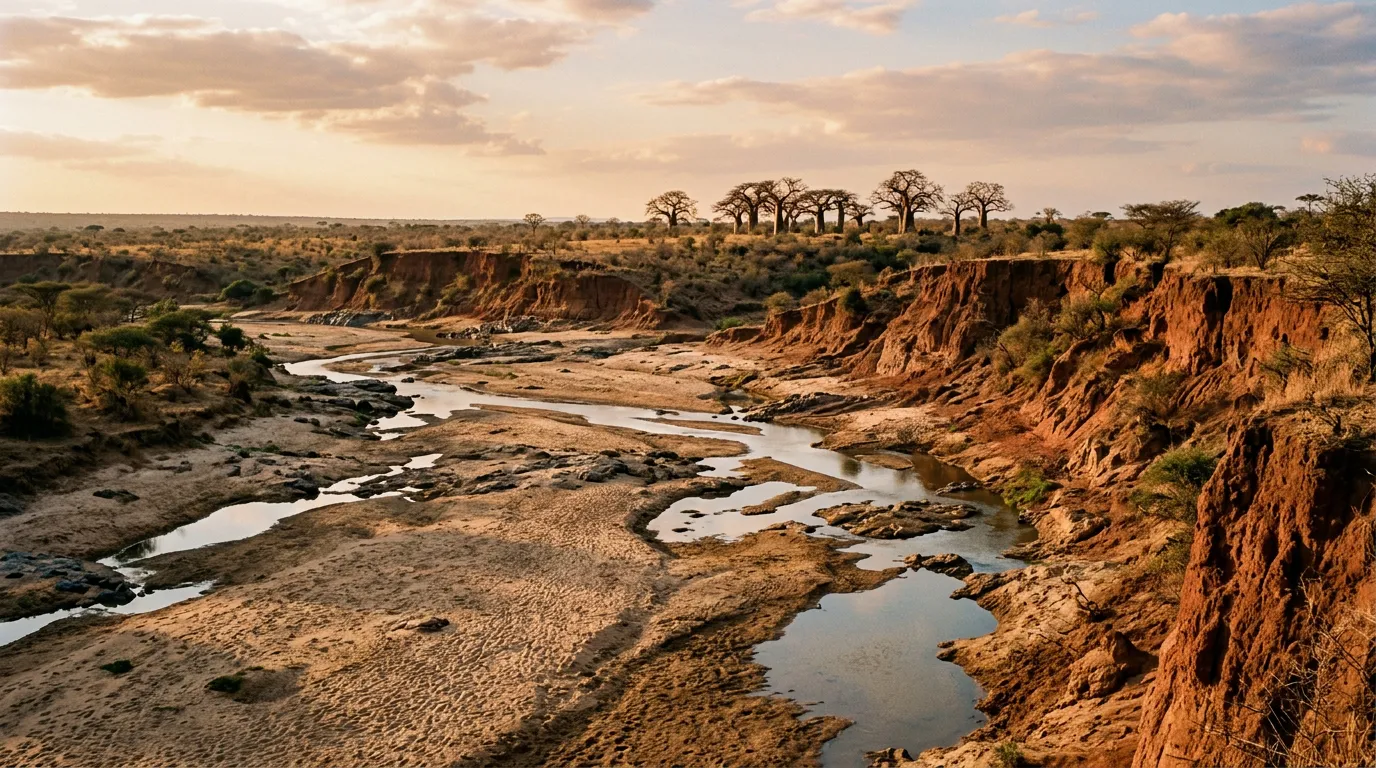
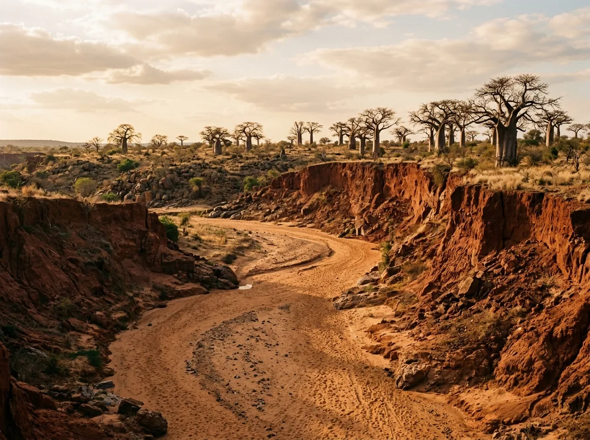
The Mwagusi is a tributary of the Great Ruaha, and during the dry season it is a sand river — a broad channel of fine sand between steep red-earth banks, with occasional pools of standing water where the subsurface flow meets an impermeable rock layer. The track crosses the Mwagusi at a point approximately 25 km south of Msembe.
The crossing is the first serious test. The sand is fine-grained, soft in places, and the channel is approximately 80 metres wide. In late dry season the water is absent, but the sand depth varies — firm on the established track, potentially deep and soft if you deviate.
Sand crossing protocol for Ruaha riverbeds:
- Stop at the bank edge. Walk the crossing on foot. Test firmness with your boot — if your foot sinks past the ankle, the vehicle will struggle.
- Identify the existing track. Tire marks from previous vehicles indicate the firmest line.
- Deflate tires to 18-20 PSI. The increase in contact area is essential.
- Engage low-range, second gear. Maintain steady momentum — 15-20 km/h.
- Do not stop in the riverbed. If you lose momentum, you will sink.
- On the far bank, stop and assess. Re-inflate tires if the next section is hard-packed.
We crossed the Mwagusi in approximately two minutes of actual driving. The sand was firm on the established track. The vehicle fishtailed slightly in a softer section mid-channel but maintained momentum. The experience was tense in the way that sand driving is always tense — the constant question of whether the next metre of sand will support the vehicle or not. It did. This time.
Wildlife along the Mwagusi
The dry riverbed is a wildlife highway. The remaining pools attract hippos (we counted twelve in one pool, stacked together like oversized bath toys in a space barely large enough for five), crocodiles basking on the sand banks, and a steady procession of animals coming to drink: elephants, giraffes, impala, greater kudu. The kudu are notable — Ruaha is one of the few parks where you reliably see Greater kudu, and the males with their spiral horns standing on a red sand bank with baobab trees behind them look like they were arranged by a photographer with an unlimited budget.
Day 2: Jongomero area and the southern crossings
The drive south
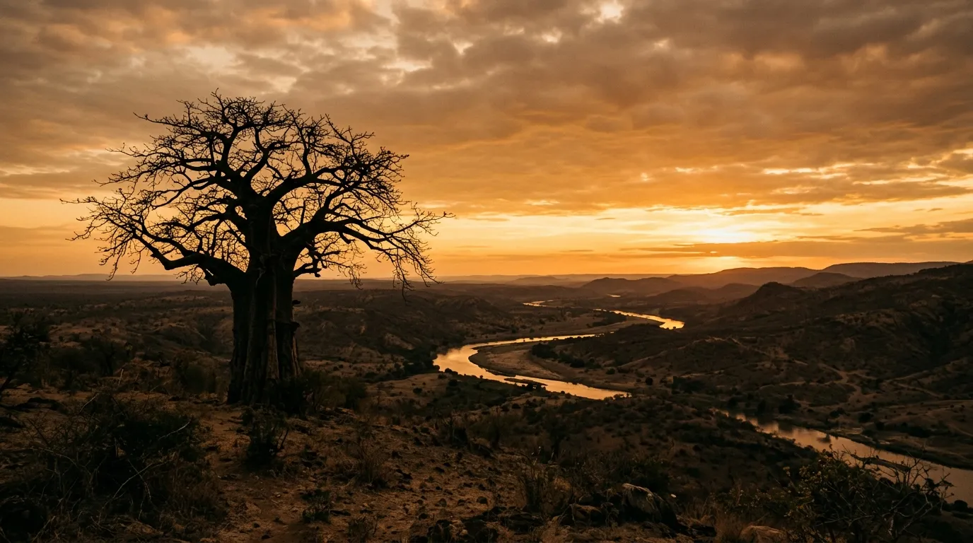
South of the Mwagusi crossing, the landscape changes. The riverine woodland gives way to drier, more open terrain dominated by baobab trees — massive, bulbous trunks that look less like trees and more like something planted upside-down by a creation myth. The baobabs here are old. Some of them are estimated at over 1,000 years. They serve as landmarks in a landscape where the terrain is otherwise flat and repetitive, and we found ourselves navigating between them as reference points: “turn left at the baobab with the elephant damage,” “straight on past the baobab with the bee colony.”
The tracks in the southern section are less traveled than those near Msembe. The surface alternates between hard-packed gravel (fast, comfortable) and soft sand channels (slow, careful). The GPS showed tracks that were occasionally present on the ground and occasionally suggestions. We followed tire marks where available and trusted the general direction where they were not.
The river crossings
The Jongomero area includes multiple crossings of the Great Ruaha River and its tributaries. Each crossing is different, and each must be assessed independently.
| Crossing | Width | Typical dry-season depth | Bottom surface | Notes |
|---|---|---|---|---|
| Mwagusi (main) | ~80m | Dry sand | Firm sand, some soft patches | Established track visible |
| Ruaha crossing north | ~120m | 20-40 cm standing water | Sand and gravel | Walk it first. Hippos may be present. |
| Ruaha crossing south | ~100m | Dry to ankle-deep | Mixed sand, some rock | Firm in centre, soft at edges |
| Jongomero tributary | ~40m | Dry sand | Soft sand | Short but very soft. Momentum critical. |
The key principle for all Ruaha crossings: the riverbed shifts. What was a firm crossing in September may be a soft sand trap in October after a flash rain upstream rearranges the channel. There is no substitute for walking the crossing on foot before driving it. This takes ten minutes and may save you ten hours of recovery.
The hippo issue is real. The river pools between the crossings contain hippos, and hippos are statistically Africa’s most dangerous large animal. Do not wade into a pool to check depth. Throw rocks upstream to check for hippo presence (they surface and snort when disturbed). If hippos are visible in or near a crossing, wait, or find another crossing point.
Wild dogs at Jongomero
Ruaha has one of Tanzania’s largest populations of African wild dogs — an endangered predator that hunts in coordinated packs with a kill rate above 80 percent (compared to approximately 25 percent for lions). We found a pack of 14 dogs near Jongomero, resting in the shade during midday and then launching into a hunt in the late afternoon that covered 3 km of open ground at a speed that was difficult to follow even in the vehicle.
The dogs hunt by running their prey to exhaustion. The pack splits, with some dogs driving the prey and others cutting off escape routes. The actual kill, when it comes, is fast and efficient — the dogs pull the prey apart from multiple directions. It is not comfortable to watch. It is one of the most impressive displays of cooperative behavior in the animal kingdom.
We followed the hunt at a respectful distance (100+ metres) in the vehicle. The dogs are not concerned by vehicles at this range, and the pursuit crossed open ground that was easy to drive. Not every Ruaha visit will produce a wild dog sighting — they range widely and are not territorial in the same way as lions — but the park is one of the best places in East Africa to encounter them.
Day 3: Ridge track and return
The elevated route
The return to Msembe via the ridge track offers a different perspective. The track climbs from the river valley onto a low ridge running parallel to the Great Ruaha, passing through mixed woodland and rocky outcrops before descending back to the river near Msembe. The surface is hard-packed gravel and rock — after two days of sand, the firm ground felt luxurious.
The ridge provides views over the river valley that put the landscape into context: the sinuous line of the river (or its dry bed) marked by dark green riverine forest, the open savanna stretching to the escarpment in the west, and the isolated baobab silhouettes punctuating the middle distance. In the early morning light, with mist still clinging to the river course, the view has a quality that makes you stop the vehicle and sit for a while.
Rock formations and klipspringer
The rocky outcrops on the ridge are worth pausing for. The rock is granite and gneiss — basement rocks that predate the surrounding sediments by billions of years — and the formations create miniature habitats for klipspringer (a small antelope that lives exclusively on rocky terrain), rock hyrax, and an impressive variety of raptors. We saw Verreaux’s eagles on two separate kopjes, identifiable by their black and white plumage and their habit of sitting on the highest available rock looking territorial.
Camp and logistics
Msembe Public Campsite
The campsite at Msembe is basic and magnificent. Flat ground on a bluff above the river. Long-drop toilets. A water tap (drinkable, tested). No electricity. No fencing.
The campsite costs $30 per person per night. Bring everything you need for cooking, sleeping, and sanitation. A roof tent on the vehicle is the standard self-drive safari sleeping arrangement and elevates you above the ground-level visitors (hyenas, genets, the occasional honey badger).
Nights at Msembe are not quiet. The hippos grunt and splash in the river below. Lions call from across the valley — a sound that travels kilometres in the still night air and produces a physiological response that no amount of rational knowledge about their disinterest in tents can fully suppress. Hyenas visit the campsite. Elephants sometimes pass through. A German couple at the campsite during our visit had an elephant walk between their vehicle and their tent during the night — close enough to touch, though they wisely did not.
Alternative camps and lodges
The Jongomero area has one luxury camp (Jongomero Camp, approximately $800 per person per night) and several designated bush camping areas that are flat ground with nothing else. The bush camping areas require self-sufficiency: no water, no toilets, no other humans.
For bush camping: carry a portable toilet, a shovel, and bags for waste. Bury human waste at least 30 cm deep and 200 metres from water sources. Burn toilet paper. Pack out all other waste.
Equipment and spares
| Item | Required | Notes |
|---|---|---|
| Satellite phone/communicator | Yes | No coverage. No exceptions. Garmin inReach minimum. |
| 40L extra fuel | Yes | The Iringa round trip is 400+ km. Our consumption was 22L/100km. |
| 50L extra water | Yes | 5L/person/day plus vehicle cooling reserve |
| Recovery boards (pair) | Yes | Used once on the Jongomero tributary crossing |
| Tow strap | Yes | No other vehicles to help, but a tree works too |
| Full camping equipment | Yes | Roof tent, cooking gear, cooler with ice (ice from Iringa) |
| Folding shovel | Yes | For digging out and campsite sanitation |
| Tire compressor | Yes | Pressure changes for sand crossings |
| 2 spare tires | Recommended | Thorns are less common than in Serengeti but still present |
| Comprehensive first aid kit | Yes | Nearest medical facility: Iringa, 3-4 hours away |
Fuel and water
Our fuel consumption over three days and approximately 360 km (including the approach from Iringa) was 79 litres. The Land Cruiser’s 90-litre main tank plus 20 litres in jerry cans gave us a total range of approximately 500 km — enough, but without generous margin. A vehicle with a 60-litre tank would need 40-50 litres in jerry cans.
Water: we used approximately 35 litres over three days for two people (drinking, cooking, minimal washing). The campsite tap at Msembe provided a refill opportunity, but relying on it as a primary source is unwise — pumps fail, pipes break, and in a park where the nearest plumber is a four-hour drive away, “currently working” is an optimistic assessment of any infrastructure.
Season and timing
Ruaha’s dry season runs from July to November. The park is accessible year-round, but the wet season (January to April) makes many tracks impassable and the river crossings dangerous. The sweet spot for wildlife viewing is September to November: the rivers have dried to their minimum, animals are concentrated around the remaining pools, and the vegetation is thin enough for visibility.
| Month | Conditions | Wildlife | Recommendation |
|---|---|---|---|
| January – April | Wet season, tracks flooded | Dispersed, difficult viewing | Not recommended for self-drive |
| May – June | Drying, tracks improving | Animals beginning to concentrate | Possible, check conditions |
| July – August | Dry, good tracks | Good concentrations around water | Good driving season |
| September – November | Peak dry, best tracks | Maximum concentration, peak viewing | Best time. Go now. |
| December | Variable, early rains possible | Animals beginning to disperse | Check forecasts |
Getting there from other Tanzania routes
From the Serengeti or Ngorongoro: the transfer to Ruaha requires a full day of highway driving. The route runs south from the northern parks via Dodoma or Iringa on tarmac roads — approximately 700-800 km depending on the route chosen. This is not exciting driving, but it connects Tanzania’s two great wildlife driving regions.
The Serengeti Western Corridor and Ngorongoro Rim Tracks combine naturally with each other (same region, shared road access). Adding Ruaha turns a one-week northern circuit into a two-week cross-country expedition. This is the approach we recommend for anyone committed to experiencing what Tanzania offers the self-drive adventurer.
The honest summary
Ruaha is the hardest of our Tanzania routes to reach and the most rewarding to drive. The remoteness is genuine — no other vehicles, no mobile coverage, no services, no safety net beyond what you carry in the vehicle. The river crossings require skill and judgment. The logistics require planning that begins in Iringa and does not tolerate gaps.
In return, you get one of Africa’s great national parks almost entirely to yourself. The wildlife is dense, varied, and unbothered by human presence — the elephants regard you with curiosity rather than alarm, the wild dogs hunt without acknowledging your vehicle, and the hippos in the river pools have not yet developed the cynicism of their Serengeti relatives toward diesel engines and camera lenses.
We have driven safari routes in five African countries. Ruaha is the one where we felt most strongly that we were driving through a landscape that was functioning as intended — not managed, not curated, not packaged for consumption, but simply existing, and allowing us to pass through it.
Carry fuel. Carry water. Walk every crossing.