King’s Highway Off-Road Detours
The King’s Highway is one of the oldest continuously used roads in the world. The biblical Book of Numbers mentions it. The Nabataeans traded along it. The Romans paved it. The Crusaders built castles to control it. The Jordanian government tarmacked it and now trucks use it to move goods between Amman and Aqaba, which is significantly less romantic but considerably more practical.
The highway itself — Route 35 on modern Jordanian maps — runs 280 km from Madaba in the north to Tafila in the south, passing through the highland plateau east of the Dead Sea. It is paved, busy, and perfectly driveable in any vehicle. It is also, frankly, not why we came to Jordan. We came for the side tracks. The wadis that cut east and west from the highway. The unpaved access roads to Crusader castles. The seasonal tracks to hot springs and viewpoints that the tour buses cannot reach. These detours, taken together, cover approximately 260 km of additional driving across terrain that ranges from graded gravel to rocky wadi bed, and they transform a straightforward highway drive into something substantially more interesting.
We drove the King’s Highway from north to south over two days, taking every detour that our vehicle and schedule allowed. This guide documents the seven we consider most worthwhile.
Route overview
The detours are presented in north-to-south order, which is how we drove them. You can reverse the direction without difficulty, or cherry-pick individual detours as side trips.
| Detour | Distance (round trip from highway) | Vehicle needed | Time needed | Difficulty |
|---|---|---|---|---|
| Wadi Mujib viewpoint track | 18 km | High-clearance 2WD | 1.5 hours | Easy |
| Wadi Mujib northern approach | 24 km | 4x4 | 2.5 hours | Moderate |
| Kerak Castle back road | 14 km | High-clearance 2WD | 1 hour | Easy |
| Wadi Hasa hot springs | 22 km | 4x4 | 2 hours | Moderate |
| Khirbet et-Tannur access | 8 km | High-clearance 2WD | 45 min | Easy |
| Sela fortress track | 12 km | 4x4 | 1.5 hours | Moderate |
| Dana village approach (off-road) | 16 km | High-clearance 2WD | 1 hour | Easy |
Total additional distance: approximately 114 km of detour driving. Combined with the 260 km of highway driving between Madaba and Tafila, the full route covers about 375 km. We spread this over two days, spending the first night in Kerak.
Day 1: Madaba to Kerak
Starting point: Madaba (31.9022° N, 35.7982° E)
Madaba is a small city 30 km south of Amman, known for its Byzantine-era mosaic map of the Holy Land in St. George’s Church. It is also the most practical starting point for the King’s Highway drive — it has fuel stations, ATMs, a few decent hotels, and a supermarket where you can stock up on water and snacks. Fill your tank here. The next reliable fuel is Kerak, about 130 km south, and the detours add distance.
Detour 1: Wadi Mujib viewpoint track
| **GPS start: 31.4682° N, 35.7873° E | Distance: 18 km round trip | Vehicle: High-clearance 2WD** |
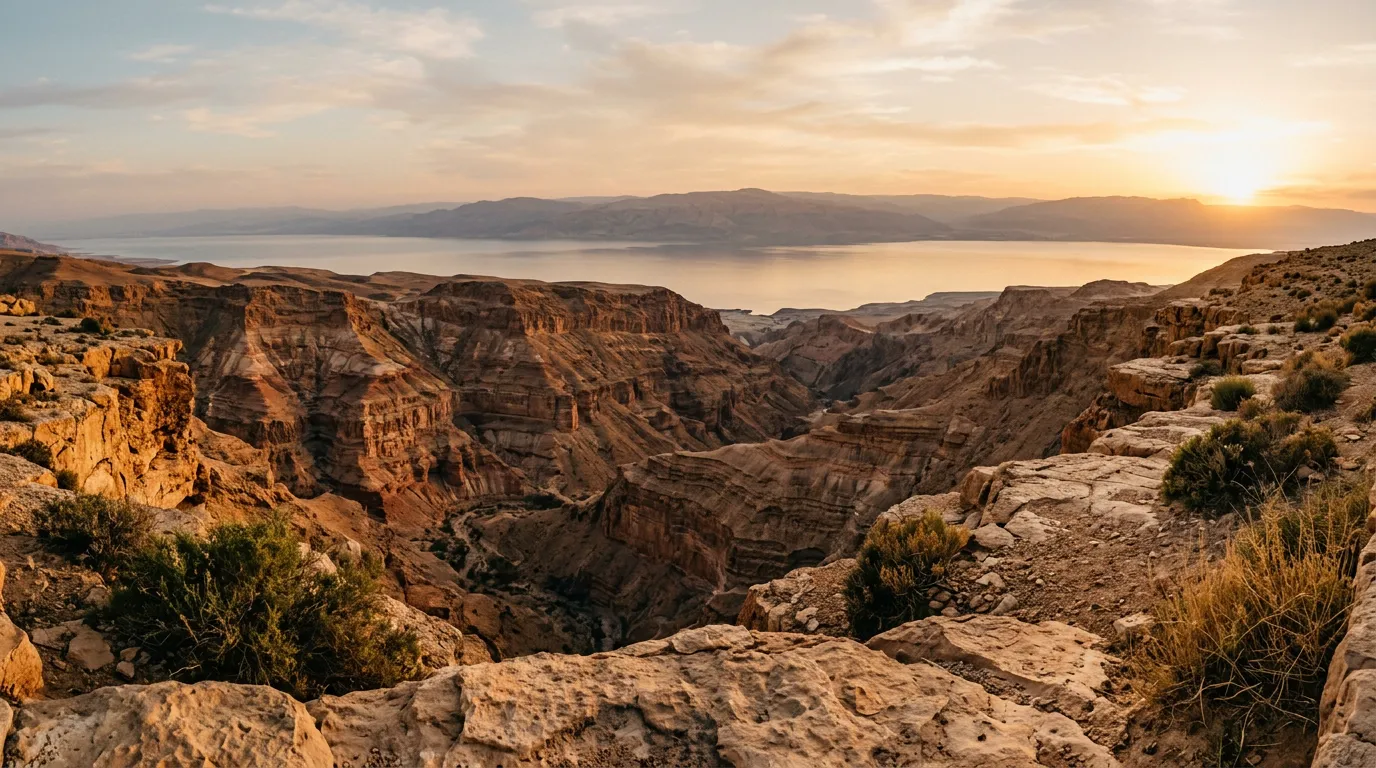
The Wadi Mujib gorge is often called Jordan’s Grand Canyon, and while that comparison oversells the scale (Mujib is about 500m deep compared to the actual Grand Canyon’s 1,600m), it undersells the drama. The canyon is narrow, steep-sided, and deeply incised into the plateau, and the standard viewpoint from the highway bridge gives you only a partial sense of its depth.
The detour follows a gravel track that leaves the highway approximately 3 km south of the Mujib bridge, heading west along the northern rim. The track is maintained by goatherds and is passable in a high-clearance 2WD — some loose rocks, some ruts, but nothing that requires four-wheel drive. After about 9 km, it reaches a flat area at the canyon rim where you can park and walk to the edge.
The view from here is directly down into the wadi — a sheer drop of several hundred metres to the river at the bottom, with the layered canyon walls revealing the same geological sequence that makes the Dana descent so remarkable. Morning light is best, when the western wall is lit and the eastern side is in shadow, creating depth that the midday sun flattens.
Detour 2: Wadi Mujib northern approach
| **GPS start: 31.4915° N, 35.7612° E | Distance: 24 km round trip | Vehicle: 4x4** |
For those with a 4x4 and extra time, a rougher track descends from the plateau toward the upper reaches of the Wadi Mujib reservoir. This is not a through-route — it dead-ends at the reservoir shore — but the descent through the side canyon is scenic and the driving is satisfying. The track is rocky, with several sections of loose basalt that need low-range, and the gradient runs 10-15% in places.
The reservoir itself (part of the Mujib Dam project, completed in 2004) has a strange beauty — turquoise water in a dark basalt canyon, surrounded by absolute silence. On a weekday in November, we had the entire place to ourselves.
Return the way you came. The round trip takes about 2.5 hours, including time at the reservoir.
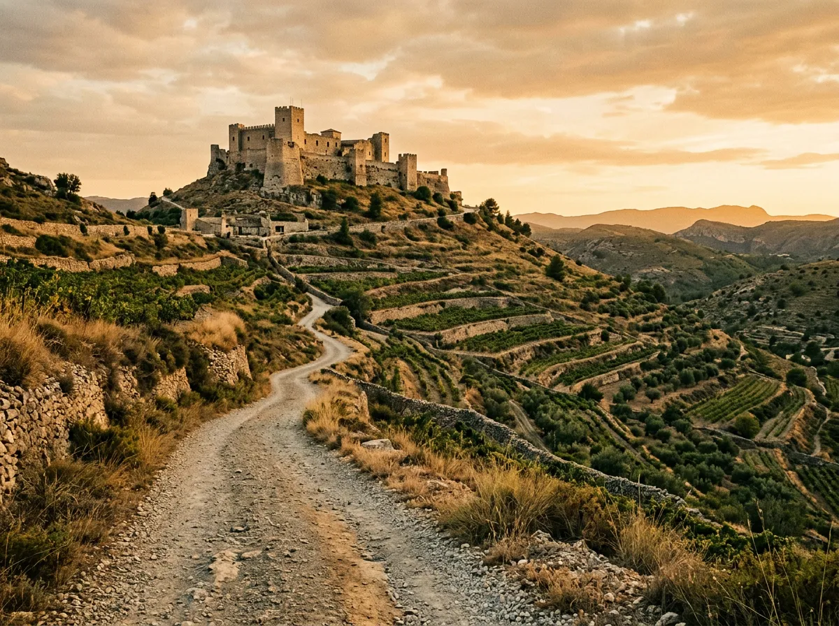
Detour 3: Kerak Castle back road
| **GPS start: 31.1782° N, 35.6951° E | Distance: 14 km round trip | Vehicle: High-clearance 2WD** |
Kerak Castle is one of the largest Crusader fortresses in the Levant, built by Paganus the Butler (a genuinely wonderful name) in 1142. Most visitors approach it on the paved road from the town of Kerak, which involves navigating a small city with narrow streets and ambitious drivers. The back road approaches from the south, following a gravel track that climbs from the highway to the castle ridge via an agricultural valley.
The track is easy — graded gravel, gentle gradient, a few potholes — but the approach is rewarding. You arrive at the castle from the side that the tourists do not use, which means you park in relative peace and enter through the southern gate rather than fighting for a spot in the main car park. The castle is worth the visit regardless of your approach route: the Crusader halls, Mamluk additions, and underground galleries are genuinely impressive, and the view from the ramparts covers the Dead Sea and the hills of Palestine beyond.
Entrance fee: 2 JOD per person.
Kerak: overnight stop
Kerak is the natural halfway point on the King’s Highway. The town has several hotels (the Kerak Rest House, next to the castle, is adequate and conveniently located), a few restaurants, fuel stations, and a small souk. Fuel up here — the next reliable station is Tafila, about 60 km south, and the Day 2 detours will add distance.
Day 2: Kerak to Tafila
Detour 4: Wadi Hasa hot springs
| **GPS start: 30.9042° N, 35.6517° E | Distance: 22 km round trip | Vehicle: 4x4** |
Wadi Hasa is a major east-west wadi that the King’s Highway crosses between Kerak and Tafila. The highway bridge spans the wadi high above, but a track descends to the wadi floor from the northern side, where natural hot springs emerge from the rock along the river. The water temperature varies from pleasantly warm to genuinely hot (50-60 degrees Celsius at the source), and the springs have created a series of natural pools where the hot water mixes with the cooler river water.
The descent track is rough — rocky switchbacks that need four-wheel drive and patience. The wadi floor is flat sand and gravel, and the drive along the river to the springs is pleasant. The springs themselves are unmarked and undeveloped, which is part of their appeal. We soaked for an hour in a pool that was just the right temperature, looking up at the canyon walls, and saw no other people.
The return climb is more demanding than the descent — the loose surface is harder to grip going uphill, and the gradient requires low-range. Allow an hour for the climb.
Detour 5: Khirbet et-Tannur access
| **GPS start: 30.8517° N, 35.6283° E | Distance: 8 km round trip | Vehicle: High-clearance 2WD** |
Khirbet et-Tannur is a Nabataean temple site on a hilltop above the Wadi Hasa. It was a major religious centre in the 1st and 2nd centuries CE and was excavated in the 1930s — most of the finds are in the Jordan Archaeological Museum in Amman. The site itself is sparse (foundation walls, cisterns, column bases), but the location is spectacular: a flat-topped hill with 360-degree views over the Wadi Hasa canyon and the surrounding plateau.
The access track is a short, easy gravel road from the highway. It is worth the detour primarily for the viewpoint, which on a clear day extends to the Dead Sea in the west and the eastern desert in the other direction. We spent about 45 minutes at the site, including the drive.
Detour 6: Sela fortress track
| **GPS start: 30.7283° N, 35.5517° E | Distance: 12 km round trip | Vehicle: 4x4** |
Sela (also spelled as-Sela or Sila) is an Iron Age fortress on a sandstone mesa about 6 km off the King’s Highway, near the town of Tafila. The fortress is carved into the rock — steps, cisterns, and chambers cut directly from the sandstone, in a style that feels like a smaller, less famous version of Petra. The track to the mesa base is rocky and requires four-wheel drive — the last 2 km are a rocky riverbed that is impassable after rain.
From the parking area at the base, it is a short but steep scramble (about 20 minutes) to the fortress. The rock-cut features are well-preserved and the view from the top of the mesa — across the sandstone badlands south toward Dana — is one of the best we found on the entire King’s Highway.
This site receives almost no visitors. We had it entirely to ourselves, which added to the atmosphere of standing in a 2,800-year-old fortress looking out over terrain that cannot have changed much since the Edomites built it.
Detour 7: Dana village approach (off-road)
| **GPS start: 30.6883° N, 35.6117° E | Distance: 16 km round trip | Vehicle: High-clearance 2WD** |
The standard approach to Dana village is a paved road from the King’s Highway that descends through switchbacks to the village. There is also a gravel track that approaches from the south, following a ridge line before dropping to the village. This track is rougher than the paved approach but offers better views — you are driving along the edge of the Wadi Dana canyon with the Rift Valley visible below, and the light in the late afternoon turns the canyon walls copper and gold.
This detour works well as a prelude to the Dana to Feynan Canyon Trail. Arrive in Dana via the gravel approach in the afternoon, spend the night at the RSCN guest house or one of the village homestays, and begin the descent to Feynan the next morning.
Practical information
Fuel planning
The King’s Highway has fuel stations in Madaba, Kerak, and Tafila. Between Madaba and Kerak (130 km + detours), the fuel gap is manageable with a full tank. Between Kerak and Tafila (60 km + detours), the distance is shorter but the terrain is rougher. Fill up in both towns.
| Location | Fuel available | Notes |
|---|---|---|
| Madaba | Yes, multiple stations | Fill up here before starting |
| Dhiban | Yes, one station | Small town, limited hours |
| Kerak | Yes, multiple stations | Fill up for Day 2 |
| Tafila | Yes, multiple stations | End point, or transit to Dana |
Road conditions on the highway
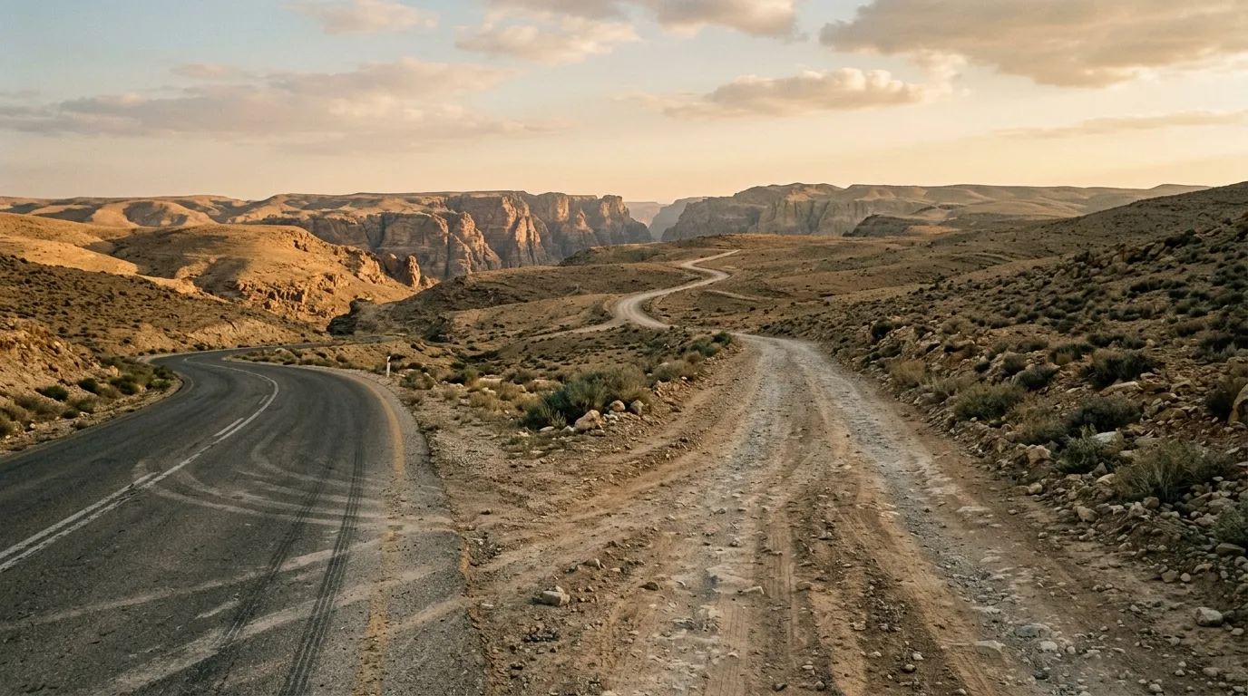
The King’s Highway (Route 35) is paved but narrow — mostly single lane in each direction with occasional overtaking sections. The surface varies from good to potholed, particularly between Dhiban and Kerak. The road carries significant truck traffic, and passing on blind corners is considered normal driving practice by Jordanian truckers, which means you need to be watchful on the narrow sections. The detours, by contrast, are blissfully empty — we encountered more goats than vehicles on most of the side tracks.
Costs
| Item | Cost |
|---|---|
| Kerak Castle entrance | 2 JOD per person |
| Dana Nature Reserve (if continuing to Feynan) | 10 JOD per person |
| Kerak hotel (mid-range) | 30-50 JOD per night |
| Fuel (full tank fill-up) | 25-30 JOD |
Maps and navigation
The King’s Highway itself is well-signed. The detours are not. We used Maps.me (which has most of the tracks marked, though not always accurately) supplemented with GPS coordinates noted in advance. OsmAnd is an alternative with more detail in some areas. A paper Jordanian road map (available at bookshops in Amman) is a useful backup — it shows many of the tracks that digital maps miss.
Seasonal considerations
The King’s Highway and most detours are accessible year-round, with the exception of the wadi sections (Mujib northern approach, Wadi Hasa hot springs) which become impassable after heavy rain. The wet season runs roughly December to March, with the heaviest rainfall typically in January and February. Even in the wet season, rain is intermittent — check the forecast day by day.
Spring (March to May) is the most pleasant season: wildflowers on the plateau, moderate temperatures, green hillsides. Autumn (September to November) is excellent as well. Summer is hot (35-40 degrees on the plateau, hotter in the wadis) but not unmanageable — the King’s Highway runs at 800-1,300 metres elevation, which provides some relief.
Combining routes
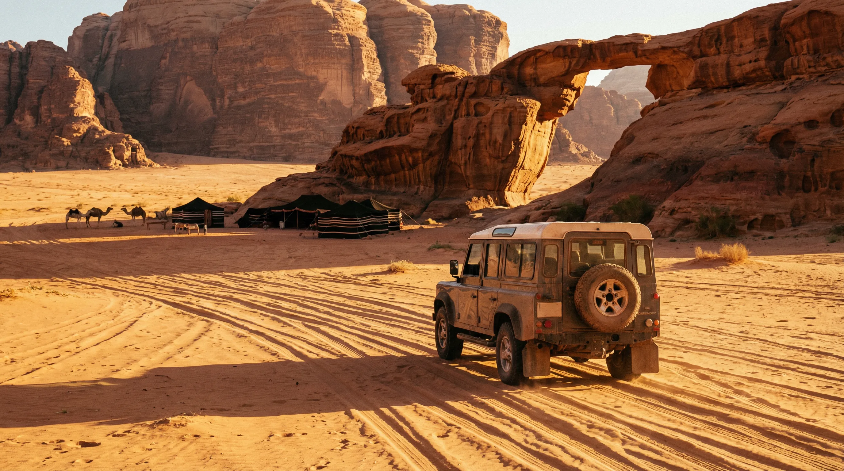
The King’s Highway detours form a natural lead-in to Jordan’s more demanding off-road routes. From Tafila at the southern end, Dana village is 30 km east and the Dana to Feynan trail begins there. From Feynan at the bottom of the Dana descent, the Dead Sea highway runs south to the Wadi Rum turnoff, about 150 km away.
A logical three-to-four day itinerary through Jordan’s off-road highlights: Day 1, King’s Highway detours from Madaba to Kerak. Day 2, Kerak to Dana via remaining detours. Day 3, Dana to Feynan descent. Day 4, highway transit to Wadi Rum, begin the desert tracks. This covers the full spectrum of Jordan’s off-road terrain — plateau gravel, canyon descents, wadi beds, and desert sand — in a compact route.
For comparable detour-based driving in other countries, Morocco’s Dades and Todra Gorges offer a similar concept: a main paved road with spectacular side canyons branching off it.
What makes the detours worth it
The King’s Highway is a famous road, and deservedly so — the history is layered as deeply as the geology. But the highway experience is compromised by traffic, by development, and by the reality that a paved two-lane road full of trucks is not why most of us travel to Jordan. The detours restore what the highway has lost. They are empty, quiet, and slow. The tracks follow the contours of the land rather than cutting through them. The viewpoints are your own. The hot springs have no entrance fee and no changing rooms. The Crusader castle appears from behind a hill of olive trees without a billboard or a souvenir shop to announce it.
This is the King’s Highway as it was before it was a highway — a route through landscape, not past it.