Dana to Feynan Canyon Trail
Standing at the edge of Dana village, you can see the Rift Valley floor nearly 1,700 metres below. The canyon walls drop away in stepped layers of sandstone, limestone, and basalt — each layer a different colour, each colour a different geological era, the whole thing looking less like a landscape and more like a cross-section diagram from a university textbook. Somewhere down there, at the bottom of all those layers, is Feynan. The track that connects these two points covers 58 km and drops through roughly 1,700 vertical metres. It is one of the most geologically dramatic drives in the Middle East, and one of the most demanding. We drove it in a day, which is the standard, and by the end we had a deep and personal respect for anyone who does it twice.
The Dana to Feynan trail descends from the highland plateau of the Dana Nature Reserve to the copper-mining settlement of Feynan in the Wadi Araba, the southern extension of the Jordan Rift Valley. The reserve is managed by the Royal Society for the Conservation of Nature (RSCN), and the trail passes through four distinct biogeographical zones — Mediterranean, Irano-Turanian, Saharo-Arabian, and Sudanian tropical — in the space of about three hours of driving. This is unusual. Most drives take you through one climate zone. This one takes you through four.
Route overview
The trail begins at Dana village (30.6647° N, 35.6271° E), a 15th-century stone settlement perched on the rim of the Wadi Dana canyon. It ends at Feynan (30.6184° N, 35.5123° E), a cluster of archaeological sites and a single eco-lodge on the floor of the Rift Valley. The route is not a simple A-to-B descent — it traverses laterally along the canyon before committing to the switchback section, then follows a wadi bed to the valley floor.
| Section | Distance | Elevation change | Terrain | Time |
|---|---|---|---|---|
| Dana village to canyon rim traverse | ~12 km | 1,500m to 1,300m | Gravel track, rocky surface | 45 min |
| Switchback descent | ~8 km | 1,300m to 400m | Exposed switchbacks, loose rock | 1.5 hours |
| Wadi bed to Feynan | ~25 km | 400m to −200m | Dry wadi, sand, gravel | 2 hours |
| Feynan to Dead Sea highway | ~13 km | −200m to −100m | Gravel track, improving surface | 30 min |
Total driving time: approximately 4.5 to 5.5 hours. This assumes no stops, no getting lost, and no extended periods of staring at the canyon walls in geological wonder. Realistically, add 2-3 hours for all three.
Preparation
Vehicle requirements
This trail requires a 4x4 with low-range transfer case. The switchback descent has sections of 15-20% gradient on loose rock, and you will need engine braking in low first gear to avoid burning your brake pads to nothing by the bottom. A high-clearance 2WD will not make it through the wadi sections — there are rock steps and sand patches that need four-wheel drive and clearance.
We drove a Toyota Land Cruiser Prado with 220mm of ground clearance, which was adequate. A vehicle with less clearance would be problematic in the wadi bed sections, where embedded rocks create steps of 20-30 cm.
Fuel
There is no fuel between Dana village and the Dead Sea highway (Route 65). The total route distance is 58 km, but the fuel consumption is high — we used approximately 15 litres for this distance, which works out to about 26L/100km. Low-range driving at walking pace on steep descents is not fuel-efficient. A full tank is mandatory. If your vehicle has a small tank (under 60L), carry a 5L jerry can.
Dana village itself has no petrol station. The nearest fuel is Tafila, approximately 30 km north on the King’s Highway, or the stations along the Dead Sea highway at the far end.
Water and supplies
Carry a minimum of 5 litres of water per person. The descent takes you from a cool highland climate into the Rift Valley, where temperatures are typically 10-15 degrees warmer. In October, that means arriving at Feynan in 35-degree heat even if you started in Dana at a pleasant 22 degrees.
There is a small shop in Dana village that sells water and basic snacks. There are no supplies of any kind on the trail itself. Feynan Ecolodge provides meals and water to guests, but you need a reservation.
The drive
Dana village: the start point
Dana village is worth arriving early for. The settlement sits at the canyon rim, its Ottoman-era stone buildings clinging to the edge in a way that suggests either remarkable engineering or remarkable optimism. The RSCN operates a guest house here, and the village viewpoint is one of the most photographed spots in Jordan for good reason — the canyon opens below you in a series of descending terraces, each a different shade of red and brown and grey, stretching west toward the Rift Valley floor and, beyond it, the mountains of Israel and Palestine on the far side.
The trail starts at the western edge of the village, signed for Feynan. The first few hundred metres are paved — enjoy them, because it is the last smooth surface you will see for several hours.
Canyon rim traverse (12 km)
The first section follows the canyon rim southward, traversing across the head of several side valleys. The track is gravel over rock — firm, bumpy, and straightforward as long as you stay on it. The drop-offs to your left are significant but not sheer, and the track is wide enough for a single vehicle. Oncoming traffic is rare — we saw one vehicle in this section, a Jordanian government Land Cruiser that passed us with a wave and a cloud of dust.
The views from this traverse are the best of the entire route. You are looking down into Wadi Dana from 1,300-1,500 metres, and the geological layering is fully exposed: pink Cambrian sandstone at the bottom, grey Ordovician limestone above it, then layers of Cretaceous chalk and younger deposits at the top. It is a 500-million-year cross-section of Earth history, and you are driving along the top of it.
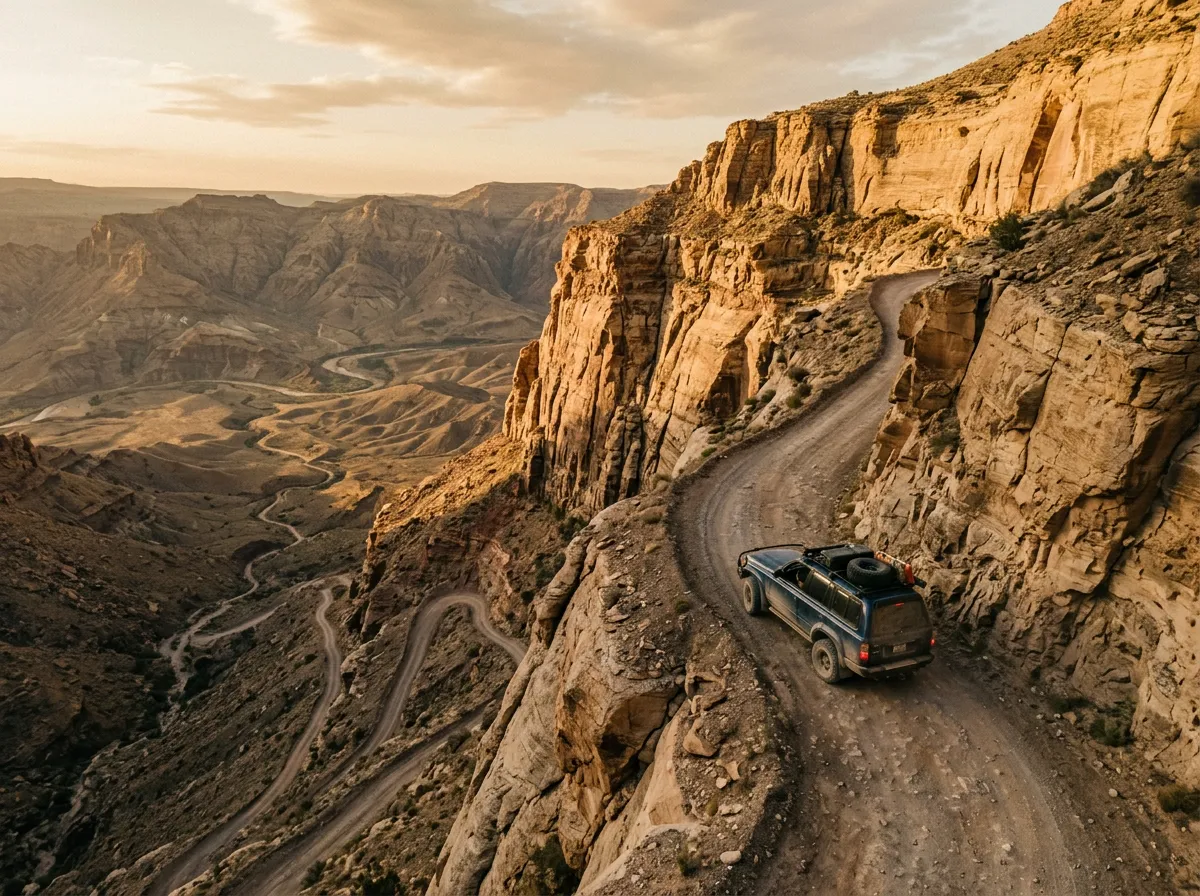
The switchback descent (8 km)
At approximately the 12 km mark, the track turns west and commits to the descent. This is where the drive becomes serious.
The switchbacks drop 900 vertical metres over 8 km. The surface is loose rock and gravel, with embedded boulders in some corners. There are no guardrails — the outer edge of each switchback drops directly into the canyon. The turns are tight enough that a full-sized Land Cruiser needs a three-point turn on some of them. The gradient varies from 10% to approximately 20% in the steepest sections.
Driving technique for the descent:
Engage low-range, first gear. Let the engine braking do the work. Touch the brakes only to control speed on the steepest pitches or to stop completely at tight corners. If you ride the brakes for the full descent, they will fade — we could smell hot brake material from a vehicle that had descended ahead of us, and the rubber stink lingered in the canyon for hours.
Approach each switchback slowly, check the turn radius, and commit. Hesitation on a tight turn with a drop on the outside is worse than a confident, smooth arc. If the turn is too tight for a single manoeuvre, stop, reverse a metre, and complete the turn. There is no shame in a three-point turn on a mountain trail — there is considerable shame in reversing off a cliff.
The entire descent takes 1.5 to 2 hours, depending on how many times you stop. We stopped often — partly for photographs, partly for nerve management, and partly because the canyon geology demanded attention. Each switchback reveals a new layer. The colours shift as you descend: red gives way to yellow, yellow to grey, grey to a dark basaltic black near the canyon floor.
Wadi bed to Feynan (25 km)
At the bottom of the switchbacks, the track enters the Wadi Dana bed. The terrain changes completely — from rocky mountain descent to flat, wide wadi bed with sand and gravel surface. The driving is easier but not effortless: embedded rocks create steps and ledges, and some sections have soft sand that requires momentum.
The wadi is dry for most of the year, but flash flooding is a real risk after rain anywhere in the upstream catchment. The flood evidence is visible in the wadi bed — waterlines on the walls, debris piled against rocks, and the occasional vehicle carcass rusting in the sand, a reminder that people have misjudged this place before. Check the weather forecast before you descend, and do not enter the wadi if rain is predicted anywhere in the Dana watershed.
The final stretch follows the wadi westward, gradually widening as it approaches the Rift Valley floor. The landscape becomes increasingly arid — the Mediterranean vegetation of the highlands gives way to desert scrub, then to almost bare rock and sand. The temperature rises noticeably. By the time you reach Feynan, you are in a different climate zone than where you started.
Feynan (30.6184° N, 35.5123° E)
Feynan is a settlement with a history that reaches back to the Chalcolithic period — copper was mined here 7,000 years ago, and the ancient mine shafts and slag heaps are still visible in the surrounding hills. Today, the primary attraction is the Feynan Ecolodge, a 26-room establishment that operates entirely on solar power and candlelight. It is genuinely off-grid: no generators, no powered lighting after dark, no phone signal. The lodge is popular with hikers doing the Dana to Feynan trail on foot (a 2-day hike that follows a different path from the driving route), and reservations are recommended.
The lodge charges approximately 80-120 JOD per room per night including meals, depending on the season. It is not cheap, but it is the only accommodation between Dana village and the Dead Sea, and the candlelit dinner on the rooftop terrace — looking back up at the canyon you just descended — is a worthwhile conclusion to the drive.
Feynan to the Dead Sea highway (13 km)
From Feynan, a gravel track runs 13 km west to Route 65, the Dead Sea highway. This section is the easiest driving of the entire trail — graded gravel, no steep sections, no technical challenges. It is also where you will find phone signal again, which is useful for confirming your lodge reservation or texting someone to confirm you survived.
From Route 65, you can head north toward the Dead Sea (approximately 80 km to the resort area) or south toward Aqaba (approximately 130 km). Both directions have fuel stations within 20-30 km of the junction.
Geological notes
The canyon walls along the descent display a nearly continuous geological sequence from the Precambrian basement rocks (visible near the Rift Valley floor, approximately 600 million years old) through Cambrian sandstone, Ordovician limestone, and younger sedimentary layers up to the Cretaceous deposits at the canyon rim.
| Layer | Age | Colour | Elevation (approx.) |
|---|---|---|---|
| Cretaceous limestone | ~100 million years | White-grey | 1,200-1,500m |
| Jurassic deposits | ~150 million years | Yellow-brown | 900-1,200m |
| Ordovician limestone | ~450 million years | Grey | 500-900m |
| Cambrian sandstone | ~500 million years | Red-pink | 200-500m |
| Precambrian basement | ~600+ million years | Dark grey-black | Below 200m |
If you have any geological interest at all, this drive is worth it for the canyon walls alone. We have driven through gorges and canyons in Morocco, Oman, and southern Africa, and none of them display the stratigraphic sequence as clearly and continuously as the Dana descent.
Practical logistics
Timing
Start from Dana village no later than 8:00 AM. The descent takes 4-5 hours of driving time, and you want to arrive at Feynan with daylight remaining — driving the wadi bed section in the dark is possible but inadvisable, as the rock steps are hard to see and the flood risk is harder to assess.
Cost breakdown
| Item | Cost |
|---|---|
| Dana Nature Reserve entry | 10 JOD per person |
| Feynan Ecolodge (per room/night) | 80-120 JOD |
| Fuel (Tafila fill-up) | ~25-30 JOD for a full tank |
Combining with other routes
The Dana trail pairs naturally with the King’s Highway detours — Dana village is accessible from the King’s Highway via a short paved road from Tafila. If you are driving south from Amman, do the King’s Highway detours over two days, spend a night in Dana village, and descend to Feynan on day three. From the Dead Sea highway at the bottom, Wadi Rum is approximately 150 km south — doable in a half-day of highway driving.
For similar canyon driving in other countries, the Dades and Todra Gorges in Morocco offer dramatic walls on easier terrain, and the Wadi Bani Khalid to Sur route in Oman provides wadi driving with swimming stops.
What can go wrong
Brake fade. The descent is long and steep. Ride the brakes and they will overheat. Use engine braking in low-range first gear.
Loose surface on switchbacks. Gravel and loose rock can cause wheels to slide on tight corners. Approach slowly, maintain a steady speed through the turn, and do not brake mid-corner.
Flash flooding in the wadi. If rain is forecast, do not enter the wadi section. The floods arrive fast, carry debris, and leave no room for error in the narrow sections.
Overheating on the climb. If you drive this route in the opposite direction (Feynan to Dana — climbing), engine overheating is a risk in summer. The sustained low-speed climb at high load will push coolant temperatures to their limits.
No communication. There is no mobile coverage on the trail. Carry a satellite communicator if you are driving solo, and tell someone your expected arrival time at the other end.
The honest summary
The Dana to Feynan trail is not the longest or the most technically difficult route we have driven. It is, however, the most geologically spectacular. The descent through half a billion years of exposed rock, the shift through four climate zones in three hours, and the arrival at a candlelit ecolodge on the floor of the Rift Valley — these combine into an experience that is difficult to replicate anywhere else we have driven.
It requires a competent vehicle, functional brakes, reasonable nerve on exposed switchbacks, and a weather forecast that does not include the word “rain.” Given those four things, it is one of the best day drives in Jordan.