Wadi Rum Desert Tracks
We got stuck on the second day. Not dramatically — no sand up to the doors, no frantic radio calls — just a gentle, progressive sinking into soft sand in a corridor between two sandstone formations that looked like the set of a science fiction film. The rear wheels found the soft layer first, then the front followed, and within about thirty seconds we had gone from rolling at a steady 25 km/h to sitting motionless with all four tires buried to their rims. The engine was still running. The air conditioning was still on. The only sound outside was wind. This is the standard Wadi Rum experience: long stretches of manageable gravel interrupted by sand traps that are invisible until you are in them, set against scenery so improbable that the actual driving starts to feel like a secondary concern.
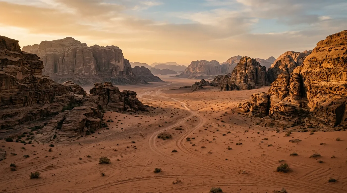
Wadi Rum Protected Area covers approximately 740 square kilometres of desert in southern Jordan, about 60 km east of Aqaba. The landscape is defined by sandstone and granite formations — isolated massifs rising 500 to 700 metres from the desert floor, connected by valleys of sand, gravel, and exposed rock. The tracks that cross this landscape are not roads in any conventional sense. They are routes — worn into the sand by Bedouin trucks, tour vehicles, and the occasional self-driver who has done enough research to attempt it.
We drove 185 km of these tracks over two and a half days in late October, running a loop that covered the major landmarks and several less-visited valleys in the eastern part of the protected area. This guide documents what we found.
Route overview
The tracks we drove form a rough figure-eight centred on the Wadi Rum visitor centre (29.5321° N, 35.4179° E), which is also where you pay the park entry fee (5 JOD per person) and register your vehicle. From here, the main tracks branch south and east into the desert.
| Day | Section | Distance | Terrain | Key stops |
|---|---|---|---|---|
| 1 | Visitor centre to Lawrence’s Spring to Khazali Canyon | ~55 km | Gravel, mixed sand | Lawrence’s Spring, Khazali Canyon inscriptions |
| 2 | Khazali to Burdah Rock Bridge to eastern valleys | ~75 km | Soft sand, rocky wadi, gravel | Burdah Rock Bridge, Um Fruth arch |
| 3 | Eastern loop back to visitor centre | ~55 km | Gravel, intermittent sand | Red sand dunes, Bedouin camp detour |
The tracks are not signed. Navigation is by GPS waypoint, by following existing tire tracks (which can be misleading — not every track leads somewhere useful), and by occasional reference to Bedouin guides who appear from apparently empty desert on motorbikes and offer their services with a confidence that suggests they have seen many visitors looking lost.
Day 1: Visitor centre to Khazali Canyon
The approach and registration
Wadi Rum village sits on the edge of the protected area, about 25 km off the Desert Highway (Highway 15) via a paved road. The village has the last reliable fuel — fill your tank here, completely, even if the gauge reads three-quarters. The petrol station is on the main road through town and is staffed by someone who has clearly seen many overlanders arrive with jerry cans and nervous expressions.
At the visitor centre, you pay the entry fee and register. If you are self-driving (as opposed to hiring a Bedouin guide with vehicle), expect some polite scepticism about your vehicle and your intentions. They will want to know your route and how many days you plan to stay. This is reasonable — the desert is large, the mobile coverage is nonexistent, and people do get stuck.
Lawrence’s Spring (29.5765° N, 35.4193° E)
From the visitor centre, the main track runs south into a broad valley between sandstone cliffs. The surface is packed gravel here — fast, smooth, and misleadingly easy. Lawrence’s Spring is approximately 12 km from the start, marked by a concrete water tank and a few Bedouin shelters. The spring itself is a modest trickle of water emerging from the rock face, notable more for its historical associations (T.E. Lawrence described it in Seven Pillars of Wisdom) than for its visual drama. But the view from the spring — looking south into the desert with the sandstone pillars of Rum catching the morning light — is genuinely worth the stop.
Sand corridors and the first lesson
Between Lawrence’s Spring and Khazali Canyon, the terrain changes. The packed gravel gives way to sand corridors — narrow valleys between rock formations where the wind has deposited fine sand to depths that vary from a few centimetres to a metre or more. This is where most self-drivers have their first encounter with soft sand, and it is where tire pressure becomes the single most important variable.
The physics are straightforward: a deflated tire has a larger contact patch, which distributes the vehicle’s weight over more surface area, which means it sits on top of the sand instead of cutting into it. We run 15 PSI in the soft sections, which is about half of normal road pressure. The difference between 30 PSI and 15 PSI in Wadi Rum sand is the difference between driving and digging.
Tire pressure protocol for Wadi Rum:
| Surface | Recommended PSI | Notes |
|---|---|---|
| Paved road | 32-35 | Normal inflation |
| Packed gravel | 25-28 | Slight deflation for comfort |
| Mixed sand/gravel | 20-22 | Reduces bogging risk |
| Soft sand corridors | 15-18 | Essential for flotation |
| Deep sand recovery | 12-14 | Emergency only, drive slowly |
Carry a tire deflator (the screw-on type that holds a set pressure is worth the 20 USD) and a 12V compressor rated for at least 150 PSI. You will inflate and deflate multiple times per day.
Khazali Canyon (29.5233° N, 35.4017° E)
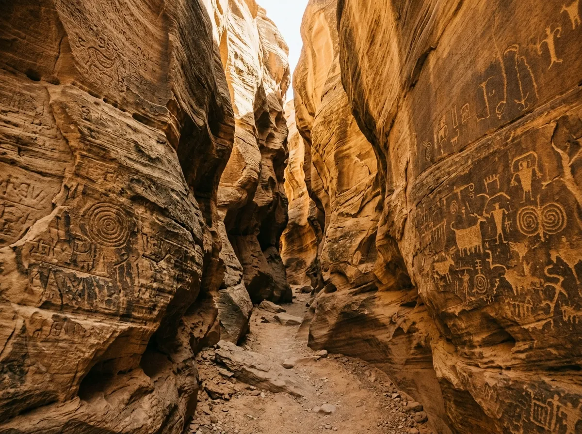
Khazali is a narrow slot canyon cutting into a sandstone formation. You park at the base and walk in — the canyon narrows to about two metres wide and the walls rise 30-40 metres on either side. The rock faces are covered in Nabataean and Thamudic inscriptions: human figures, camels, hunting scenes, symbols that have been there for two thousand years and look as fresh as if they were carved last season. The acoustics inside the canyon are extraordinary — sound bounces between the walls in a way that amplifies whispers and dampens shouts.
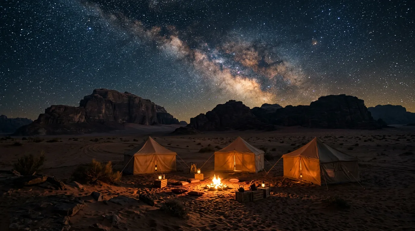
We camped near Khazali on the first night, at a spot where the Bedouin camps cluster on a flat gravel area east of the canyon. The camps range from basic (mattress on the ground, communal dinner, 15 JOD per person) to moderately comfortable (private tent, bedding, hot food, 35-50 JOD per person). Book ahead if you are visiting in October or November — this is peak season and the camps fill up.
Day 2: Khazali to the eastern valleys
The Burdah Rock Bridge approach
The track from Khazali east toward Burdah Rock Bridge is the most technically demanding section of the route. The surface alternates between soft sand, rocky wadi bed, and loose gravel, and the navigation requires attention — there are multiple tracks branching in different directions, most of which lead to dead ends or Bedouin camps rather than to Burdah.
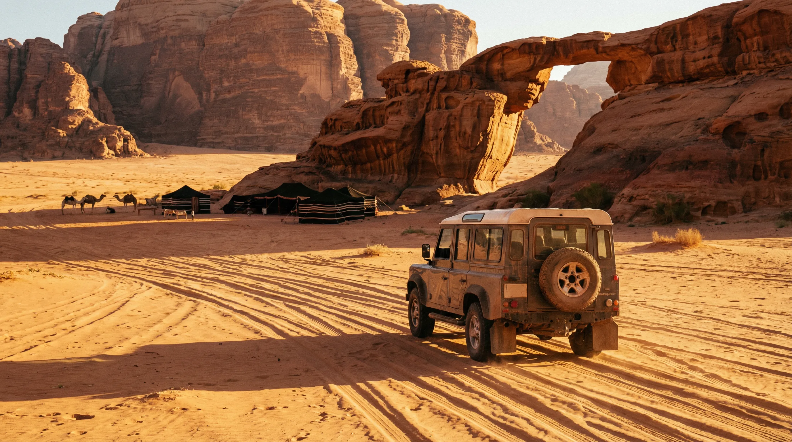
Burdah Rock Bridge (29.5117° N, 35.4300° E) is a natural sandstone arch spanning approximately 35 metres at its highest point. You can see it from the desert floor, which is where most visitors experience it. Climbing to the arch is possible but involves scrambling up loose rock and requires a head for heights. We looked at the approach, assessed our skill level honestly, and decided the view from below was sufficient.
Um Fruth Rock Bridge
Smaller and more accessible than Burdah, Um Fruth (29.5083° N, 35.4350° E) is a rock bridge you can actually climb onto. The scramble takes about twenty minutes and rewards you with a view across the desert floor that puts the scale of Wadi Rum into perspective — formation after formation stretching to the horizon, with the occasional vehicle track scratched into the sand between them like a tentative line on a geological survey map.
Sand driving: what we learned
By the second day, we had developed a working relationship with the sand. The key insights, for what they are worth:
Momentum is everything. In soft sand, the vehicle that keeps moving stays on the surface. The vehicle that hesitates, brakes, or slows down sinks. This sounds obvious until you are approaching a blind corner in a sand corridor and every instinct is telling you to slow down.
Steering inputs should be gentle. Sharp turns in sand dig the front wheels in and stop you dead. Wide, sweeping turns keep the tires rolling over the surface instead of cutting into it.
If you stop, you will probably need to dig. The recovery protocol: place recovery boards in front of the drive wheels, reverse a few centimetres to create a platform, then drive forward over the boards. This works about 80% of the time. The other 20% involves repeating the process with progressively more creative language.
Follow the tire tracks. Existing tracks have compressed the sand slightly, making it firmer. Fresh sand beside the tracks looks the same but behaves differently. We learned this the hard way in a valley east of Burdah.
Eastern valley camp
We spent the second night at a small Bedouin camp in the eastern part of the protected area, about 15 km from the nearest tourist formation. The camp consisted of three goat-hair tents, a fire pit, and a Toyota Hilux that had clearly been in the desert for decades. Dinner was zarb — chicken and vegetables cooked in a pit oven buried in the sand — and it was the best meal of the trip. The camp host, who introduced himself only as Abu Salem, provided route advice for the following day that proved more accurate than our GPS tracks.
Cost: 25 JOD per person including dinner and breakfast. No booking platform — we found the camp by following a track that Abu Salem’s son had mentioned to us at the visitor centre. This is how things work in Wadi Rum.
Day 3: Eastern loop and return
Red sand dunes
The eastern loop passes through an area where the sand shifts from the typical brown-grey to a deep red-orange. The Red Sand Dunes (29.5467° N, 35.4567° E) are a popular tourist stop, and you will likely encounter tour vehicles here even if the rest of your route has been empty. The dunes are photogenic in the morning light but the driving is straightforward — the sand is firmer here than in the corridors further west.
Return to the visitor centre
The final leg runs northwest from the red dunes back to the visitor centre, covering approximately 55 km of mixed terrain. We re-inflated our tires to 25 PSI for the gravel sections and maintained that pressure until we were back on pavement, at which point we stopped and pumped up to full road pressure. Do not drive on tarmac at 15 PSI — it destroys tires and handles dangerously.
Equipment checklist
This is what we carried and what we actually used.
| Item | Required | Notes |
|---|---|---|
| Recovery boards (pair) | Yes | Used three times in two days |
| Tire deflator + 12V compressor | Yes | Used multiple times daily |
| Tow strap (3m, rated 5 tonnes) | Yes | Used once (pulled out by Bedouin truck) |
| Water: 5L per person per day | Yes | Non-negotiable |
| Shovel (folding) | Yes | Used twice for digging out |
| Satellite communicator | Recommended | No mobile coverage in the desert |
| GPS device or offline maps | Yes | Maps.me has reasonable track data |
| Extra fuel (10L jerry can) | Yes | Used about 5L beyond what the tank held |
| First aid kit | Yes | Standard kit, unused |
| Sunscreen, hat, sunglasses | Yes | The obvious but often forgotten items |
Fuel and water logistics
Wadi Rum village is the last fuel. The petrol station closes at sunset in winter — fill up before noon to be safe. Our Toyota Land Cruiser consumed approximately 18L/100km on the desert tracks, which is roughly double its highway consumption. On 185 km of tracks, that meant about 33 litres of fuel. With a 90-litre tank, we had ample reserves, but smaller vehicles with 50-60 litre tanks will need the jerry can.
Water: we carried 30 litres for two people over three days. We used about 25 litres. The Bedouin camps provide water, but you should not rely on this as your primary supply.
Seasonal and weather considerations
The driving season for Wadi Rum is October to March. April is marginal — daytime temperatures start pushing past 35 degrees Celsius. May to September is not recommended: temperatures exceed 45 degrees, and in June through August they regularly reach 48 degrees. At those temperatures, the risk of vehicle overheating, human heat exhaustion, and tire failure all increase sharply.
Winter nights (December to February) drop to near freezing — bring warm layers for camping. Rain is rare but does occur, and a desert rainstorm will turn sand corridors into temporary rivers. Flash flooding is a real risk in the canyon sections.
Wind is the other variable. The shamal wind blows from the northwest and can lift sand to a height that reduces visibility to a few metres. If this happens, stop driving. The sand clears in hours, not days, and driving blind in a desert full of rock formations is an efficient way to damage a vehicle.
Getting there and getting out
From Aqaba: 60 km north on Highway 15, then 25 km east on the signed road to Wadi Rum village. Paved throughout. About 1.5 hours.
From Amman: 320 km south on the Desert Highway (Highway 15). About 4 hours to the Wadi Rum turnoff.
From Petra/Wadi Musa: 110 km south. About 1.5 hours on good highway.
The Wadi Rum area combines well with the Dana to Feynan Canyon Trail — Dana is about 150 km north, accessible in a day. The King’s Highway detours provide good intermediate driving if you are working your way south from Amman. For more desert driving at a larger scale, see our Morocco Sahara piste guide, which covers a 350 km crossing between Merzouga and Zagora.
The honest summary
Wadi Rum is one of the most visually extraordinary places we have driven. It is also one of the most humbling. The sand does not care about your vehicle modifications, your experience level, or your schedule. It will stop you when it wants to, and you will spend time with a shovel and recovery boards that you did not plan for. This is the price of admission, and it is worth paying.
The Bedouin hospitality is genuine, the night sky is the clearest we have seen outside Namibia, and the sandstone formations at sunset will make you forget, briefly, that you have sand in every piece of equipment you own.
Bring water. Bring patience. Deflate your tires.