Wadi Bani Khalid to Sur
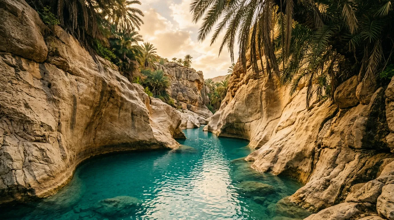
The water was the colour of something from a travel brochure — that saturated turquoise that you assume has been digitally enhanced until you see it with your own eyes and realise that no, some water actually looks like that. It sits in a pool about thirty metres long and ten metres wide, bounded by smooth limestone walls that rise vertically for twenty metres on either side, with a thin fringe of palm trees at the top catching the morning sun. The pool is chest-deep in the centre, clear enough to see the fish (small, silver, numerous) and the pebbled bottom beneath them. The temperature is perfect — not cold enough to shock, not warm enough to feel like a bath. It is the kind of swimming hole that justifies a six-hour flight and a 4x4 rental.
Wadi Bani Khalid is Oman’s most visited wadi, and the reason is the water. Where most Omani wadis are dry for much of the year — stone channels waiting for the next rain — Wadi Bani Khalid flows year-round, fed by springs in the Al Hajar Mountains that maintain a constant output regardless of the season. The result is a chain of permanent pools in a limestone canyon, surrounded by palm groves, accessible by a paved road to the lower pools and a 4x4 track to the upper canyon where the tourists do not go.
The route we drove connects Wadi Bani Khalid to the coastal town of Sur, covering 120 km of wadi, gravel track, and coastal road. It is the most accessible of our Oman routes and the only one where the highlight is a swimming hole rather than a driving challenge. The driving is still good — the upper wadi requires a 4x4 and the gravel tracks between the wadi and the coast are rough enough to be satisfying — but the swimming is what you will remember.
Route overview
| Section | Distance | Terrain | Vehicle needed | Time |
|---|---|---|---|---|
| Ibra to Wadi Bani Khalid lower pools | ~35 km | Paved road, last 5 km narrowing | Any vehicle | 45 min |
| Lower pools to upper wadi | ~8 km | Rocky wadi track, water crossings | 4x4 | 1.5 hours |
| Return to main road | ~8 km | Same track in reverse | 4x4 | 1 hour |
| Wadi Bani Khalid junction to Sur | ~70 km | Paved highway, coastal sections | Any vehicle | 1.5 hours |
Total: approximately 120 km, 5-6 hours including swimming time. The swimming time is the variable — we allocated two hours at the pools and wished for three.
Getting there
Starting point: Ibra
Ibra is a small city approximately 170 km southeast of Muscat, accessible via Highway 23. It has fuel stations (fill up here — the next reliable fuel is Sur, about 100 km away), a hospital, banks, and a Wednesday morning souk that is one of the best in eastern Oman. The souk specialises in textiles, silver jewellery, and Omani handicrafts, and it operates in a traditional covered market that feels authentically local rather than tourist-oriented.
From Ibra, Route 33 runs east toward the Al Hajar foothills. After about 25 km, a signed turnoff leads north to Wadi Bani Khalid. The approach road is paved and in good condition.
The approach to Wadi Bani Khalid
The paved road from the highway to the wadi parking area is about 10 km long. It follows the wadi downstream, passing through a palmerie (date palm oasis) that narrows as the canyon walls converge. The road is two lanes wide and manageable in any vehicle. There is a small parking area at the end of the paved road, where a parking fee of 0.5 OMR is collected by an attendant.
From the parking area, a concrete path leads about 400 metres to the first (lower) pool. This is where most visitors go, and where the tour buses disgorge their passengers by mid-morning.
The lower pools
The lower pools of Wadi Bani Khalid are genuinely beautiful. The main pool is a natural swimming hole bounded by limestone walls, fed by a small waterfall from the pool above. The water is turquoise, clear, and permanently flowing — the spring output is estimated at 15-20 litres per second, which keeps the pools fresh and the temperature constant at about 25 degrees Celsius year-round.
Facilities at the lower pools include a small cafe (coffee, cold drinks, basic food), changing rooms, and toilets. The cafe prices are reasonable by Omani tourism standards — a coffee is about 0.5 OMR, a cold water 0.3 OMR.
Timing advice: Arrive before 9:00 AM. The tour buses from Muscat and Ras al Hadd typically arrive between 10:00 and 11:00 AM, and the pools go from serene to crowded within about thirty minutes. Early morning also provides the best light — the sun illuminates the canyon walls from the east, creating the contrast between lit stone and turquoise water that makes the wadi so photogenic.
On Fridays (the Omani weekend), local families visit in large numbers. The atmosphere is lively and friendly, but if you prefer solitude, come on a weekday.
Swimming notes
The lower pool is chest-deep in the centre and shallow at the edges. The current is gentle but present — you can float without effort. The fish are harmless. The rocks at the pool edges are smooth but slippery — enter and exit carefully.
A second pool sits above the first, accessible via a short scramble up the rocks on the left side. This pool is smaller, less visited, and surrounded by narrower canyon walls that create a more intimate atmosphere. A third pool above that is reachable but requires some scrambling ability.
The upper wadi: where the tourists stop
Above the third pool, the maintained path ends and the wadi becomes a driving route. This is where the experience shifts from tourist attraction to off-road adventure.
The track
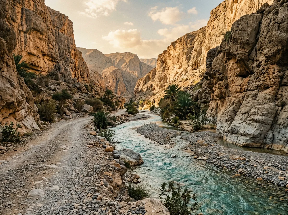
A 4x4 track follows the wadi upstream from a vehicle access point about 500 metres north of the parking area (not from the walking path to the pools — return to the parking area and take the track that branches north). The track runs along the wadi bed and the gravel banks beside it, crossing the water multiple times.
Water crossings: The crossings are shallow — shin to knee-deep in the dry season (October to April), deeper after rain. The bed is rocky and uneven, with embedded boulders that require ground clearance of at least 200mm. A high-clearance 2WD can handle the first 3-4 km of the upper wadi in dry conditions; beyond that, the crossings deepen, the boulders get larger, and 4x4 is necessary.
Track condition: Rocky wadi gravel, embedded boulders, sand patches. The main challenge is the water crossings and the rock steps between them. Speed limit: walking pace. Any faster and you risk damaging the underside of the vehicle on hidden rocks below the water surface.
The caves (approximately 5 km upstream)
About 5 km up the upper wadi, the canyon narrows and the track passes a series of caves in the limestone walls. These are dissolution caves — formed by water dissolving the limestone over millennia — and some of them are large enough to drive into (though we do not recommend it, as the ceilings are unpredictable). The caves have natural light wells where the roof has partially collapsed, creating shafts of sunlight that illuminate the cave floor in dramatic columns.
The caves are not marked or developed. There are no paths, no signs, and no other visitors when we were there. This is the upper wadi’s reward for the driving effort — a completely different experience from the touristy lower pools, just 5 km upstream.
Beyond the caves
The track continues upstream for another 3-4 km beyond the caves before deteriorating to a boulder field that would require a motorcycle or exceptional determination to navigate. We turned back at the caves, which is the natural endpoint for a vehicle.
The return drive downstream is slightly easier — you know where the deep spots and big rocks are — and takes about an hour.
Wadi Bani Khalid to Sur (70 km)
The coastal transition
From the Wadi Bani Khalid junction, return to Route 33 and continue east. The road crosses the eastern foothills of the Al Hajar range through a landscape of gravel plains and low, rocky hills — dry, brown, and sparse. The terrain is unremarkable but the driving is easy, and after the concentration of the wadi track, easy driving is welcome.
At approximately the 40 km mark, the road crests a low ridge and the Indian Ocean appears — a blue line on the horizon that grows as you descend to the coastal plain. The landscape shifts from interior desert to coastal scrubland, with fishing villages appearing along the shore.
The coastal road
The final 30 km into Sur follows the coastline, passing through small fishing settlements and past sandy beaches that are mostly empty. The road is paved and fast (speed camera at the village boundaries — 80 km/h limit). This section is a palate cleanser between the wadi’s canyon intimacy and Sur’s port-town bustle.
Sur (22.5667° N, 59.5283° E)
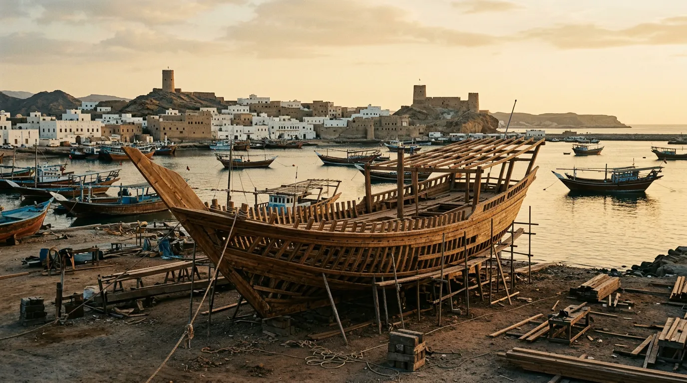
Sur is a port town at the eastern tip of Oman, with a history that stretches back to the maritime trade routes connecting the Arabian Peninsula to East Africa, India, and beyond. The town’s primary attraction for most visitors is the dhow shipyard, where traditional wooden sailing vessels are still built by hand using methods that have not changed meaningfully in centuries.
The dhow shipyard
The shipyard (Al-Ghanjah yard) sits on the waterfront on the eastern side of town. It is open to visitors without charge (though donations are appreciated). The dhows under construction are large — 15-20 metres in length — and the construction is done entirely by hand, with adze, saw, and hammer. The wood is teak, imported from India. The hull planking is fastened with nails and caulked with fish oil and cotton.
The workers are generally happy to explain the process to visitors who show genuine interest. We spent about an hour watching a hull being planked and learned more about wooden boat construction than we expected, including the fact that modern dhows still use many of the same techniques described by Ibn Battuta in the 14th century.
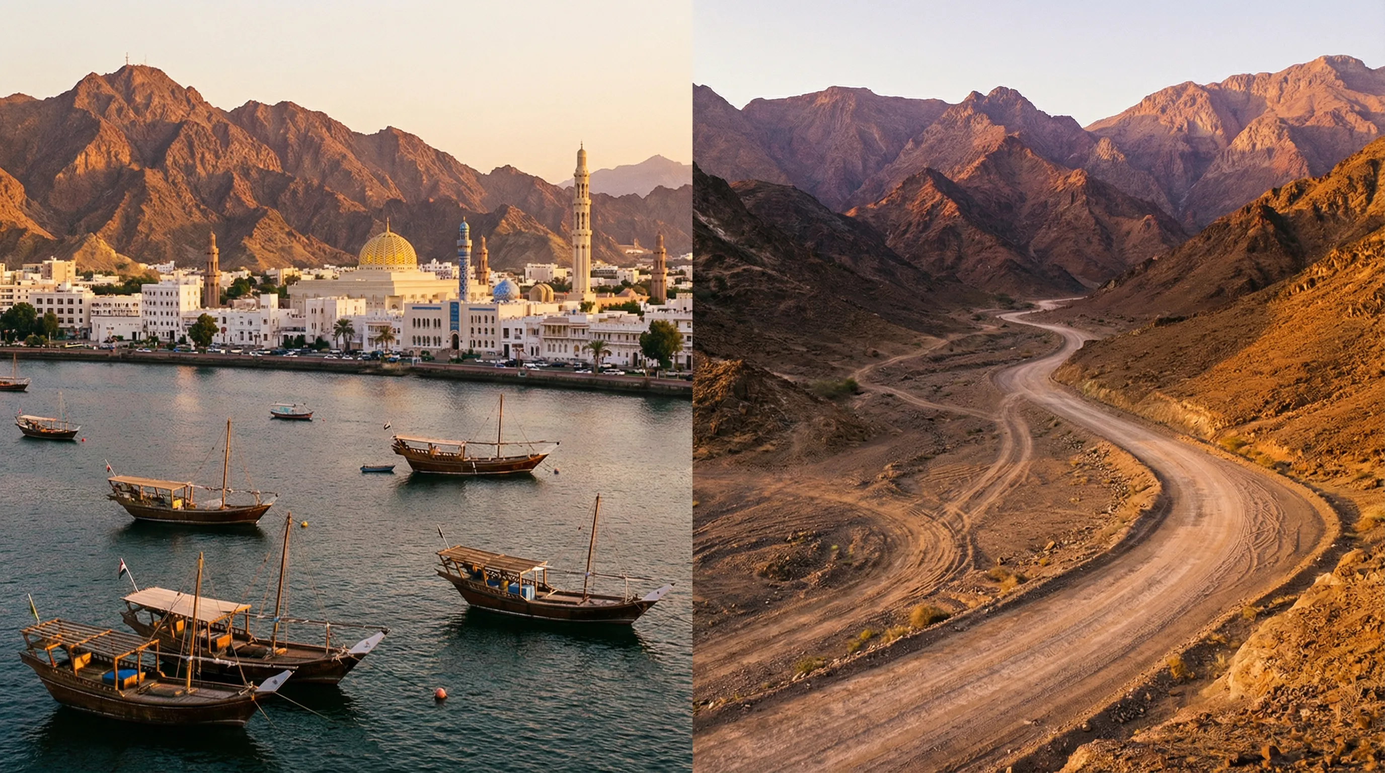
Sur lighthouse and lagoon
The Ayjah watchtowers and lighthouse overlook the lagoon on the east side of Sur. The lagoon is a natural harbour, now filled with fishing boats and the occasional dhow. The watchtowers (three of them, restored) date from the town’s defensive period and provide good viewpoints over the town, lagoon, and coast. Access is free.
Ras al Jinz turtle reserve
About 45 km southeast of Sur (a worthwhile side trip if your timing allows), the Ras al Jinz turtle reserve is one of the most important green turtle nesting sites in the Indian Ocean. During nesting season (June to November), guided night visits allow you to watch the turtles come ashore, dig nests, and lay eggs. This requires advance booking through the reserve’s visitor centre (3 OMR per person for the night visit).
Practical information
Fuel
| Location | Notes |
|---|---|
| Ibra | Multiple stations, fill up here |
| Wadi Bani Khalid area | No fuel |
| Sur | Multiple stations |
The fuel gap between Ibra and Sur is about 100 km via Route 33. With the wadi detour added (about 20 km round trip to the lower pools, 16 km round trip for the upper wadi), the total distance is about 135 km. This is within range of any vehicle on a full tank, but fuel up in Ibra to be comfortable.
Costs
| Item | Cost |
|---|---|
| Wadi Bani Khalid parking | 0.5 OMR |
| Cafe at lower pools (coffee + snack) | 1-2 OMR |
| Fuel (Ibra to Sur) | ~5 OMR |
| Sur accommodation (mid-range) | 15-30 OMR per night |
| Ras al Jinz turtle visit | 3 OMR per person |
What to bring
| Item | Notes |
|---|---|
| Swimwear and towel | The pools are the main attraction |
| Water shoes or sandals with grip | The wadi rocks are slippery |
| Waterproof bag for electronics | For the swimming stops and water crossings |
| Water (3L per person) | Hot drive between wadi and coast |
| Sunscreen | The canyon provides shade but the drive to Sur does not |
Flash flood awareness
Wadi Bani Khalid flows year-round, but after rain in the Al Hajar Mountains, the flow can increase dramatically. The upper wadi is particularly susceptible — the narrow canyon concentrates water and debris, and water levels can rise by a metre or more within minutes of a storm upstream. The evidence is visible in the wadi: waterlines on the walls 3-4 metres above the normal pool level, debris wedged between boulders, and the occasional uprooted palm tree deposited in improbable locations.
Rules for wadi driving:
- Check the weather forecast for the entire Al Hajar range, not just the wadi area. Rain 50 km upstream affects the wadi.
- If the water is brown or muddy (normally it is turquoise-clear), do not enter the wadi — this indicates upstream rain and rising water.
- Do not park in the wadi bed. Park on high ground above the waterline.
- If you hear a roaring sound upstream, move to high ground immediately. Do not try to drive out — water moves faster than a vehicle on a wadi track.
Seasonal notes
The wadi is swimmable year-round, but the water temperature varies — about 25 degrees in summer (October), dropping to about 20 degrees in winter (January). The lower pools are always accessible. The upper wadi track may be impassable for a few days after heavy rain, when the water level rises above the crossing depth.
The turtle season at Ras al Jinz (June to November) makes a summer visit worthwhile despite the heat, if you combine the wadi swim with a turtle night visit. Be aware that summer temperatures on the coastal road reach 40+ degrees.
Combining with other routes
This route connects naturally with the other Oman routes:
From Wahiba Sands: Exit the sands on the eastern side and drive to Wadi Bani Khalid (approximately 50 km from the eastern sand edge to the wadi). The wadi swim is an excellent counterpoint to the previous day’s sand driving.
To Jebel Akhdar: From Ibra, drive northwest to Nizwa (approximately 130 km, paved), which is the base for the mountain road.
From Sur back to Muscat: The coastal road (Route 17) runs 350 km along the Sharqiya coast. It is a long day’s drive but scenic, passing through fishing villages, coastal cliffs, and the occasional turtle beach.
For comparable wadi driving in other countries, the Dana to Feynan canyon trail in Jordan offers more demanding wadi-bed driving with similar geological beauty, and the King’s Highway detours include wadi sections with hot springs.
What makes this route worth it
This is not our most demanding route, our most remote route, or our most technically challenging route. It is, however, the route that most consistently makes people smile. The wadi pools are that good. The upper canyon is that empty. The dhow shipyard in Sur is that interesting. And the drive between them, across the gravel foothills and down to the Indian Ocean coast, provides the kind of landscape transition — from mountain water to desert rock to tropical sea — that reminds you why driving is a better way to see a country than flying over it.
Bring swimwear. Bring a towel. Arrive before the tour buses.